Freising Waterscapes Team 6 2022: Difference between revisions
| Line 46: | Line 46: | ||
''Flood risk is a rising threat in the waterscape of Freising. It is clearly visible the projections for a 100-year flood would risk a large part of build upon area. This needs to be considered for the rest of the project.'' | ''Flood risk is a rising threat in the waterscape of Freising. It is clearly visible the projections for a 100-year flood would risk a large part of build upon area. This needs to be considered for the rest of the project.'' | ||
''The geomorphological story of the area is largely defined by the alps to the south and upstream to the Isar and Moosach. The alps create sediments in the area of gravel and larger rocks. The direct influence of the Alps cannot be underestimated.''<gallery | ''The geomorphological story of the area is largely defined by the alps to the south and upstream to the Isar and Moosach. The alps create sediments in the area of gravel and larger rocks. The direct influence of the Alps cannot be underestimated.''<gallery widths="200" heights="150" perrow="5"> | ||
File: | File:Geomorphology.png|Geomorphology | ||
File: | File:Contours and Hillshade.png|Contours and Hillshade | ||
File: | File:Floodrisk 100 years .png|Floodrisk 100 years | ||
File:Hochwasser 100 year in hillshade.png|Hochwasser 100 year in hillshade | |||
</gallery> | </gallery> | ||
Revision as of 14:09, 29 April 2022
>>>back to working groups overview
| Area | Freising | |
| Place | Upper Bavaria | |
| Country | Germany | |
| Topics | water areas, landscape, society, public | |
| Author(s) | Anastasiia Puzeikina, Farhin Esmaeilian,
Jaromir Janszen, Pasu Vascharaprakarn, Louisa Schleicher | |

| ||
Rationale
Moosach, a 38 Kilometers long river, is a tributary of the Isar river near Munich, Bavaria, Germany. Moosach, as a main water area of Freising, has played a significant role in characterizing Freising’s landscape for centuries. Recently, urbanization, climate change, population growth, and construction have negatively affected water systems. As a result, study and analysis of the Moosach waterscape would be vital for the river and its influenced area such as environment, nature, society, economy, land use, and settlement.
Location and scope
You can edit this map with the map editor
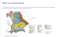
Water as a natural system
Geomorphology, typologies and dynamics of water areas
The landscape of the Freising waterscape is defined by the hillside on the northern part of the area. The southern part of the area is a valley. This in large part determines the way of waterflow in the area. The Moosach is a part of the larger Danube watershed.
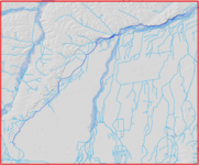
Flood risk is a rising threat in the waterscape of Freising. It is clearly visible the projections for a 100-year flood would risk a large part of build upon area. This needs to be considered for the rest of the project.
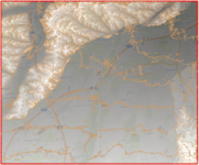
The geomorphological story of the area is largely defined by the alps to the south and upstream to the Isar and Moosach. The alps create sediments in the area of gravel and larger rocks. The direct influence of the Alps cannot be underestimated.
Geomorphology
Contours and Hillshade

Floodrisk 100 years
Hochwasser 100 year in hillshade


Water as a living space
- Which habitats can be found in and along the water areas of your area?
- How is the water quality in your water areas?
- Which areas are still natural, which are urbanized/artificial?
- Your case green blue infrastructure1.jpg
add a caption
- Your case green blue infrastructure2.jpg
add a caption
Blue and Green Infrastructure
- What are the major potential elements of a green/blue infrastructure network? Are these likely to change/disappear? Why is that?
- You find my background material on green infrastructure in our reading list
- add 1-2 graphical representations to the image gallery, you can add more if you like
- Your case green blue infrastructure1.jpg
add a caption
- Your case green blue infrastructure2.jpg
add a caption
Water as a cultural space
Land use and water
- map the land uses along your water areas: settlements, infrastructure, agriculture, resource extraction, natural areas, energy production...
- describe in particular the historical evolution of land use pattern, please make use of historical maps
- description evolution, status quo and driving forces, is the land use likely to change? Why is that? (approx 200 signs)
- add 1-2 graphical representations to the image gallery, you can add more if you like
- Yourcase landuse1.jpg
add a caption
- Yourcase landuse2.jpg
add a caption
- Yourcase landuse3.jpg
add a caption
Cultural and spatial typologies of water areas
- Which spatial patterns have evolved in relation to your water areas?
- What is the role of water areas within the overall urban morphology? (approx 200 signs)
- add 1-2 graphical representations to the image gallery, you can add more if you like
- Yourcase water space1.jpg
add a caption
- Yourcase water space2.jpg
add a caption
- Yourcase water space3.jpg
add a caption
Sacred spaces and heritage
- Which places/elements hold cultural value and to whom?
- You may add a map and some images, please also explain in your caption why these elements are valuable
- Your case sacredspace1.jpg
add a caption
- Your case sacredspace2.jpg
add a caption
- Your case sacredspace3.jpg
add a caption
Visual appearance and landscape narrative
- Which elements are essential for the landscape character?
- Has the landscape been painted or otherwise depicted, when and whom? Which elements are essential?
- Which narratives exist? Who has written about this landscape or depicted it in some way?
- You can add text and images
- Your case character1.jpg
add a caption
- Your case character2.jpg
add a caption
- Your case character3.jpg
add a caption
Water and People
Accessibility and usability
- Where are your water areas accessible, and where not? How strong are spatial obstacles preventing access?
- Who is using the spaces and how?
- Yourcase youraccessbilitymap.jpg
add a caption
- Yourcase usepatterns.jpg
add a caption
Community Mapping
What is to be mapped here?
- Social groups from within the community, for example the youth, kids, students, parents, the retired etc. Typically, these groups have specific needs, which you can also make explicit on the map. These people might not be organized in any way, but they are usually present in the context you are observing
- Local stakeholder groups: these groups are organized in one or the other way. They only exist within the community context you are observing. For example: the local community center, local churches, local interest groups, the landowners, small businesses and retailers
- External stakeholder groups are not necessarily present in the environment you are observing, but they may have strong stakes and interests. These can be local authorities, politicians, associations, care services etc.
- For each group, you may identify their needs, objectives, power and capacities
- You may also identify gaps and power conflicts
- Please try to redepict these elements in an integrated way and in relation to your water landscape. What is the relationship between these groups? Are they close or distanced from each other? Who is more powerful? Which voices are hardly heard? Do they have any shared concerns?
- Your case your community map1.jpg
add a caption
- Your case your community map2.jpg
add a caption
- Your case your community map3.jpg
add a caption
Possible Futures
- You can summarize your findings with a SWOT diagram and a DPSI(R) Model
- Link back to the Sustainable Development Goals: Which goals are at risk?
- What is your worst case scenario for this landscape?
- What is your best case scenario for this landscape?
- Present your scenarios in the form of a collage or sketch
- Add text and visuals
- Your case your spider diagram or dpsir model.jpg
explain your analysis briefly in the caption
- Your case yourworstcase visual.jpg
explain your worst case scenario briefly in the caption
- Your case yourbestcase visual.jpg
explain your best case scenario briefly in the caption
Collaborative Goal Setting
- Define strategic planning objectives based on the evaluation findings from your analysis
- Ideally, involve the community of your living labs into this process
- Link back to your original targets from section one and the Development Goals
- 150 words text contribution
Spatial Strategy and Transect
- translate your strategic goals into a vision
- develop a spatial translation of your vision
- exemplify your vision in the form of a transect with concrete interventions
- add map(s) and visualizations
- Your case spatial translaton vision.jpg
add caption here
- Your case transect.jpg
add caption here
- Your case transect detail1.jpg
add caption here
- Your case transect detail2.jpg
add caption here
From Theory of Change to Implementation
- For implementing your vision: Which partnerships are needed? Which governance model is required?
- Who needs to act and how? Draw and explain a change/process model/timeline
- Which resources are needed? On which assets can you build?
- add 150 words text and visuals

add caption here

add caption here


References
- give a full list of the references you have used for your case
Process Reflection
- Reflect in your intercultural and interdisciplinary team on the outcomes of your study
- Which limitations were you facing?
- What have you learnt from each other?
- What did you learn in the Living Labs?
- What would you do differently next time?
- You can also use diagrams/visuals
- 250 words text