East Freising Master Climate Change 2022: Difference between revisions
Rok.brisnik (talk | contribs) |
Juan.ovalle (talk | contribs) (Main topics of the tempalte) |
||
| Line 11: | Line 11: | ||
{| align="right" width="400pt" style="background:Gainsboro; color:black" | {| align="right" width="400pt" style="background:Gainsboro; color:black" | ||
|- | |- | ||
| '''Area''' ||style="background:Lavender"| | | '''Area''' ||style="background:Lavender"| The Freisinger Moos | ||
|- | |- | ||
| '''Place''' || style="background:Lavender"| | | '''Place''' || style="background:Lavender"|Freising | ||
|- | |- | ||
| '''Country''' || style="background:Lavender"| | | '''Country''' || style="background:Lavender"|Germany | ||
|- | |- | ||
| '''Topics''' || style="background:Lavender"| | | '''Topics''' || style="background:Lavender"|WAVE Project | ||
|- | |- | ||
| '''Author(s)''' || style="background:Lavender"| | | '''Author(s)''' || style="background:Lavender"|Pia Röder, Cecilé Augustoni, Rok Brišnik, David Abigaba, Juan Miguel Ovalle, Sophia Kremser | ||
|- | |- | ||
| colspan="3" align="center" style="background:silver"| [[File:Dummy image case study template.jpg|400px]] | | colspan="3" align="center" style="background:silver"| [[File:Dummy image case study template.jpg|400px]] | ||
| Line 30: | Line 30: | ||
= Rationale = | = Rationale = | ||
*''Why do you think this case is relevant? What is your hypothesis considering the landscape challenges?'' | *''Why do you think this case is relevant? What is your hypothesis considering the landscape challenges?'' | ||
* | *Climate change is here. What does this mean for our area? Is our area the source or sink? How can we improve the area by using adaptation and mitigation processes in the hydrographic field? | ||
= Location and scope = | = Location and scope = | ||
| Line 40: | Line 40: | ||
= Water as a natural system = | = Water as a natural system = | ||
== Geomorphology, typologies and dynamics of water areas == | == Geomorphology, typologies and dynamics of water areas == | ||
*''Describe the water areas of your area in the contxt of the wider water system'' | *'''''Describe the water areas of your area in the contxt of the wider water system''''' | ||
*''How does water appear in the landscape of your living lab? What types of water areas are common? | The most significant water feature in the project area is River Moosach, with numerous small sub-tributaries cutting across majorly in the southwestern part. River Moosach is a left tributary of Isar and Amper rivers. Most water features are located in the peatland area, where the water table is higher and the forested areas are in the project area's northern part. | ||
*''Please identify the water bodies' catchment areas, tributaries and floodplains | *'''''How does water appear in the landscape of your living lab? What types of water areas are common?''' '' | ||
*''Which dynamics do these water areas have?'' | Water within the catchment area flows in small river streams. The river banks have signs of continuous erosion, with soils falling into the main river streams and forming uneven excavations along the river banks. Water appears on top within the peatland area since the water table has risen following peatland restoration measures. However, parts of the peatland where no restoration has been done continue to be wet but with no visible surface water. In some fields, water has been drained to allow farmers grow pasture for livestock. This has created conflicts between the peatland restoration community and the farmers. Whereas farmers are more concerned about viable land for pasture production, draining the peatland and reducing the water table emits more carbon centrally to the objective of the peatland restoration team. | ||
*''Have there been any flood events in the past?'' | *'''''Please identify the water bodies' catchment areas, tributaries and floodplains''''' | ||
*'''''Which dynamics do these water areas have?''''' | |||
*'''''Have there been any flood events in the past?''''' | |||
The watershed is not prone to floods. However, On the night of June 3, 2013 River Moosach broke its banks following a heavy downpour. This led to flooding of the surrounding areas though mostly agricultural fields in the project area were mostly affected since the settlements are a bit far from the river. | |||
*''add 2-3 graphical representations to the image gallery, you can add more if you like'' | *''add 2-3 graphical representations to the image gallery, you can add more if you like'' | ||
*''try to use drawings that express the '''system dynamics''''' | *''try to use drawings that express the '''system dynamics''''' | ||
| Line 80: | Line 83: | ||
== Blue and Green Infrastructure == | == Blue and Green Infrastructure == | ||
*''What are the major potential elements of a green/blue infrastructure network? Are these likely to change/disappear? Why is that?'' | *'''''What are the major potential elements of a green/blue infrastructure network? Are these likely to change/disappear? Why is that?''''' | ||
Green infrastructure is a water management approach that recovers, protects and mimics the natural water cycle. This goal can be achieved through natural environment and engineered systems. 18.52% (1447 ha) of our area is forested. Only 26ha is in peatland. In the north we have a larger area of Freisinger Forst. This is a mixed stand of oak and beech (70% beech, 30% oak). Age of the forest is above 170 years for oak and above 150 years for beech. Forest was planted on former farmland, therefore this is human made forest, not natural. Beside this comprehensive forest area, we also count forest borders, smaller forest islands and hetches (69 ha). A large part of the area is covered by peatland. In its natural state, the moorland has a positive impact on the water cycle, as it retains flood waters and filters water. Unfortunately, the Freisinger Moos has been largely exploited in the past for peat harvesting, which has greatly altered the moor. The agricultural activity that still takes place on the moor today has lowered the water level, which is again not good from the point of view of the natural water cycle. Nevertheless, the situation in the marsh is improving and restoration is ongoing. The part of the area dedicated to nature protection is increasing, as various stakeholders are buying land for the compensation points system. The nature conservation areas improve the habitat possibilities of flora and fauna, which also have an impact on the natural water cycle through their activities (e.g. paludiculture). | |||
Our area therefore has a number of potentials. The widespread road infrastructure (farm tracks, forest tracks, etc.) offers good opportunities for recreation. To make even better use of it, we should install some more benches, signposts, etc. Recreation areas could find place in already existing forest and field roads. The traffic load of these roads is small, so it is suitable for pedestrians and cyclists. These roads are not paved, so they are not suitable for some forms of recreation. However, care must be taken here not to overburden recreation in the forest and swamp area, as these areas are important for biodiversity. Biodiversity is very diverse, so it is important to preserve it and encourage its development and multiplication. This can be done by maintaining habitat conditions in their natural state and with revitalization of destroyed habitats back to their natural status. The area has many small streams and rivers. It is necessary to ensure that these remain in their natural course or that rivers that have already been artificially dammed are restored to their original state. This moderates the flow velocity, as the water does not flow forward as quickly as through canals, but is retained in the area. | |||
On the other side, we have a lot of artificial pressure on the area. There are few big roads, which connect smaller settlements to each other. There are much smaller roads (forest and field roads), which are used for the purpose of maintenance of foresta and agricultural land. In the area there are few small villages. We need to ensure that settlements will not spread onto agricultural and natural land – preventing land use change. The proximity to the airport, settlements, road infrastructure (minor link roads, motorway) makes the area prone to noise and light pollution. Besides infrastructure there is one another important factor of impact in our area – agriculture. Due to the good soils, the northern part of the area is heavily used for agriculture, with very little uncultivated land. Agriculture uses fertilizers, which pollute the water. Since this is a hilly area soil erosion occurs. Soil is transported to the rivers nearby, which means water gets saturated with silt. One of the main rivers of soil transport in our area is Moosach. Beside this Moosach was already polluted by malachites (disinfectants) from fish farms nearby. Therefore water quality needs to be protected. | |||
* ''You find my background material on green infrastructure in our [[WAVE_Seminar_Reading_List|reading list]]'' | * ''You find my background material on green infrastructure in our [[WAVE_Seminar_Reading_List|reading list]]'' | ||
*''add 1-2 graphical representations to the image gallery, you can add more if you like'' | *''add 1-2 graphical representations to the image gallery, you can add more if you like'' | ||
<gallery | <gallery widths="200" heights="150" perrow="5"> | ||
File: | File:Blue and Green Infrastructure.jpg|Natural and Artificial river structures | ||
File: | File:Index.php?title=File:Your case green blue infrastructure2.jpg|''add a caption'' | ||
</gallery> | </gallery> | ||
= Water as a cultural space = | = Water as a cultural space = | ||
== Land use and water== | == Land use and water== | ||
*''map the land uses along your water areas: settlements, infrastructure, agriculture, resource extraction, natural areas, energy production...'' | *'''''map the land uses along your water areas: settlements, infrastructure, agriculture, resource extraction, natural areas, energy production...''''' | ||
The hilly area consists of two watersheds. The Kleinbacherner ditch and the Sünzhausener ditch.The third part of our project area is the Freisinger Moos a fen. The catchment area of both watersheds is the Freisinger Moos. Settlements are spread over the hilly areas, whereby the two name-given settlements, Kleinbachern and Sünzhausen lying along the watershed's water axis. A few smaller villages are spread like Haxhausen and Pellhausen. Furthermore, there are individual hamlets, secluded farms and small residential areas. The infrastructure, especially the roads following along the water axis in order to connect the villages with the main road, whereby this main road separates the hilly area from the peatland. As can be seen on the historical maps, the street as a separation between the hills and the plain is old and exists at least since 1857. The location of the road is caused by the difficult soil conditions in the wet areas. Parallel to this road a high voltage transmission line crosses the whole area, to ensure the energy supply of the city of Freising. As well an additional line crosses the peatland. | |||
* agriculture | |||
* | The agricultural land use depends primarily on the soil and wetness conditions. In the hilly area the places with the best soil and steepness conditions are used more intensively for arable land use, whereby in the steep slopes the grassland usage is more common. A part of the hilly area is also covered by forests and small woody features such as hedges, bushes and scrubs. Natural areas are in general not given. Some parts of the forests and the peatland could still be considered as low managed. There is still more or less natural characteristic vegetation present. The Freisinger Moos is a landscape protection area and includes designated bird protection areas and flora-fauna habitat areas. | ||
* | |||
* | Forests provide additional services in the landscape. Besides recreational services, forests reduce emission and noise pollution, protect habitats and landscapes and general resources. Especially the peatland forests containing a historically valuable forest stock. Additional, forests play an important role for soil conservation and climate conservation. | ||
The peatland is predominantly used as grassland with partial extensive pasture use. Despite the humid conditions in this area, drainage allows arable land use partly also intensive. The main area is used for hunting. Groundwater protection playes also an important role in the peatland. For that reason flowering areas are created that provides besides water protection based on the reduction of agricultural use also nature and habitat protection. Partly the peatland is used as compensation area for residential land, commercial areas and roads. | |||
In the peatland area is also a peatland research station located. It is a test facility in the research project 'MOORuse' for the measurement of the CO2 outgassing of the rewetted fen soil with four planting variants in the Freising moss. This is fundamental research for an alternative wetland land use system like paludiculture. Also its contribution to climate mitigation, its environmental effects and profitability is investigated. | |||
The peatland is also an important recreation area for the Freisinger inhabitants. The flat area invites you to walk and cycle. Horse riding trips are also made there. | |||
*'''On the hills:''' The Hills were used mostly for agriculture on the sides and Woodlands on top. Woodlands were mostly coniferous (which year is that map?) - used for timber production. | |||
*'''In the peatland:''' Freisinger Moos is a fen area, crossed by the river Moosach as the largest flowing waters. Coming from the Freising moss, the Moosach divides into several arms in the city area, some of which humans have artificially created for mills. This huge lowland moor complex was shaped for decades by the use of mowing pasture and peat pits. | |||
* '''''describe in particular the historical evolution of land use pattern, please make use of historical maps''''' | |||
In the first half of the 20th century there were massive interventions in the water balance. But as it was traditionally used extensively until the 1960s, the character of the Freisinger Moos was largely preserved. The landscape is characterized by small-scale peat cutting, litter meadows and a close juxtaposition of various wetland and wet meadows. | |||
The Moosach river at first free is later in a canal. On the map from 1940 it is completely canalized but the process started long before. | |||
The structural change in agriculture, especially since the 60th, has had drastic consequences for the Freisinger Moos. There was a large-scale intensification of land use and the forms of use that had become unprofitable, such as small-scale peat cutting, were abandoned. Willows and bushes started colonizing the no longer mown meadows and peat bogs. | |||
For the last 20 years, the district of Freising and the municipality of Neufahrn bought up fallow sites and renaturalized them | |||
*'''''description evolution, status quo and driving forces, is the land use likely to change? Why is that? (approx 200 signs)''''' | |||
Despite massive interventions in the water balance, which occurred mainly in the first half of the 20th century, the character of the Freisinger Moos remained largely intact, as it was traditionally used extensively until the 1960s.However, the structural change in agriculture also had drastic consequences for the Freising moss. The large-scale intensification of land use, combined with the abandonment of unprofitable forms of use, such as the use of litter meadows to obtain litter, began to change the landscape and its habitats | |||
In order to mitigate the climate change the role of peatland as carbon storage is increasing. That fact leads to the assumption that extension of nature reserve areas, extensive land use or alternative peatland use system like paludiculture might be implemented in the future. These benefit of carbon storage through the peat build up, based on rewetting actions of the drainaged peat areas. As side-effect natural peatland plant vegetation is artificially settled or spreads naturally again. | |||
The main drivers of agricultural land use are the social acceptance, political framework and the change in agricultural subsidies. | |||
* Conflit stronger - Population increase (so more food and space needed)? but not in moor -> more awareness | |||
* Water and climate change - pronostic = less water => dangerous for the water balance - (hot summer dangerous for moor?) | |||
* | |||
*''add 1-2 graphical representations to the image gallery, you can add more if you like'' | *''add 1-2 graphical representations to the image gallery, you can add more if you like'' | ||
<gallery caption=" " widths="200px" heights="150px" perrow="5"> | <gallery caption="" widths="200px" heights="150px" perrow="5"> | ||
File:yourcase_landuse1.jpg|''add a caption'' | File:yourcase_landuse1.jpg|''add a caption'' | ||
File:yourcase_landuse2.jpg|''add a caption'' | File:yourcase_landuse2.jpg|''add a caption'' | ||
| Line 117: | Line 143: | ||
== Cultural and spatial typologies of water areas == | == Cultural and spatial typologies of water areas == | ||
*''Which spatial patterns have evolved in relation to your water areas?'' | *'''''Which spatial patterns have evolved in relation to your water areas?''''' | ||
*''What is the role of water areas within the overall urban morphology?'' (approx 200 signs)'' | The main villages are built along the rivers and brooks. As well the major roads follow along the brooks to the main street to Freising. Connections between the path and drainage water axis development in the peatland are discernible. A connection between temporary water conditions and path development is also recognizable. Caused by the wetness condition no settlements have been developed in the peatland area. | ||
*'''''What is the role of water areas within the overall urban morphology?'' (approx 200 signs)''' | |||
** <s>The Moos is a place of leisure for the people of the city of Freising. They go there to enjoy the landscape and nature. The proximity to Freising and the easy accessibility gives it an important role.</s> | |||
** <s>There are no villages in the Moos, the ground is too wet and unstable.</s> | |||
** <s>The villages are situated on the hills, often along the brooks and rivers flowing to the Moosach and to the Moos. The villages do not have an interesting or important relation to those small rivers, they do not use them. The brooks are often buried under the villages or flow discreetly along the streets and between the fields??</s> | |||
** <s>We can see that some streets are situated where the brook was in the center of the village, before it was buried. ???</s> | |||
** <s>Water as source (drinking water) in the villages?</s> | |||
*''add 1-2 graphical representations to the image gallery, you can add more if you like'' | *''add 1-2 graphical representations to the image gallery, you can add more if you like'' | ||
<gallery | <gallery widths="200" heights="150" perrow="5"> | ||
File: | File:Index.php?title=File:Yourcase water space1.jpg|''add a caption'' | ||
File: | File:Index.php?title=File:Yourcase water space2.jpg|''add a caption'' | ||
File: | File:Index.php?title=File:Yourcase water space3.jpg|''add a caption'' | ||
</gallery> | </gallery> | ||
| Line 138: | Line 170: | ||
== Visual appearance and landscape narrative == | == Visual appearance and landscape narrative == | ||
*''Which elements are essential for the landscape character?'' | *'''''Which elements are essential for the landscape character?''''' | ||
*''Has the landscape been painted or otherwise depicted, when and whom? Which elements are essential?'' | The Freisinger Moos is a fen and spring fen area. Fens form in river lowlands and hollows at spring outlets. They grow only slightly in height and are interspersed with groundwater, spring water or seepage water up to the bog surface. Their vegetation is species-rich and consists mainly of reeds, rushes and mosses. | ||
The landscape, characterized by small peat cuttings, scattered meadows and a close juxtaposition of different wet and wet meadows, offers habitat for a variety of plant and animal species typical of the fen. | |||
*'''''Has the landscape been painted or otherwise depicted, when and whom? Which elements are essential?''''' | |||
Fritz Halberg-Krauss through his work "Holzfäller im Freisinger Moos" (1942), he testifies the earlier forestry use of the Freisinger Moor landscape. The moss green colour scheme is typical of the natural moor vegetation.The flowing transition of the wet areas to shrubs and forest elements still points to the past only slightly by humans influenced nature and water elements of the landscape. | |||
*''Which narratives exist? Who has written about this landscape or depicted it in some way?'' | *''Which narratives exist? Who has written about this landscape or depicted it in some way?'' | ||
*''You can add text and images'' | *''You can add text and images'' | ||
<gallery caption=" " widths="200px" heights="150px" perrow="5"> | <gallery caption="" widths="200px" heights="150px" perrow="5"> | ||
File:your case_character1.jpg|''add a caption'' | File:your case_character1.jpg|''add a caption'' | ||
File:your case_character2.jpg|''add a caption'' | File:your case_character2.jpg|''add a caption'' | ||
Revision as of 06:39, 11 May 2022
>>>back to working groups overview
| Area | The Freisinger Moos | |
| Place | Freising | |
| Country | Germany | |
| Topics | WAVE Project | |
| Author(s) | Pia Röder, Cecilé Augustoni, Rok Brišnik, David Abigaba, Juan Miguel Ovalle, Sophia Kremser | |

| ||
Rationale
- Why do you think this case is relevant? What is your hypothesis considering the landscape challenges?
- Climate change is here. What does this mean for our area? Is our area the source or sink? How can we improve the area by using adaptation and mitigation processes in the hydrographic field?
Location and scope
You can edit this map with the map editor
Water as a natural system
Geomorphology, typologies and dynamics of water areas
- Describe the water areas of your area in the contxt of the wider water system
The most significant water feature in the project area is River Moosach, with numerous small sub-tributaries cutting across majorly in the southwestern part. River Moosach is a left tributary of Isar and Amper rivers. Most water features are located in the peatland area, where the water table is higher and the forested areas are in the project area's northern part.
- How does water appear in the landscape of your living lab? What types of water areas are common?
Water within the catchment area flows in small river streams. The river banks have signs of continuous erosion, with soils falling into the main river streams and forming uneven excavations along the river banks. Water appears on top within the peatland area since the water table has risen following peatland restoration measures. However, parts of the peatland where no restoration has been done continue to be wet but with no visible surface water. In some fields, water has been drained to allow farmers grow pasture for livestock. This has created conflicts between the peatland restoration community and the farmers. Whereas farmers are more concerned about viable land for pasture production, draining the peatland and reducing the water table emits more carbon centrally to the objective of the peatland restoration team.
- Please identify the water bodies' catchment areas, tributaries and floodplains
- Which dynamics do these water areas have?
- Have there been any flood events in the past?
The watershed is not prone to floods. However, On the night of June 3, 2013 River Moosach broke its banks following a heavy downpour. This led to flooding of the surrounding areas though mostly agricultural fields in the project area were mostly affected since the settlements are a bit far from the river.
- add 2-3 graphical representations to the image gallery, you can add more if you like
- try to use drawings that express the system dynamics
- Yourcase watersystem1.jpg
add a caption
- Yourcase watersystem2.jpg
add a caption
- Yourcase watersystem3.jpg
add a caption
Water as a living space
- Which habitats can be found in and along the water areas of your area?
The Fresinger Moos is one of the largest preserved natural areas in Bavaria. The moor is a nature conservation area protected by various decrees. The landscape protection areas in the area are:
- District Ordinance for the protection of the tertiary hills from Maisteig to the city limits of Freising
- Freising County Ordinance on the LSG 'Freisinger Moos and Echinger Gfild'.
There are also two Favna-flora-habitat areas in the area:
- Habitats of the Spotted Salamander in the Kranzberger Forest
- Areas where peat still stands
The Freisinger moos is also a Bird Sanctuaries area. The study area, especially the marsh, is home to many species of flora and fauna. 19 species of fauna in the area are on the Red List, which means that they are threatened with extinction, severely endangered or endangered.
- How is the water quality in your water areas?
The main water source in the area is groundwater. It flows underground from the beginning of the Munich lowlands in the south, towards the Donau-Isar mountains in the north. Groundwater comes to the surface in the north of the lowlands, where it forms a large area of bogs, including the Fresinger Moos. The depth to groundwater in the Fresinger Moos is 7-8m. Water quality is often related to the composition of the soil (rocks and soils). These filter the rainwater, and water percolating through the soil layers also picks up substances from the soil. The Munich Plain is made of gravel left by glaciers when they retreated 10 000 years ago. This deep layer of gravel stores large, easily extractable water deposits. The thickness of the gravel thins to the north, which is why the marshes have formed there. The gravel is covered by a thin layer of humus, which has a low filtering effect. This means that the input of substances in this area has a rapid impact on groundwater quality. In some cases, the water is polluted by agriculture and urbanisation in the marsh area. The depth of the peat in the Freisinger Moos increases in a south-north direction. At the foot of the Donau-Isar, the peat depth is 4-5 m, while in the south it reaches 1-3 m along the Moosach. However, the water quality is good enough for people to drink. The groundwater reservoir of the Fresinger Moos is located 1.5 km south-east of the border of our area. Most of the southern boundary of our site therefore falls within the Class I, II and III water protection buffer zone. Typical for Freising is the mixing of drinking water originating in the forest and drinking water from other areas. Water originating in the forest is of high quality. Mixing improves the quality of water from other areas where it is not of such high quality. The water in Freising district is classified as hard according to the Water Hardness range (water hardness = 16 °dH). This is due to the limestone bedrock. It is therefore important not to use more alkaline sprays in agriculture, so as not to raise the pH and therefore the hardness of the water further.
- Which areas are still natural, which are urbanized/artificial?
There are two small settlements in the northern part of the area. The eastern edge of the area borders on the town of Freising. Due to the proximity of the city, several regional thoroughfares pass through the area. Munchen International Airport is located just 10 km south-east of the site and has a definite impact on the flora and fauna of the area (noise, light pollution, air pollution from kerosene). The southern part of the site is the Fresinger moos, which is a more unspoilt part of the site. The central southern part is bordered by five small bogs (Moosach Weiher), which are located in Water Protection Zone III. In addition to infrastructure, the area has been transformed by agriculture. Arable land covers 40.22% of the area, grassland 29.83% and forest 18.52%. The remaining 11.43% are areas of other uses (infrastructure, water, etc.).
- Your case green blue infrastructure1.jpg
add a caption
- Your case green blue infrastructure2.jpg
add a caption
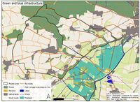
Blue and Green Infrastructure
- What are the major potential elements of a green/blue infrastructure network? Are these likely to change/disappear? Why is that?
Green infrastructure is a water management approach that recovers, protects and mimics the natural water cycle. This goal can be achieved through natural environment and engineered systems. 18.52% (1447 ha) of our area is forested. Only 26ha is in peatland. In the north we have a larger area of Freisinger Forst. This is a mixed stand of oak and beech (70% beech, 30% oak). Age of the forest is above 170 years for oak and above 150 years for beech. Forest was planted on former farmland, therefore this is human made forest, not natural. Beside this comprehensive forest area, we also count forest borders, smaller forest islands and hetches (69 ha). A large part of the area is covered by peatland. In its natural state, the moorland has a positive impact on the water cycle, as it retains flood waters and filters water. Unfortunately, the Freisinger Moos has been largely exploited in the past for peat harvesting, which has greatly altered the moor. The agricultural activity that still takes place on the moor today has lowered the water level, which is again not good from the point of view of the natural water cycle. Nevertheless, the situation in the marsh is improving and restoration is ongoing. The part of the area dedicated to nature protection is increasing, as various stakeholders are buying land for the compensation points system. The nature conservation areas improve the habitat possibilities of flora and fauna, which also have an impact on the natural water cycle through their activities (e.g. paludiculture).
Our area therefore has a number of potentials. The widespread road infrastructure (farm tracks, forest tracks, etc.) offers good opportunities for recreation. To make even better use of it, we should install some more benches, signposts, etc. Recreation areas could find place in already existing forest and field roads. The traffic load of these roads is small, so it is suitable for pedestrians and cyclists. These roads are not paved, so they are not suitable for some forms of recreation. However, care must be taken here not to overburden recreation in the forest and swamp area, as these areas are important for biodiversity. Biodiversity is very diverse, so it is important to preserve it and encourage its development and multiplication. This can be done by maintaining habitat conditions in their natural state and with revitalization of destroyed habitats back to their natural status. The area has many small streams and rivers. It is necessary to ensure that these remain in their natural course or that rivers that have already been artificially dammed are restored to their original state. This moderates the flow velocity, as the water does not flow forward as quickly as through canals, but is retained in the area.
On the other side, we have a lot of artificial pressure on the area. There are few big roads, which connect smaller settlements to each other. There are much smaller roads (forest and field roads), which are used for the purpose of maintenance of foresta and agricultural land. In the area there are few small villages. We need to ensure that settlements will not spread onto agricultural and natural land – preventing land use change. The proximity to the airport, settlements, road infrastructure (minor link roads, motorway) makes the area prone to noise and light pollution. Besides infrastructure there is one another important factor of impact in our area – agriculture. Due to the good soils, the northern part of the area is heavily used for agriculture, with very little uncultivated land. Agriculture uses fertilizers, which pollute the water. Since this is a hilly area soil erosion occurs. Soil is transported to the rivers nearby, which means water gets saturated with silt. One of the main rivers of soil transport in our area is Moosach. Beside this Moosach was already polluted by malachites (disinfectants) from fish farms nearby. Therefore water quality needs to be protected.
- You find my background material on green infrastructure in our reading list
- add 1-2 graphical representations to the image gallery, you can add more if you like
Natural and Artificial river structures
- Index.php?title=File:Your case green blue infrastructure2.jpg
add a caption

Water as a cultural space
Land use and water
- map the land uses along your water areas: settlements, infrastructure, agriculture, resource extraction, natural areas, energy production...
The hilly area consists of two watersheds. The Kleinbacherner ditch and the Sünzhausener ditch.The third part of our project area is the Freisinger Moos a fen. The catchment area of both watersheds is the Freisinger Moos. Settlements are spread over the hilly areas, whereby the two name-given settlements, Kleinbachern and Sünzhausen lying along the watershed's water axis. A few smaller villages are spread like Haxhausen and Pellhausen. Furthermore, there are individual hamlets, secluded farms and small residential areas. The infrastructure, especially the roads following along the water axis in order to connect the villages with the main road, whereby this main road separates the hilly area from the peatland. As can be seen on the historical maps, the street as a separation between the hills and the plain is old and exists at least since 1857. The location of the road is caused by the difficult soil conditions in the wet areas. Parallel to this road a high voltage transmission line crosses the whole area, to ensure the energy supply of the city of Freising. As well an additional line crosses the peatland.
The agricultural land use depends primarily on the soil and wetness conditions. In the hilly area the places with the best soil and steepness conditions are used more intensively for arable land use, whereby in the steep slopes the grassland usage is more common. A part of the hilly area is also covered by forests and small woody features such as hedges, bushes and scrubs. Natural areas are in general not given. Some parts of the forests and the peatland could still be considered as low managed. There is still more or less natural characteristic vegetation present. The Freisinger Moos is a landscape protection area and includes designated bird protection areas and flora-fauna habitat areas.
Forests provide additional services in the landscape. Besides recreational services, forests reduce emission and noise pollution, protect habitats and landscapes and general resources. Especially the peatland forests containing a historically valuable forest stock. Additional, forests play an important role for soil conservation and climate conservation.
The peatland is predominantly used as grassland with partial extensive pasture use. Despite the humid conditions in this area, drainage allows arable land use partly also intensive. The main area is used for hunting. Groundwater protection playes also an important role in the peatland. For that reason flowering areas are created that provides besides water protection based on the reduction of agricultural use also nature and habitat protection. Partly the peatland is used as compensation area for residential land, commercial areas and roads.
In the peatland area is also a peatland research station located. It is a test facility in the research project 'MOORuse' for the measurement of the CO2 outgassing of the rewetted fen soil with four planting variants in the Freising moss. This is fundamental research for an alternative wetland land use system like paludiculture. Also its contribution to climate mitigation, its environmental effects and profitability is investigated.
The peatland is also an important recreation area for the Freisinger inhabitants. The flat area invites you to walk and cycle. Horse riding trips are also made there.
- On the hills: The Hills were used mostly for agriculture on the sides and Woodlands on top. Woodlands were mostly coniferous (which year is that map?) - used for timber production.
- In the peatland: Freisinger Moos is a fen area, crossed by the river Moosach as the largest flowing waters. Coming from the Freising moss, the Moosach divides into several arms in the city area, some of which humans have artificially created for mills. This huge lowland moor complex was shaped for decades by the use of mowing pasture and peat pits.
- describe in particular the historical evolution of land use pattern, please make use of historical maps
In the first half of the 20th century there were massive interventions in the water balance. But as it was traditionally used extensively until the 1960s, the character of the Freisinger Moos was largely preserved. The landscape is characterized by small-scale peat cutting, litter meadows and a close juxtaposition of various wetland and wet meadows.
The Moosach river at first free is later in a canal. On the map from 1940 it is completely canalized but the process started long before.
The structural change in agriculture, especially since the 60th, has had drastic consequences for the Freisinger Moos. There was a large-scale intensification of land use and the forms of use that had become unprofitable, such as small-scale peat cutting, were abandoned. Willows and bushes started colonizing the no longer mown meadows and peat bogs.
For the last 20 years, the district of Freising and the municipality of Neufahrn bought up fallow sites and renaturalized them
- description evolution, status quo and driving forces, is the land use likely to change? Why is that? (approx 200 signs)
Despite massive interventions in the water balance, which occurred mainly in the first half of the 20th century, the character of the Freisinger Moos remained largely intact, as it was traditionally used extensively until the 1960s.However, the structural change in agriculture also had drastic consequences for the Freising moss. The large-scale intensification of land use, combined with the abandonment of unprofitable forms of use, such as the use of litter meadows to obtain litter, began to change the landscape and its habitats
In order to mitigate the climate change the role of peatland as carbon storage is increasing. That fact leads to the assumption that extension of nature reserve areas, extensive land use or alternative peatland use system like paludiculture might be implemented in the future. These benefit of carbon storage through the peat build up, based on rewetting actions of the drainaged peat areas. As side-effect natural peatland plant vegetation is artificially settled or spreads naturally again.
The main drivers of agricultural land use are the social acceptance, political framework and the change in agricultural subsidies.
- Conflit stronger - Population increase (so more food and space needed)? but not in moor -> more awareness
- Water and climate change - pronostic = less water => dangerous for the water balance - (hot summer dangerous for moor?)
- add 1-2 graphical representations to the image gallery, you can add more if you like
- Yourcase landuse1.jpg
add a caption
- Yourcase landuse2.jpg
add a caption
- Yourcase landuse3.jpg
add a caption
Cultural and spatial typologies of water areas
- Which spatial patterns have evolved in relation to your water areas?
The main villages are built along the rivers and brooks. As well the major roads follow along the brooks to the main street to Freising. Connections between the path and drainage water axis development in the peatland are discernible. A connection between temporary water conditions and path development is also recognizable. Caused by the wetness condition no settlements have been developed in the peatland area.
- What is the role of water areas within the overall urban morphology? (approx 200 signs)
The Moos is a place of leisure for the people of the city of Freising. They go there to enjoy the landscape and nature. The proximity to Freising and the easy accessibility gives it an important role.There are no villages in the Moos, the ground is too wet and unstable.The villages are situated on the hills, often along the brooks and rivers flowing to the Moosach and to the Moos. The villages do not have an interesting or important relation to those small rivers, they do not use them. The brooks are often buried under the villages or flow discreetly along the streets and between the fields??We can see that some streets are situated where the brook was in the center of the village, before it was buried. ???Water as source (drinking water) in the villages?
- add 1-2 graphical representations to the image gallery, you can add more if you like
- Index.php?title=File:Yourcase water space1.jpg
add a caption
- Index.php?title=File:Yourcase water space2.jpg
add a caption
- Index.php?title=File:Yourcase water space3.jpg
add a caption
Sacred spaces and heritage
- Which places/elements hold cultural value and to whom?
- You may add a map and some images, please also explain in your caption why these elements are valuable
- Your case sacredspace1.jpg
add a caption
- Your case sacredspace2.jpg
add a caption
- Your case sacredspace3.jpg
add a caption
Visual appearance and landscape narrative
- Which elements are essential for the landscape character?
The Freisinger Moos is a fen and spring fen area. Fens form in river lowlands and hollows at spring outlets. They grow only slightly in height and are interspersed with groundwater, spring water or seepage water up to the bog surface. Their vegetation is species-rich and consists mainly of reeds, rushes and mosses.
The landscape, characterized by small peat cuttings, scattered meadows and a close juxtaposition of different wet and wet meadows, offers habitat for a variety of plant and animal species typical of the fen.
- Has the landscape been painted or otherwise depicted, when and whom? Which elements are essential?
Fritz Halberg-Krauss through his work "Holzfäller im Freisinger Moos" (1942), he testifies the earlier forestry use of the Freisinger Moor landscape. The moss green colour scheme is typical of the natural moor vegetation.The flowing transition of the wet areas to shrubs and forest elements still points to the past only slightly by humans influenced nature and water elements of the landscape.
- Which narratives exist? Who has written about this landscape or depicted it in some way?
- You can add text and images
- Your case character1.jpg
add a caption
- Your case character2.jpg
add a caption
- Your case character3.jpg
add a caption
Water and People
Accessibility and usability
- Where are your water areas accessible, and where not? How strong are spatial obstacles preventing access?
- Who is using the spaces and how?
- Yourcase youraccessbilitymap.jpg
add a caption
- Yourcase usepatterns.jpg
add a caption
Community Mapping
What is to be mapped here?
- Social groups from within the community, for example the youth, kids, students, parents, the retired etc. Typically, these groups have specific needs, which you can also make explicit on the map. These people might not be organized in any way, but they are usually present in the context you are observing
- Local stakeholder groups: these groups are organized in one or the other way. They only exist within the community context you are observing. For example: the local community center, local churches, local interest groups, the landowners, small businesses and retailers
- External stakeholder groups are not necessarily present in the environment you are observing, but they may have strong stakes and interests. These can be local authorities, politicians, associations, care services etc.
- For each group, you may identify their needs, objectives, power and capacities
- You may also identify gaps and power conflicts
- Please try to redepict these elements in an integrated way and in relation to your water landscape. What is the relationship between these groups? Are they close or distanced from each other? Who is more powerful? Which voices are hardly heard? Do they have any shared concerns?
- Your case your community map1.jpg
add a caption
- Your case your community map2.jpg
add a caption
- Your case your community map3.jpg
add a caption
Possible Futures
- You can summarize your findings with a SWOT diagram and a DPSI(R) Model
- Link back to the Sustainable Development Goals: Which goals are at risk?
- What is your worst case scenario for this landscape?
- What is your best case scenario for this landscape?
- Present your scenarios in the form of a collage or sketch
- Add text and visuals
- Your case your spider diagram or dpsir model.jpg
explain your analysis briefly in the caption
- Your case yourworstcase visual.jpg
explain your worst case scenario briefly in the caption
- Your case yourbestcase visual.jpg
explain your best case scenario briefly in the caption
Collaborative Goal Setting
- Define strategic planning objectives based on the evaluation findings from your analysis
- Ideally, involve the community of your living labs into this process
- Link back to your original targets from section one and the Development Goals
- 150 words text contribution
Spatial Strategy and Transect
- translate your strategic goals into a vision
- develop a spatial translation of your vision
- exemplify your vision in the form of a transect with concrete interventions
- add map(s) and visualizations
- Your case spatial translaton vision.jpg
add caption here
- Your case transect.jpg
add caption here
- Your case transect detail1.jpg
add caption here
- Your case transect detail2.jpg
add caption here
From Theory of Change to Implementation
- For implementing your vision: Which partnerships are needed? Which governance model is required?
- Who needs to act and how? Draw and explain a change/process model/timeline
- Which resources are needed? On which assets can you build?
- add 150 words text and visuals

add caption here

add caption here


References
- give a full list of the references you have used for your case
Process Reflection
- Reflect in your intercultural and interdisciplinary team on the outcomes of your study
- Which limitations were you facing?
- What have you learnt from each other?
- What did you learn in the Living Labs?
- What would you do differently next time?
- You can also use diagrams/visuals
- 250 words text