Tartu Upstream WAVE Living Lab 2021: Difference between revisions
Razeen.nazar (talk | contribs) |
|||
| (48 intermediate revisions by 3 users not shown) | |||
| Line 11: | Line 11: | ||
{| align="right" width="400pt" style="background:Gainsboro; color:black" | {| align="right" width="400pt" style="background:Gainsboro; color:black" | ||
|- | |- | ||
| '''Area''' ||style="background:Lavender"| '' | | '''Area''' ||style="background:Lavender"| '' Emajogi River Upstream'' | ||
|- | |- | ||
| '''Place''' || style="background:Lavender"|'' | | '''Place''' || style="background:Lavender"|''Tartu'' | ||
|- | |- | ||
| '''Country''' || style="background:Lavender"|'' | | '''Country''' || style="background:Lavender"|''Estonia'' | ||
|- | |- | ||
| '''Topics''' || style="background:Lavender"|'' | | '''Topics''' || style="background:Lavender"|''Water as Cultural Space, Biodiversity, Rebirth of water history '' | ||
|- | |- | ||
| '''Author(s)''' || style="background:Lavender"|'' | | '''Author(s)''' || style="background:Lavender"|''Natalia, Kaled, Razeen'' | ||
|- | |- | ||
| colspan="3" align="center" style="background:silver"| [[File: | | colspan="3" align="center" style="background:silver"| [[File:Upstream Cover.jpeg|400px]] | ||
|- | |- | ||
| ||style="background:Lavender"| | | ||style="background:Lavender"| | ||
| Line 30: | Line 30: | ||
= Rationale = | = Rationale = | ||
*''Why do you think this case is relevant? What is your hypothesis considering the landscape challenges?'' | *''Why do you think this case is relevant? What is your hypothesis considering the landscape challenges?'' | ||
Tartu is second biggest city of Estonia with a lot of history which is strictly connected to the river. It has a rich nature surrounding shores of the river comparing with other European cities. The bigest challange will be finding a solution to preserve this natural area and preserving history surrounding the river. | |||
= Location and scope = | = Location and scope = | ||
| Line 42: | Line 42: | ||
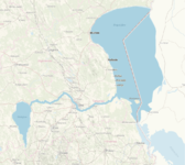
-Emajõgi is a 100 km long river that flows from Lake Võrtsjärv located in southern Estonia, through Tartu County into Lake Peipsi located on the east border. 10 km of it goes through the city of Tartu. | -Emajõgi is a 100 km long river that flows from Lake Võrtsjärv located in southern Estonia, through Tartu County into Lake Peipsi located on the east border. 10 km of it goes through the city of Tartu. | ||
-Emajõgi river is divided into 3 sections: | -Emajõgi river is divided into 3 sections: | ||
1) Upper course from Võrtsjärv to Kärevere bridge which is characterized by large, flat, and marshy areas and heavy meanders which are a part of Alam-Pedja Nature Reserve. The floodplain there doesn't have a defined floodplain, as the water can span several kilometers. | |||
2) Middle course from Kärevere to Kavastu through Tartu river has a straighter course and floodplain can be defined, the valley is mostly shallow which maximum depth of 10 m and width of 1-1,5 km (in Tartu it's narrowed to 800 m) | |||
3) Lower course of the river flows through Emajõe Suursoo characterized by swampy lowlands and is entering Lake Peipsi at Praga. | |||
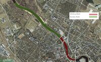
Half of the water feature in our living lab is artificial (canalized) river and the other half is natural with outdoor activities such as beaches & man-made wetlands. There is a small riverside bulwark located by the side of the river. | Half of the water feature in our living lab is artificial (canalized) river and the other half is natural with outdoor activities such as beaches & man-made wetlands. There is a small riverside bulwark located by the side of the river. | ||
Bodies of surface water are divided into watercourses (rivers, brooks and ditches) and stagnant water (lakes, ponds). | Bodies of surface water are divided into watercourses (rivers, brooks, and ditches) and stagnant water (lakes, ponds). | ||
Main floodplains and catchment areas are located outside of the city center on the western side of the living lab. Floodplain is heavily canalized and is covered by trees, which helps with | Main floodplains and catchment areas are located outside of the city center on the western side of the living lab. Floodplain is heavily canalized and is covered by trees, which helps with water redistribution. It allowed the city to regulate the river in the center and protect the city from flooding. | ||
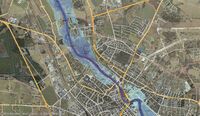
Water in Emajõgi river fluctuates between 1,2-2,6 m in a year and during summer it can cause floods. In the most extreme situations the water rises till 3,75 m. Emajõgi River rises its level after winter. Because of it Tartu struggles with the water level often. When Emajõgi in Tartu rises 2,54 m above the station schedule zero is critering as a high inland water lever alter. Water level exceeded by 0,5-1 m happens every ten years and more than 1m happens every 50 years. | Water in the Emajõgi river fluctuates between 1,2-2,6 m in a year and during summer it can cause floods. In the most extreme situations, the water rises till 3,75 m. Emajõgi River rises its level after winter. Because of it, Tartu struggles with the water level often. When Emajõgi in Tartu rises 2,54 m above the station schedule zero is critering as a high inland water lever alter. Water level exceeded by 0,5-1 m happens every ten years and more than 1m happens every 50 years. | ||
The drop from Võrtsjärv to Peipsi is little so it sometimes results | The drop from Võrtsjärv to Peipsi is little so it sometimes results in a change of the water flow in the river during winter when the surface runoff in the eastern area is bigger. The reverse flow is slow, 7 cm/s. | ||
Most of the living lab adjacents with natural areas and buildings are remoted from the river. Residential areas on the southern side of the living lab are endangered by the water fluctuation during extreme events. | Most of the living lab adjacents with natural areas and buildings are remoted from the river. Residential areas on the southern side of the living lab are endangered by the water fluctuation during extreme events. | ||
Even without heavy snow it’s not possible to use passages under the Kroonuaia bridge. This event occurred in 2020, 2010, 2008 and 1999. | Even without heavy snow, it’s not possible to use passages under the Kroonuaia bridge. This event occurred in 2020, 2010, 2008, and 1999. | ||
In may 1867 record flood in Tartu took place. | In may 1867 record flood in Tartu took place. | ||
In 2019 Crisis | In 2019 Crisis Committee discussed the flood risk during spring. and from November that year, special staff training took place that would provide better water and sewage services | ||
*''add 2-3 graphical representations to the image gallery, you can add more if you like'' | *''add 2-3 graphical representations to the image gallery, you can add more if you like'' | ||
<gallery caption=" " widths="200px" heights="150px" perrow="5"> | <gallery caption=" " widths="200px" heights="150px" perrow="5"> | ||
SavedMap20210427105111556.png|Flow of Emajõgi | |||
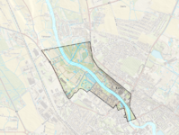
Woda_elementy.png|Water systems in the living lab | |||
Upstream tartu 1.jpg|Tartu flood zones | |||
<gallery> | |||
</gallery> | </gallery> | ||
== Water as a living space == | == Water as a living space == | ||
*''Which habitats can be found in and along the water areas of your area?'' | *''Which habitats can be found in and along the water areas of your area?'' | ||
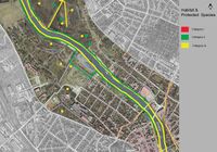
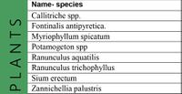
In the Protected Species map, it is possible to see the area occupied by protected species in all three Categories. Mostly the upper stream of the river is with category II and category iii species. A Large Number of trees like Quercus robur, European ash, and green lawns can be seen in line with the river. While comparing the past timeline the urban river area had a large number of habitat species as compared to the now. Cat 2 species which are in | |||
danger of disappearance, whose population has been reduced as a result of human activity and urban development. | |||
*''How is the water quality in your water areas?'' | *''How is the water quality in your water areas?'' | ||
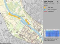
The water quality is relatively good as there are 2-3 ditches from natural lands which do not pollute the river and there aren't any industries allowed and that is why it’s allowed to swim in the river. There are three public swimming areas in Tartu city, Two spots are located in upstream of the river ( Emajõgi Beaches) it is called Emajõe vabaujula in Tähtvere city district on the right bank of the river and Emajõe linnaujula. The quality of the bathing water in this area is very good. | |||
*''Which areas are still natural, which are urbanised/artificial?'' | *''Which areas are still natural, which are urbanised/artificial?'' | ||
The upper part of our living lab is natural with some floodplains and man-made wetland. The lower part is artificial (canalized) with urban life (parks & building). | |||
*''Are the rivers permeable for fish or blocked by artificial elements?(approx 200 signs)'' | *''Are the rivers permeable for fish or blocked by artificial elements?(approx 200 signs)'' | ||
There are not any blocks (artificial or natural) that prevent fishes from moving along the river in any direction. | |||
*''add 1-2 graphical representations to the image gallery, you can add more if you like'' | *''add 1-2 graphical representations to the image gallery, you can add more if you like'' | ||
<gallery caption=" " widths="200px" heights="150px" perrow="5"> | <gallery caption=" " widths="200px" heights="150px" perrow="5"> | ||
File:Upstream_Tartu_Natural-Artifical_River.jpg|''Natural & Artifical River'' | File:Upstream_Tartu_Natural-Artifical_River.jpg|''Natural & Artifical River'' | ||
File: | File:Habitat Protected Species.jpg|''Habitat Protected Species Map'' | ||
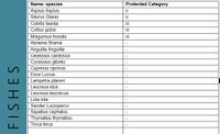
File: | File:Fishesh.jpg|''Fishes present in the upstream of Emajõgi'' | ||
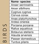
File:BIRDS.jpg|''Birds variety in the upstream of Emajõgi'' | |||
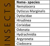
File:INSECTS.jpg|''Insect variety in the upstream of Emajõgi'' | |||
File:Plants.JPG|''Plant diversity in the upstream of Emajõgi'' | |||
File:Water map.JPG|''Water Quality and water Activites'' | |||
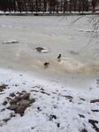
File:Ducks Frozen Urban River side.jpg|''Ducks on the frozen river Emajõgi'' | |||
</gallery> | </gallery> | ||
| Line 122: | Line 138: | ||
*''map the land uses along your water areas: settlements, infrastructure, agriculture, resource extraction, natural areas, energy production...'' | *''map the land uses along your water areas: settlements, infrastructure, agriculture, resource extraction, natural areas, energy production...'' | ||
*''describe in particular the historical evolution of land use pattern, please make use of historical maps'' | *''describe in particular the historical evolution of land use pattern, please make use of historical maps'' | ||
The River town Tartu was first declared in 1918. River Emajõgi has served and Sustained the city of Tartu Throughout history. The city is also known as the Athens of Emajõgi River. Where people here actively shaped its form and settlements through generations. The Castle Toome was dated from the 5th century of settlers of Kunda culture. | |||
During the beginning of the First World War, the city was controlled by German troops, but already in the year 1919, Estonia took back Tartu up until the occupation by the Soviet Union. In the years 1944-1991. Throughout history, River Emajõgi was used as a waterway, trade way, and for fishing and Public Bathing. | |||
*''description evolution, status quo and driving forces, is the land use likely to change? Why is that? (approx 200 signs)'' | *''description evolution, status quo and driving forces, is the land use likely to change? Why is that? (approx 200 signs)'' | ||
River Emajõgi is the important character of Tartu, fragmented with Cultural identity. People started using the river for trading, fishing and Bathing, due to this Settlements started to fall closer to the riverside. A comprehensive plan for Tartu completed in 1956. | |||
Soviet-era Planning, Changed the Dynamics and character of the blue space. Suplinn is the Oldest Wooden Architecture Settlement and Historical district of Tartu, which is surviving from the 18th century, which lies to the river. Suplinn land use Structure with 40 percent of the land was reserved for housing, 30 percent for university buildings, 25 percent for greenspace, and 5 percent for public rights-of-way. A green corridor is planned along the Emajõgi River and sports facilities in the north of the district. The only building to be preserved is a public bath (in Emajõgi Street). From this, Land Use evolution started expanding along the riverside. Bridges played an important role in developing the land on both sides of the river. | |||
*''add 1-2 graphical representations to the image gallery, you can add more if you like'' | *''add 1-2 graphical representations to the image gallery, you can add more if you like'' | ||
<gallery caption=" " widths="200px" heights="150px" perrow="5"> | <gallery caption=" " widths="200px" heights="150px" perrow="5"> | ||
File: | File:Tartu settlement Pattern Arial.jpg|''A basic Arial view of Settlement patterns in past and present'' | ||
File: | File:Tartu history River side Views.jpg|''Transformation of 90's River Emajõgi'' | ||
File: | File:Suplinn Settlements Map.jpg|''Soviet Times Supilinn and Now'' | ||
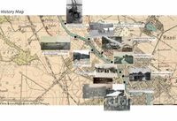
File:History tartu.JPG| ''Past Activites at River Emajõgi '' | |||
</gallery> | </gallery> | ||
== Cultural and spatial typologies of water areas == | == Cultural and spatial typologies of water areas == | ||
*''Which spatial patterns have evolved in relation to your water areas?'' | *''Which spatial patterns have evolved in relation to your water areas?'' | ||
While comparing past Timeline River Emajõgi plays an important role in the development of settlement patterns. The Emajõgi River has the highest elevated level in the urban part. Which adjoins most building typology like heritage, public, private buildings. This busiest river on the side has urban parks, recreational areas, blue and green hotspots for Interactions. with various daily activities involved. The ground cove-red with bog soil that balances the growth of vegetation around the river. The landscape ecology of the Emajõgi river is wrapped up with Various Trees and Green Spaces. The Main roads and bridges serve as the connecting system between the river and urban settlement areas. Pedestrians alongside the river help to maximize its usefulness. | |||
*''What is the role of water areas within the overall urban morphology?'' (approx 200 signs)'' | *''What is the role of water areas within the overall urban morphology?'' (approx 200 signs)'' | ||
Water Spaces have an important role in the process of formation and transformation of urban spaces. It also helps to identify the past history and understand the concepts behind settlements patterns and planning. The urban river area had a large number of habitat species in the past as compared to now. The Development of urban settlements causes a threat to the ecosystem. Category 2 species which are in danger of disappearance, whose population has been reduced as a result of human activity, Although the city is well balanced with Ecosystem. The usage of river area is more by people which benefits Huma the health through interaction with nature. | |||
*''add 1-2 graphical representations to the image gallery, you can add more if you like'' | *''add 1-2 graphical representations to the image gallery, you can add more if you like'' | ||
<gallery caption=" " widths="200px" heights="150px" perrow="5"> | <gallery caption=" " widths="200px" heights="150px" perrow="5"> | ||
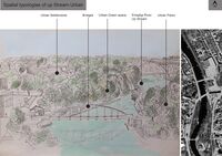
File: | File:Spatial typologies Tartu Up Stream Urban.jpg|''Spatial typologies of Tartu Up Stream Urban'' | ||
File: | File:Natural Track Emajõgi.jpg|''Natural River side track '' | ||
File: | File:Boatyard View Emajõgi.jpg|''Boatyard view Emajõgi'' | ||
</gallery> | </gallery> | ||
== Sacred spaces and heritage == | == Sacred spaces and heritage == | ||
*''Which places/elements hold cultural value and to whom?'' | *''Which places/elements hold cultural value and to whom?'' | ||
Whole plan of the city is connected with the river. Main square and town hall are located perpendicular to Emajõgi and in a line with Kaarsild bridge, where in the past Stone Bridge existed. Currently there is a statue standing next to the new bridge which reminds people of this heritage. In the center there are also located parks that are adjacent to the river. They were created on the place of buildings which were destroyed in 1941 and 1944 by Soviets. As Estonia gained independance in 1991 buildings there were never rebuild and parks are compensanting this, but at the same time they bring a great value to thi city. | |||
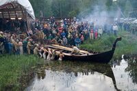
For everyday life locals come to the river to walk and ride through the boulevards. In the place of Tartu Pools there is Emajõe Lodjakoda located which is not only popular space for locals, but also for tourists. As it's a space of barge’s house there were multiple boats created and fixed there, firstly as a voluntary work and now as a well known institution in Estonia. Cotnemporary architecture is fitting with the river creating a space for workshopps. A boat located in front of the building reminds of sailing past of the river. | |||
Not only places by the riverside are holding cultural value, but actions hapening on the water itselfs are greatly important. As in the past there was culture of sailing it is planned to restore this value. By 2024 there should be boat excrusions going from Võrtsjärv lake to Peipus lake connected to the program ''Reclaiming The River Emajõgi And The Great Lakes''. | |||
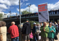
Emajõgi holds a great part in life of Tartu citizens. In 2018 the biggest public outcry since Estonia regained independance took place against industrial invasion on the riverside of Emajõgi. It redefined Tartu and proved importance of this space. | |||
* ''You may add a map and some images, please also explain in your caption why these elements are valuable'' | * ''You may add a map and some images, please also explain in your caption why these elements are valuable'' | ||
<gallery caption=" " widths="200px" heights="150px" perrow="5"> | <gallery caption=" " widths="200px" heights="150px" perrow="5"> | ||
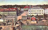
Tartu_Vaade_kivisillalt_raekojale,_c_1910.jpg|City center with Stone Bridge in 1910 http://www.vykortsmuseum.se/old-postcards/101010.html | |||
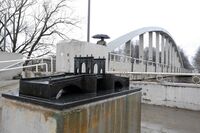
Stone_Bridge.jpg|Cast iron monument presenting Stone Bridge which was destroyed during II WW , but still is a strong symbol of Tartu https://arvamus.postimees.ee/3970703/postimees-1995-aastal-tartu-kivisilla-hind-on-vahenenud-ule-kuue-korra | |||
Turm_vette_jc3bcri_laan.jpg|Viking ship lounched in 2009 by Emajõe Lodjakoda https://mudonourfeet.wordpress.com/2013/05/19/emajoe-lodjakoda/ | |||
Protest.png|Public outcry regarding to industrial invasion on the riverside https://news.err.ee/832812/gallery-thousands-protest-in-tartu-in-support-of-emajogi-river | |||
</gallery> | </gallery> | ||
| Line 162: | Line 195: | ||
*''Which narratives exist? Who has written about this landscape or depicted it in some way?'' | *''Which narratives exist? Who has written about this landscape or depicted it in some way?'' | ||
Emajõgi is a irreversible part of a city and holds a great part in everyones heart. As the legends are saying Tartu was born out of the Mother River. She created the rythm of which city is living. Emajõgi is loved and respected but at the same time she often brings destruction by flooding the streets, which are cousing huge loses. | |||
Narrative about the river presents the life that is happening in its surrounding. Showing the river as a conector of the people and how much their life is connected to Emajogi - how it flows with all the actions floating around her. Idea like this is presented in a poem Tartu 'When It Sizzle' by Remo Gramigna. | |||
<gallery caption=" " widths="200px" heights="150px" perrow="5"> | <gallery caption=" " widths="200px" heights="150px" perrow="5"> | ||
<gallery> | <gallery> | ||
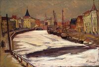
VIllem_Ormisson_View_of_Tartu.jpg|Ormisson View of Tartu 1940 | TKM_0793M,_Talvine_Tartu_Emajõega,_Nikolai_Triik.jpg|Takvine Tartu Emajoega by Nikolai Triik, 1935 | ||
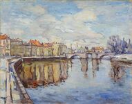
Tartu_pocztówka_1968_A_Kutt.jpg|Postcard by A.Kutt 1968 | VIllem_Ormisson_View_of_Tartu.jpg|Ormisson View of Tartu, 1940 | ||
Tartu_pocztówka_1968_A_Kutt.jpg|Postcard by A.Kutt, 1968 | |||
Pool.jpg|Tartu Swimmingpool by Varmo Pirk, 1940 | |||
</gallery> | |||
</gallery> | </gallery> | ||
| Line 182: | Line 216: | ||
File:Upstream_Tartu_Access_1.jpg|''Access Map With the uses'' | File:Upstream_Tartu_Access_1.jpg|''Access Map With the uses'' | ||
File:Upstram_Tartu_Access_2.jpg|''Landscape Character assessment (LCA)'' | File:Upstram_Tartu_Access_2.jpg|''Landscape Character assessment (LCA)'' | ||
File:Characters Location.JPG|''Landscape Character Areas'' | |||
</gallery> | </gallery> | ||
| Line 220: | Line 255: | ||
<gallery caption=" " widths="500px" heights="200px" perrow="5"> | <gallery caption=" " widths="500px" heights="200px" perrow="5"> | ||
File: | File:Community Map.jpg|''Local Stakeholder Maping'' | ||
</gallery> | </gallery> | ||
| Line 232: | Line 265: | ||
* ''Present your scenarios in the form of a collage or sketch'' | * ''Present your scenarios in the form of a collage or sketch'' | ||
* ''Add text and visuals'' | * ''Add text and visuals'' | ||
Problem that is common for our values which are biodiversity and haritage preservation is habitat reduction and loss of history. It can be coused by people losing connection with the river. In our Living Lab strong relation of flora, fauna and people is very well visable. Losing the habitat will couse reduction of native speciel and it will couse a lot of changes in urban ecostystem of Tartu. To preserve good relationship of history, nature and people we propose to create green pockets and recall activities of the past. It would bring back people to their roots, connect with nature more and appriciate this great working urban ecosystem which welcomed nature. | |||
<gallery caption=" " widths="500px" heights="200px" perrow="5"> | <gallery caption=" " widths="500px" heights="200px" perrow="5"> | ||
DPSI Model.JPG|DPSI(R) Model | |||
As Tartu is very lucky with its relationship with Emajogi river our most optimistic scenario is already happening. People and nature can interact with each other. The only thing that is missing is cultural background and understanding of this place. Understanding how envirmoent like this is and should be important in every other city as well. | |||
</gallery> | |||
Scenario.png|Future scenarios | |||
File:your case_yourbestcase visual.jpg|''explain your best case scenario briefly in the caption'' | File:your case_yourbestcase visual.jpg|''explain your best case scenario briefly in the caption'' | ||
</gallery> | </gallery> | ||
| Line 244: | Line 284: | ||
*''Link back to your original targets from section one and the [http://www.un.org/sustainabledevelopment/sustainable-development-goals/Sustainable Development Goals]'' | *''Link back to your original targets from section one and the [http://www.un.org/sustainabledevelopment/sustainable-development-goals/Sustainable Development Goals]'' | ||
* ''150 words text contribution'' | * ''150 words text contribution'' | ||
The current state of our living lab nature wise is really good. We are not struggling with lack of activities, we have multiple biodiverse, green areas, clean water and we should preserve it. What makes our area special is the amount of history that was built around the river. Emajogi carries a huge part of the cultural heritage of Tartu. Our goal is to inform our target group about the importance of this kind of urban landscape which is well connected with the river environment. | |||
Our assumptions agree with Goals of Susitainable Development which should be adopted by United Nations Member States. We focus on : | |||
* sustaining clean water in our area by preventing further distructions | |||
* creating sustainable city by preserving water-resilant landscape | |||
* responsible consuption and production by creating low-impact activities for residence that could help them understand better importance of their landscape | |||
* protect water life and life on land in urban enviroment by not invading natural landscape | |||
* proposing partnerships of stakeholders to create stronger communities around the river | |||
= Spatial Strategy and Transect = | = Spatial Strategy and Transect = | ||
| Line 250: | Line 299: | ||
*''exemplify your vision in the form of a transect with concrete interventions'' | *''exemplify your vision in the form of a transect with concrete interventions'' | ||
*''add map(s) and visualizations'' | *''add map(s) and visualizations'' | ||
Looking back at history we can see that Tartu actually developed even though the landscape river ‘reversed’. Process of this deconstruction of the city was a positive thing for the relationship with the river. We can educate people about the importance of this relationship by showing how it changed in the last centuries. We can achieve it by proposing participating in the activities that were common in the past which involved the Emajogi river. | |||
To rediscover river landscape we propose to invite people on the journey of Past Tartu and introduce them to the history of the city. We can achieve it by following activities involving river which were common for their ancestors. | |||
We want to create an educational trail (2) of different kinds of activities. Some of them would be seasonal, some of them would need special infrastructure, but all of them will not invade the natural landscape of the river. Starting point of the trail would take place in the city. There would be some cameras (1) located all over the park and looking at the lense you are able to see tartu of the past, and relive this story. You are going to be able to see park covered by buildings and how people interacted with the river when the situation looked like this. As Tartu is located in the north and harsh winters are a reality we proposed winter activities which also have taken place in the past already. One of them would Ski Race and Horse Sledging (3) which would take place from historical location of Stone Bridge (Kaarsild) to Turusild which is a bridge located further north. Water Party and Barrel Jumping (4) would take place text to the Sport Center so they can supervise those activities, as equipment is needed for these. West side of the river is a popular fishing spot. TO connect people more to this heritage and educate about the importance of preserving river we propose to create workshops for kids, where they could fish their own fish and later eat them by preparing them at the fireplace. In the same place Fish Museum (5) could be located as well so you people can get educated about fauna and flora of the river. At Emajõe Lodjakoda Ice Cutting event could take place during winter (6). Beach nearby would be a starting point for a Water Festival (7) which would be continued after years of break. Beach Football (8) will take place at Tartu Beach and it would involve University students. | |||
We want to rediscovered already man made areas and preserve all the existing greenery (9). | |||
<gallery caption=" " widths="500px" heights="200px" perrow="1"> | <gallery caption=" " widths="500px" heights="200px" perrow="1"> | ||
File: | File:Msp wave-Recovered.jpg| Map Showing proposed historical activities around our living lab. The main aim is to bring back the history and protect the existing Green pockets | ||
File:Historical Activities.JPG| | |||
File: | |||
</gallery> | </gallery> | ||
| Line 263: | Line 318: | ||
*''Which resources are needed? On which assets can you build?'' | *''Which resources are needed? On which assets can you build?'' | ||
*''add 150 words text and visuals'' | *''add 150 words text and visuals'' | ||
For implementing our vision it is necessary to create relationships with stakeholders like schools, universities, kindergartens to create strong communities around the river. Additionally to create recreation spots by the river to recall history it would be good to make connections with Sport Clubs so it can supervise water activities. As history is a strong part of our project, collaboration with Estonian National Museum could be beneficial, as they can provide knowledge and resources to present idea of showing Tartu of the past. | |||
<gallery caption=" " widths="500px" heights="200px" perrow="1"> | <gallery caption=" " widths="500px" heights="200px" perrow="1"> | ||
File: | File:Community Map.jpg|''Local Stakeholders '' | ||
</gallery> | </gallery> | ||
== References == | == References == | ||
* '' | * ''https://www.maaamet.ee/et'' | ||
* ''https://ajapaik.ee/photo/31644/tartu-emajogi/'' | |||
* ''https://www.muis.ee/museaalview/2190254'' | |||
* ''https://www.arcgis.com/apps/MapJournal/index.html?appid=7ae5364a9d6e4b70a7f181308c738776#:~:text=All%20of%20the%20drinking%20water,level%20tends%20to%20be%20high.'' | |||
* ''https://www.atlasobscura.com/places/supilinn-the-soup-town'' | |||
* ''https://avibase.bsc-eoc.org/checklist.jsp?region=EEta&list=howardmoore'' | |||
= Process Reflection = | = Process Reflection = | ||
| Line 281: | Line 341: | ||
*''250 words text'' | *''250 words text'' | ||
Coming from different backgrounds it was interesting to see different ways of working on this project. We have learned how to share tasks and explain our ideas without actually seeing each other. Even though it takes longer time to discuss projects online we have always found a way to communicate and to came to similar conclusions. We also got much closer to water landscape we live near by today and make quicker observations and conclusions while spending time by the river. We understand what is working and not working in this landscape. As for pandemic we could not involve communities into the projects we were thinking of. Observing Living Lab was a very interesting experience, as we are not originally from Estonia. It was Surprising to see how well they manage the river in the city and how big is community showing interest in this subject. It's inspiring to see such a well-working environment. Additionally it was interesting to learn more about the history of our Living Lab and see how the relationship with the river changed and got preserved in some ways. We understand that our Living Lab is special because of the amount of layers that is preserving: from well maintained environment to very rich history background. Next time we would spend more time on consulting our ideas and discussing them more often, as with this we always got some new ideas to implement. | |||
---- | ---- | ||
[[Category:WAVE Case Study 2021]] | [[Category:WAVE Case Study 2021]] | ||
[[Category:WAVE Case Study]] | [[Category:WAVE Case Study]] | ||
Latest revision as of 17:18, 27 June 2021
>>>back to working groups overview
| Area | Emajogi River Upstream | |
| Place | Tartu | |
| Country | Estonia | |
| Topics | Water as Cultural Space, Biodiversity, Rebirth of water history | |
| Author(s) | Natalia, Kaled, Razeen | |

| ||
Rationale
- Why do you think this case is relevant? What is your hypothesis considering the landscape challenges?
Tartu is second biggest city of Estonia with a lot of history which is strictly connected to the river. It has a rich nature surrounding shores of the river comparing with other European cities. The bigest challange will be finding a solution to preserve this natural area and preserving history surrounding the river.
Location and scope
You can edit this map with the map editor
Water as a natural system
Geomorphology, typologies and dynamics of water areas
-Emajõgi is a 100 km long river that flows from Lake Võrtsjärv located in southern Estonia, through Tartu County into Lake Peipsi located on the east border. 10 km of it goes through the city of Tartu.
-Emajõgi river is divided into 3 sections:
1) Upper course from Võrtsjärv to Kärevere bridge which is characterized by large, flat, and marshy areas and heavy meanders which are a part of Alam-Pedja Nature Reserve. The floodplain there doesn't have a defined floodplain, as the water can span several kilometers.
2) Middle course from Kärevere to Kavastu through Tartu river has a straighter course and floodplain can be defined, the valley is mostly shallow which maximum depth of 10 m and width of 1-1,5 km (in Tartu it's narrowed to 800 m)
3) Lower course of the river flows through Emajõe Suursoo characterized by swampy lowlands and is entering Lake Peipsi at Praga.
Half of the water feature in our living lab is artificial (canalized) river and the other half is natural with outdoor activities such as beaches & man-made wetlands. There is a small riverside bulwark located by the side of the river. Bodies of surface water are divided into watercourses (rivers, brooks, and ditches) and stagnant water (lakes, ponds).
Main floodplains and catchment areas are located outside of the city center on the western side of the living lab. Floodplain is heavily canalized and is covered by trees, which helps with water redistribution. It allowed the city to regulate the river in the center and protect the city from flooding.
Water in the Emajõgi river fluctuates between 1,2-2,6 m in a year and during summer it can cause floods. In the most extreme situations, the water rises till 3,75 m. Emajõgi River rises its level after winter. Because of it, Tartu struggles with the water level often. When Emajõgi in Tartu rises 2,54 m above the station schedule zero is critering as a high inland water lever alter. Water level exceeded by 0,5-1 m happens every ten years and more than 1m happens every 50 years. The drop from Võrtsjärv to Peipsi is little so it sometimes results in a change of the water flow in the river during winter when the surface runoff in the eastern area is bigger. The reverse flow is slow, 7 cm/s.
Most of the living lab adjacents with natural areas and buildings are remoted from the river. Residential areas on the southern side of the living lab are endangered by the water fluctuation during extreme events. Even without heavy snow, it’s not possible to use passages under the Kroonuaia bridge. This event occurred in 2020, 2010, 2008, and 1999. In may 1867 record flood in Tartu took place. In 2019 Crisis Committee discussed the flood risk during spring. and from November that year, special staff training took place that would provide better water and sewage services
- add 2-3 graphical representations to the image gallery, you can add more if you like
Water as a living space
- Which habitats can be found in and along the water areas of your area?
In the Protected Species map, it is possible to see the area occupied by protected species in all three Categories. Mostly the upper stream of the river is with category II and category iii species. A Large Number of trees like Quercus robur, European ash, and green lawns can be seen in line with the river. While comparing the past timeline the urban river area had a large number of habitat species as compared to the now. Cat 2 species which are in danger of disappearance, whose population has been reduced as a result of human activity and urban development.
- How is the water quality in your water areas?
The water quality is relatively good as there are 2-3 ditches from natural lands which do not pollute the river and there aren't any industries allowed and that is why it’s allowed to swim in the river. There are three public swimming areas in Tartu city, Two spots are located in upstream of the river ( Emajõgi Beaches) it is called Emajõe vabaujula in Tähtvere city district on the right bank of the river and Emajõe linnaujula. The quality of the bathing water in this area is very good.
- Which areas are still natural, which are urbanised/artificial?
The upper part of our living lab is natural with some floodplains and man-made wetland. The lower part is artificial (canalized) with urban life (parks & building).
- Are the rivers permeable for fish or blocked by artificial elements?(approx 200 signs)
There are not any blocks (artificial or natural) that prevent fishes from moving along the river in any direction.
- add 1-2 graphical representations to the image gallery, you can add more if you like
Blue and Green Infrastructure
- What are the major potential elements of a green/blue infrastructure network? Are these likely to change/disappear? Why is that?
In the past the area was covered with residential buildings, but as an effect of WWII the area got demolished. As result of it there are plans to change it from grey structure to green structure and some blue structure to prevent it from flooding.
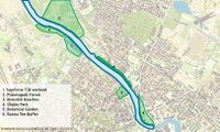
Green/Blue structure
Supilinna Tiik wetland
This is a man-made wetland on the western bank of the river and it’s made for preventing flooding into the city of Tartu
Püsietupaik Forest
It’s a natural protected untouchable mixed forest with only some hiking trails is located on the eastern bank of the river. Endangered species are also protected in protected areas and conservation areas, but in addition to the species protection objectives, there are also wider objectives - protecting endangered communities, preserving, protecting, restoring, researching or introducing nature. As a rule, the area of protected areas and conservation areas is larger than in permanent habitats.
Roositiik beaches
The beach is located on the western bank of the Emajõgi River, there is a sandy beach for sunbathing. There are various attractions for children: swings, climbing equipment, a slide and, a basketball basket. During the summer months, the Coast Guard also works during the day.
Ülejõe Park
This park was made after WWII as a green buffer from the urbanized part of Tartu city which has a lot of memorial monuments such as Hugo Treffner, Friedebert Tuglas, a sculpture group to celebrate the birth of the 100,000th Tartu resident, and memorial stone in honor of the first Estonian general song festival
Botanical Garden of the University of Tartu
The botanical garden is located on the western bank of the river, the area for growing monocots was re-designed into a free-shaped one at the beginning of the 1990s. The most rich-in-species groupings comprise the family Liliaceae (genera Tulipa, Allium, Fritillaria, Ornithogalum), the Iris family, the Orchid family, families Gramineae, Cyperaceae, Araceae.
Ranna Tee Buffer
It’s a buffer of Pine trees which is located in the eastern part of the Emajõgi River. It has some recreational activities such as musical concerts, canoeing launching areas.
- add 1-2 graphical representations to the image gallery, you can add more if you like
Water as a cultural space
Land use and water
- map the land uses along your water areas: settlements, infrastructure, agriculture, resource extraction, natural areas, energy production...
- describe in particular the historical evolution of land use pattern, please make use of historical maps
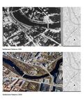
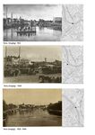
The River town Tartu was first declared in 1918. River Emajõgi has served and Sustained the city of Tartu Throughout history. The city is also known as the Athens of Emajõgi River. Where people here actively shaped its form and settlements through generations. The Castle Toome was dated from the 5th century of settlers of Kunda culture. During the beginning of the First World War, the city was controlled by German troops, but already in the year 1919, Estonia took back Tartu up until the occupation by the Soviet Union. In the years 1944-1991. Throughout history, River Emajõgi was used as a waterway, trade way, and for fishing and Public Bathing.
- description evolution, status quo and driving forces, is the land use likely to change? Why is that? (approx 200 signs)
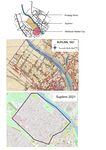
River Emajõgi is the important character of Tartu, fragmented with Cultural identity. People started using the river for trading, fishing and Bathing, due to this Settlements started to fall closer to the riverside. A comprehensive plan for Tartu completed in 1956. Soviet-era Planning, Changed the Dynamics and character of the blue space. Suplinn is the Oldest Wooden Architecture Settlement and Historical district of Tartu, which is surviving from the 18th century, which lies to the river. Suplinn land use Structure with 40 percent of the land was reserved for housing, 30 percent for university buildings, 25 percent for greenspace, and 5 percent for public rights-of-way. A green corridor is planned along the Emajõgi River and sports facilities in the north of the district. The only building to be preserved is a public bath (in Emajõgi Street). From this, Land Use evolution started expanding along the riverside. Bridges played an important role in developing the land on both sides of the river.
- add 1-2 graphical representations to the image gallery, you can add more if you like
Cultural and spatial typologies of water areas
- Which spatial patterns have evolved in relation to your water areas?
While comparing past Timeline River Emajõgi plays an important role in the development of settlement patterns. The Emajõgi River has the highest elevated level in the urban part. Which adjoins most building typology like heritage, public, private buildings. This busiest river on the side has urban parks, recreational areas, blue and green hotspots for Interactions. with various daily activities involved. The ground cove-red with bog soil that balances the growth of vegetation around the river. The landscape ecology of the Emajõgi river is wrapped up with Various Trees and Green Spaces. The Main roads and bridges serve as the connecting system between the river and urban settlement areas. Pedestrians alongside the river help to maximize its usefulness.
- What is the role of water areas within the overall urban morphology? (approx 200 signs)
Water Spaces have an important role in the process of formation and transformation of urban spaces. It also helps to identify the past history and understand the concepts behind settlements patterns and planning. The urban river area had a large number of habitat species in the past as compared to now. The Development of urban settlements causes a threat to the ecosystem. Category 2 species which are in danger of disappearance, whose population has been reduced as a result of human activity, Although the city is well balanced with Ecosystem. The usage of river area is more by people which benefits Huma the health through interaction with nature.
- add 1-2 graphical representations to the image gallery, you can add more if you like
Sacred spaces and heritage
- Which places/elements hold cultural value and to whom?
Whole plan of the city is connected with the river. Main square and town hall are located perpendicular to Emajõgi and in a line with Kaarsild bridge, where in the past Stone Bridge existed. Currently there is a statue standing next to the new bridge which reminds people of this heritage. In the center there are also located parks that are adjacent to the river. They were created on the place of buildings which were destroyed in 1941 and 1944 by Soviets. As Estonia gained independance in 1991 buildings there were never rebuild and parks are compensanting this, but at the same time they bring a great value to thi city. For everyday life locals come to the river to walk and ride through the boulevards. In the place of Tartu Pools there is Emajõe Lodjakoda located which is not only popular space for locals, but also for tourists. As it's a space of barge’s house there were multiple boats created and fixed there, firstly as a voluntary work and now as a well known institution in Estonia. Cotnemporary architecture is fitting with the river creating a space for workshopps. A boat located in front of the building reminds of sailing past of the river. Not only places by the riverside are holding cultural value, but actions hapening on the water itselfs are greatly important. As in the past there was culture of sailing it is planned to restore this value. By 2024 there should be boat excrusions going from Võrtsjärv lake to Peipus lake connected to the program Reclaiming The River Emajõgi And The Great Lakes. Emajõgi holds a great part in life of Tartu citizens. In 2018 the biggest public outcry since Estonia regained independance took place against industrial invasion on the riverside of Emajõgi. It redefined Tartu and proved importance of this space.
- You may add a map and some images, please also explain in your caption why these elements are valuable
City center with Stone Bridge in 1910 http://www.vykortsmuseum.se/old-postcards/101010.html
Cast iron monument presenting Stone Bridge which was destroyed during II WW , but still is a strong symbol of Tartu https://arvamus.postimees.ee/3970703/postimees-1995-aastal-tartu-kivisilla-hind-on-vahenenud-ule-kuue-korra
Viking ship lounched in 2009 by Emajõe Lodjakoda https://mudonourfeet.wordpress.com/2013/05/19/emajoe-lodjakoda/
Public outcry regarding to industrial invasion on the riverside https://news.err.ee/832812/gallery-thousands-protest-in-tartu-in-support-of-emajogi-river
Visual appearance and landscape narrative
- Which elements are essential for the landscape character?
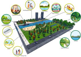
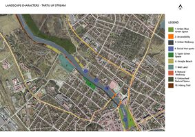
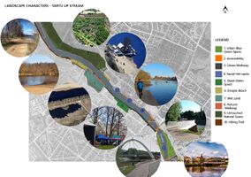
The most important motive for the city are people surround the river, as this space heavily used by people becouse of its values. They are created by the multiple pathways by the riveres, bridges, parks, platfmorms, river boulevards, man-made beaches, old Tartu Pool area which is now a renewed recreational space and hiking trails. River is quite simmetric
- Has the landscape been painted or otherwise depicted, when and whom? Which elements are essential?
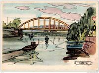
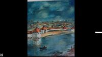
Landscape of Emajogi river has been painted mostly by Estonian arists. There has been a few motives that represents urban part of the river, nature surrounding it and mostly they comemorate Stone Bridge of Tartu which has been destroyed in 1941. The most famous representation of this bridge is created by Villem Ormisson named "Tartu vaade" which translates to "View of Tartu" painted in 1937. It is presenting how winter looked like in the city center and captures how light is moving through out buildings and the river which is characteristic for impressionism paintings.You can notice there how image of the citi has change from more of the urban approach with buildings on the side of the river and more of a man-made landscape. Tartu swimming pool is captured on Varmo Pirk's painting named 'Tartu Ujula' created in 1940r. There is also series of postcards painted by A. Kütt who captured the mosti iconic part of the city. They present everyday life in Tartu surrounded by the most iconic landmarks of the city. River and the bridges accompanied by fisherman and boats are a common motive on those proving the importance of the river space for the city.
- Which narratives exist? Who has written about this landscape or depicted it in some way?
Emajõgi is a irreversible part of a city and holds a great part in everyones heart. As the legends are saying Tartu was born out of the Mother River. She created the rythm of which city is living. Emajõgi is loved and respected but at the same time she often brings destruction by flooding the streets, which are cousing huge loses. Narrative about the river presents the life that is happening in its surrounding. Showing the river as a conector of the people and how much their life is connected to Emajogi - how it flows with all the actions floating around her. Idea like this is presented in a poem Tartu 'When It Sizzle' by Remo Gramigna.
</gallery>
Water and People
Accessibility and usability
- Where are your water areas accessible, and where not? How strong are spatial obstacles preventing access?
- Who is using the spaces and how?
Most of the Emajõgi River is accessible for people and it’s not accessible only in the parts of the natural protected area. Most of the access points are mainly pedestrian-only and very limited for the vehicle parts. On both banks of the river, the access points are the fishing places across the urbanized part of Tartu city with no vehicle access. On the western bank, the access points are the Roositiik beaches with no automobile access and some activities are available within water like ice bathing, swimming, etc. the western bank the Supilinna Tiik wetland which is a man-made wetland is not accessible for people there is a hiking trail along the river bank. On the eastern bank most of it accessible for a pedestrian on the Ranna Tee Street which it’s accessible for pedestrian for a walk and some activities such as musical concert and canoeing launching. The only place which is not accessible for water is the Püsietupaik Forest as it’s a natural protected area and there is a pine trees barrier the prevents any connection to the water feature. Most of the users of the Emajõgi River are local fishermen, families with kids for the beach area, young people, and especially university students.
Community Mapping
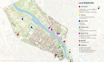
What is to be mapped here? Community mapping for the upstream part of the Emajõgi River has gone through a lot of history after World War II. The Soviet-era produced a Russian community in Estonia alongside the Estonian community which has a result of mixed culture. Tartu is considered a student city as there are two big universities (Tartu University and Estonian University of life sciences) which produced a huge student community in the city, not for the Estonians/Russians but for international students as well. The upstream of the Emajõgi River is well-known for the restaurant and cafes that are located at the city center which is near the western bank of the river. Which results in a local mixed community.
Social Groups
Families which most probably prefer places where they can enjoy their time with their kids in friendly places where they can do some activities.
Kids where they can do some scholar activities and some playgrounds.
Teenagers tend to go to places where it’s private and with some outdoor activities.
University students prefer to have spaces with activities within river banks.
Local stakeholder groups
University which is most of them are accessed to the river as University of Tartu Art Museum or it’s located on the water as University of Tartu Faculty of Economics and Business Administration.
Schools The schools use the green/blue structure for education and for activities such as field trips and they are located near the Emajõgi River
Sports Park which is a main outdoor recreational activity place for families and teenagers and even the university student
Youth club which is mainly for the canoeing club which is located on the eastern bank of the Emajõgi River
Market Tartu Market Hall is the main local market in Tartu which is located near to Riia bridge which is the main bridge in Tartu
- External stakeholder groups are not necessarily present in the environment you are observing, but they may have strong stakes and interests. These can be local authorities, politicians, associations, care services etc.
- For each group, you may identify their needs, objectives, power and capacities
- You may also identify gaps and power conflicts
- Please try to redepict these elements in an integrated way and in relation to your water landscape. What is the relationship between these groups? Are they close or distanced from each other? Who is more powerful? Which voices are hardly heard? Do they have any shared concerns?
Possible Futures
- You can summarize your findings with a SWOT diagram and a DPSI(R) Model
- Link back to the Sustainable Development Goals: Which goals are at risk?
- What is your worst case scenario for this landscape?
- What is your best case scenario for this landscape?
- Present your scenarios in the form of a collage or sketch
- Add text and visuals
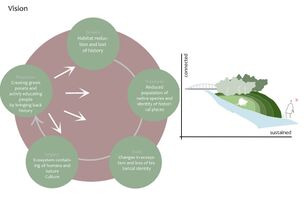
Problem that is common for our values which are biodiversity and haritage preservation is habitat reduction and loss of history. It can be coused by people losing connection with the river. In our Living Lab strong relation of flora, fauna and people is very well visable. Losing the habitat will couse reduction of native speciel and it will couse a lot of changes in urban ecostystem of Tartu. To preserve good relationship of history, nature and people we propose to create green pockets and recall activities of the past. It would bring back people to their roots, connect with nature more and appriciate this great working urban ecosystem which welcomed nature.
Scenario.png|Future scenarios File:your case_yourbestcase visual.jpg|explain your best case scenario briefly in the caption </gallery>
Collaborative Goal Setting
- Define strategic planning objectives based on the evaluation findings from your analysis
- Ideally, involve the community of your living labs into this process
- Link back to your original targets from section one and the Development Goals
- 150 words text contribution
The current state of our living lab nature wise is really good. We are not struggling with lack of activities, we have multiple biodiverse, green areas, clean water and we should preserve it. What makes our area special is the amount of history that was built around the river. Emajogi carries a huge part of the cultural heritage of Tartu. Our goal is to inform our target group about the importance of this kind of urban landscape which is well connected with the river environment.
Our assumptions agree with Goals of Susitainable Development which should be adopted by United Nations Member States. We focus on :
- sustaining clean water in our area by preventing further distructions
- creating sustainable city by preserving water-resilant landscape
- responsible consuption and production by creating low-impact activities for residence that could help them understand better importance of their landscape
- protect water life and life on land in urban enviroment by not invading natural landscape
- proposing partnerships of stakeholders to create stronger communities around the river
Spatial Strategy and Transect
- translate your strategic goals into a vision
- develop a spatial translation of your vision
- exemplify your vision in the form of a transect with concrete interventions
- add map(s) and visualizations
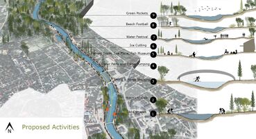
Looking back at history we can see that Tartu actually developed even though the landscape river ‘reversed’. Process of this deconstruction of the city was a positive thing for the relationship with the river. We can educate people about the importance of this relationship by showing how it changed in the last centuries. We can achieve it by proposing participating in the activities that were common in the past which involved the Emajogi river. To rediscover river landscape we propose to invite people on the journey of Past Tartu and introduce them to the history of the city. We can achieve it by following activities involving river which were common for their ancestors. We want to create an educational trail (2) of different kinds of activities. Some of them would be seasonal, some of them would need special infrastructure, but all of them will not invade the natural landscape of the river. Starting point of the trail would take place in the city. There would be some cameras (1) located all over the park and looking at the lense you are able to see tartu of the past, and relive this story. You are going to be able to see park covered by buildings and how people interacted with the river when the situation looked like this. As Tartu is located in the north and harsh winters are a reality we proposed winter activities which also have taken place in the past already. One of them would Ski Race and Horse Sledging (3) which would take place from historical location of Stone Bridge (Kaarsild) to Turusild which is a bridge located further north. Water Party and Barrel Jumping (4) would take place text to the Sport Center so they can supervise those activities, as equipment is needed for these. West side of the river is a popular fishing spot. TO connect people more to this heritage and educate about the importance of preserving river we propose to create workshops for kids, where they could fish their own fish and later eat them by preparing them at the fireplace. In the same place Fish Museum (5) could be located as well so you people can get educated about fauna and flora of the river. At Emajõe Lodjakoda Ice Cutting event could take place during winter (6). Beach nearby would be a starting point for a Water Festival (7) which would be continued after years of break. Beach Football (8) will take place at Tartu Beach and it would involve University students. We want to rediscovered already man made areas and preserve all the existing greenery (9).
From Theory of Change to Implementation
- For implementing your vision: Which partnerships are needed? Which governance model is required?
- Who needs to act and how? Draw and explain a change/process model/timeline
- Which resources are needed? On which assets can you build?
- add 150 words text and visuals
For implementing our vision it is necessary to create relationships with stakeholders like schools, universities, kindergartens to create strong communities around the river. Additionally to create recreation spots by the river to recall history it would be good to make connections with Sport Clubs so it can supervise water activities. As history is a strong part of our project, collaboration with Estonian National Museum could be beneficial, as they can provide knowledge and resources to present idea of showing Tartu of the past.
References
- https://www.maaamet.ee/et
- https://ajapaik.ee/photo/31644/tartu-emajogi/
- https://www.muis.ee/museaalview/2190254
- https://www.arcgis.com/apps/MapJournal/index.html?appid=7ae5364a9d6e4b70a7f181308c738776#:~:text=All%20of%20the%20drinking%20water,level%20tends%20to%20be%20high.
- https://www.atlasobscura.com/places/supilinn-the-soup-town
- https://avibase.bsc-eoc.org/checklist.jsp?region=EEta&list=howardmoore
Process Reflection
- Reflect in your intercultural and interdisciplinary team on the outcomes of your study
- Which limitations were you facing?
- What have you learnt from each other?
- What did you learn in the Living Labs?
- What would you do differently next time?
- You can also use diagrams/visuals
- 250 words text
Coming from different backgrounds it was interesting to see different ways of working on this project. We have learned how to share tasks and explain our ideas without actually seeing each other. Even though it takes longer time to discuss projects online we have always found a way to communicate and to came to similar conclusions. We also got much closer to water landscape we live near by today and make quicker observations and conclusions while spending time by the river. We understand what is working and not working in this landscape. As for pandemic we could not involve communities into the projects we were thinking of. Observing Living Lab was a very interesting experience, as we are not originally from Estonia. It was Surprising to see how well they manage the river in the city and how big is community showing interest in this subject. It's inspiring to see such a well-working environment. Additionally it was interesting to learn more about the history of our Living Lab and see how the relationship with the river changed and got preserved in some ways. We understand that our Living Lab is special because of the amount of layers that is preserving: from well maintained environment to very rich history background. Next time we would spend more time on consulting our ideas and discussing them more often, as with this we always got some new ideas to implement.
