WAVE Team 2 Freising 2021: Difference between revisions
Luke.miller (talk | contribs) |
Luke.miller (talk | contribs) |
||
| (37 intermediate revisions by 2 users not shown) | |||
| Line 11: | Line 11: | ||
{| align="right" width="400pt" style="background:Gainsboro; color:black" | {| align="right" width="400pt" style="background:Gainsboro; color:black" | ||
|- | |- | ||
| '''Area''' ||style="background:Lavender"| '' | | '''Area''' ||style="background:Lavender"| ''Bavaria'' | ||
|- | |- | ||
| '''Place''' || style="background:Lavender"|'' | | '''Place''' || style="background:Lavender"|''Freising (Dachau)'' | ||
|- | |- | ||
| '''Country''' || style="background:Lavender"|'' | | '''Country''' || style="background:Lavender"|''Germany'' | ||
|- | |- | ||
| '''Topics''' || style="background:Lavender"|'' | | '''Topics''' || style="background:Lavender"|''Peatland restoration'' | ||
|- | |- | ||
| '''Author(s)''' || style="background:Lavender"|'' | | '''Author(s)''' || style="background:Lavender"|''Marie-Luise Dexl and Luke Miller '' | ||
|- | |- | ||
| colspan="3" align="center" style="background:silver"| [[File: | | colspan="3" align="center" style="background:silver"| | ||
[[File:FRONTCOVER10.jpg|thumb]] | |||
|- | |- | ||
| ||style="background:Lavender"| | | ||style="background:Lavender"| | ||
| Line 40: | Line 41: | ||
= Water as a natural system = | = Water as a natural system = | ||
== Geomorphology, typologies and dynamics of water areas == | == Geomorphology, typologies and dynamics of water areas == | ||
Besides precipitation as an obvious source of water in the Isar river basin, the water system has numerous vital sources: Perhaps the most significant water source is the substantial ground water table which flows from the south to the north. | |||
In addition, the water system is supplied by Glacier & Snowmelt which melts after the winter snow fall periods and feeds the Isar River and other water bodies in the system, during the spring season. This dramatically increases the water table. | |||
Historically, the landscape around Freising, Munich and Dachau have traces of non-functioning canal systems. However there are still canal networks that are flowing and in use. Although some of these canals have degraded and no longer perform their initial functions of directing and channelling water, they have a high cultural and heritage value to the landscape. | |||
Furthermore, the region is scattered with lakes, dams and gravel excavation pits that have been converted into recreational swimming lakes (Pullinger Lake near Freising). Additionally, the Ismaninger Speichersee is situated close to the city of Dachau, while the south of the region is scattered with beautiful mountain lakes (Tegernsee, Walchensee and Starnbergersee). | |||
The landscape in this region supports an incredibly important biotope landscape: the Peatlands found in this region not only provide specific habitats to a wide variety of endemic flora and fauna, but also are regarded as a powerful alley in the fight against climate change for the function as a substantial storage of greenhouse gases. | |||
<gallery caption=" " widths="200px" heights="150px" perrow="5"> | <gallery caption=" " widths="200px" heights="150px" perrow="5"> | ||
| Line 69: | Line 74: | ||
== Blue and Green Infrastructure == | == Blue and Green Infrastructure == | ||
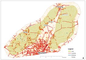
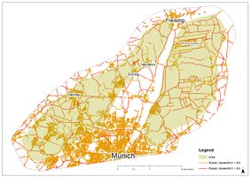
The map clearly shows a very fragmented green infrastructure, for example just small forest patches exist in the area. Special forest types can evolve on peatland as well, like 'lichter Moorwald', mostly formed by birches. A mayor element found is agricultural used land, which evokes a conflict with peatland soils (draining of peatland etc.). The blue infrastructure is good connected, with the Isar river and the 'Ismaninger Speichersee' as main elements. It is very likely, that green and blue infrastructure will change and espacially green infrastructure vanish in the future, because of the settlement pressure from the surrounding regions. | |||
<gallery caption=" " widths="200px" heights="150px" perrow="5"> | <gallery caption=" " widths="200px" heights="150px" perrow="5"> | ||
File: | File:GreenAndBluePeatlandsFreising.jpg|thumb|Here, green (Forests, Natural Areas, Agricultural used Areas) and blue (Waterbodies and -ways) infrastructure is shown in the Peatlands, as well as the peatland soils | ||
File: | File:GreenAndBluePeatlandsFreisingFragmentation.jpg|thumb|This map shows the fragmentation of the green and blue infrastructure by roads, that are used by car. | ||
</gallery> | </gallery> | ||
| Line 100: | Line 102: | ||
== Cultural and spatial typologies of water areas == | == Cultural and spatial typologies of water areas == | ||
The area is mostly influenced by its agricultural use (draining of peatland area), as well as settlements and the munich airport, as seen in the map. The initial peatland area was reduced and fragmented by these land-use change processes,this is still going on. It is possible to say, the the use-patterns which evolved are mostly agriculture and settling. | |||
The | The remaining part is important for waterextraction and other ecosystem services, as explained before, so the use-patterns can be called extracting of goods for human health. Here, other evolved use-patterns, in connection to the identity of the landscape is the recreation and experiencing the landscape. | ||
<gallery caption=" " widths="200px" heights="150px" perrow="5"> | <gallery caption=" " widths="200px" heights="150px" perrow="5"> | ||
File: | File:HistoricalPeatlandFreising.jpg|thumb|This map shows the extensions of the historical peatland before the construction of the munich airport. | ||
File: | File:ActualPeatlandFreising.jpg|thumb|This map shows the extensions of the recent peatlandsoil. | ||
File: | File:PeatlandOLDNEWFreising.jpg|thumb|This map shows the overlay of old and new peatland area with the outlines of settlement and the airport area. | ||
</gallery> | </gallery> | ||
| Line 121: | Line 122: | ||
== Visual appearance and landscape narrative == | == Visual appearance and landscape narrative == | ||
The peatlands and especially the ''Dachauer Moos'' were and are important recreation areas near munich. Here the people can flee from the overall urban cities into a more or less still waste and natural landscape. This is very important for most of the people living in big cities. | |||
This use for recreation was especially aprreciated by famous painters in the past. They came there to paint the beautiful and idyllic landscape. Often its wildness is stressed, so one essential element, still today, are the natural areas. But nowadays, historical elements shape the landscape as well, like the 'Schleißheimer canalsystem' or the 'Neues Schloss Schleißheim'. Agricultural areas are also an important elemnt that shaped and still shapes the landscape. The rural sides were also painted by painters and are today visited by the normal population. But the ways of agricultural use changed and more areas are intensified, changing the special character of the landscape and turning it into a homogenic and generic landscape, which is often found in germany. | |||
It is possible to say, that the peatlands amazed people back then as well as today. This gives them an important role for the identification of the people with their landscape and therefore with their home. | |||
<gallery caption=" " widths="200px" heights="150px" perrow="5"> | <gallery caption=" " widths="200px" heights="150px" perrow="5"> | ||
File: | File:PersonInThePeatlandsFreising.jpeg|thumb|This pictures shows the connection of the participants of the wave project to the peatlands | ||
File: | File:Dachauer Moos Philipp Röth.jpg|thumb|Especially the ''Dachauer Moos'' was a famous place for painters and is topic of a lot paintings' | ||
File: | File:Fritz von Uhde - Im Herbst (Die Hirtin im Dachauer Moos).jpg|thumb|This painting from Fritz von Uhde shows a person (a shepherdess) which had a strong connection to the peatlands | ||
</gallery> | </gallery> | ||
= Water and People = | = Water and People = | ||
| Line 146: | Line 144: | ||
</gallery> | </gallery> | ||
== Community Mapping == | == Community Mapping == | ||
'''Main stakeholder''' have an direct interest in the peatlands around Dachau and Freising. They are connected and partly dependent on this area, e.g. the farmers whose fields are stated there. In this group, 4 groups could be identified: '''The community''' has a big interest in the peatlands with a connection to all evaluation goals. Their needs are basic, like goods from the peatlands as well as recreation and identity feeling. The power of the community is not high, because they are not organized in any way, nevertheless the acceptance of the community is essentiell for projects to be successful; Conflicts could pop-up without acceptance. The objective of this group is to have all of their needs to be satisfied, with a higher acceptance of the project, unsatisfied needs will be less problematic. | |||
'''The Dachauer Moos Verein''' is a group that renaturates, manages and maintance already renaturated areas in the Peatlands. They have a wide knowledge about the area, how to renaturate and monitore areas, as well as a level of acceptance by the people. Their power is limited to their own areas. An objective of this group is to extend the areas of the group to help nature and renaturate the peatlands. To do so, they need funding and partly more cooperation. They are possibly interested in all values. | |||
'''The Institute for ecology and landscape of the university of applied science weihenstephan-triesdorf''' has some scientific projects stated in peatlands. They could be interested in having access to new study areas and have a lot of knowledge in establish sustainable agriculture which is better for the climate than traditional landuse. he power of this group is relatively low and the interest is just correlating with the carbon storage value, nevertheless the interest in this value is overproportional high, also they could help with lowering the conflict potential with farmers with showing them possibillities to save the peatlands and use them in a economical way. A possible conflict could be, that the identity and biodiversity can not be enhanced as compared to renaturated areas. | |||
'''Farmers''' in the area have a lot of power, because of the ownership of the areas. The farmland is the base for their existance, so they need to have enough income from their work. This group has a great potential but also a high risk of conflicts, which means the acceptance for the project is one of the most important ones. | |||
'''Interested stakeholders''' have an interest in a landuse change in the peatlands, but not directly, like schools who could use this area for educational use. | |||
The group of '''other stakeholder''' shows groups which are connected to the peatlands but not interested in a landuse change, e.g. church groups which care for nature. | |||
<gallery caption=" " widths="500px" heights="200px" perrow="5"> | <gallery caption=" " widths="500px" heights="200px" perrow="5"> | ||
File: | File:StakeholderDiaFreisingPeats.JPG|thumb|This Diagramm shows some Stakeholders. Main stakeholders are groups that can have the main interest and other stakeholders the least, interested stakeholders are interested but not as much asa the main stakeholders. | ||
File: | File:MainStakeholderinThePeatlands.JPG|thumb|This Diagramm shows in which values which main stakeholder could have an interest. There are also possible conflicts with stakeholders shown. | ||
File: | File:Coflict MainPeoplePeatland.JPG|thumb|This graphic shows the potential of conflicts and the level of power towards a project and conflicts or alliances between the main stakeholders. | ||
</gallery> | </gallery> | ||
| Line 179: | Line 176: | ||
= Collaborative Goal Setting = | = Collaborative Goal Setting = | ||
'''(1)IDENTITY VALUE''' | |||
As there is a strong historical associate with this landscape with the communities that live in and around our focus area: the need of acknowledging this historical association that is slowly being eroded away as the peatlands are subjected to further fragmentation and the eventual destruction of their existence, it is paramount that initiatives are made to reconnect the community with this landscape in a way where the community can have '''access''' to the rich cultural ecosystem services that this landscape provides. | |||
Therefore a primary development goal of the Identity Value is to create an opportunity for the surrounding communities to reconnect with peatlands that are not only focused on the provisioning, supporting and regulating services that they provide. | |||
'''(2)BIODIVERSITY VALUE''' | |||
As this landscape is an important and vital habitat for many flora and fauna species, it is important to acknowledge this and further develop an '''ecological network''' where species can be supported and allowed to flourish. | |||
'''(3)CARBON STORAGE VALUE''' | |||
This goal and value is essentially connected to the crux of the matter; that '''protecting''' peatlands is in the best interests of all stakeholder groups - therefore a solution must be reached. By bringing awareness to the communities that surround this landscape, through providing direct access into the peatlands for the wider community (eg. the Identity Value and reestablishing this strong historical association with Peatlands), a new ''' collective vision''' can be reached where all stakeholders can still benefit from the landscape, including the peatlands themself. | |||
Henceforth, developing '''multifunctional spatial strategies''' is the most effective and efficient solution in this regard; green ecological networks, naturalized areas primarily zoned for nature to thrive, agricultural activities like paludiculture and potentials for ecological compensation techniques can be envisioned. | |||
<gallery caption=" " widths="200px" heights="150px" perrow="5"> | |||
File:Sustainability goals.jpg|thumb|The Sustainability Development Goals that are relevant to our project site: '''Goals 12, 13, 14,15''' | |||
File:Development goals and values.jpg|thumb|The values and development goals for our project site are centred around these 3 core values of the Peatland-scape | |||
</gallery> | |||
= Spatial Strategy and Transect = | = Spatial Strategy and Transect = | ||
<gallery caption=" " widths="500px" heights="200px" perrow="1"> | <gallery caption=" " widths="500px" heights="200px" perrow="1"> | ||
File: | File:Landuse map vision.jpg|thumb|This map proposes a land-use vision through the implementation of transitional zones between these two realms, we look at how we can bridge the manmade with the natural through an ecological network of forested areas that can serve both as a green corridor network and as a green buffer while addressing the biodiversity value . and through protecting peatland land-use we propose a change of conventional agricultural practices to peatland supporting agricultural practices while also providing naturalised peatland zones in the dark pink/red colour. And finally the transitional zones themselves provide a space where people can interact with the peatlands, further addressing the identity value. | ||
File: | File:IMPLEMENTATION MAPS.jpg|thumb|And to understand this map further we look at implementation maps of the existing situation in this project area to a collaborative vision of community to partnerships with farmers, communities, scientists, and government to ultimately achieve the protection of this vital amphibious landscape – the peatlands. First we propose that the existing fragmented forests are reconnected in an ecological network through a community based planting project Then the analysis of agricultural practices currently being performed in this region and where these activities intersect with peatlands, the initiative to transform these harmful land-use activities to peatland supporting projects like paludiculture. And finally the vision of looking at the peatland and spatially articulating where peatlands can be re-naturalised and coexist and be supported by the surrounding manmade landscape | ||
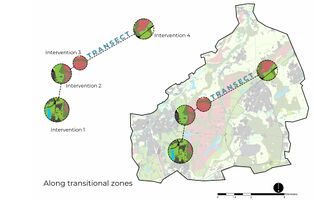
File: | File:Transect map.jpg|thumb|To understand how such broad visions could be implemented on a design level, we utilised the transect technique; interventions along the proposed transitional zones of the urban fabric to the remaining peatland areas | ||
File: | File:Transect section 1.jpg|thumb|this diagrammatic section shows the urban situation in this area and how the manmade could be used to potentially support peatlands. The transitional zones become a space for the opportunity of multicoding on these peri-urban areas with multifunctional services and activities. For example, through a rainwater collection network of rain gardens and directing water to these transitional zones, water can be essentially filtered and directed back into the ground water table and into the peatlands | ||
File:Visualizations.jpg|thumb|to elaborate on this concept of multi-coding within the transitional zones we developed these section visualizations. In the left graphic 1 and 2 multi-coding interventions can be applied; the wetlands can be used to help filter urban storm water back into the peatlands (rewetting) while, secondly acting as a (green corridor) mobility network for people to experience the landscape through having timber viewing decks for people to access this space and look into the beautiful and scenic peatland views. In the right graphic 3 and 4 multi-coding interventions are applied; with the implementation of Paludiculture based community gardens, the community can be educated about the importance of peatlands and how they function – further establishing the historical connection with them. And lastly, the forested green buffers of tree species that have historically existed in peatlands, can be planted along these edges, to further protect peatlands from urban sprawl. Therefore these interventions could be strategically implemented within the landscape to rather support humans and peatlands rather than the destruction of peatlands | |||
</gallery> | </gallery> | ||
= From Theory of Change to Implementation = | = From Theory of Change to Implementation = | ||
The '''further process''' is explained in the following diagramm. In the ''preparation process'', the main stakeholders should be involved and gained as partners, suitable areas should be found and tested for spacial (right place?) and environmental (right environment?) as well as economical (affordable?) suitability. Then these areas should be accessed by getting supervision of the areas.Afterwards, the ''measure process''starts, where exact planning and execution are taking place. At the beginning of each measure baseline data will be taken, for comparing the beginning state and the end state of the area. The last process, the ''fulfilled vision'', management should take place, where areas are monitored and maintained to be permanent in the future. Also, a sucess control and evaluation will take place at the finalization of each measure. | |||
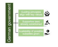
The '''governmence model''' which is required is already established in germany. A lot of guiding principles of the government in the nature conservation, identity enhance and carbon storage are supportative for our vision. Existant laws e.g. for protecting nature are already established and it is possible to apply for subsidies to fund the project. | |||
'''Needed ressources''' are suitable and available areas for the measures, know-how to plan in detail and complete the vision, as well as ressources to manage the restored areas to grant a permanence and quality of the fullfilled vision. Another very important ressource is money, which could be raised by funds or the government. | |||
In the implementing process, we decided to introduce the main stakeholders as partners. They could have the highest interest in our vision for the peatland areas. It is possible, they will give advise, help in the process/management or help with the funding. Acceptance of the community very important and could be enhanced by forming a partnership. | |||
'''Community''': The community could help with the planting of trees and the funding of the whole project. Local people have often good connection with farmers and know suitable and available areas. | |||
'''Dachauer Moos Verein''': This club could be interested in expanding its areas and could fill the gap of technical know-how, management ressources and partly the funding. | |||
'''Institute for ecology and landscape''': This institute of the University of applied science Weihenstephan-Triesdorf is working with the implementation of agriculture that is sustainable and saves the carbon storage in the peat. The scientists can help with technical know-how and could also expand their scientific work to this area. | |||
'''Farmers''': The farmers are extential partners for the project. Most of them are the owners of the area and are should involved in the planning, the construction and the management process. The acceptance is essentiell as well. | |||
<gallery caption=" " widths="500px" heights="200px" perrow="1"> | <gallery caption=" " widths="500px" heights="200px" perrow="1"> | ||
File: | File:GovernmentGermanyPeatlandsFreieing.JPG|thumb|This graphic shows that german governmance gives all the governmental elements needed in the project. | ||
File: | File:Process with TIME-Peat.JPG|thumb|This Diagramm shows the process parts, what is happening in which step and at which pint of time. | ||
</gallery> | </gallery> | ||
== References == | == References == | ||
* | * Bayerisches Landesamt für Umwelt. LfU. Available online at www.lfu.bayern.de. | ||
* Botanische Staatssammlung München: Botanischer Informationsknoten Bayern. Steckbriefe zu den Gefäßpflanzen Bayerns. Available online at http://daten.bayernflora.de/de/info_pflanzen.php?taxnr=3101. | |||
* Verein Dachauer Moos e.V. (2016): Vegetation. Available online at https://www.verein-dachauer-moos.de/landschaft/vegetation.html. | |||
* Zech, Wolfgang; Schad, Peter; Hintermaier-Erhard, Gerd (2014): Böden der Welt. Ein Bildatlas. 2. Auflage. Berlin, Heidelberg: Springer Spektrum (SpringerLink Bücher) | |||
Data used for maps and spatial analysis are given with the pictures | |||
= Process Reflection = | = Process Reflection = | ||
Latest revision as of 10:00, 7 June 2021
>>>back to working groups overview
| Area | Bavaria | |
| Place | Freising (Dachau) | |
| Country | Germany | |
| Topics | Peatland restoration | |
| Author(s) | Marie-Luise Dexl and Luke Miller | |
Rationale
Peatlands in general are an important living space for humans and nature. Also the peatlands near Freising have a high importance for the population in a cultural and an ecological sense, which means it is delivering important ecosystem services. A possible challenge, this landscape is facing is the land-use change which happened in the past and is still happening.
Location and scope
You can edit this map with the map editor
Water as a natural system
Geomorphology, typologies and dynamics of water areas
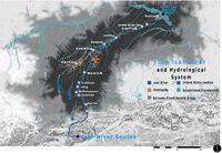
Besides precipitation as an obvious source of water in the Isar river basin, the water system has numerous vital sources: Perhaps the most significant water source is the substantial ground water table which flows from the south to the north.
In addition, the water system is supplied by Glacier & Snowmelt which melts after the winter snow fall periods and feeds the Isar River and other water bodies in the system, during the spring season. This dramatically increases the water table.
Historically, the landscape around Freising, Munich and Dachau have traces of non-functioning canal systems. However there are still canal networks that are flowing and in use. Although some of these canals have degraded and no longer perform their initial functions of directing and channelling water, they have a high cultural and heritage value to the landscape.
Furthermore, the region is scattered with lakes, dams and gravel excavation pits that have been converted into recreational swimming lakes (Pullinger Lake near Freising). Additionally, the Ismaninger Speichersee is situated close to the city of Dachau, while the south of the region is scattered with beautiful mountain lakes (Tegernsee, Walchensee and Starnbergersee).
The landscape in this region supports an incredibly important biotope landscape: the Peatlands found in this region not only provide specific habitats to a wide variety of endemic flora and fauna, but also are regarded as a powerful alley in the fight against climate change for the function as a substantial storage of greenhouse gases.
Water as a living space
In former times, the peatlands have been a habitat for special plant and animal species, like birds, insects, or amphibians. Nowadays it is cut by settlements, roads, and the Munich Airport, some parts are used for agriculture. Just patches of natural habitats have survived, like the ‘Streu- und Feuchtwiesen’ or the ‘lichten Moorwälder’ in the areas of the Verein Dachauer Moos e.V. Here, highly protected plant species, like Iris sibirica (lily) or Scorpidium (moss) can be found, which makes these habitats really special. Even in ditches and streams special Flora and Fauna can be found. Some of these areas part of the NATURA2000 Programme and therefore protected by European law. Furthermore, a lot of lakes and rivers can be found here, some with special flora and fauna as well.
The water quality of this area is depending on the quality of the groundwater. Some areas are drinking water areas with sufficient water quality to use it for human consumption. In other parts, intensive agricultural or urban land-use is lowering the water quality.
Blue and Green Infrastructure
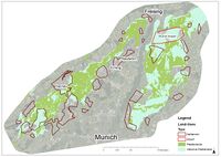
The map clearly shows a very fragmented green infrastructure, for example just small forest patches exist in the area. Special forest types can evolve on peatland as well, like 'lichter Moorwald', mostly formed by birches. A mayor element found is agricultural used land, which evokes a conflict with peatland soils (draining of peatland etc.). The blue infrastructure is good connected, with the Isar river and the 'Ismaninger Speichersee' as main elements. It is very likely, that green and blue infrastructure will change and espacially green infrastructure vanish in the future, because of the settlement pressure from the surrounding regions.
Water as a cultural space
Land use and water
In an early stage, especially the Dachauer Moos, was a waste Landscape, home of murderers and thieves, who got no where else to go.
Later, more and more people came to the peatlands to cultivate them and use it for peat extraction (e.g. used as heat material) and agriculture. Therefore, the peatland was drained, which also changed the soil characteristics, leading to Greenhouse gas emissions from the soil. In this time more and more painters came to the peatlands, to paint the beautiful landscape. Meanwhile, the urbanization of the landscape was intensified.
Today, this landscape is highly urbanized and in agricultural use with small patches of natural areas.
It is very likely that the human use of the landscape is intensified, because of driving forces like the need of living space or agricultural land for humans. Drivers in the opposite direction are the identification with the peatlands as a ‘Home landscape’ and need of the population for recreation.
Draining the landsdcape, and therefore intensifiing the land-use has an impact on the storage of carbon in the peatland soil. When draining peat, the carbon is released in a form of greenhouse gas emissions and is distributing significantly to climate change. The process is explained here in a simple way: While the upbuilding of the peatlands, plants use CO2 for photosynthesis. In this process, the plants store the CO2 as organic matter and die. Due to the high water table, this organic material is decomposed slower than its build up and can be stored. If the proportion of organic substance exceeds 30%, it is called peat. If this peat is drained, the organic matter is decomposed faster than it is build up and the carbon is released as greenhouse gases, e.g., CO2.
Cultural and spatial typologies of water areas
The area is mostly influenced by its agricultural use (draining of peatland area), as well as settlements and the munich airport, as seen in the map. The initial peatland area was reduced and fragmented by these land-use change processes,this is still going on. It is possible to say, the the use-patterns which evolved are mostly agriculture and settling. The remaining part is important for waterextraction and other ecosystem services, as explained before, so the use-patterns can be called extracting of goods for human health. Here, other evolved use-patterns, in connection to the identity of the landscape is the recreation and experiencing the landscape.
Sacred spaces and heritage
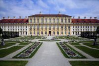
Most places, which are important in a cultural way have been build with a religious purpose, for example Churches or chapels. The importance arised in the past, where religion was very important for the people. Other important places like the water tower or certain castles are important as a landmark or their history, which is connected with the there living people. Especially important is the Canalsystem of the Neues Schloss Schleißheim as well as the castle itself. Both are important landmarks with a lot of history. Aditionally, both monuments are very famous and protected after national law.
Visual appearance and landscape narrative
The peatlands and especially the Dachauer Moos were and are important recreation areas near munich. Here the people can flee from the overall urban cities into a more or less still waste and natural landscape. This is very important for most of the people living in big cities. This use for recreation was especially aprreciated by famous painters in the past. They came there to paint the beautiful and idyllic landscape. Often its wildness is stressed, so one essential element, still today, are the natural areas. But nowadays, historical elements shape the landscape as well, like the 'Schleißheimer canalsystem' or the 'Neues Schloss Schleißheim'. Agricultural areas are also an important elemnt that shaped and still shapes the landscape. The rural sides were also painted by painters and are today visited by the normal population. But the ways of agricultural use changed and more areas are intensified, changing the special character of the landscape and turning it into a homogenic and generic landscape, which is often found in germany. It is possible to say, that the peatlands amazed people back then as well as today. This gives them an important role for the identification of the people with their landscape and therefore with their home.
Water and People
Accessibility and usability
It is possible to enter the landscape everywhere, it is accessible by roads and paths for cars, bikes and by foot. Most of the areas are used by farmers to produce agricultural products, some are also keeping animals like cows or horses. The more natural areas are used by the surrounding population for recreation by taking walks, walking your dog or swimming in lakes. Some people are protecting and renaturing areas, they use it as a identification with their living spaces. There are different uses of the peatland around freising. The natural areas have a recreational potential for walking or relaxing, taking a break from the urban spaces for the surounding population. Cycling and riding tracks as well as the water areas can be used for sportive activities and the monuments show a potential for a touristic even educational use. These monuments can also be used to enhance the identical connection of landscape and people, like the whole peatland area.
Community Mapping
Main stakeholder have an direct interest in the peatlands around Dachau and Freising. They are connected and partly dependent on this area, e.g. the farmers whose fields are stated there. In this group, 4 groups could be identified: The community has a big interest in the peatlands with a connection to all evaluation goals. Their needs are basic, like goods from the peatlands as well as recreation and identity feeling. The power of the community is not high, because they are not organized in any way, nevertheless the acceptance of the community is essentiell for projects to be successful; Conflicts could pop-up without acceptance. The objective of this group is to have all of their needs to be satisfied, with a higher acceptance of the project, unsatisfied needs will be less problematic. The Dachauer Moos Verein is a group that renaturates, manages and maintance already renaturated areas in the Peatlands. They have a wide knowledge about the area, how to renaturate and monitore areas, as well as a level of acceptance by the people. Their power is limited to their own areas. An objective of this group is to extend the areas of the group to help nature and renaturate the peatlands. To do so, they need funding and partly more cooperation. They are possibly interested in all values. The Institute for ecology and landscape of the university of applied science weihenstephan-triesdorf has some scientific projects stated in peatlands. They could be interested in having access to new study areas and have a lot of knowledge in establish sustainable agriculture which is better for the climate than traditional landuse. he power of this group is relatively low and the interest is just correlating with the carbon storage value, nevertheless the interest in this value is overproportional high, also they could help with lowering the conflict potential with farmers with showing them possibillities to save the peatlands and use them in a economical way. A possible conflict could be, that the identity and biodiversity can not be enhanced as compared to renaturated areas. Farmers in the area have a lot of power, because of the ownership of the areas. The farmland is the base for their existance, so they need to have enough income from their work. This group has a great potential but also a high risk of conflicts, which means the acceptance for the project is one of the most important ones. Interested stakeholders have an interest in a landuse change in the peatlands, but not directly, like schools who could use this area for educational use. The group of other stakeholder shows groups which are connected to the peatlands but not interested in a landuse change, e.g. church groups which care for nature.
Possible Futures
In our systems analysis of the Peatlandscape we have identified 4 main Sustainability goals that are at risk: (12)Responsible Consumption and Production - as agriculture is in sharp contrast with these peatlands, it is paramount that sustainable agricultural methods be used in harmony with peatlands (13)As Peatlands are indispensable against the fight against climate change, as an essential carbon store habitat and they have been drained in many parts of our focus area (14)Peatlands are comprised of important habitats for aquatic species that are jeopardized when peatlands are destroyed (15)A peatland is a landscape that encompasses the realms of both water and landscapes and is there an important landscape to protect
The worst-case scenario: Neglected and Urbanized describes a landscape that has been entirely exploited where peatlands no longer exist. The concrete cubes represent the urban landscape that continues unabated, further fragmenting and utilizing the landuse. The maize crops represent conventional agricultural practices where peatlands are drained for the use of conventional agriculture.
The best-case scenario Protected and Naturalised is a landscape where humans farm in harmony with peatlands, where science is used to continue the careful monitoring of peatlands and the ultimate protection of their existence - by maintaining the water table within the landscape
Collaborative Goal Setting
(1)IDENTITY VALUE As there is a strong historical associate with this landscape with the communities that live in and around our focus area: the need of acknowledging this historical association that is slowly being eroded away as the peatlands are subjected to further fragmentation and the eventual destruction of their existence, it is paramount that initiatives are made to reconnect the community with this landscape in a way where the community can have access to the rich cultural ecosystem services that this landscape provides.
Therefore a primary development goal of the Identity Value is to create an opportunity for the surrounding communities to reconnect with peatlands that are not only focused on the provisioning, supporting and regulating services that they provide.
(2)BIODIVERSITY VALUE As this landscape is an important and vital habitat for many flora and fauna species, it is important to acknowledge this and further develop an ecological network where species can be supported and allowed to flourish.
(3)CARBON STORAGE VALUE This goal and value is essentially connected to the crux of the matter; that protecting peatlands is in the best interests of all stakeholder groups - therefore a solution must be reached. By bringing awareness to the communities that surround this landscape, through providing direct access into the peatlands for the wider community (eg. the Identity Value and reestablishing this strong historical association with Peatlands), a new collective vision can be reached where all stakeholders can still benefit from the landscape, including the peatlands themself.
Henceforth, developing multifunctional spatial strategies is the most effective and efficient solution in this regard; green ecological networks, naturalized areas primarily zoned for nature to thrive, agricultural activities like paludiculture and potentials for ecological compensation techniques can be envisioned.
Spatial Strategy and Transect
This map proposes a land-use vision through the implementation of transitional zones between these two realms, we look at how we can bridge the manmade with the natural through an ecological network of forested areas that can serve both as a green corridor network and as a green buffer while addressing the biodiversity value . and through protecting peatland land-use we propose a change of conventional agricultural practices to peatland supporting agricultural practices while also providing naturalised peatland zones in the dark pink/red colour. And finally the transitional zones themselves provide a space where people can interact with the peatlands, further addressing the identity value.
And to understand this map further we look at implementation maps of the existing situation in this project area to a collaborative vision of community to partnerships with farmers, communities, scientists, and government to ultimately achieve the protection of this vital amphibious landscape – the peatlands. First we propose that the existing fragmented forests are reconnected in an ecological network through a community based planting project Then the analysis of agricultural practices currently being performed in this region and where these activities intersect with peatlands, the initiative to transform these harmful land-use activities to peatland supporting projects like paludiculture. And finally the vision of looking at the peatland and spatially articulating where peatlands can be re-naturalised and coexist and be supported by the surrounding manmade landscape
this diagrammatic section shows the urban situation in this area and how the manmade could be used to potentially support peatlands. The transitional zones become a space for the opportunity of multicoding on these peri-urban areas with multifunctional services and activities. For example, through a rainwater collection network of rain gardens and directing water to these transitional zones, water can be essentially filtered and directed back into the ground water table and into the peatlands
to elaborate on this concept of multi-coding within the transitional zones we developed these section visualizations. In the left graphic 1 and 2 multi-coding interventions can be applied; the wetlands can be used to help filter urban storm water back into the peatlands (rewetting) while, secondly acting as a (green corridor) mobility network for people to experience the landscape through having timber viewing decks for people to access this space and look into the beautiful and scenic peatland views. In the right graphic 3 and 4 multi-coding interventions are applied; with the implementation of Paludiculture based community gardens, the community can be educated about the importance of peatlands and how they function – further establishing the historical connection with them. And lastly, the forested green buffers of tree species that have historically existed in peatlands, can be planted along these edges, to further protect peatlands from urban sprawl. Therefore these interventions could be strategically implemented within the landscape to rather support humans and peatlands rather than the destruction of peatlands
From Theory of Change to Implementation
The further process is explained in the following diagramm. In the preparation process, the main stakeholders should be involved and gained as partners, suitable areas should be found and tested for spacial (right place?) and environmental (right environment?) as well as economical (affordable?) suitability. Then these areas should be accessed by getting supervision of the areas.Afterwards, the measure processstarts, where exact planning and execution are taking place. At the beginning of each measure baseline data will be taken, for comparing the beginning state and the end state of the area. The last process, the fulfilled vision, management should take place, where areas are monitored and maintained to be permanent in the future. Also, a sucess control and evaluation will take place at the finalization of each measure. The governmence model which is required is already established in germany. A lot of guiding principles of the government in the nature conservation, identity enhance and carbon storage are supportative for our vision. Existant laws e.g. for protecting nature are already established and it is possible to apply for subsidies to fund the project. Needed ressources are suitable and available areas for the measures, know-how to plan in detail and complete the vision, as well as ressources to manage the restored areas to grant a permanence and quality of the fullfilled vision. Another very important ressource is money, which could be raised by funds or the government. In the implementing process, we decided to introduce the main stakeholders as partners. They could have the highest interest in our vision for the peatland areas. It is possible, they will give advise, help in the process/management or help with the funding. Acceptance of the community very important and could be enhanced by forming a partnership. Community: The community could help with the planting of trees and the funding of the whole project. Local people have often good connection with farmers and know suitable and available areas. Dachauer Moos Verein: This club could be interested in expanding its areas and could fill the gap of technical know-how, management ressources and partly the funding. Institute for ecology and landscape: This institute of the University of applied science Weihenstephan-Triesdorf is working with the implementation of agriculture that is sustainable and saves the carbon storage in the peat. The scientists can help with technical know-how and could also expand their scientific work to this area. Farmers: The farmers are extential partners for the project. Most of them are the owners of the area and are should involved in the planning, the construction and the management process. The acceptance is essentiell as well.
References
- Bayerisches Landesamt für Umwelt. LfU. Available online at www.lfu.bayern.de.
- Botanische Staatssammlung München: Botanischer Informationsknoten Bayern. Steckbriefe zu den Gefäßpflanzen Bayerns. Available online at http://daten.bayernflora.de/de/info_pflanzen.php?taxnr=3101.
- Verein Dachauer Moos e.V. (2016): Vegetation. Available online at https://www.verein-dachauer-moos.de/landschaft/vegetation.html.
- Zech, Wolfgang; Schad, Peter; Hintermaier-Erhard, Gerd (2014): Böden der Welt. Ein Bildatlas. 2. Auflage. Berlin, Heidelberg: Springer Spektrum (SpringerLink Bücher)
Data used for maps and spatial analysis are given with the pictures
Process Reflection
- Reflect in your intercultural and interdisciplinary team on the outcomes of your study
- Which limitations were you facing?
- What have you learnt from each other?
- What did you learn in the Living Labs?
- What would you do differently next time?
- You can also use diagrams/visuals
- 250 words text
