WAVE Team 2 Nuertingen 2021: Difference between revisions
| (120 intermediate revisions by 6 users not shown) | |||
| Line 13: | Line 13: | ||
| '''Area''' ||style="background:Lavender"| Baden-Württemberg | | '''Area''' ||style="background:Lavender"| Baden-Württemberg | ||
|- | |- | ||
| '''Place''' || style="background:Lavender"| | | '''Place''' || style="background:Lavender"|Nürtingen | ||
|- | |- | ||
| '''Country''' || style="background:Lavender"|Germany | | '''Country''' || style="background:Lavender"|Germany | ||
| Line 19: | Line 19: | ||
| '''Topics''' || style="background:Lavender"|WAVE Project | | '''Topics''' || style="background:Lavender"|WAVE Project | ||
|- | |- | ||
| '''Author(s)''' || style="background:Lavender"| | | '''Author(s)''' || style="background:Lavender"|Yara Karazi, Sara dos Santos Figueiredo, Mahasta Mahfouzi, Rabija Hadzimehmedovic, Israt Jahan Nishat | ||
|- | |- | ||
| colspan="3" align="center" style="background:silver"| [[File:Steinach nuertingen group2.jpg|400px]] | | colspan="3" align="center" style="background:silver"| [[File:Steinach nuertingen group2.jpg|400px]] | ||
| Line 29: | Line 29: | ||
= Rationale = | = Rationale = | ||
* | |||
* | *Nürtingen is a small but important service and economic center in the metropolitan region of Stuttgart, based in Baden Wurttemberg province. The city has developed over the course of the years by the Neckar river, the Rhine tributary, which brings Neckar to an important role of the human society and needs. | ||
*The aspects that were and still are challenging consider the naturality of the river, the floodplains by the settlements, and taking care of the biodiversity. The main goal is to use existing Blue-green infrastructures and restore the local waterbodies like cricks, wetlands, the river Neckar, and its tributaries to reduce flooding risks to adjacent neighborhoods while simultaneously supporting urban agricultural production and wildlife, in addition, to provide recreational benefits to the surrounding community. | |||
= Location and scope = | = Location and scope = | ||
''You can edit this map with the [[Special:MapEditor|map editor]]'' | ''You can edit this map with the [[Special:MapEditor|map editor]]'' | ||
{{#display_map: | {{#display_map: 48.625611346021174,9.334788268822534~Nürtingen Steinach | ||
}} | }} | ||
| Line 41: | Line 42: | ||
== Geomorphology, typologies and dynamics of water areas == | == Geomorphology, typologies and dynamics of water areas == | ||
*''Describe the water areas of your area in the contxt of the wider water system'' | *''Describe the water areas of your area in the contxt of the wider water system'' | ||
The Neckar River is the tenth largest river in Germany with a length of 362 km. The river begins in the Black Forest the southwest of Baden-Württemberg at an elevation of 706 meters above sea level and flows into the Rhine river at Mannheim, at 95 m above sea level, after passing through the cities of Rottweil, Rottenburg am Neckar, Kilchberg, Tübingen, Wernau, Nürtingen, Plochingen, Esslingen, Stuttgart, Ludwigsburg, Marbach, Heilbronn, and Heidelberg. | |||
*''How does water appear in the landscape of your living lab? What types of water areas are common? | *''How does water appear in the landscape of your living lab? What types of water areas are common? | ||
Water takes different forms depending on a variety of circumstances, such as typology and the geography of each place. The Neckar River is the most important river in the city of Nürtingen, flowing from almost north to northwest of the city. There are also several small rivers generated by the Neckar River in this city, including the Tiefenbnach Steinach, Aich, Marbach, and Aischenbach. This river, its tributaries, and lakes (standing water) are the common water areas in this living lab. | |||
*''Please identify the water bodies' catchment areas, tributaries and floodplains | *''Please identify the water bodies' catchment areas, tributaries and floodplains | ||
The Neckar river's catchment area covers around 13,900 km2, with 13,600 km2 in Baden-Württemberg, 300 km2 in Hesse, and a very small portion (15 km2) in Bavaria. | |||
The Neckar river has many tributaries, the longest of which is the Enz with 106 km. Eyach, the Fils, the Rems, the Murr, and the Kocher are some of the other famous tributaries of the river. | |||
Floods are one of Nürtingen's most significant issues. Areas, where there is a chance of flooding every hundred years, are designated as"flood areas," to which additional laws apply, according to the Baden-Württemberg Water Resources Act. | |||
*''Which dynamics do these water areas have?'' | *''Which dynamics do these water areas have?'' | ||
The height difference between the Neckar River's major source, the black forest mountains, and its destination (the Rhine River), as well as the mountains and plains that it travels through along its course, have a direct influence on the river's flow. Factors like dam construction, canal construction, and the rerouting of branches, in other words, human interference, also have an impact. | |||
*''Have there been any flood events in the past?'' | *''Have there been any flood events in the past?'' | ||
On the Neckar, particularly significant flood episodes occurred in 1824, 1926, 1978, 1990, and 2013. The historic flood wave that swept across the Neckar in October 1824 was the greatest flood the river had ever seen. | |||
<gallery caption=" " widths="200px" heights="150px" perrow="5"> | <gallery caption=" " widths="200px" heights="150px" perrow="5"> | ||
File: | File:M1.jpg|''Neckar River in Germany'' | ||
File: | File:01 team 2.jpg|''Neckar river in Nürtingen'' | ||
File: | File:Floodplains team2.jpg|''Nürtingen Floodplains'' | ||
</gallery> | </gallery> | ||
== Water as a living space == | == Water as a living space == | ||
*''Which habitats can be found in and along the water areas of your area?'' | *''Which habitats can be found in and along the water areas of your area?'' | ||
The left bank of the Neckar in Nürtingen is mostly residential, while the right bank contains the historic part of the city. Seaside trees and farm trees as well as remnants of coastal forests are some of the natural features of the Neckar river in this city.The majority of the Neckar's bank and field trees, as well as the remnants of the alluvial forest, are legally protected biotopes. The woods serve a special function for the scenery and as a habitat for birds and bats, as well as the possibility of wood beetles and dormouse, in an otherwise predominantly urban area. The structure of the water and the flow dynamics of the Neckar have altered dramatically as a result of straightening, embankments, transverse constructions, and other expansion measures, and the densely organized alluvial woods have virtually vanished. | |||
*''How is the water quality in your water areas?'' | *''How is the water quality in your water areas?'' | ||
Water quality is described as a metric that evaluates the use of water for various reasons (drinking, agricultural, industrial, recreational, and habitat) using physical, chemical, and biological factors. Water quality is important in all areas of life on Earth, attracting the attention of environmental scientists, ecologists, hydrologists, watershed managers, and agricultural experts. | |||
The quality of water varies according to location, time, weather, and the presence of pollution sources. | |||
In terms of scenery, the transition from tight valley portions to valley broadening is striking. The narrow valleys are mostly caused by the Neckar's sinking into the shell limestone plateau and red sandstone below.The Neckar had excessively high phosphate concentrations along its entire course, according to investigations conducted in 2017. In many places, nitrogen levels are also higher than they should be. Furthermore, the mercury levels in Neckar fish exceeds the standard for environmental quality. Even if the Neckar's water quality is still deplorable these days, the fish and other aquatic life in the Neckar were in far worse shape. | |||
*''Which areas are still natural, which are urbanised/artificial?'' | *''Which areas are still natural, which are urbanised/artificial?'' | ||
The structure map shows many changes in the water structure of the city. The majority of these changes have been observed in the Neckar River, with only a small portion of the river and its tributaries remaining unchanged. | |||
The majority of these changes are caused by building and urban growth. | |||
Every day, Baden-Württemberg loses an area the size of seven and a half football fields owing to road and settlement construction! Many near-natural habitats that are vital to animals and plants are also eliminated. | |||
*''Are the rivers permeable for fish or blocked by artificial elements?(approx 200 signs)'' | *''Are the rivers permeable for fish or blocked by artificial elements?(approx 200 signs)'' | ||
The banks of the Neckar have been obstructed and the river has been straightened. The weirs in the study region are an issue for the area's ecology. They prevent fish and other aquatic bacteria from migrating. Development has severely limited and diminished the amount of the Neckar's natural floodplain. Dikes and flood protection barriers were created along the river to manage the passage of water and safeguard the houses and other purposes. As a result, natural flooding is nearly impossible. Nature's essential woody structures are restricted to a short area along the embankments. Alluvial forests are uncommon and only exist in tiny areas. The degree of sealing is rather high due to the dense growth, and there is only room for a few natural components. Natural biotope formation is very impossible. | |||
<gallery caption=" " widths="200px" heights="150px" perrow="5"> | <gallery caption=" " widths="200px" heights="150px" perrow="5"> | ||
File: | File:02team02m.jpg|''Neckar river structural map in Nürtingen'' | ||
File: | File:01team02m.jpg|''Neckar river habitat in Nürtingen'' | ||
File: | File:05team02m.jpg|''Strolling around Neckar river in Nürtingen'' | ||
</gallery> | </gallery> | ||
== Blue and Green Infrastructure == | == Blue and Green Infrastructure == | ||
*''What are the major potential elements of a green/blue infrastructure network? Are these likely to change/disappear? Why is that?'' | *''What are the major potential elements of a green/blue infrastructure network? Are these likely to change/disappear? Why is that?'' | ||
Green Infrastructure, also known as Green and Blue Infrastructure, is a network that delivers "ingredients" from nature's creation to solve urban and climatic challenges while also attempting to improve the quality of life for people and other species. | |||
In the city of Nortingen, the green and water infrastructure have undergone many changes due to various factors, including climate change, global warming, and population growth, as well as human interventions such as road and settlement building. | |||
* ''You find my background material on green infrastructure in our [[WAVE_Seminar_Reading_List|reading list]]'' | * ''You find my background material on green infrastructure in our [[WAVE_Seminar_Reading_List|reading list]]'' | ||
<gallery caption=" " widths="200px" heights="150px" perrow="5"> | <gallery caption=" " widths="200px" heights="150px" perrow="5"> | ||
File: | File:Blue infra team 2.jpg|''Blue infrastructure map'' | ||
File: | File:Green3.jpg|''Green infrastructure map'' | ||
</gallery> | </gallery> | ||
= Water as a cultural space = | = Water as a cultural space = | ||
== Land use and water== | == Land use and water== | ||
* | * It is obvious from the maps and analysis that the city has went under many changes. When looking at the historical maps of the settlements and land use it is evident that the sites that are now more industrial before were vineyards, green gardens, green corridors. | ||
* | *Nürtingen is under influence of the Sttutgart regional planning which is trying to urbanize the city as well as Neckar river which goes through Stuttgart to Nürtingen. It is more important to have a stable economy rather than green and sustainable landscape. With the development maps from pervious decades, it is evident that the city is getting bigger, more people are getting settled in the vicinity, which brings us to the scarcity of the agricultural and landscape lands. | ||
*With the Natura 2000 map of the protection of biotopes and landscape areas, there is still hope that they will try to defy the urbanization that Stuttgart and other regions will undergo. According to future plans, there are some flood protection programs which are especially important since Nürtingen is in a big floodplain. Natura 2000 is an European nature conservation concept based on the EU bird protection directive from 1979 and the FFH directive (fauna = animal world, flora = plant world, habitat = habitat) from 1992. The EU bird protection directive ensures the conservation of all wild bird species in Member States. The Habitats Directive also stipulates the protection of natural and near-natural habitats that are endangered across Europe as well as the occurrence of endangered animal and plant species in front. | |||
<gallery caption=" " widths="200px" heights="150px" perrow="5"> | <gallery caption=" " widths="200px" heights="150px" perrow="5"> | ||
File: | File:Image (2).jpeg|''Land use in the region'' | ||
File: | File:Water changing states.jpg|''Water structure mapping'' | ||
File: | File:02 team2.jpg|''How the city developed from 1975 to 2010'' | ||
File:Protection zones nt.png|''Protected landscape areas'' | |||
</gallery> | </gallery> | ||
== Cultural and spatial typologies of water areas == | == Cultural and spatial typologies of water areas == | ||
* | * Neckar was used in many stages and means. From the Andreas Kieser map from 1683 we can conclude that the Neckar and its tributaries were natural and were mostly used in transportation and power supply. Later on the industry added itself to the flow of the river, making Nürtingen some economic prospers. Also it is evident that there were more agricultural lands which directly used Neckar as a mean of supply. | ||
* | * Looking at the urban morphology of the Nürtingen we can actually concluded that the whole city has developed around and by the river. The St Laurentius Church was the main landmark that was positioned on the hilltop on the east side of the Neckar. In the early years od development, there were more agricultural lands on the sides of the Neckar which later on started being smaller and were taken over the industry and power plant. The houses started nesting around the Aich, Steinach and Tiefenbach tributaries. Tiefenbach suffered most changes since the infrastructure was directly made on top of the river. | ||
<gallery caption=" " widths="200px" heights="150px" perrow="5"> | <gallery caption=" " widths="200px" heights="150px" perrow="5"> | ||
File: | File:Mapa 1940.jpg|''Nürtingen map from 1940 and the important sites contributing from Neckar'' | ||
</gallery> | </gallery> | ||
== Sacred spaces and heritage == | == Sacred spaces and heritage == | ||
* | * Nürtingen is a city dating back to the 6th and 7th centuries and with this there are many places and elements of historical value in it, especially in the central part of the city. The central part of the city is located a little bit above the normal level, on a hilltop, which makes this area more historically valuable since every building has survived floods that were happening in the past years. This place a huge role for the identity of the city, bringing it more value to the locals as well as to tourists. | ||
* Some of these historic sites: '''City Church of Saint Laurentius (Laurentiuskiche)''': Laurentius is located on a hill by the river Neckar and this is a landmark that dominates the town of Nürtingen. Dedicated to St. Laurentius (St. Lawrence),the original church was probably built in the 10th or 11th century, '''Historical Old Town''': The location of the old town center of Nürtingen on the hill, as mentioned above, overlooking the Neckar Valley, with a far-reaching view over the surrounding countryside and a dominant position over the Neckar crossing, indicates that the original site was of strategic importance, '''The Town Hall (Bürgeramt)''', '''The Museum of Nürtingen (Stadtmuseum)''' and etc. | |||
<gallery caption=" " widths="200px" heights="150px" perrow="5"> | <gallery caption=" " widths="200px" heights="150px" perrow="5"> | ||
File: | File:Sacred spaces map novo.jpg|''Sacred and cultural spaces in Nürtingen'' | ||
File: | File:Slike.jpg|''Atmosphere created by sacred and cultural spaces'' | ||
</gallery> | </gallery> | ||
== Visual appearance and landscape narrative == | == Visual appearance and landscape narrative == | ||
*'' | * The water areas, Neckar and its tributaries, are the ones who shape the landscape and which shaped the Nürtingen in the town it is today. From the simple usage of the river as in transportation means, industrial means, renewable energy, to the pure aesthetical value and relaxation area for the community. | ||
* Famous cartographer, '''Andreas Kieser''', made various maps and paintings trying to depict the landscape and Neckar in Nürtingen. There are also postcards dating from 1907 and later which try to show the character and what the landscape of Nürtingen consists (market, church, historical center, fountain). | |||
* '''Mark Twain''', famous American writer, and '''Friedrich Hölderlin''', German philosopher and poet, depicted the Neckar in rather idyllic way. Mark Twain explained and used Neckar as the inspiration for the '' A Tramp Abroad'': ''"“Germany, in the summer, is the perfection of the beautiful, but nobody has understood, and realized, and enjoyed the utmost possibilities of this soft and peaceful beauty unless he has voyaged down the Neckar on a raft. The motion of a raft is the needful motion; it is gentle, and gliding, and smooth, and noiseless; it calms down all feverish activities, it soothes to sleep all nervous hurry and impatience; under its restful influence all the troubles and vexations and sorrows that harass the mind vanish away, and existence becomes a dream, a charm, a deep and tranquil ecstasy. How it contrasts with hot and perspiring pedestrianism, and dusty and deafening railroad rush, and tedious jolting behind tired horses over blinding white roads!”''. Hölderlin wrote a poem that is called The Neckar: ''"...The sighs of the poor people into songs, When the pomegranate ripens, when the orange trees, Nod in a green night, and the gum trees drip, Resin, and drums and cymbals resound, To labyrinthine dances. Perhaps someday my guardian deity will bring me, To these islands, but even then my thoughts, Would remain loyal to the Neckar, With its lovely meadows and pastoral shores."'' | |||
<gallery caption=" " widths="200px" heights="150px" perrow="5"> | <gallery caption=" " widths="200px" heights="150px" perrow="5"> | ||
File: | File:Nürtingen, Andreas Kieser.png|''View of Nürtingen from the forest register books created by Andreas Kieser, 1683'' | ||
File:Postcards nurt.jpg|''Postcards of Nürtingen'' | |||
File: | |||
</gallery> | </gallery> | ||
= Water and People = | = Water and People = | ||
| Line 129: | Line 146: | ||
*''Where are your water areas accessible, and where not? How strong are spatial obstacles preventing access?'' | *''Where are your water areas accessible, and where not? How strong are spatial obstacles preventing access?'' | ||
*''Who is using the spaces and how?'' | *''Who is using the spaces and how?'' | ||
* There are plenty of diverse users around Nürtingen, the community members who are families, children, and senior citizen who loves to do outdoor activities around water areas such as cycling, jogging, walking around, or maybe just enjoy a little picnic in green areas around Nürtingen. We also athletes and fishermen who practices their hobbies around the water areas as well. | |||
<gallery caption=" " widths="500px" heights="200px" perrow="5"> | <gallery caption=" " widths="500px" heights="200px" perrow="5"> | ||
File: | File:Accessibility team 2.jpg|''Green and blue infrastructure accessibility'' | ||
File: | File:Accmapteam2.jpg|''Stakeholders around Nürtingen'' | ||
</gallery> | </gallery> | ||
| Line 145: | Line 163: | ||
<gallery caption=" " widths="500px" heights="200px" perrow="5"> | <gallery caption=" " widths="500px" heights="200px" perrow="5"> | ||
File: | File:Stakeholdersneedsteam-2.jpg|''Stakeholders Needs'' | ||
File: | File:Powermapping-team2.jpg|''Power Mapping'' | ||
</gallery> | </gallery> | ||
| Line 156: | Line 174: | ||
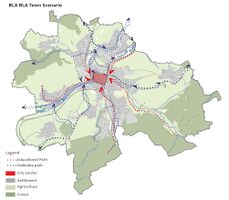
* ''What is your best case scenario for this landscape?'' | * ''What is your best case scenario for this landscape?'' | ||
* ''Present your scenarios in the form of a collage or sketch'' | * ''Present your scenarios in the form of a collage or sketch'' | ||
<gallery caption=" " widths="500px" heights="200px" perrow="5"> | <gallery caption=" " widths="500px" heights="200px" perrow="5"> | ||
File: | File:G2SWOT.jpg|''SWOT diagram of the study area'' | ||
File: | File:Dpsir za wave.jpg| ''DPSIR model of the study area'' | ||
File: | File:G2Forecast.jpg|''Scenario Matrix'' | ||
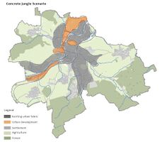
File:G2S2-1.jpg|''Scenario 2 : Worst Case Scenario - Concrete Jungle'' | |||
File:G2S3-1.jpg|''Scenario 3 : Best Case Scenario - Bla Bla Town!'' | |||
</gallery> | </gallery> | ||
| Line 168: | Line 187: | ||
*''Ideally, involve the community of your living labs into this process | *''Ideally, involve the community of your living labs into this process | ||
*''Link back to your original targets from section one and the [http://www.un.org/sustainabledevelopment/sustainable-development-goals/Sustainable Development Goals]'' | *''Link back to your original targets from section one and the [http://www.un.org/sustainabledevelopment/sustainable-development-goals/Sustainable Development Goals]'' | ||
<gallery caption=" " widths="300px" heights="200px" perrow="2"> | |||
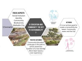
File:G2SQ2.jpg|''Scenario 2 Questions'' | |||
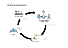
File:G2S2CollaborativeModel.jpg|''Scenario 2 Collaborative Model'' | |||
File:G2SQ3.jpg|''Scenario 3 Questions'' | |||
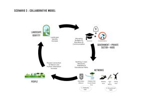
File:G2S3CollaborativeModel.jpg|''Scenario 3 Collaborative Model'' | |||
</gallery> | |||
= Spatial Strategy and Transect = | = Spatial Strategy and Transect = | ||
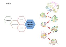
* | * We created a conceptual map for our focal region by combining the potentials and strengths of each scenario. We have productive and sustainable green hotspots, as well as an educational and social community network, all of which are supported by a robust economy and infrastructure.<br> | ||
* | |||
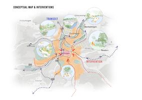
* | * To reflect on our vision for the target region, a transect of interventions at critical spots along the river is given here. Creating accessible public spaces on the water by including decks, chairs, ramps, and steps. Rain gardens will be designed by restoring riparian zones and public nature parks. Such green areas will aid in flood mitigation and improve biotope quality where accessibility is not possible, creating visual links with waterways. | ||
* | Permaculture, climate-adaptive multi-farming, and renewable energy in agricultural regions will be used to enhance long-term food production and community sustainability. <br> | ||
* Public recreational and exhibition spaces near the river close to the historic centre along with educational green corridors running along water thru the town with features like pop-up exhibitions and nature learning will help the community awareness. | |||
Through these small interventions along the river, we have not only a network of landscapes, but also a network of people. | |||
Lateral Learning through community inclusion and from nature is what we have envisioned here. With this network and increased awareness, we can improve the biotope and habitat around the river. <br> | |||
* This strong network will, as a result, help to build the identity in the landscape and community as well. | |||
<gallery caption=" " widths="500px" heights="200px" perrow=" | <gallery caption=" " widths="500px" heights="200px" perrow="2"> | ||
File: | File:S2PotentialDevelopementZone.jpg|''Scenario 2 : Potential Development Zoning'' | ||
File: | File:S3PotentialDevelopementZone.jpg|''Scenario 3 : Potential Development Zoning'' | ||
File: | File:G2Concept.jpg|''Concept'' | ||
File: | File:G2ConceptualMap.jpg|''Conceptual Zoning and Interventions'' | ||
</gallery> | </gallery> | ||
| Line 187: | Line 218: | ||
*''Who needs to act and how? Draw and explain a change/process model/timeline'' | *''Who needs to act and how? Draw and explain a change/process model/timeline'' | ||
*''Which resources are needed? On which assets can you build?'' | *''Which resources are needed? On which assets can you build?'' | ||
<gallery caption=" " widths="500px" heights="200px" perrow="1"> | <gallery caption=" " widths="500px" heights="200px" perrow="1"> | ||
File: | |||
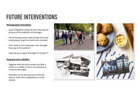
File:G2CommunityActivation.jpg|''Future Community Activation'' | |||
</gallery> | </gallery> | ||
== References == | == References == | ||
* '' | * ''https://de.nailizakon.com/n/01-bw/nurtingen/nurtingen.html'' | ||
* ''https://commons.wikimedia.org/wiki/File:N%C3%BCrtingen,_Andreas_Kieser.png'' | |||
* ''https://www.hochwasserschutz-nuertingen.de/de/naturschutz-umwelt/das-untersuchungsgebiet'' | |||
* ''https://de.zxc.wiki/wiki/Neckar'' | |||
* ''https://de.zxc.wiki/wiki/Flusssystem_des_Neckar'' | |||
* ''https://de.wikipedia.org/wiki/N%C3%BCrtingen'' | |||
* ''https://en.wikipedia.org/wiki/Neckar'' | |||
* ''https://www.hochwasserschutz-nuertingen.de/de/hochwasserschutz-nuertingen/historische-hochwasserereignisse'' | |||
* ''https://www.nuertingen.de/de/nuertingen-fuer-alle/stadt-nuertingen/umwelt/biotopverbund-offenland-nuertingen'' | |||
* ''http://www.fgg-rhein.de/servlet/is/4263/'' | |||
* ''https://udo.lubw.baden-wuerttemberg.de/public/'' | |||
* ''https://www.test-wasser.de/neckar-wasserqualitaet'' | |||
= Process Reflection = | = Process Reflection = | ||
*''Which limitations were you facing?'' | *''Which limitations were you facing?'' | ||
* We confronted numerous difficulties as a result of the existing and pandemic circumstances. For example, reaching a collective agreement on online meetings was extremely difficult because the team members were separated and did not work together, and time management was tough. Due to the absence of the majority of the group members from the site, just two members of the group was responsible for analysis and evaluation. | |||
*''What have you learnt from each other?'' | *''What have you learnt from each other?'' | ||
* Despite our differences of opinion, we have learned to adapt and do our best despite the current challenging position and lack of time. | |||
*''What did you learn in the Living Labs?'' | *''What did you learn in the Living Labs?'' | ||
* We gained some insight into water landscape design from the many presentations and lectures. We also discovered that some waterscape criteria are more significant than others, and we now perceive the waterscape in a more technical light. We learned how to operate together as a group. The talks and topics were also highly intriguing. | |||
*''What would you do differently next time?'' | *''What would you do differently next time?'' | ||
* | * We are attempting to utilize what we have learnt in this live lab and to approach the difficulties in a more professional manner. We also want to involve more people in the design process. | ||
Latest revision as of 11:07, 7 July 2021
>>>back to working groups overview
| Area | Baden-Württemberg | |
| Place | Nürtingen | |
| Country | Germany | |
| Topics | WAVE Project | |
| Author(s) | Yara Karazi, Sara dos Santos Figueiredo, Mahasta Mahfouzi, Rabija Hadzimehmedovic, Israt Jahan Nishat | |

| ||
Rationale
- Nürtingen is a small but important service and economic center in the metropolitan region of Stuttgart, based in Baden Wurttemberg province. The city has developed over the course of the years by the Neckar river, the Rhine tributary, which brings Neckar to an important role of the human society and needs.
- The aspects that were and still are challenging consider the naturality of the river, the floodplains by the settlements, and taking care of the biodiversity. The main goal is to use existing Blue-green infrastructures and restore the local waterbodies like cricks, wetlands, the river Neckar, and its tributaries to reduce flooding risks to adjacent neighborhoods while simultaneously supporting urban agricultural production and wildlife, in addition, to provide recreational benefits to the surrounding community.
Location and scope
You can edit this map with the map editor
Water as a natural system
Geomorphology, typologies and dynamics of water areas
- Describe the water areas of your area in the contxt of the wider water system
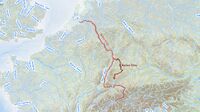
The Neckar River is the tenth largest river in Germany with a length of 362 km. The river begins in the Black Forest the southwest of Baden-Württemberg at an elevation of 706 meters above sea level and flows into the Rhine river at Mannheim, at 95 m above sea level, after passing through the cities of Rottweil, Rottenburg am Neckar, Kilchberg, Tübingen, Wernau, Nürtingen, Plochingen, Esslingen, Stuttgart, Ludwigsburg, Marbach, Heilbronn, and Heidelberg.
- How does water appear in the landscape of your living lab? What types of water areas are common?
Water takes different forms depending on a variety of circumstances, such as typology and the geography of each place. The Neckar River is the most important river in the city of Nürtingen, flowing from almost north to northwest of the city. There are also several small rivers generated by the Neckar River in this city, including the Tiefenbnach Steinach, Aich, Marbach, and Aischenbach. This river, its tributaries, and lakes (standing water) are the common water areas in this living lab.
- Please identify the water bodies' catchment areas, tributaries and floodplains
The Neckar river's catchment area covers around 13,900 km2, with 13,600 km2 in Baden-Württemberg, 300 km2 in Hesse, and a very small portion (15 km2) in Bavaria.
The Neckar river has many tributaries, the longest of which is the Enz with 106 km. Eyach, the Fils, the Rems, the Murr, and the Kocher are some of the other famous tributaries of the river.
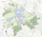
Floods are one of Nürtingen's most significant issues. Areas, where there is a chance of flooding every hundred years, are designated as"flood areas," to which additional laws apply, according to the Baden-Württemberg Water Resources Act.
- Which dynamics do these water areas have?
The height difference between the Neckar River's major source, the black forest mountains, and its destination (the Rhine River), as well as the mountains and plains that it travels through along its course, have a direct influence on the river's flow. Factors like dam construction, canal construction, and the rerouting of branches, in other words, human interference, also have an impact.
- Have there been any flood events in the past?
On the Neckar, particularly significant flood episodes occurred in 1824, 1926, 1978, 1990, and 2013. The historic flood wave that swept across the Neckar in October 1824 was the greatest flood the river had ever seen.
Water as a living space
- Which habitats can be found in and along the water areas of your area?
The left bank of the Neckar in Nürtingen is mostly residential, while the right bank contains the historic part of the city. Seaside trees and farm trees as well as remnants of coastal forests are some of the natural features of the Neckar river in this city.The majority of the Neckar's bank and field trees, as well as the remnants of the alluvial forest, are legally protected biotopes. The woods serve a special function for the scenery and as a habitat for birds and bats, as well as the possibility of wood beetles and dormouse, in an otherwise predominantly urban area. The structure of the water and the flow dynamics of the Neckar have altered dramatically as a result of straightening, embankments, transverse constructions, and other expansion measures, and the densely organized alluvial woods have virtually vanished.
- How is the water quality in your water areas?
Water quality is described as a metric that evaluates the use of water for various reasons (drinking, agricultural, industrial, recreational, and habitat) using physical, chemical, and biological factors. Water quality is important in all areas of life on Earth, attracting the attention of environmental scientists, ecologists, hydrologists, watershed managers, and agricultural experts. The quality of water varies according to location, time, weather, and the presence of pollution sources. In terms of scenery, the transition from tight valley portions to valley broadening is striking. The narrow valleys are mostly caused by the Neckar's sinking into the shell limestone plateau and red sandstone below.The Neckar had excessively high phosphate concentrations along its entire course, according to investigations conducted in 2017. In many places, nitrogen levels are also higher than they should be. Furthermore, the mercury levels in Neckar fish exceeds the standard for environmental quality. Even if the Neckar's water quality is still deplorable these days, the fish and other aquatic life in the Neckar were in far worse shape.
- Which areas are still natural, which are urbanised/artificial?
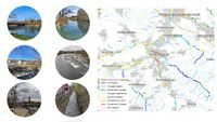
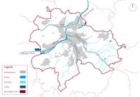
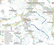
The structure map shows many changes in the water structure of the city. The majority of these changes have been observed in the Neckar River, with only a small portion of the river and its tributaries remaining unchanged. The majority of these changes are caused by building and urban growth. Every day, Baden-Württemberg loses an area the size of seven and a half football fields owing to road and settlement construction! Many near-natural habitats that are vital to animals and plants are also eliminated.
- Are the rivers permeable for fish or blocked by artificial elements?(approx 200 signs)
The banks of the Neckar have been obstructed and the river has been straightened. The weirs in the study region are an issue for the area's ecology. They prevent fish and other aquatic bacteria from migrating. Development has severely limited and diminished the amount of the Neckar's natural floodplain. Dikes and flood protection barriers were created along the river to manage the passage of water and safeguard the houses and other purposes. As a result, natural flooding is nearly impossible. Nature's essential woody structures are restricted to a short area along the embankments. Alluvial forests are uncommon and only exist in tiny areas. The degree of sealing is rather high due to the dense growth, and there is only room for a few natural components. Natural biotope formation is very impossible.
Blue and Green Infrastructure
- What are the major potential elements of a green/blue infrastructure network? Are these likely to change/disappear? Why is that?
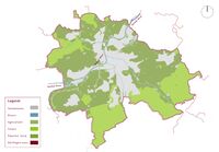
Green Infrastructure, also known as Green and Blue Infrastructure, is a network that delivers "ingredients" from nature's creation to solve urban and climatic challenges while also attempting to improve the quality of life for people and other species. In the city of Nortingen, the green and water infrastructure have undergone many changes due to various factors, including climate change, global warming, and population growth, as well as human interventions such as road and settlement building.
- You find my background material on green infrastructure in our reading list
Water as a cultural space
Land use and water
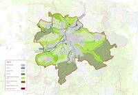
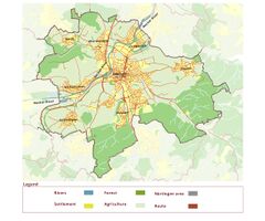
- It is obvious from the maps and analysis that the city has went under many changes. When looking at the historical maps of the settlements and land use it is evident that the sites that are now more industrial before were vineyards, green gardens, green corridors.
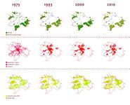
- Nürtingen is under influence of the Sttutgart regional planning which is trying to urbanize the city as well as Neckar river which goes through Stuttgart to Nürtingen. It is more important to have a stable economy rather than green and sustainable landscape. With the development maps from pervious decades, it is evident that the city is getting bigger, more people are getting settled in the vicinity, which brings us to the scarcity of the agricultural and landscape lands.
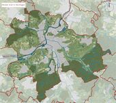
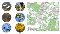
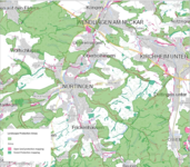
- With the Natura 2000 map of the protection of biotopes and landscape areas, there is still hope that they will try to defy the urbanization that Stuttgart and other regions will undergo. According to future plans, there are some flood protection programs which are especially important since Nürtingen is in a big floodplain. Natura 2000 is an European nature conservation concept based on the EU bird protection directive from 1979 and the FFH directive (fauna = animal world, flora = plant world, habitat = habitat) from 1992. The EU bird protection directive ensures the conservation of all wild bird species in Member States. The Habitats Directive also stipulates the protection of natural and near-natural habitats that are endangered across Europe as well as the occurrence of endangered animal and plant species in front.
Cultural and spatial typologies of water areas
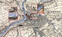
- Neckar was used in many stages and means. From the Andreas Kieser map from 1683 we can conclude that the Neckar and its tributaries were natural and were mostly used in transportation and power supply. Later on the industry added itself to the flow of the river, making Nürtingen some economic prospers. Also it is evident that there were more agricultural lands which directly used Neckar as a mean of supply.
- Looking at the urban morphology of the Nürtingen we can actually concluded that the whole city has developed around and by the river. The St Laurentius Church was the main landmark that was positioned on the hilltop on the east side of the Neckar. In the early years od development, there were more agricultural lands on the sides of the Neckar which later on started being smaller and were taken over the industry and power plant. The houses started nesting around the Aich, Steinach and Tiefenbach tributaries. Tiefenbach suffered most changes since the infrastructure was directly made on top of the river.
Sacred spaces and heritage
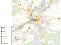
- Nürtingen is a city dating back to the 6th and 7th centuries and with this there are many places and elements of historical value in it, especially in the central part of the city. The central part of the city is located a little bit above the normal level, on a hilltop, which makes this area more historically valuable since every building has survived floods that were happening in the past years. This place a huge role for the identity of the city, bringing it more value to the locals as well as to tourists.
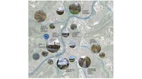
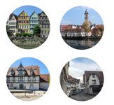
- Some of these historic sites: City Church of Saint Laurentius (Laurentiuskiche): Laurentius is located on a hill by the river Neckar and this is a landmark that dominates the town of Nürtingen. Dedicated to St. Laurentius (St. Lawrence),the original church was probably built in the 10th or 11th century, Historical Old Town: The location of the old town center of Nürtingen on the hill, as mentioned above, overlooking the Neckar Valley, with a far-reaching view over the surrounding countryside and a dominant position over the Neckar crossing, indicates that the original site was of strategic importance, The Town Hall (Bürgeramt), The Museum of Nürtingen (Stadtmuseum) and etc.
Visual appearance and landscape narrative
- The water areas, Neckar and its tributaries, are the ones who shape the landscape and which shaped the Nürtingen in the town it is today. From the simple usage of the river as in transportation means, industrial means, renewable energy, to the pure aesthetical value and relaxation area for the community.
- Famous cartographer, Andreas Kieser, made various maps and paintings trying to depict the landscape and Neckar in Nürtingen. There are also postcards dating from 1907 and later which try to show the character and what the landscape of Nürtingen consists (market, church, historical center, fountain).
- Mark Twain, famous American writer, and Friedrich Hölderlin, German philosopher and poet, depicted the Neckar in rather idyllic way. Mark Twain explained and used Neckar as the inspiration for the A Tramp Abroad: "“Germany, in the summer, is the perfection of the beautiful, but nobody has understood, and realized, and enjoyed the utmost possibilities of this soft and peaceful beauty unless he has voyaged down the Neckar on a raft. The motion of a raft is the needful motion; it is gentle, and gliding, and smooth, and noiseless; it calms down all feverish activities, it soothes to sleep all nervous hurry and impatience; under its restful influence all the troubles and vexations and sorrows that harass the mind vanish away, and existence becomes a dream, a charm, a deep and tranquil ecstasy. How it contrasts with hot and perspiring pedestrianism, and dusty and deafening railroad rush, and tedious jolting behind tired horses over blinding white roads!”. Hölderlin wrote a poem that is called The Neckar: "...The sighs of the poor people into songs, When the pomegranate ripens, when the orange trees, Nod in a green night, and the gum trees drip, Resin, and drums and cymbals resound, To labyrinthine dances. Perhaps someday my guardian deity will bring me, To these islands, but even then my thoughts, Would remain loyal to the Neckar, With its lovely meadows and pastoral shores."
Water and People
Accessibility and usability
- Where are your water areas accessible, and where not? How strong are spatial obstacles preventing access?
- Who is using the spaces and how?
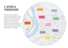
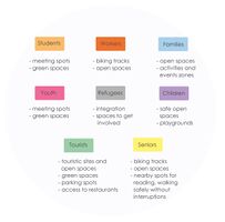
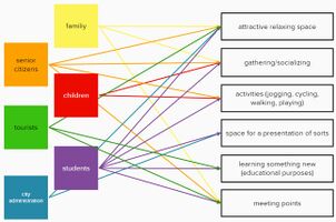
- There are plenty of diverse users around Nürtingen, the community members who are families, children, and senior citizen who loves to do outdoor activities around water areas such as cycling, jogging, walking around, or maybe just enjoy a little picnic in green areas around Nürtingen. We also athletes and fishermen who practices their hobbies around the water areas as well.
Community Mapping
What is to be mapped here?
- Social groups from within the community, for example the youth, kids, students, parents, the retired etc. Typically, these groups have specific needs, which you can also make explicit on the map. These people might not be organized in any way, but they are usually present in the context you are observing
- Local stakeholder groups: these groups are organized in one or the other way. They only exist within the community context you are observing. For example: the local community center, local churches, local interest groups, the landowners, small businesses and retailers
- External stakeholder groups are not necessarily present in the environment you are observing, but they may have strong stakes and interests. These can be local authorities, politicians, associations, care services etc.
- For each group, you may identify their needs, objectives, power and capacities
- You may also identify gaps and power conflicts
- Please try to redepict these elements in an integrated way and in relation to your water landscape. What is the relationship between these groups? Are they close or distanced from each other? Who is more powerful? Which voices are hardly heard? Do they have any shared concerns?
Possible Futures
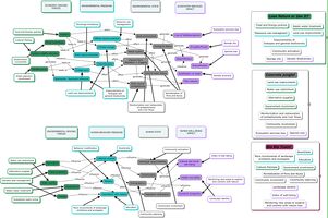
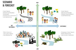
- You can summarize your findings with a SWOT diagram and a DPSI(R) Model
- Link back to the Sustainable Development Goals: Which goals are at risk?
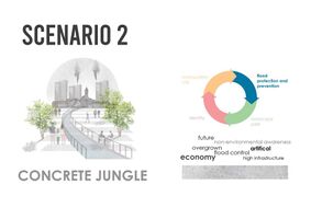
- What is your worst case scenario for this landscape?
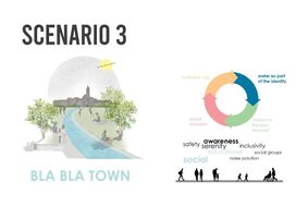
- What is your best case scenario for this landscape?
- Present your scenarios in the form of a collage or sketch
Collaborative Goal Setting
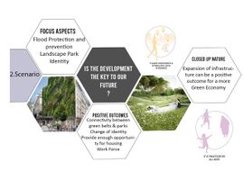
- Define strategic planning objectives based on the evaluation findings from your analysis
- Ideally, involve the community of your living labs into this process
- Link back to your original targets from section one and the Development Goals
Spatial Strategy and Transect
- We created a conceptual map for our focal region by combining the potentials and strengths of each scenario. We have productive and sustainable green hotspots, as well as an educational and social community network, all of which are supported by a robust economy and infrastructure.
- To reflect on our vision for the target region, a transect of interventions at critical spots along the river is given here. Creating accessible public spaces on the water by including decks, chairs, ramps, and steps. Rain gardens will be designed by restoring riparian zones and public nature parks. Such green areas will aid in flood mitigation and improve biotope quality where accessibility is not possible, creating visual links with waterways.
Permaculture, climate-adaptive multi-farming, and renewable energy in agricultural regions will be used to enhance long-term food production and community sustainability.
- Public recreational and exhibition spaces near the river close to the historic centre along with educational green corridors running along water thru the town with features like pop-up exhibitions and nature learning will help the community awareness.
Through these small interventions along the river, we have not only a network of landscapes, but also a network of people.
Lateral Learning through community inclusion and from nature is what we have envisioned here. With this network and increased awareness, we can improve the biotope and habitat around the river.
- This strong network will, as a result, help to build the identity in the landscape and community as well.
From Theory of Change to Implementation
- For implementing your vision: Which partnerships are needed? Which governance model is required?
- Who needs to act and how? Draw and explain a change/process model/timeline
- Which resources are needed? On which assets can you build?
References
- https://de.nailizakon.com/n/01-bw/nurtingen/nurtingen.html
- https://commons.wikimedia.org/wiki/File:N%C3%BCrtingen,_Andreas_Kieser.png
- https://www.hochwasserschutz-nuertingen.de/de/naturschutz-umwelt/das-untersuchungsgebiet
- https://de.zxc.wiki/wiki/Neckar
- https://de.zxc.wiki/wiki/Flusssystem_des_Neckar
- https://de.wikipedia.org/wiki/N%C3%BCrtingen
- https://en.wikipedia.org/wiki/Neckar
- https://www.hochwasserschutz-nuertingen.de/de/hochwasserschutz-nuertingen/historische-hochwasserereignisse
- https://www.nuertingen.de/de/nuertingen-fuer-alle/stadt-nuertingen/umwelt/biotopverbund-offenland-nuertingen
- http://www.fgg-rhein.de/servlet/is/4263/
- https://udo.lubw.baden-wuerttemberg.de/public/
- https://www.test-wasser.de/neckar-wasserqualitaet
Process Reflection
- Which limitations were you facing?
- We confronted numerous difficulties as a result of the existing and pandemic circumstances. For example, reaching a collective agreement on online meetings was extremely difficult because the team members were separated and did not work together, and time management was tough. Due to the absence of the majority of the group members from the site, just two members of the group was responsible for analysis and evaluation.
- What have you learnt from each other?
- Despite our differences of opinion, we have learned to adapt and do our best despite the current challenging position and lack of time.
- What did you learn in the Living Labs?
- We gained some insight into water landscape design from the many presentations and lectures. We also discovered that some waterscape criteria are more significant than others, and we now perceive the waterscape in a more technical light. We learned how to operate together as a group. The talks and topics were also highly intriguing.
- What would you do differently next time?
- We are attempting to utilize what we have learnt in this live lab and to approach the difficulties in a more professional manner. We also want to involve more people in the design process.
