Freising Waterscapes Team 6 2022: Difference between revisions
mNo edit summary |
|||
| Line 33: | Line 33: | ||
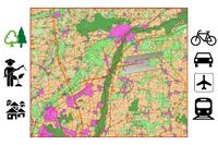
= Location and scope = | = Location and scope = | ||
{{#display_map: 48.394645815734584,11.730039387650407~Moosach | {{#display_map: 48.394645815734584,11.730039387650407~Moosach | ||
| Line 42: | Line 40: | ||
== Geomorphology, typologies and dynamics of water areas == | == Geomorphology, typologies and dynamics of water areas == | ||
''The landscape of the Freising waterscape is defined by the hillside on the northern part of the area. The southern part of the area is a valley. This in large part determines the way of waterflow in the area. The Moosach is a part of the larger Danube watershed.'' | ''The landscape of the Freising waterscape is defined by the hillside on the northern part of the area.'' | ||
''The southern part of the area is a valley. This in large part determines the way of waterflow in the area.'' | |||
''The Moosach is a part of the larger Danube watershed.'' | |||
''Flood risk is a rising threat in the waterscape of Freising. It is clearly visible the projections for a 100-year flood would risk a large part of build upon area.'' | |||
''This needs to be considered for the rest of the project.'' | |||
''The geomorphological story of the area is largely defined by the alps to the south and upstream to the Isar and Moosach.'' | |||
'' | ''The alps create sediments in the area of gravel and larger rocks. The direct influence of the Alps cannot be underestimated.'' | ||
<gallery widths="300" heights="200" perrow="5"> | |||
File:Geomorphology.png | File:Geomorphology.png | ||
File: | File:Hochwasser 100 year in hillshade.png | ||
File:Floodrisk 100 years .png | File:Floodrisk 100 years .png | ||
File: | File:Contours and Hillshade.png | ||
</gallery> | </gallery> | ||
| Line 56: | Line 64: | ||
''All life on earth appeared from water, so it is not surprising that the river Moosach is home to a huge number of plants, animals and other species. And many of them are protected or even endangered.'' | ''All life on earth appeared from water, so it is not surprising that the river Moosach is home to a huge number of plants, animals and other species. And many of them are protected or even endangered.'' | ||
''For example, such as Hungarian gentian, Green shield-moss, Star Swertia for plants; Common Tern, Common Sandpiper, Little Ringed Plover for birds; Moor frog and Danube salmon. All of them need habitats to live and protection. And this should be taken into account when planning the future landscape. The number of the population is growing, as a result of which urbanization is expanding, which can negatively affect habitats and the quality of water.''<gallery | ''For example, such as Hungarian gentian, Green shield-moss, Star Swertia for plants; Common Tern, Common Sandpiper, Little Ringed Plover for birds; Moor frog and Danube salmon.'' | ||
File: | |||
''All of them need habitats to live and protection. And this should be taken into account when planning the future landscape.'' | |||
''The number of the population is growing, as a result of which urbanization is expanding, which can negatively affect habitats and the quality of water.'' | |||
<gallery widths="300" heights="200" perrow="5"> | |||
File:Water as a living space.jpg|Water as a living space | |||
</gallery> | </gallery> | ||
== Blue and Green Infrastructure == | == Blue and Green Infrastructure == | ||
''The blue and green infrastructure in the plan area is significant but fractured. The hillside to the north houses large forest areas with a great variety of species.'' | |||
''There are (extensive) grasslands in the valley and both are of significant proportions.'' | |||
''The Isar river is an extensive line in the landscape with large importance to other natural areas as a green corridor.'' | |||
''The Isar river was planted with alluvial forests for flood control and form a green infrastructure in the landscape.'' | |||
''The problem that arises is the fragmentation of these nature biotopes.'' | |||
<gallery | ''Large roads cut through ecological connections which makes both biotopes more prone to instability.'' | ||
File: | |||
''The grassland areas are located in the middle of intensive farmlands. As these two grasslands have a completely different need for nutrients, these two functions don’t work together.'' | |||
<gallery widths="300" heights="200" perrow="5"> | |||
File:Green and blue infrastructure.png|Green and blue infrastructure | |||
</gallery> | </gallery> | ||
= Water as a cultural space = | = Water as a cultural space = | ||
== Land use and water== | == Land use and water== | ||
''The most of the land of Freising region is covered by farmlands and fields. Munich airport also occupies a fairly large territory.'' | |||
<gallery | ''The forests are mainly concentrated along the Isar river and in the northwest of Freising. There is also a fairly well-developed transport network in the region, both with roads for cars and bicycles, as well as a railway.'' | ||
File: | |||
''Earlier in the past, Freising was a center of trade, but with the development of Munich, the city lost its central role.'' | |||
File: | |||
''Now the leading role in the region is occupied by farms and the food industry, and the presence of the Munich airport also plays a big role in the industrial load.'' | |||
''Water equals life, both for animals, plants, and for humans. It provides a huge amount of ecosystem services:'' | |||
''people use water in all areas of everyday life, for drinking, for washing, for cooking. People swim in the water, they go fishing, use water in enterprises and technologies.'' | |||
''With the development of industry, water was increasingly used in production. In order to plan a sustainable landscape in the future, it is necessary to develop ways to better purify water and limit pollution.'' | |||
''Even with increasing industrialization, it is necessary to maintain a balance between the desires and needs of man and nature.''<gallery widths="200" heights="150" perrow="5"> | |||
File:Land use and water 01.jpg|Land use and water | |||
File:Land use and water 02.jpg|Land use and water | |||
</gallery> | </gallery> | ||
== Cultural and spatial typologies of water areas == | == Cultural and spatial typologies of water areas == | ||
''From the study sections of Moosach, we can see that in the downtown area Moosach was shaped by retaining wall and hardscape. Including the existing of the building, road and plaza.'' | |||
<gallery caption=" " widths="200px" heights="150px" perrow="5"> | ''Section 1 show the hill side, forest and grass lawn beside Moosach. People use this pathway along Moosach for recreation activities. Especially, go for a walk and riding bicycle.'' | ||
''Section 2 show the section on the new development of Moosach. The riverbank become step for people to sit and enjoy. Café put table and chairs beside the river.'' | |||
''Section 3 show the limit area between building. Moosach in that area is about 3 m. wide. And on the right side the building was attached to the river.'' | |||
''Section 4 show a public park with step down to river. People can reach Moosach and enjoy the beauty of nature in the downtown area.'' | |||
''Section 5 show some pathway in the downtown which row of tree and nice atmosphere. Some part of Moosach was shaped by retaining wall and hardscape.''<gallery caption="" widths="200px" heights="150px" perrow="5"> | |||
File:yourcase_water_space1.jpg|''add a caption'' | File:yourcase_water_space1.jpg|''add a caption'' | ||
File:yourcase_water_space2.jpg|''add a caption'' | File:yourcase_water_space2.jpg|''add a caption'' | ||
| Line 99: | Line 132: | ||
== Sacred spaces and heritage == | == Sacred spaces and heritage == | ||
''Since Freising is a very ancient city - 500 years older than Munich, there are quite a lot of protected places and architectural monuments in it, as well as in the surrounding area. The leading role among them, of course, is occupied by churches and cathedrals. The entire Freising center is also an object of historical heritage and protection. There are also a lot protected forests in the area, for example Garchinger Heide and Oberdingermoos.''<gallery caption="" widths="200px" heights="150px" perrow="5"> | |||
<gallery caption=" " widths="200px" heights="150px" perrow="5"> | |||
File:your case_sacredspace1.jpg|''add a caption'' | File:your case_sacredspace1.jpg|''add a caption'' | ||
File:your case_sacredspace2.jpg|''add a caption'' | File:your case_sacredspace2.jpg|''add a caption'' | ||
Revision as of 14:31, 29 April 2022
>>>back to working groups overview
| Area | Freising | |
| Place | Upper Bavaria | |
| Country | Germany | |
| Topics | water areas, landscape, society, public | |
| Author(s) | Anastasiia Puzeikina, Farhin Esmaeilian,
Jaromir Janszen, Pasu Vascharaprakarn, Louisa Schleicher | |

| ||
Rationale
Moosach, a 38 Kilometers long river, is a tributary of the Isar river near Munich, Bavaria, Germany. Moosach, as a main water area of Freising, has played a significant role in characterizing Freising’s landscape for centuries. Recently, urbanization, climate change, population growth, and construction have negatively affected water systems. As a result, study and analysis of the Moosach waterscape would be vital for the river and its influenced area such as environment, nature, society, economy, land use, and settlement.
Location and scope
Water as a natural system
Geomorphology, typologies and dynamics of water areas
The landscape of the Freising waterscape is defined by the hillside on the northern part of the area.
The southern part of the area is a valley. This in large part determines the way of waterflow in the area.
The Moosach is a part of the larger Danube watershed.
Flood risk is a rising threat in the waterscape of Freising. It is clearly visible the projections for a 100-year flood would risk a large part of build upon area.
This needs to be considered for the rest of the project.
The geomorphological story of the area is largely defined by the alps to the south and upstream to the Isar and Moosach.
The alps create sediments in the area of gravel and larger rocks. The direct influence of the Alps cannot be underestimated.


Water as a living space
All life on earth appeared from water, so it is not surprising that the river Moosach is home to a huge number of plants, animals and other species. And many of them are protected or even endangered.
For example, such as Hungarian gentian, Green shield-moss, Star Swertia for plants; Common Tern, Common Sandpiper, Little Ringed Plover for birds; Moor frog and Danube salmon.
All of them need habitats to live and protection. And this should be taken into account when planning the future landscape.
The number of the population is growing, as a result of which urbanization is expanding, which can negatively affect habitats and the quality of water.
-
 Water as a living space

Blue and Green Infrastructure
The blue and green infrastructure in the plan area is significant but fractured. The hillside to the north houses large forest areas with a great variety of species.
There are (extensive) grasslands in the valley and both are of significant proportions.
The Isar river is an extensive line in the landscape with large importance to other natural areas as a green corridor.
The Isar river was planted with alluvial forests for flood control and form a green infrastructure in the landscape.
The problem that arises is the fragmentation of these nature biotopes.
Large roads cut through ecological connections which makes both biotopes more prone to instability.
The grassland areas are located in the middle of intensive farmlands. As these two grasslands have a completely different need for nutrients, these two functions don’t work together.
-
 Green and blue infrastructure

Water as a cultural space
Land use and water
The most of the land of Freising region is covered by farmlands and fields. Munich airport also occupies a fairly large territory.
The forests are mainly concentrated along the Isar river and in the northwest of Freising. There is also a fairly well-developed transport network in the region, both with roads for cars and bicycles, as well as a railway.
Earlier in the past, Freising was a center of trade, but with the development of Munich, the city lost its central role.
Now the leading role in the region is occupied by farms and the food industry, and the presence of the Munich airport also plays a big role in the industrial load.
Water equals life, both for animals, plants, and for humans. It provides a huge amount of ecosystem services:
people use water in all areas of everyday life, for drinking, for washing, for cooking. People swim in the water, they go fishing, use water in enterprises and technologies.
With the development of industry, water was increasingly used in production. In order to plan a sustainable landscape in the future, it is necessary to develop ways to better purify water and limit pollution.
Even with increasing industrialization, it is necessary to maintain a balance between the desires and needs of man and nature.
-
 Land use and water
 -
 Land use and water


Cultural and spatial typologies of water areas
From the study sections of Moosach, we can see that in the downtown area Moosach was shaped by retaining wall and hardscape. Including the existing of the building, road and plaza.
Section 1 show the hill side, forest and grass lawn beside Moosach. People use this pathway along Moosach for recreation activities. Especially, go for a walk and riding bicycle.
Section 2 show the section on the new development of Moosach. The riverbank become step for people to sit and enjoy. Café put table and chairs beside the river.
Section 3 show the limit area between building. Moosach in that area is about 3 m. wide. And on the right side the building was attached to the river.
Section 4 show a public park with step down to river. People can reach Moosach and enjoy the beauty of nature in the downtown area.
Section 5 show some pathway in the downtown which row of tree and nice atmosphere. Some part of Moosach was shaped by retaining wall and hardscape.
-
add a caption
-
add a caption
-
add a caption
Sacred spaces and heritage
Since Freising is a very ancient city - 500 years older than Munich, there are quite a lot of protected places and architectural monuments in it, as well as in the surrounding area. The leading role among them, of course, is occupied by churches and cathedrals. The entire Freising center is also an object of historical heritage and protection. There are also a lot protected forests in the area, for example Garchinger Heide and Oberdingermoos.
-
add a caption
-
add a caption
-
add a caption
Visual appearance and landscape narrative
- Which elements are essential for the landscape character?
- Has the landscape been painted or otherwise depicted, when and whom? Which elements are essential?
- Which narratives exist? Who has written about this landscape or depicted it in some way?
- You can add text and images
-
add a caption
-
add a caption
-
add a caption
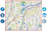
Water and People
Accessibility and usability
- Where are your water areas accessible, and where not? How strong are spatial obstacles preventing access?
- Who is using the spaces and how?
-
add a caption
-
add a caption
Community Mapping
What is to be mapped here?
- Social groups from within the community, for example the youth, kids, students, parents, the retired etc. Typically, these groups have specific needs, which you can also make explicit on the map. These people might not be organized in any way, but they are usually present in the context you are observing
- Local stakeholder groups: these groups are organized in one or the other way. They only exist within the community context you are observing. For example: the local community center, local churches, local interest groups, the landowners, small businesses and retailers
- External stakeholder groups are not necessarily present in the environment you are observing, but they may have strong stakes and interests. These can be local authorities, politicians, associations, care services etc.
- For each group, you may identify their needs, objectives, power and capacities
- You may also identify gaps and power conflicts
- Please try to redepict these elements in an integrated way and in relation to your water landscape. What is the relationship between these groups? Are they close or distanced from each other? Who is more powerful? Which voices are hardly heard? Do they have any shared concerns?
-
add a caption
-
add a caption
-
add a caption
Possible Futures
- You can summarize your findings with a SWOT diagram and a DPSI(R) Model
- Link back to the Sustainable Development Goals: Which goals are at risk?
- What is your worst case scenario for this landscape?
- What is your best case scenario for this landscape?
- Present your scenarios in the form of a collage or sketch
- Add text and visuals
-
explain your analysis briefly in the caption
-
explain your worst case scenario briefly in the caption
-
explain your best case scenario briefly in the caption
Collaborative Goal Setting
- Define strategic planning objectives based on the evaluation findings from your analysis
- Ideally, involve the community of your living labs into this process
- Link back to your original targets from section one and the Development Goals
- 150 words text contribution
Spatial Strategy and Transect
- translate your strategic goals into a vision
- develop a spatial translation of your vision
- exemplify your vision in the form of a transect with concrete interventions
- add map(s) and visualizations
-
add caption here
-
add caption here
-
add caption here
-
add caption here
From Theory of Change to Implementation
- For implementing your vision: Which partnerships are needed? Which governance model is required?
- Who needs to act and how? Draw and explain a change/process model/timeline
- Which resources are needed? On which assets can you build?
- add 150 words text and visuals
-
 add caption here
 -
 add caption here


References
- give a full list of the references you have used for your case
Process Reflection
- Reflect in your intercultural and interdisciplinary team on the outcomes of your study
- Which limitations were you facing?
- What have you learnt from each other?
- What did you learn in the Living Labs?
- What would you do differently next time?
- You can also use diagrams/visuals
- 250 words text