Fusaro Lake WAVE Living Lab 2022: Difference between revisions
Jump to navigation
Jump to search
| Line 47: | Line 47: | ||
<gallery | <gallery widths="200" heights="150" perrow="5"> | ||
File: | File:Index.php?title=File:Yourcase watersystem1.jpg|''add a caption'' | ||
File: | File:Index.php?title=File:Yourcase watersystem2.jpg|''add a caption'' | ||
File: | File:Index.php?title=File:Yourcase watersystem3.jpg|''add a caption'' | ||
</gallery> | </gallery> | ||
| Line 78: | Line 78: | ||
<gallery widths="200" heights="150" perrow="5"> | <gallery widths="200" heights="150" perrow="5"> | ||
File: | File:Immaginee.jpg|Functional and productive assets with existing standards | ||
File:Immagine.jpg|Use and historical structure of the territory | |||
</gallery> | </gallery> | ||
Revision as of 08:51, 25 May 2022
>>>back to working groups overview
| Area | Phlegraean Fields | |
| Place | Bacoli, Fusaro Lake | |
| Country | Italy | |
| Topics | archeological potential, fragmented landscape, water shapes | |
| Author(s) | Cesaro Stefano, De Rosa Vincenzo, Di Caprio Pasquale, Giordano Giuseppna, Reddy Bhavyatha | |

| ||
Rationale
- Lake Fusaro turns out to be a natural element that from the earliest Greek civilizations was essential for anthropic organization and development, today it is not only home to historical cultural heritage but there is a constant development of environments that show a fascinating biodiversity
- The characteristics of the place suggest the possibility of defining a planning according to a type of liveability that is more ecological, social and aesthetically pleasing
Location and scope
You can edit this map with the map editor
Water as a natural system
Geomorphology, typologies and dynamics of water areas
- Lake Fusaro is included in the limits of the municipality of Bacoli belonging to the vast South-West area of Naples called Campi Flegrei, this is a large caldera with a diameter of 15 km whose limits are defined by the Posillipo hill, the Camaldoli hill, the acropolis of Cuma and Monte di Procida, in this circuit there are numerous craters. The Phlegraean word derives from the Greek flégo that is "burn" or "ardo", however, it does not refer to eruptive manifestations since in Roman times the volcano was in a quiet state, the attribute seems to refer to the presence of numerous fumaroles and thermal waters, these forms of hydrothermal manifestations are typical of the locality
- In ancient times, Lake Fusaro was identified with the mythical Acherusia palus (III CENTURY BC) that is the infernal swamp generated by the Acheron river, the local populations cultivated mussels in the lake and oysters today there are mussel farms which are sometimes interrupted due to pollution due to the incorrect disposal of black water and waste
- Please identify the water bodies' catchment areas, tributaries and floodplains
- The Campi Flegrei area appears to be like a lunar landscape, you can see several depressed areas, that is, ancient calderas due to the volcanic activity of the site, some of them were filled with water forming lakes, for example Lake Averno; others, such as the Solfatara, are the expression of the volcanic activity that manifests itself through the fumaroles. In particular, the Fusaro lake was formed with the closure of the stretch of sea between 2 hamlets of Bacoli, Torregaveta and Cuma, today the coast separates the lake from the sea forming an exceptional ecosystem where the typical coastal dune is visible, composed of a variegated spontaneous vegetation called Mediterranean scrub, in addition to the lake it has two water flows that flow into the Tyrrhenian Sea; the origin of Lake Miseno is very similar, that is, separated from the sea by a sandy barrier about 200 meters wide and connected to the sea by two streams.
- In the summer of 2011 and 2017, particular precipitation values were recorded which caused particular and devastating alluvial phenomena in a single day in the area adjacent to Lake Fusaro but were nevertheless episodic events
-
add a caption
-
add a caption
-
add a caption
Water as a living space
- Located north of Naples, in the territory of the municipality of Bacoli, Lake Fusaro was most often classified by geographers as a lago di barra marina. A thin coastal strip separates the lake from the sea forming an exceptional ecosystem of enormous environmental interest in which the typical coastal dune is visible, composed of a varied spontaneous vegetation, the so-called Mediterranean scrub. Along the coastal strip and in the internal part up to the slopes of Mount Cuma it is easy to meet: the zigolo, the chamomile, the rosemary, the holm oak, the strawberry tree, the mastic tree, the alanterno, the juniper, the tamaro, the butcher's broom and the fig of the Hottentots. The brackish lagoon of Fusaro (known since the third century BC as Acherusia Palus) thanks to the presence of fresh water springs, has been able to offer the world superior quality oysters for decades. As for the flora, the habitats of the meadows are located in the surroundings of Lake Fusaro. This type of vegetation was maintained by mowing or grazing. Depending on the state of abandonment, these habitats are slowly and naturally evolving towards more mature forms of shrub vegetation. More precisely, Lake Fusaro was used for aquaculture during the Roman era and still hosts fish and mussel crops. Today, it is affected by the artificialization of most of the embankments, by the presence of the intensive cultivation of mussels and by various sewage drains.
- The waters of the canals are polluted by illegal civil, industrial and agricultural-livestock discharges that cause widespread and uncontrolled pollution. Illegal dumping was only eliminated in 2020, and thanks to its presence for over 10 years, it has contributed significantly to polluting the waters of the lake and the sea. The seabed is covered by a layer of mud made up of mud and soil transported by rainwater and untreated waste water discharges, sea sands, and organic residues of animal and vegetable origin; The legislation provides that the presence in the water of two bacteria, Escherichia coli (which causes colitis) and intestinal Enterococci (one of the causes of diverticulitis of the colon) are considered as indicators of bathing, so if other bacteria or other pollutants would not result from the analyzes. As early as 2008, Lega Ambiente denounced that the new rules would have made even unquestionably polluted stretches of coast suitable for swimming. One of these is, for example, the Roman Beach of Cuma, a beautiful coast with the Regional Forest of Cuma behind it, in whose sea the Cuma Purifier spills water that is anything but clean. Fortunately, the conditions of the Cuma purifier have improved, the situation of the Phlegraean waters has really improved over the years thanks to the two major European projects involving the sewer networks and the Cuma purifier, the situation can really reach excellent levels, but at least for now there it seems really out of place to speak of excellence, when our coasts are battered by waste of all kinds and as long as this precarious balance will always and only depend on the hope that the purifier will not create other disasters.
-
add a caption
-
add a caption
Blue and Green Infrastructure
- The green and blue infrastructures are planned networks, occupied by natural and semi-natural areas of the territory, capable of providing multiple environmental and social benefits but today around the Fusaro lake there are many abandoned and uncultivated green areas that limit accessibility . In general, the area around Lake Fusaro has a great potential that is not fully exploited due to water pollution and the ban on bathing to try to improve the state of the water.
- The municipal authorities are planning to implement a redevelopment plan that provides for the restoration and making available to the public, through a loan, of the Grotte dell'Acqua, a Roman spa complex, and the completion of the works on the adjacent car park to the Vanvitelliano Park in order to accommodate many more people allowing a walk or bike ride from the Cumana del Fusaro station to the Cumana Acropolis passing through the Roman beach.
-
add a caption
-
add a caption
Water as a cultural space
Land use and water
- The Fusaro area is characterized by a landscape with an anthropic / naturalistic character. The purely natural areas are spread around the lake of the same name which communicates with the sea through three mouths; the first to the south, called Foce Vecchia or Romana, is located near Torregaveta, has an 800 m long mouth channel with a 5.5 m span and a depth of 1m; the second in the center of the reservoir is called Foce di Mezza Chiara, and connects the lake and the sea with a 500 m long channel with a span of 10.6 m and a depth of 1m; the third northernmost mouth, Foce Nuova, has a 700 m long outlet channel, a span of 10.6 m and a depth of 1m; the flow rate on each channel is regulated by a series of double gates which are in a serious state of neglect. In the rear part of the Roman beach and near the Torregaveta beach, the vegetation is in the form of high reeds and shrubs which are mainly in a state of neglect and poor maintenance with the exception of the Vanvitelliano Park where the famous Casina is located; in the area there are also a few buildings with a tourist-recreational function in addition to the railway station of Torregaveta and Fusaro of the “Cumana” line. Moving south-east, with respect to the position of the lake, the building becomes increasingly dense, assuming residential-commercial functions until it thins out into agricultural lots in the intermediate part between the Fusaro and the more central area of Bacoli. The only exception is the industrial area of "Leonardo S.P.A." and from the archaeological areas in the area
-
 Functional and productive assets with existing standards
 -
 Use and historical structure of the territory


Cultural and spatial typologies of water areas
- Which spatial patterns have evolved in relation to your water areas?
- What is the role of water areas within the overall urban morphology? (approx 200 signs)
- add 1-2 graphical representations to the image gallery, you can add more if you like
-
add a caption
-
add a caption
-
add a caption
Sacred spaces and heritage
- CASINA VANVITELLIANA The Royal Bourbon casino of Fusaro is a splendid jewel of late Baroque architecture. It was built in 1782 by the architect Carlo Vanvitelli (1739 - 1821), son of the famous Luigi (the author of the Royal Palace of Caserta) commissioned by Ferdinand IV of Bourbon (1751 - 1825), King of the Kingdom of Naples. The residence occupies a small emergence of land within Lake Fusaro and was used as a resting place after the King's hunting and fishing expeditions. With a dodecagonal plan, it is spread over two terraced levels. On the lower floor is the Circular Room, at the time used for convivial meetings and gala evenings. The chapel and the service areas were located in the ambulatory outside the hall. Through a ramp you reach the Noble floor, which could only be accessed by the royal family. A large room, known as the Wonders, welcomes the visitor, where once between a large window and the other there were positioned, in a sort of visual continuity between the external landscape of the lake and the internal one, the four seasons of the landscape painter Filippo Hackert (1737 - 1807). On the main floor there was also a private study and a service bedroom. Later the Royal Casino was used to host illustrious personalities visiting the antiquities of the Kingdom.
- CAVERNA DI CERBERO The function of this channel is still not clear today, but probably to be found in the connection with Lake Fusaro, or simply with a direct connection between the villa and the fish ponds or the Nymphaeums. The entrance cave was imaginatively called "Antro di Cerbero"
- VILLA SERVILIO VATIA The remains of the sumptuous republican villa of the Roman consul Publio Servilio Vatia Isaurico, better known as Servilio Vatia, are located on a tufaceous spur of Torregaveta, a town in the municipality of Bacoli. The saying was well justified by the lifestyle of the rich consul and by the extension of the villa, but also by his definitive retirement to the contemplative life from the active and eventful life in the senate of Rome. The maritime villa, according to historical sources, was of considerable size and even possessed personal fish ponds for the cultivation and supply of fresh fish, as well as spectacular nymphaeum caves. The gastronomic whims of the rich Romans are well known, and the Phlegraean fish products, in particular molluscs and oysters, were very famous products on the tables of characters like Vatia, who probably consumed them all too often. We recall in this regard the oyster beds of Lake Lucrino, which are also depicted on one of the Puteolan flasks Today very little remains of the splendor of the villa: two large rooms covered by a barrel vault with a reticulated structure in opus signinum and covering in opus signinum which served as a water reserve for the villa and sparse traces of the main floor of the villa, disjointed and scattered along the ridge. Furthermore, a vaulted canal is still visible, again in a lattice covered with cocciopesto.
- SALA OSTRICHINA In 1817, the Bourbon king Ferdinand ordered that on the shores of the Real Lago del Fusaro, in front of the Real Casina built in 1782 by Carlo Vanvitelli, a new building, called "l'Ostrichina", be built for the convenience of those who will go to enjoy that Real Site as there is now no place to have lunch. In this factory with a curious name it is perhaps to be identified a first nucleus of the current construction on the shores of the lake, destined to be later modified and accompanied by other building volumes in the beautiful park at the entrance to the site populated by large trees. Responsible for the project and work for the Ostrichina was designated Antonio de Simone, In 1853 the building, located in the park near the shore of the lake, and originally with a central plan and smaller than it is today, it was used, with short success, in a restaurant, and in 1885, renovated and enlarged with a large advanced block body, under new management, reopened to the public. towards the end of the century, following the replacement of some wooden floors with iron beams, a further two-level building was added to the south elevation of the building, assuming the "L" shape given by the aggregation of the two bodies subsequently added and occupying a useful covered area of about 900 square meters, and an uncovered area of 500 square meters. In the fifties, it was further transformed into the structures of the large terraced body with the replacement of its internal masonry arches with reinforced concrete beams and relative replacement of the roof slab with relative adaptation of the three external elevations to the rest of the building. The entire structure, which had been waiting for a radical recovery intervention for years, needed urgent completion works, although some floors and roofs have recently been replaced. Furthermore, the particular planimetric conformation of the large body added on the west side, characterized by the symmetry of the openings, suggested, once the internal dividing walls had been removed and the single-span roof slab replaced, the creation of a large room with flooring in marble of original design in selected marbles (pisanello white, imperial bardiglio, Siena yellow) which gave sobriety and grandeur to the new unitary space of the room.
-
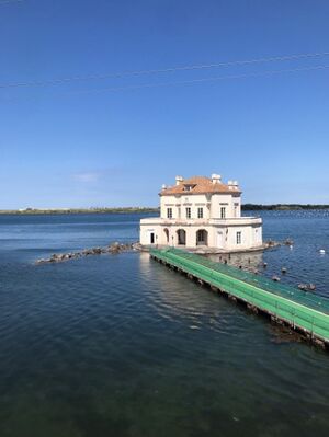
Casina Vanvitelliana -
add a caption
-
add a caption

Visual appearance and landscape narrative
- HISTORICAL TESTIMONIALS Falling within the southern chora (territory) of ancient Cuma (Kyme in Greek, Cumae in Latin), a polis founded by Greek colonists, coming from the island of Euboea, in 730 BC, the Fusaro was for the ancients the Acherusia Palus, the mythical infernal swamp, generated by the Acheron river. The name is attested for the first time as early as the third century. B.C. in the poem Alexandra di Licofone di Calcide (vv.694-709), who defined it as "fluctuating and stormy", perhaps due to the foamy waves generated, in days of bad weather, by the seabed, already low at the time. In the Greek and Samnite ages of the city, in fact, and again in the Roman age, up to the middle ca. of the first century. AD, the basin was likely to have the appearance of a large gulf of the sea, on which it opened completely to the west, a side on which, as the geographer Strabo attests, and if the interpretation is correct, it was nevertheless fordable. The conspicuous remains of the only villa, whose name of the original owner is known with certainty, are located on the small promontory of Torregaveta, located south-west of the lake, almost at the end of the same, are inherent to the maritime villa of Publius Servilius Vatia, an aristocratic Roman character, who lived under the empire of Augustus and Tiberius, of which the writer Seneca speaks, praising the amenity of the site, the beauty and qualities of the villa, but above all praising the choice and style of life of Vatia, who, having abandoned political life, even retired to private life, giving proof of wisdom.
The comparison between the texts of Strabo and Seneca is also noteworthy, the latter describing the narrow beach, which curved between Cuma and the villa, separating the Fusaro from the sea. We thus know that in ca. 40 years elapsed between the death of Strabo (20 A.D.), who described the Acherusia palus, and the visit of Seneca to the villa (60/65 A.D.), the dune bar, now wider, which separates the lake from the sea. After its formation, the water exchange was probably guaranteed to the lake by opening a canal in the center of the west side, since the Foce Vecchia del Fusaro is nothing but a tunnel road, cut into the tuff of the promontory and today submerged in the sea, which allowed access to the villa as a whole from the beach and from the opposite landing place, sheltered by a pier. During the reign of Charles III of Bourbon, Lake Fusaro, together with the funds of the Rocca di Cuma and Lake Licola, was included, as is known, in the extensive royal hunting and fishing site, called "Pineta del Fusaro".
In 1782, during the reign of Ferdinand IV, as part of the building works that embellished the stretch of water, the two Roman rooms, already very much in ruins, were incorporated into the traditional local tuff block walls, still today. visible, although very degraded, in order to preserve and enhance the ancient structures. This was essentially due to the presence of thermal waters, which in the Phlegraean Fields, starting from the Middle Ages, were always used free of charge by the local population for therapeutic use. Oral testimonies, collected in the area by elderly people, in addition to attesting its still recent use, at least until 1930/1940, attributed to these waters, already analyzed in 1967 and defined as the hyperchlorinated-sodium type, virtues connected to the healing of female sterility, through the bathrooms. It is still noteworthy that, in 65/68 A.D., the last years of the reign of Emperor Nero, the lake was included in the project of the Fossa Neronis (Nero's Canal), a navigable canal, which was intended to be 60/65 m approx. , which should have joined the mouth of the Isthmus of Corinth (part of the same project), but abandoned following the revolt of Vindice, had to accelerate the supplies from the East of wheat and other food for the Annona of Rome, to distribute them to the urban proletarian and underclass masses. Finally, the current name of the lake derives, as it seems, from the post-classical deconstruction, also suffered by this area: in the Middle Ages the basin became an infusarium, a place for soaking hemp and linen; the name, from generic, became over time a toponym, Ifosarium, then Sfosarium, in the Angevin age already Fusarium or Fusaria. Fusari were then called in Campania the waterways destined for the maceration of hemp and flax. A document dated 15 May 1122, quoted by R. Annecchino, however, mentions the lake with another name, Laquiluza, a phonetic alteration of the Latin Acherusia, and in the 17th century. the Fusaro even became "Lago della Cosuccia" or "di Coluccio". The scholar from Puteola also related to the memory of Acherusia palus the modern dialectal denomination 'ncopp' or 'nfierno, still given today at the end of the hill of Monte di Procida, which overlooks the Fusaro.
-
add a caption
-
add a caption
-
add a caption
Water and People
Accessibility and usability
- Where are your water areas accessible, and where not? How strong are spatial obstacles preventing access?
- Who is using the spaces and how?
-
add a caption
-
add a caption
Community Mapping
What is to be mapped here?
- Social groups from within the community, for example the youth, kids, students, parents, the retired etc. Typically, these groups have specific needs, which you can also make explicit on the map. These people might not be organized in any way, but they are usually present in the context you are observing
- Local stakeholder groups: these groups are organized in one or the other way. They only exist within the community context you are observing. For example: the local community center, local churches, local interest groups, the landowners, small businesses and retailers
- External stakeholder groups are not necessarily present in the environment you are observing, but they may have strong stakes and interests. These can be local authorities, politicians, associations, care services etc.
- For each group, you may identify their needs, objectives, power and capacities
- You may also identify gaps and power conflicts
- Please try to redepict these elements in an integrated way and in relation to your water landscape. What is the relationship between these groups? Are they close or distanced from each other? Who is more powerful? Which voices are hardly heard? Do they have any shared concerns?
-
add a caption
Possible Futures
- You can summarize your findings with a SWOT diagram and a DPSI(R) Model
- Link back to the Sustainable Development Goals: Which goals are at risk?
- What is your worst case scenario for this landscape?
- What is your best case scenario for this landscape?
- Present your scenarios in the form of a collage or sketch
- Add text and visuals
-
explain your analysis briefly in the caption
-
explain your worst case scenario briefly in the caption
-
explain your best case scenario briefly in the caption
Collaborative Goal Setting
- Define strategic planning objectives based on the evaluation findings from your analysis
- Ideally, involve the community of your living labs into this process
- Link back to your original targets from section one and the Development Goals
- 150 words text contribution
Spatial Strategy and Transect
- translate your strategic goals into a vision
- develop a spatial translation of your vision
- exemplify your vision in the form of a transect with concrete interventions
- add map(s) and visualizations
-
add caption here
-
add caption here
-
add caption here
-
add caption here
From Theory of Change to Implementation
- For implementing your vision: Which partnerships are needed? Which governance model is required?
- Who needs to act and how? Draw and explain a change/process model/timeline
- Which resources are needed? On which assets can you build?
- add 150 words text and visuals
-
 add caption here
 -
 add caption here


References
- give a full list of the references you have used for your case
Process Reflection
- Reflect in your intercultural and interdisciplinary team on the outcomes of your study
- Which limitations were you facing?
- What have you learnt from each other?
- What did you learn in the Living Labs?
- What would you do differently next time?
- You can also use diagrams/visuals
- 250 words text