Lacul Tăbăcăriei Team 1 Living Lab 2021: Difference between revisions
No edit summary |
|||
| Line 21: | Line 21: | ||
| '''Author(s)''' || style="background:Lavender"|''Harcotă Andrei-Bogdan, Bulmagă Iuliana-Vasilica , Nica Mădălina,Gavrilescu Carla, Visterneanu Florentina'' | | '''Author(s)''' || style="background:Lavender"|''Harcotă Andrei-Bogdan, Bulmagă Iuliana-Vasilica , Nica Mădălina,Gavrilescu Carla, Visterneanu Florentina'' | ||
|- | |- | ||
| colspan="3" align="center" style="background:silver"| [[File: | | colspan="3" align="center" style="background:silver"| [[File:Parc-Tabacarie.jpg|400px]] | ||
|- | |- | ||
| ||style="background:Lavender"| | | ||style="background:Lavender"| | ||
Revision as of 09:41, 19 April 2021
>>>back to working groups overview
| Area | Tăbăcărie Lake | |
| Place | Constanța | |
| Country | Romania | |
| Topics | WAVE Project | |
| Author(s) | Harcotă Andrei-Bogdan, Bulmagă Iuliana-Vasilica , Nica Mădălina,Gavrilescu Carla, Visterneanu Florentina | |

| ||
Rationale
- Why do you think this case is relevant? What is your hypothesis considering the landscape challenges?
- Format: 3-4 sentences
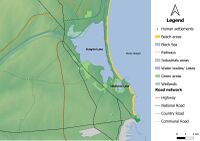
Location and scope
You can edit this map with the map editor
Water as a natural system
Geomorphology, typologies and dynamics of water areas
- Describe the water areas of your area in the contxt of the wider water system
The Tăbăcărie Lake is a natural lake located in the northern part of Constanța and belongs to the Coastal Hydrographic Basin of Black Sea, the lake has an approximately rectangular shape with low shoresand and the banks being covered with vegetation mostly by reed.
Existing water bodies in the area:
1. Tăbăcărie Lake, which has an area of 99 hectares and an average depth of the lake being 1.5m, The lake being located in an elongated depression area helped to creation of the lake by blocking a previously existing river
2. Siutghiol Lake, which has an area of 1900 hectares and the maximum depth of the lake being 17m, The lake is separated from the sea by a coastal cordon. Siutghiol communicates through one artificial channel to Tăbăcărie Lake that is connected with the Black Sea through another artificial channel.
- How does water appear in the landscape of your living lab? What types of water areas are common?
There are two types of water bodies: lakes and artificial channels. The lakes are naturally formed with fresh water, both lakes with an approximately rectangular shape communicating with each other through artificial channels: Siutghiol-Tăbăcărie Canal and Tăbăcărie-Black Sea Canal.
The evolution of Siutghiol and Tăbăcărie lakes is the result of a combination between natural and anthropogenic factors, the climatic factors having a decisive role in the genesis of both lakes.
From a genetic point of view, Lake Tăbăcărie is included in the category of fluvio-marine estuaries. From a sedimentological point of view, the area of Lake Tăbăcărie is related to the evolution of Lake Siutghiol, located to the north, but also to the processes of erosion of the banks of the basin in which it was formed. The shores of the lake are completely rectified and consolidated. The western shore rises to an altitude of 6-7 m and to the eastern and south these elevations are lower, being between 2-4 m. In its northern part, the coast is very low, 1-2 m.
- Please identify the water bodies' catchment areas, tributaries and floodplains
Lake Tăbăcărie belongs to the Coastal Hydrographic Basin, a basin that has an area of about 3958 km2. Along with Tăbăcărie, from the Hydrographic Basin, there are also the lakes Tașaul, Hagieni, Limanu, Techirghiol etc.
The lake is supplied with fresh water from the Siutghiol Liman. It is known that at the bottom of the estuary there are a series of fresh water springs.
- Which dynamics do these water areas have?
Lake Tăbăcărie was surrounded in the last century by the city of Constanța, it directly underwent human interventions, such as dredging, earthworks and heavy pollution. The sediments on the surface of the lake are generally fine-grained: clay and mud, with sands that appear only on the dredged bottoms. Analysis of the chemical composition of the sediment surface revealed the presence of large amounts of certain heavy metals, in particular: Zn, Ba, Cu and Pb, dispersed mainly near the points of discharge of rainwater pipes.
At the level of 1993 in Tăbăcărie Lake, both rainwater and urban wastewater (domestic and industrial), which led to the degradation of the aquatic environment. In the years 1978-1979 the basins of the lake were dredged, and the shore arranged with pedestrian alleys.
Following the dredging works, the highest depths (maximum 3.70 m) were highlighted in the northern part of the lake, where the topography of its bottom has relatively steep slopes due to dredging operations. Initially, the dredging was done evenly throughout the lake, but the supply of rainwater and wastewater, with a large load of solid suspensions, led to the partial clogging of the southern sector. Here are located the most numerous sources of discharge of solid material (sand, gravel), as well as decomposing organic material.
- Have there been any flood events in the past?
The possibility of floods is drastically reduced by the shores that were rectified, strengthened and arranged between 1978-1979 by these anthropogenic changes. The shore was changed by 125 cm above sea level, so that these flood possibilities are almost impossible at present with the shores of the lake "corrected" and with a shape closest to that of the circle.
Between the Siutghiol, Tăbăcărie and Black Sea, artificial canals were built so that the excess water was discharged into the sea by a dam located in the “Pescărie” area (Pescărie area is the north east canal that connects Tăbăcărie Lake to Black Sea).
- add 2-3 graphical representations to the image gallery, you can add more if you like
-
 The water system in Constanța
 -
add a caption
-
add a caption

Water as a living space
- Which habitats can be found in and along the water areas of your area?
Tăbăcărie Lake together with Lake Siutghiol are part of a protected area named „Natura 2000”, The Tăbăcărie lake is a complex lacustrine due to the close interdependence that exists between Lake Siutghiol and Lake Tăbăcărie.
Lake Tăbăcărie hosts an important number of species of reptiles and amphibians, but also protected birds: · 32 species · 43 migratory species · 4 endangered species globally
The vegetation around the lake is specific to Dobrogea Lacustrine, but there are also other species, such as willow, poplar, linden, and some specimens of red oak, magnolia and pond cypress. The flora is represented by shrubs with roses, tulips and other plant species. Hygrophilous plants are also present in the area represented by moisture-loving plants, especially close to the canals and in the slightly swamped areas.
Anthropophilic species are also considered to be adapted to the urban areas, which correlates with the location of the area near urban areas, so that these species have adapted to the presence and human activity.
- How is the water quality in your water areas?
In recent years, the quality of water in the lake has declined, due to the huge amount of wastewater that is discharged without being properly treated beforehand.
The water has been enriched in nutrients, and this leads to eutrophication. The main causes of the eutrophication process are used for mineral fertilizers in neighboring neighborhoods, which eventually contaminate the water, but also the chemical industry that causes nitrogen emissions that react with rainwater and form acid rain, the detergent industry that produces phosphorus salts, but also other wastes that decompose and release nitrogen and phosphorus into the upper layers of water.
The main consequence of eutrophication is huge for the development of planktonic algae that change the properties of water, especially color and odor. Another negative consequence is the decrease in biodiversity and the number of species over time.
- Which areas are still natural, which are urbanised/artificial?
Lake Tăbăcărie is included in the landscape next to Tăbăcărie Park, which is an anthropized environment. It includes “Expoflora” - a permanent botanical exhibition with an area of 4 ha, the Luna Park amusement park, the Dolphinarium together with the Microreservation and the Gravity Park complex. The southwestern part of the park has been considerably reduced with the construction of City Park Mall and related parking lots.
City Park Mall was built in 2008 on a plot of land belonging to Tăbăcărie Park, subsequently a large part of the park was sacrificed to the detriment of construction. This generated protests at the local level, but construction continued; the mall and the parking lot cover an area of about 6 ha
- Are the rivers permeable for fish or blocked by artificial elements?(approx 200 signs)
Every year, in the warm season, The Lake Tăbăcărie suffers due to algal blooms. The process is determined by pollutants discharged into the environment further with the influence of solar radiation causing an increase in the amount of nutrients that come into contact with aquatic plants,causing a sudden increase. The larger the plants, the higher the amount of oxygen consumed. This will lead the fish and the rest of the aquatic creatures to an oxygen deficiency. This will lead to the imminent death of the aquatic species that populate Lake Tabacarie. Another factor that influences aquatic species is the construction of barriers blocking the migration of fish from Lake Siutghiol and then to the Black Sea.
- add 1-2 graphical representations to the image gallery, you can add more if you like
-
add a caption
-
add a caption
-
add a caption
Blue and Green Infrastructure
- What are the major potential elements of a green/blue infrastructure network? Are these likely to change/disappear? Why is that?
The green and blue infrastructure of cities has great potential to effectively address global challenges such as climate change,unsustainable urbanization, the declining access to nature. The green and blue infrastructure can offer multiple social, environmental and economic benefits if put into operation correctly.
The green / blue infrastructure aims to:
Reduce discharges, increase biodiversity that can provide cultural / curative benefits through access to natural resources for the population.
Maintaining health by exposing the population to water.Encouraging a healthy lifestyle, by creating opportunities to practice sports and various exercises (swimming, rowing, walks on the waterfront, etc.).
Maintaining mental health, with the help of the aesthetic aspect of urban waters, which can induce a state of relaxation.
Changes in green infrastructure can happen if planning is inconsistent and does not follow the ideas of a green-blue infrastructure. If these concepts are not followed by the administration of Constanța Municipality, major changes may occur through the ruthless intervention of the City Hall. In conclusion, the disappearance or the change can only be anthropic and influenced mainly by the political class in the city leadership.
- add 1-2 graphical representations to the image gallery, you can add more if you like
-
add a caption
-
add a caption
Water as a cultural space
Land use and water
- describe in particular the historical evolution of land use pattern
More than 100 years ago, in the area of Lake Tăbăcărie were two leather factories, where many locals worked and where skins and furs were processed with a mixture of substances. The book (Constanţa and its surroundings,1960) mentions that: “The lake takes its name from the local industry “Tăbăcăria Mică”, found in these places in 1896. Two years later, "Tăbăcăria mică" ceased its activity. In 1880, on the place occupied today by the building of the maritime research station, it resumed its activity with the name "Tăbăcăria Mare".
13 years ago there was a major change in the use of land. In the premises of the park was built a commercial complex sacrificing a large area 54,000 m2, which is why it aroused protests and controversies before the start construction in 2008.
Following recent changes to the park, it has been found that the ecosystem has been severely affected by human activity which is the biggest cause of habitat loss and natural balance in the life of wild animals that live in the lake and park.
- description evolution, status quo and driving forces, is the land use likely to change? Why is that?
In the past, the use of the land was mainly for industry and for the use of water for leather factories and fish farms in the area. Currently the land use is for recreational purposes being one of the largest green spaces within the city with a fairly high pedestrian intensity compared to other green spaces within the city.
The natural factors that could influence land use would be only flooding or a severe drought. In the current situation, floods are almost impossible due to the shores that have been consolidated but also the canal that Lake Tabacarie is connected with Black Sea through which any excess water is eliminated.
The administrative and anthropic factors that influence the use of land in our study area can be influenced only by the mayor's office. The mayor's office is trying to maintain a balance regarding the satisfaction of investors and the general opinion of the locals, sometimes upsetting one of these two groups.
- add 1-2 graphical representations to the image gallery, you can add more if you like
-
add a caption
-
add a caption
-
add a caption
Cultural and spatial typologies of water areas
- Which spatial patterns have evolved in relation to your water areas?
The spatial patterns that have evolved over time in relation to the water area, are represented by the infrastructure arranged in the park, the promenade alleys, cycling and children's playgrounds. Also, the works of rectification of the banks, correlated with the works of dredging and embankment that led to the change of patterns and evolution to the shape of both the lake and the areas in the immediate vicinity that are closely related to the evolution of the city.
- What is the role of water areas within the overall urban morphology?
Our contemporary landscapes are fragmented with spatially complex patches, in which species of plants, insects, birds, mammals, reptiles and fish have changed significantly from man's case. For example, many native species have declined in abundance as a result of habitat loss and fragmentation. Others, such as invasive species, have grown due to human manipulation. Moreover, functional aspects of ecosystems, such as pollination, seed dispersal, decomposition of dead organic matter, carbon sequestration and water filtration, have also been modified. In recent decades, innovative theoretical and empirical research in spatial ecology has clarified the important roles of landscape, spatial configuration for species interactions and ecosystem processes.
The urban morphological analysis helps in the evolution of the city and maintains a certain coherence on the urban form trying to stop the urban anarchy of unsustainable buildings. Water areas have an important role in the process of formation and transformation of urban spaces. In our case, Tăbăcărie Lake has an important role in creating a recreational space in the context of an urban area, but it also represents a buffer zone between Siutghiol Lake and the Black Sea, with canals that communicate with both bodies of water.
- add 1-2 graphical representations to the image gallery, you can add more if you like
-
add a caption
-
add a caption
-
add a caption
Sacred spaces and heritage
- Which places/elements hold cultural value and to whom?
The church „St. Mina” is a place of worship located on the shores of Lake Tăbăcărie, built between 1995-1997, respecting in the smallest details the traditional Maramures style. In addition to the aesthetic aspect, the church tower is impressive, having a height of 43m, which can be seen from many areas of the city. Built of wood and locally called "Black Church", it is among the tallest wooden churches in Romania. The general style of decoration is Gothic, impressing with its simple beauty and austerity, all the furniture and all the decorative objects being carved in wood.
Soveja Theater is open exclusively in summer, the building being located in Tăbăcărie Park and having a built area of 3,672sqm. Although it is not a very big theater, it hosts famous Romanian and international plays.
The amphitheater in Tăbăcărie Park, a stage for outdoor performances. This name is due to the many shows that take place on that stage. It is sacred because many artists step on the stone "stage". Generally, these shows take place on weekends, when everyone prefers a walk in the park.
The Japanese lamp has been a symbol of the park since 1982, donated by the Japanese city of Yokohama. The lamp would help Constanța and Yokohama make important cultural-educational and economic exchanges. The lamp is made of stone, handcrafted in Kasug style and refers to the ancient Buddhist spirit of the Japanese archipelago. The base and platform are contoured hexagonally and have patterns with lotus petals, the pedestal being cylindrical. The carcass of the lamp is hexagonal, two parts being open to add oil, and the remaining 4 sides being carved with a deer, deer, sun and moon. The roof is all hexagonal with the corners arched upwards. The lamp is placed on a piece of limestone. This style is found in historic Japanese cities and at the entrance to large gardens. The lamp is unique in the country.
-
add a caption
-
add a caption
-
add a caption
Visual appearance and landscape narrative
- Which elements are essential for the landscape character?
The essential elements for the landscape character are:
- The lacustrine environment represented by Lake Tăbăcărie which determined the development around it of the park and leisure activities. Water means life, therefore, the most important influence of the lake on the landscape was the biodiversity of the lake (fish) that attracted the practice of fishing and birds that came for food (swans, cormorants, seagulls, etc.).
- The green areas and recreational areas- Gravity Park, Swimming Training Center,Children Playgrounds and Tăbăcărie Park which stretches around the lake on an area of about 100 ha. The influence on the landscape is reflected by the species of trees and plants that beautify the environment.
- Architecture - the buildings in the immediate vicinity of the lake that are essential from a landscape point of view are the Church “St. Mina ”which has a traditional Maramures style and is decorated in Gothic style, in contrast to the City Park Mall, Ramada Hotel and other modernist buildings.
- Sculpture- Japanese lamp donated by the Japanese city of Yokohama, it is made of stone and handmade in Kasug style and refers to the Buddhist spirit.
- lighting - the lighting system helps to integrate the lake into the landscape.
- Has the landscape been painted or otherwise depicted, when and whom? Which elements are essential?
Elena Moțit, in 1990, made the painting "Pe lacul Tăbăcăriei" in oil on cardboard in which is represented a tourist who practices Windsurfing on Lake Tăbăcărie. In this landscape, one can see a close connection between man and nature.
In the catalog "Litoralul românesc al Mării negre", it was posted in 1980, a view in which a family is represented walking by boat on the water of Lake Tăbăcărie. What caught our attention is the fact that other families are behind, this proves that it was used for tourism at that time.
S. Mendrea, in 1983, took a photo that highlights the riches of the park and Lake Tăbăcărie. The flowers and green space is in contrast with the color of the lake, expressing purity, energy and beauty.
Through these creations, the authors want to highlight the dynamics and beauty of the lake and the Tăbăcărie park.
- Which narratives exist? Who has written about this landscape or depicted it in some way?
So far, no artistic writings have been made about Lake Tăbăcărie, but only scientific ones. The first author to discuss Lake Tăbăcărie is Marian Moise in the book "Constanța Veche" in which he discusses drinking water and the existence of a project for Tăbăcărie Lake who planned to create a water pipe. Thus, people believed that drinking water could be brought from the wells at Palaz,In Lake Tăbăcărie, or from Murfatlar.
Another appearance is in the Strategy for the Development and Promotion of Tourism in the Municipality of Constanța 2007-2020, in which it is described together with the park that surrounds it. It is described as follows: "Tăbăcărie Park is the largest park in Constanța, and one of the largest in the country, with an area of about 100 hectares, which includes Lake Tăbăcărie, fed by underground springs."
Another author who mentions Tăbăcărie Lake is Gheorghe Papuc, in the book entitled “Tomis I, Aprovizionarea cu Apă în Epoca Romană și Romană Târzie” in which he talks about arranging a short canal which connects Lake Tăbăcărie and the Black Sea.
Other mentions of the lake and the landscape have appeared in various scientific articles, such as: (BĂRBULESCU, A,2010)-Modeling Precipitation Influence on Tăbăcărie Lake Water Quality; (SUNDRI, M.I.,2019)-Ecotoxicological Assessment of Tabacarie Lake; (CARAIVAN, G. et al,2009)-Lacul Tăbăcărie- Model de Poluare Urbană.
-
add a caption
-
add a caption
-
add a caption
Water and People
Accessibility and usability
- Where are your water areas accessible, and where not? How strong are spatial obstacles preventing access?
Lake Tăbăcărie is accessible all around, and can be reached from several streets. There are two large boulevards in the immediate vicinity, namely Alexandru Lăpușneanul and Mamaia, but also Soveja Street which facilitates access.
There are no major obstacles, and the buildings adjacent to the lake, although they have occupied part of the access to it, are largely beneficial. Tăbăcăriei Park acts as a buffer zone, from which you can easily walk around to the lake,City Park Mall also help to ease the traffic to the lake area and also the existence of the rectified shores allows the easy access to it, following the route, it can cover its entire surface of the lake.
- Who is using the spaces and how?
First of all, the accessible spaces are used by both the local and the tourists in definition by everybody, kids, parents, teenegers, grandparents, etc.
In general:
- The shores are used by fishermans, runners and people who want to relax and watch the lake.
- The bands are used by bicyclists or joggers.
- The Park itself for picnics, dog walking, walking and sports.
- The Micro-reservation and the Mall for leisure.
-
add a caption
-
add a caption
Community Mapping
What is to be mapped here?
- Social groups from within the community, for example the youth, kids, students, parents, the retired etc. Typically, these groups have specific needs, which you can also make explicit on the map. These people might not be organized in any way, but they are usually present in the context you are observing
- Local stakeholder groups: these groups are organized in one or the other way. They only exist within the community context you are observing. For example: the local community center, local churches, local interest groups, the landowners, small businesses and retailers
- External stakeholder groups are not necessarily present in the environment you are observing, but they may have strong stakes and interests. These can be local authorities, politicians, associations, care services etc.
- For each group, you may identify their needs, objectives, power and capacities
- You may also identify gaps and power conflicts
- Please try to redepict these elements in an integrated way and in relation to your water landscape. What is the relationship between these groups? Are they close or distanced from each other? Who is more powerful? Which voices are hardly heard? Do they have any shared concerns?
-
add a caption
-
add a caption
-
add a caption
Possible Futures
- You can summarize your findings with a SWOT diagram and a DPSI(R) Model
- Link back to the Sustainable Development Goals: Which goals are at risk?
- What is your worst case scenario for this landscape?
- What is your best case scenario for this landscape?
- Present your scenarios in the form of a collage or sketch
- Add text and visuals
-
explain your analysis briefly in the caption
-
explain your worst case scenario briefly in the caption
-
explain your best case scenario briefly in the caption
Collaborative Goal Setting
- Define strategic planning objectives based on the evaluation findings from your analysis
- Ideally, involve the community of your living labs into this process
- Link back to your original targets from section one and the Development Goals
- 150 words text contribution
Spatial Strategy and Transect
- translate your strategic goals into a vision
- develop a spatial translation of your vision
- exemplify your vision in the form of a transect with concrete interventions
- add map(s) and visualizations
-
add caption here
-
add caption here
-
add caption here
-
add caption here
From Theory of Change to Implementation
- For implementing your vision: Which partnerships are needed? Which governance model is required?
- Who needs to act and how? Draw and explain a change/process model/timeline
- Which resources are needed? On which assets can you build?
- add 150 words text and visuals
-
 add caption here
 -
 add caption here


References
- give a full list of the references you have used for your case
Process Reflection
- Reflect in your intercultural and interdisciplinary team on the outcomes of your study
- Which limitations were you facing?
- What have you learnt from each other?
- What did you learn in the Living Labs?
- What would you do differently next time?
- You can also use diagrams/visuals
- 250 words text