Baia Wave Living Lab 2022: Difference between revisions
Jump to navigation
Jump to search
| Line 36: | Line 36: | ||
= Location and scope = | = Location and scope = | ||
''You can edit this map with the | ''You can edit this map with the map editor'' | ||
{{ | {{40.82254987274805, 14.072100341715863}}{{Https://www.google.com/maps/place/80070+Baiae,+Metropolitan+City+of+Naples/@40.8192391,14.0610706,14.48z/data=!4m13!1m7!3m6!1s0x133b1221b88d7361:0xa819a96e38c1003!2s80070+Baiae,+Metropolitan+City+of+Naples!3b1!8m2!3d40.8212236!4d14.0723115!3m4!1s0x133b122}} | ||
}} | |||
= Water as a natural system = | = Water as a natural system = | ||
| Line 50: | Line 49: | ||
<gallery | <gallery widths="200" heights="150" perrow="5"> | ||
File: | File:Screenshot 2022-05-18 102007.png | ||
File: | File:Screenshot 2022-05-18 101911.png | ||
File: | File:Screenshot 2022-05-18 101827.png | ||
</gallery> | </gallery> | ||
| Line 140: | Line 139: | ||
* Please try to redepict these elements in an integrated way and in relation to your water landscape. What is the relationship between these groups? Are they close or distanced from each other? Who is more powerful? Which voices are hardly heard? Do they have any shared concerns? | * Please try to redepict these elements in an integrated way and in relation to your water landscape. What is the relationship between these groups? Are they close or distanced from each other? Who is more powerful? Which voices are hardly heard? Do they have any shared concerns? | ||
<gallery | <gallery widths="500" heights="200" perrow="5"> | ||
</gallery> | </gallery> | ||
| Line 153: | Line 149: | ||
<gallery widths="500" heights="200" perrow="5"> | <gallery widths="500" heights="200" perrow="5"> | ||
File: | File:Possible futures.png | ||
File:Screenshot 2022-05-18 103914.png | |||
</gallery> | </gallery> | ||
Revision as of 09:00, 18 May 2022
>>>back to working groups overview
| Area | Baia | |
| Place | Bacoli | |
| Country | Italy | |
| Topics | Cultural heritage, submerged archeology and volcanic landscapes. | |
| Author(s) | Mohammad Amiri, Eleonora D'Anna, Valeed Abdulhamid, Maria Ferraro, Himanshu Kasera | |
Rationale
- Baia was an ancient Roman town situated on the northwest shore of the Gulf of Naples and now in the comune of Bacoli.
- Area is in the territory of the Phlegraean fields. in the area there are lakes of volcanic origin and coastal lakes originated by barrage. The area is kept humid by the breeze of tryhenian sea which is on the perimeter.
- With a diameter of 12-15 km. In this circuit there are numerous craters and small volcanic elements, some of which present effusive gaseous manifestations.
- FUN FACT : THE LAS VEGAS OF ROMAN EMPIRE 2000 YEARS AGO
Location and scope
You can edit this map with the map editor Template:40.82254987274805, 14.072100341715863Template:Https://www.google.com/maps/place/80070+Baiae,+Metropolitan+City+of+Naples/@40.8192391,14.0610706,14.48z/data=!4m13!1m7!3m6!1s0x133b1221b88d7361:0xa819a96e38c1003!2s80070+Baiae,+Metropolitan+City+of+Naples!3b1!8m2!3d40.8212236!4d14.0723115!3m4!1s0x133b122
Water as a natural system
Geomorphology, typologies and dynamics of water areas
- Complesso archeologico delle Terme di Baia.
- Temple of Mercury
- Tempio di Diana
- Villa dell'Ambulatio
- The Emperor Claudio's Nymphaeum is underwater.
- ARCHAEOLOGICAL MARINE PARK OF BAIA
Water as a living space
- Heritage, Archeological & thermal water are the heritage found near the area.
- industrial waste and illegal structures damaged the water else some restriction has saved it a bit.
- underwater heritage of the area are maintained.
- Your case green blue infrastructure1.jpg
add a caption
- Your case green blue infrastructure2.jpg
add a caption
Blue and Green Infrastructure
- the natural elements anear the are are supposed to be maintained and illegal construction, soil erosion are risk factors across it. pollution is creating need of more the green areas across it.
- Your case green blue infrastructure1.jpg
add a caption
- Your case green blue infrastructure2.jpg
add a caption
Water as a cultural space
Land use and water
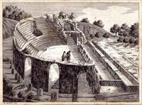
- In the early days of the Roman Empire, Baia, known as "little Rome," became the summer residence of the emperors, thus also the court moved there, and the area became even more luxurious. After Augustus the thermal baths of Baia were extended by Nerone, Adriano, Antonio Pio, and Alessandro Severo, until it became an immense thermal city. Large buildings were built for baths, gymnasiums, libraries, and porticoed gardens. Indeed, porticoes became a feature of the place, supporting the vast terraces that reached out toward the sea, also allowing protection from thunderstorms or the great summer heat. Nowadays remain few original ruins of ancient Baia because of bradyseismic events that have hidden underwater the most valuable and ancient part of the town. Excavations began in 1941, they were interrupted because of the war and resumed in 1950 with Prof. Amedeo Maiuri.
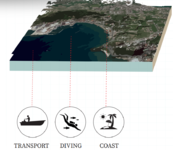
- Even today the coast of Baia is a great resource, not only because it represents a vacation spot for the population but also because with the advent of technological development, tourism has been implemented. Indeed, the port represents both a key resource on a commercial level and a connection point with the islands of Procida and Ischia.
Cultural and spatial typologies of water areas
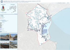
- The ancient roman city of Baia was born along the cost, about 2400 years ago the current port was largely occupied by the mainland, and the promontories of “Punta dell'Epitaffio” and “Punta del Castello” closed forming a basin, called the “Lacus Baianum”. Today a part of this territory is collapsed under the sea because of the phenomenon of bradyseism. This city doesn’t have a regular path and its main area is situated along the coast, where there are the principal commercial activities, the port and an industrial area that contains some abandoned buildings while some others are still in operation. The historical part of Baia is connected to the archaeological one, indeed the little square, which represent the heart of this place, overlooks the Temple of Diana. Moreover, this site is famous all over the word not only thanks to all the roman ruins located on the inner area, but also for the underwater archaeological park, which is one of the favorite tourist destinations. The main street “Via Lucullo” separates the port area form the historical ones and from the agricultural part which is located on the north area of the territory in which residential villages servs plantations.
Sacred spaces and heritage
- Which places/elements hold cultural value and to whom?
- You may add a map and some images, please also explain in your caption why these elements are valuable
- Your case sacredspace1.jpg
add a caption
- Your case sacredspace2.jpg
add a caption
- Your case sacredspace3.jpg
add a caption
Visual appearance and landscape narrative
- Which elements are essential for the landscape character?
- Has the landscape been painted or otherwise depicted, when and whom? Which elements are essential?
- Which narratives exist? Who has written about this landscape or depicted it in some way?
- You can add text and images
- Your case character1.jpg
add a caption
- Your case character2.jpg
add a caption
- Your case character3.jpg
add a caption
Water and People
Accessibility and usability
- The coast is washed by Tyrrhenian Sea and partially occupied by the port, which has a direct access to the sea, in order to simplify the network of harbor transports. The port area is generally populated by locals and tourists which rent boats, especially during summer. This phenomenon causes lots of problems, firstly because these means of transport pollute the waters of the sea and also, because the frequent marine traffic deteriorate the near submerged archaeological remains that lie down the seabed.
- Another part of the coast, instead, is occupied by small fragments of beach, that are interrupted by parkings and restaurants which make it hard to reach the shore. Moreover, the difficulties in accessing are caused by a difference in altitude between the beach and the street that crosses the entire coast; they can be overcome only with flights of stairs and ramps. People use this space not for bathing, because it’s unsuitable for swimming, but to enjoy the beach and take courses for diving to see the underwater remains.
Community Mapping
What is to be mapped here?
- Social groups from within the community, for example the youth, kids, students, parents, the retired etc. Typically, these groups have specific needs, which you can also make explicit on the map. These people might not be organized in any way, but they are usually present in the context you are observing
- Local stakeholder groups: these groups are organized in one or the other way. They only exist within the community context you are observing. For example: the local community center, local churches, local interest groups, the landowners, small businesses and retailers
- External stakeholder groups are not necessarily present in the environment you are observing, but they may have strong stakes and interests. These can be local authorities, politicians, associations, care services etc.
- For each group, you may identify their needs, objectives, power and capacities
- You may also identify gaps and power conflicts
- Please try to redepict these elements in an integrated way and in relation to your water landscape. What is the relationship between these groups? Are they close or distanced from each other? Who is more powerful? Which voices are hardly heard? Do they have any shared concerns?
Possible Futures
- Better water drainage system can be planned and developed around the site to maintain the ecosystem as well as the industrial need of the city.
- soil erosion can be pretended and planned for the areas.
- bad road infrastructure and contours of the area are been affected by the weather.
- the heritage was ignored but it has a potential to generate tourism and create more footfall in this area.
Collaborative Goal Setting
- Define strategic planning objectives based on the evaluation findings from your analysis
- Ideally, involve the community of your living labs into this process
- Link back to your original targets from section one and the Development Goals
- 150 words text contribution
Spatial Strategy and Transect
- translate your strategic goals into a vision
- develop a spatial translation of your vision
- exemplify your vision in the form of a transect with concrete interventions
- add map(s) and visualizations
- Your case spatial translaton vision.jpg
add caption here
- Your case transect.jpg
add caption here
- Your case transect detail1.jpg
add caption here
- Your case transect detail2.jpg
add caption here
From Theory of Change to Implementation
- For implementing your vision: Which partnerships are needed? Which governance model is required?
- Who needs to act and how? Draw and explain a change/process model/timeline
- Which resources are needed? On which assets can you build?
- add 150 words text and visuals
References
- give a full list of the references you have used for your case
Process Reflection
- Reflect in your intercultural and interdisciplinary team on the outcomes of your study
- Which limitations were you facing?
- What have you learnt from each other?
- What did you learn in the Living Labs?
- What would you do differently next time?
- You can also use diagrams/visuals
- 250 words text


