Freising Waterscapes Team 2 2022: Difference between revisions
Jump to navigation
Jump to search
Brent.brug (talk | contribs) |
Brent.brug (talk | contribs) |
||
| Line 73: | Line 73: | ||
=== Habitats === | === Habitats === | ||
*''Which habitats can be found in and along the water areas of your area?'' | *''Which habitats can be found in and along the water areas of your area?''[[File:Biotope map cutout.jpg|none|thumb|Biotopes within the area.]] | ||
(insert text) | (insert text) | ||
Revision as of 12:58, 19 May 2022
>>>back to working groups overview
| Area | River Moosach | |
| Place | Freising | |
| Country | Deutschland | |
| Topics | please enter the main topics of your living lab | |
| Author(s) | Vulnet Abazi, Boglárka Bartus, Brent van der Brug, Dino Jozic and Niusha Vedadi Moghadam | |

| ||
Rationale
- Why do you think this case is relevant? What is your hypothesis considering the landscape challenges?
- Format: 3-4 sentences
Location and scope
You can edit this map with the map editor
Water as a natural system
Geomorphology, typologies and dynamics of water areas
Context
- Describe the water areas of your area in the context of the wider water system?
(insert text)
Water areas
- How does water appear in the landscape of your living lab? What types of water areas are common?
(insert text)
Flood plains
- Please identify the water bodies' catchment areas, tributaries and floodplains
(insert text)
- Which dynamics do these water areas have?
(insert text)
- Have there been any flood events in the past?
(insert text)
- add 2-3 graphical representations to the image gallery, you can add more if you like
(insert text)
- try to use drawings that express the system dynamics
(insert text)
Water as a living space
Habitats
- Which habitats can be found in and along the water areas of your area?
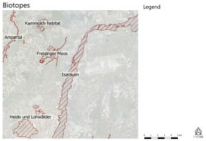
Biotopes within the area.

(insert text)
Water quality
- How is the water quality in your water areas?

(insert text)
- Which areas are still natural, which are urbanized/artificial?
(insert text)
Blue and Green Infrastructure
Blue and Green infrastructure
- What are the major potential elements of a green/blue infrastructure network? Are these likely to change/disappear? Why is that?
(insert text)
- You find my background material on green infrastructure in our reading list
(insert text)
- add 1-2 graphical representations to the image gallery, you can add more if you like
(insert text)
Water as a cultural space
Land use and water
Land-use
- map the land uses along your water areas: settlements, infrastructure, agriculture, resource extraction, natural areas, energy production...
(insert text)
- describe in particular the historical evolution of land use pattern, please make use of historical maps
(insert text)
- description evolution, status quo and driving forces, is the land use likely to change? Why is that? (approx 200 signs)
(insert text)
- add 1-2 graphical representations to the image gallery, you can add more if you like
(insert text)
Cultural and spatial typologies of water areas
Spatial patterns
- Which spatial patterns have evolved in relation to your water areas?
(insert text)
- What is the role of water areas within the overall urban morphology? (approx 200 signs)
(insert text)
- add 1-2 graphical representations to the image gallery, you can add more if you like
(insert text)
Sacred spaces and heritage
Sacred places
- Which places/elements hold cultural value and to whom?
(insert text)
- You may add a map and some images, please also explain in your caption why these elements are valuable
(insert text)
Visual appearance and landscape narrative
Visual appearance
- Which elements are essential for the landscape character?
(insert text)
- Has the landscape been painted or otherwise depicted, when and whom? Which elements are essential?
(insert text)
- Which narratives exist? Who has written about this landscape or depicted it in some way?
(insert text)
Water and People
Accessibility and usability
Accessibility
- Where are your water areas accessible, and where not? How strong are spatial obstacles preventing access?
(insert text)
- Who is using the spaces and how?
(insert text)
Community Mapping
Social groups
- Social groups from within the community, for example the youth, kids, students, parents, the retired etc. Typically, these groups have specific needs, which you can also make explicit on the map. These people might not be organized in any way, but they are usually present in the context you are observing
(insert text)
Local stakeholders
- Local stakeholder groups: these groups are organized in one or the other way. They only exist within the community context you are observing. For example: the local community center, local churches, local interest groups, the landowners, small businesses and retailers
(insert text)
External stakeholders
- External stakeholder groups are not necessarily present in the environment you are observing, but they may have strong stakes and interests. These can be local authorities, politicians, associations, care services etc.
(insert text)
Needs, objectives, power and capacities
- For each group, you may identify their needs, objectives, power and capacities
(insert text)
Power conflicts
- You may also identify gaps and power conflicts
(insert text)
- Please try to redepict these elements in an integrated way and in relation to your water landscape. What is the relationship between these groups? Are they close or distanced from each other? Who is more powerful? Which voices are hardly heard? Do they have any shared concerns?
(insert text)
Possible Futures
SWOT analysis
- You can summarize your findings with a SWOT diagram and a DPSI(R) Model
(insert text)
DPSIR
- Link back to the Sustainable Development Goals: Which goals are at risk?
(insert text)
Worst case scenario
- What is your worst case scenario for this landscape?
(insert text)
Best case scenario
- What is your best case scenario for this landscape?
(insert text)
Scenarios
- Present your scenarios in the form of a collage or sketch
(insert text)
Visualizations
(insert text)
Collaborative Goal Setting
- Define strategic planning objectives based on the evaluation findings from your analysis
- Ideally, involve the community of your living labs into this process
- Link back to your original targets from section one and the Development Goals
- 150 words text contribution
Spatial Strategy and Transect
- translate your strategic goals into a vision
- develop a spatial translation of your vision
- exemplify your vision in the form of a transect with concrete interventions
- add map(s) and visualizations
-
add caption here
-
add caption here
-
add caption here
-
add caption here
From Theory of Change to Implementation
- For implementing your vision: Which partnerships are needed? Which governance model is required?
- Who needs to act and how? Draw and explain a change/process model/timeline
- Which resources are needed? On which assets can you build?
- add 150 words text and visuals
-
 add caption here
 -
 add caption here


References
- give a full list of the references you have used for your case
Process Reflection
- Reflect in your intercultural and interdisciplinary team on the outcomes of your study
- Which limitations were you facing?
- What have you learnt from each other?
- What did you learn in the Living Labs?
- What would you do differently next time?
- You can also use diagrams/visuals
- 250 words text