East Freising Master Climate Change 2022: Difference between revisions
No edit summary |
|||
| Line 334: | Line 334: | ||
*''Which resources are needed? On which assets can you build?'' | *''Which resources are needed? On which assets can you build?'' | ||
*''add 150 words text and visuals'' | *''add 150 words text and visuals'' | ||
One of our prime objectives is to utilize the landscape to improve the people's social, economic, cultural, and recreational functions while considering the environmental, biodiversity, and agricultural needs. The end objective is to turn the landscape into a best-case scenario system that is well connected and sustainable, as presented in chapter 6. | |||
<gallery caption=" " widths="500px" heights="200px" perrow="1"> | Stakeholders throughout the planning, implementation, and evaluation of our goals include; | ||
· The state | |||
· Municipality | |||
· Political bodies | |||
· local communities | |||
· Nature conservation associations | |||
· Farmers | |||
· Residents | |||
· Students | |||
· Education institutions | |||
· Church | |||
· Cultural bodies | |||
· Elderly | |||
· Children. | |||
The steps from theory to implementation will be summarized in the figure below: | |||
To meet the agricultural needs in an environmental and biodiversity manner, the current peatland research station will continue disseminating information about the best puldicultural crops that are of great importance to peatland restoration. These sedges will provide feeds to the livestock of the farmers around. The same sedges can provide energy in terms of biogas and act as a habitat for several areas' biodiversity. Therefore, puldiculture will continue to play various roles within the landscape. The same practice will be introduced to farmers who own land within the peatland area and provide economic incentives to encourage them to adopt the system. The development of puldiculture will also be very vital in turning the peatland into a carbon sink, thereby contributing to the more significant objective of Germany reaching its emission reduction targets by 2050. Therefore crucial players such as the state, municipality, research institutes, universities, and biodiversity agencies will play a key role in rolling out this program further into the community. | |||
Unique places with great recreation potential will be identified, built, and developed to meet the recreational needs of the people. While designing these places, special considerations will be put into acquiring land far from noise, with beautiful scenery to maximize the recreational potential. Stakeholders such as landscape planners, local communities, the municipality will be consulted throughout the process. Once set up, these areas will be periodically maintained and monitored to ensure they operate under the proper standards. In addition to the cool weather, River Moosach will provide a tremendous bird-watching space near the recreational features. Near the recreational sites, people can swill, especially during winter. | |||
Cultural, historical and religious sites within the landscape will be maintained and improved to continue to provide their functions. This explains why the stakeholders from such sites are vital players in site identification and development. | |||
To solve the energy-land conflicts, an Agrophotovoltaic will be set up in the northwestern parts of the project area to provide energy for the residents. The farmers who give up their land for the AgriPV will benefit from the energy, and subsidies but can also grow crops and small rear animals under the PV plant. This project will also reduce greenhouse gas emissions since renewable energy will be supplied to the community. | |||
All the measures mentioned above will be designed in an environmental manner that is not harmful to biodiversity. Places that are habitants for special animals and birds will be considered. Such sites will be mapped out and red zoned hence not tampered with. The red list for biodiversity in Europe will be used to identify the potential habitants for the birds and animals where more emphasis should be put. | |||
The involvement of research institutions, universities, and students will enable the planning process and implementation to bring together a pool of knowledge from different professions such as agriculture, biodiversity, climate change, sustainable resource management, architecture, landscape planning, and forestry. With such a pool of knowledge, the interlinkage between the different sectors will be ensured to be sustainable and balanced. | |||
The realization of the above plan depends on the availability of finances, land, and policies for the planned developments.<gallery caption="" widths="500px" heights="200px" perrow="1"> | |||
File:your case_spatial_your governance model.jpg|''add caption here'' | File:your case_spatial_your governance model.jpg|''add caption here'' | ||
File:your case_spatial_your process model.jpg|''add caption here'' | File:your case_spatial_your process model.jpg|''add caption here'' | ||
Revision as of 16:25, 21 May 2022
>>>back to working groups overview
| Area | The Freisinger Moos | |
| Place | Freising | |
| Country | Germany | |
| Topics | WAVE Project | |
| Author(s) | Pia Röder, Cécile Agustoni, Rok Brišnik, David Abigaba, Juan Miguel Ovalle, Sophia Kremser | |

| ||
Rationale
- Why do you think this case is relevant? What is your hypothesis considering the landscape challenges?
- Climate change is here. What does this mean for our area? Is our area the source or sink? How can we improve the area by using adaptation and mitigation processes in the hydrographic field?
Location and scope
Study area is located 6km west from Freising. Size of study area is 1447 ha. Study area can be seperated in 3 water catchment areas: Sünzhauser Graben, Kleinbacherner Graben and Freisinger Moos.
- Sünzhauser Graben is a parish village with 760 inhabitants, located 6km west of Frising. It layes in Donau-Isar Highland, along west bank of Isar river. It is 455m above sea level.
- Kleinbacherner Graben is a village and parish of Vöting. Vötting was incorporated into Freising in 1937. Former Vötting parishes Gartelshausen, Hohenbachern and Kleinbachern went to Sünzhausen. Neighboring towns are Hohenhachern, Sünzhausen, Pellhausen, Gartelhausen, and Dürnast. Kleinbacherner Graben layes 455m above sea level.
- Freisinger Moos is one of the largest lowland bogs in Bavaria. It measures about 3000ha. It lies in the north of the Munich lowlands, and is the link between the Dachau bog and the Erding bog. It was originally a floodplain of the Isar, along with the Dachauer Moos and Erdinger Moos.
You can edit this map with the map editor
Water as a natural system
Geomorphology, typologies and dynamics of water areas
- Describe the water areas of your area in the contxt of the wider water system
The most significant water feature in the project area is River Moosach, with numerous small sub-tributaries cutting across majorly in the southwestern part. River Moosach is a left tributary of Isar and Amper rivers. Most water features are located in the peatland area, where the water table is higher and the forested areas are in the project area's northern part.
- How does water appear in the landscape of your living lab? What types of water areas are common?
Water within the catchment area flows in small river streams. The river banks have signs of continuous erosion, with soils falling into the main river streams and forming uneven excavations along the river banks. Water appears on top within the peatland area since the water table has risen following peatland restoration measures. However, parts of the peatland where no restoration has been done continue to be wet but with no visible surface water. In some fields, water has been drained to allow farmers grow pasture for livestock. This has created conflicts between the peatland restoration community and the farmers. Whereas farmers are more concerned about viable land for pasture production, draining the peatland and reducing the water table emits more carbon centrally to the objective of the peatland restoration team.
- Please identify the water bodies' catchment areas, tributaries and floodplains
- Which dynamics do these water areas have?
- Have there been any flood events in the past?
The watershed is not prone to floods. However, On the night of June 3, 2013 River Moosach broke its banks following a heavy downpour. This led to flooding of the surrounding areas though mostly agricultural fields in the project area were mostly affected since the settlements are a bit far from the river.
- add 2-3 graphical representations to the image gallery, you can add more if you like
- try to use drawings that express the system dynamics
-
 Surface stream flows of subtributaries of R. Moosach. Photo By David Abigaba 2022
 -
 surface stream flows of subtributaries of R. Moosach. Photo By David Abigaba 2022


Water as a living space
- Which habitats can be found in and along the water areas of your area?
The Fresinger Moos is one of the largest preserved natural areas in Bavaria. The moor is a nature conservation area protected by various decrees. The landscape protection areas in the area are:
- District Ordinance for the protection of the tertiary hills from Maisteig to the city limits of Freising
- Freising County Ordinance on the LSG 'Freisinger Moos and Echinger Gfild'.
There are also two Favna-flora-habitat areas in the area:
- Habitats of the Spotted Salamander in the Kranzberger Forest
- Areas where peat still stands
The Freisinger moos is also a Bird Sanctuaries area. The study area, especially the marsh, is home to many species of flora and fauna. 19 species of fauna in the area are on the Red List, which means that they are threatened with extinction, severely endangered or endangered.
- How is the water quality in your water areas?
The main water source in the area is groundwater. It flows underground from the beginning of the Munich lowlands in the south, towards the Donau-Isar mountains in the north. Groundwater comes to the surface in the north of the lowlands, where it forms a large area of bogs, including the Fresinger Moos. The depth to groundwater in the Fresinger Moos is 7-8m. Water quality is often related to the composition of the soil (rocks and soils). These filter the rainwater, and water percolating through the soil layers also picks up substances from the soil. The Munich Plain is made of gravel left by glaciers when they retreated 10 000 years ago. This deep layer of gravel stores large, easily extractable water deposits. The thickness of the gravel thins to the north, which is why the marshes have formed there. The gravel is covered by a thin layer of humus, which has a low filtering effect. This means that the input of substances in this area has a rapid impact on groundwater quality. In some cases, the water is polluted by agriculture and urbanisation in the marsh area. The depth of the peat in the Freisinger Moos increases in a south-north direction. At the foot of the Donau-Isar, the peat depth is 4-5 m, while in the south it reaches 1-3 m along the Moosach. However, the water quality is good enough for people to drink. The groundwater reservoir of the Fresinger Moos is located 1.5 km south-east of the border of our area. Most of the southern boundary of our site therefore falls within the Class I, II and III water protection buffer zone. Typical for Freising is the mixing of drinking water originating in the forest and drinking water from other areas. Water originating in the forest is of high quality. Mixing improves the quality of water from other areas where it is not of such high quality. The water in Freising district is classified as hard according to the Water Hardness range (water hardness = 16 °dH). This is due to the limestone bedrock. It is therefore important not to use more alkaline sprays in agriculture, so as not to raise the pH and therefore the hardness of the water further.
- Which areas are still natural, which are urbanized/artificial?
There are two small settlements in the northern part of the area. The eastern edge of the area borders on the town of Freising. Due to the proximity of the city, several regional thoroughfares pass through the area. Munchen International Airport is located just 10 km south-east of the site and has a definite impact on the flora and fauna of the area (noise, light pollution, air pollution from kerosene). The southern part of the site is the Fresinger moos, which is a more unspoilt part of the site. The central southern part is bordered by five small bogs (Moosach Weiher), which are located in Water Protection Zone III. In addition to infrastructure, the area has been transformed by agriculture. Arable land covers 40.22% of the area, grassland 29.83% and forest 18.52%. The remaining 11.43% are areas of other uses (infrastructure, water, etc.).
-
 Map: Endangered red list species (author: Rok Brišnik, 2022).
 -
 Picture: Protected grassland to preserve butterflies in Freisinger Moos (author: Rok Brišnik, 2022).
 -
 Map: Peat deepth measurments (author: Rok Brišnik, 2022).
 -
 Picture: Excavated peat profile (author: Rok Brišnik, 2022).
 -
 Picture: Excavated peat profile (author: Rok Brišnik, 2022).
 -
 Map: Impact of the agriculture on the site (author: Rok Brišnik, 2022).


Blue and Green Infrastructure
- What are the major potential elements of a green/blue infrastructure network? Are these likely to change/disappear? Why is that?
Green infrastructure is a water management approach that recovers, protects and mimics the natural water cycle. This goal can be achieved through natural environment and engineered systems. 18.52% (1447 ha) of our area is forested. Only 26ha is in peatland. In the north we have a larger area of Freisinger Forst. This is a mixed stand of oak and beech (70% beech, 30% oak). Age of the forest is above 170 years for oak and above 150 years for beech. Forest was planted on former farmland, therefore this is human made forest, not natural. Beside this comprehensive forest area, we also count forest borders, smaller forest islands and hetches (69 ha). A large part of the area is covered by peatland. In its natural state, the moorland has a positive impact on the water cycle, as it retains flood waters and filters water. Unfortunately, the Freisinger Moos has been largely exploited in the past for peat harvesting, which has greatly altered the moor. The agricultural activity that still takes place on the moor today has lowered the water level, which is again not good from the point of view of the natural water cycle. Nevertheless, the situation in the marsh is improving and restoration is ongoing. The part of the area dedicated to nature protection is increasing, as various stakeholders are buying land for the compensation points system. The nature conservation areas improve the habitat possibilities of flora and fauna, which also have an impact on the natural water cycle through their activities (e.g. paludiculture).
Our area therefore has a number of potentials. The widespread road infrastructure (farm tracks, forest tracks, etc.) offers good opportunities for recreation. To make even better use of it, we should install some more benches, signposts, etc. Recreation areas could find place in already existing forest and field roads. The traffic load of these roads is small, so it is suitable for pedestrians and cyclists. These roads are not paved, so they are not suitable for some forms of recreation. However, care must be taken here not to overburden recreation in the forest and swamp area, as these areas are important for biodiversity. Biodiversity is very diverse, so it is important to preserve it and encourage its development and multiplication. This can be done by maintaining habitat conditions in their natural state and with revitalization of destroyed habitats back to their natural status. The area has many small streams and rivers. It is necessary to ensure that these remain in their natural course or that rivers that have already been artificially dammed are restored to their original state. This moderates the flow velocity, as the water does not flow forward as quickly as through canals, but is retained in the area.
On the other side, we have a lot of artificial pressure on the area. There are few big roads, which connect smaller settlements to each other. There are much smaller roads (forest and field roads), which are used for the purpose of maintenance of foresta and agricultural land. In the area there are few small villages. We need to ensure that settlements will not spread onto agricultural and natural land – preventing land use change. The proximity to the airport, settlements, road infrastructure (minor link roads, motorway) makes the area prone to noise and light pollution. Besides infrastructure there is one another important factor of impact in our area – agriculture. Due to the good soils, the northern part of the area is heavily used for agriculture, with very little uncultivated land. Agriculture uses fertilizers, which pollute the water. Since this is a hilly area soil erosion occurs. Soil is transported to the rivers nearby, which means water gets saturated with silt. One of the main rivers of soil transport in our area is Moosach. Beside this Moosach was already polluted by malachites (disinfectants) from fish farms nearby. Therefore water quality needs to be protected.
- You find my background material on green infrastructure in our reading list
- add 1-2 graphical representations to the image gallery, you can add more if you like
-
 Map: Green and blue infrastructure (author: Rok Brišnik, 2022).

Water as a cultural space
Land use and water
- map the land uses along your water areas: settlements, infrastructure, agriculture, resource extraction, natural areas, energy production...
The hilly area consists of two watersheds. The Kleinbacherner ditch and the Sünzhausener ditch.The third part of our project area is the Freisinger Moos a fen. The catchment area of both watersheds is the Freisinger Moos. Settlements are spread over the hilly areas, whereby the two name-given settlements, Kleinbachern and Sünzhausen lying along the watershed's water axis. A few smaller villages are spread like Haxhausen and Pellhausen. Furthermore, there are individual hamlets, secluded farms and small residential areas. The infrastructure, especially the roads following along the water axis in order to connect the villages with the main road, whereby this main road separates the hilly area from the peatland. As can be seen on the historical maps, the street as a separation between the hills and the plain is old and exists at least since 1857. The location of the road is caused by the difficult soil conditions in the wet areas. Parallel to this road a high voltage transmission line crosses the whole area, to ensure the energy supply of the city of Freising. As well an additional line crosses the peatland.
The agricultural land use depends primarily on the soil and wetness conditions. In the hilly area the places with the best soil and steepness conditions are used more intensively for arable land use, whereby in the steep slopes the grassland usage is more common. A part of the hilly area is also covered by forests and small woody features such as hedges, bushes and scrubs. Natural areas are in general not given. Some parts of the forests and the peatland could still be considered as low managed. There is still more or less natural characteristic vegetation present. The Freisinger Moos is a landscape protection area and includes designated bird protection areas and flora-fauna habitat areas.
Forests provide additional services in the landscape. Besides recreational services, forests reduce emission and noise pollution, protect habitats and landscapes and general resources. Especially the peatland forests containing a historically valuable forest stock. Additional, forests play an important role for soil conservation and climate conservation.
The peatland is predominantly used as grassland with partial extensive pasture use. Despite the humid conditions in this area, drainage allows arable land use partly also intensive. The main area is used for hunting. Groundwater protection playes also an important role in the peatland. For that reason flowering areas are created that provides besides water protection based on the reduction of agricultural use also nature and habitat protection. Partly the peatland is used as compensation area for residential land, commercial areas and roads.
In the peatland area is also a peatland research station located. It is a test facility in the research project 'MOORuse' for the measurement of the CO2 outgassing of the rewetted fen soil with four planting variants in the Freising moss. This is fundamental research for an alternative wetland land use system like paludiculture. Also its contribution to climate mitigation, its environmental effects and profitability is investigated.
The peatland is also an important recreation area for the Freisinger inhabitants. The flat area invites you to walk and cycle. Horse riding trips are also made there.
- On the hills: The Hills were used mostly for agriculture on the sides and Woodlands on top. Woodlands were mostly coniferous (which year is that map?) - used for timber production.
- In the peatland: Freisinger Moos is a fen area, crossed by the river Moosach as the largest flowing waters. Coming from the Freising moss, the Moosach divides into several arms in the city area, some of which humans have artificially created for mills. This huge lowland moor complex was shaped for decades by the use of mowing pasture and peat pits.
- describe in particular the historical evolution of land use pattern, please make use of historical maps
In the first half of the 20th century there were massive interventions in the water balance. But as it was traditionally used extensively until the 1960s, the character of the Freisinger Moos was largely preserved. The landscape is characterized by small-scale peat cutting, litter meadows and a close juxtaposition of various wetland and wet meadows.
The Moosach river at first free is later in a canal. On the map from 1940 it is completely canalized but the process started long before.
The structural change in agriculture, especially since the 60th, has had drastic consequences for the Freisinger Moos. There was a large-scale intensification of land use and the forms of use that had become unprofitable, such as small-scale peat cutting, were abandoned. Willows and bushes started colonizing the no longer mown meadows and peat bogs.
For the last 20 years, the district of Freising and the municipality of Neufahrn bought up fallow sites and renaturalized them
- description evolution, status quo and driving forces, is the land use likely to change? Why is that? (approx 200 signs)
Despite massive interventions in the water balance, which occurred mainly in the first half of the 20th century, the character of the Freisinger Moos remained largely intact, as it was traditionally used extensively until the 1960s.However, the structural change in agriculture also had drastic consequences for the Freising moss. The large-scale intensification of land use, combined with the abandonment of unprofitable forms of use, such as the use of litter meadows to obtain litter, began to change the landscape and its habitats
In order to mitigate the climate change the role of peatland as carbon storage is increasing. That fact leads to the assumption that extension of nature reserve areas, extensive land use or alternative peatland use system like paludiculture might be implemented in the future. These benefit of carbon storage through the peat build up, based on rewetting actions of the drainaged peat areas. As side-effect natural peatland plant vegetation is artificially settled or spreads naturally again.
The main drivers of agricultural land use are the social acceptance, political framework and the change in agricultural subsidies.
As further potential influences, we can mention the water and climate change. A water deficiency and increased temperatures could be dangerous for the water balance of the moor in the future.
- add 1-2 graphical representations to the image gallery, you can add more if you like
-
 The Freisinger Moos is a landscape protection area - Photos by Sophia Kremser, 2022
 -
 Map: Agricultural land use (author: Sophia Kremser, 2022).
 -
 Historical map of the area around 1857 - basis from the BayernAtlas
 -
 Map: Forest Services and building plans (author: Sophia Kremser, 2022).
 -
 Map: Infrastructure and settlements (author: Sophia Kremser, 2022).
 -
 The peatland is also an important recreation area for the Freisinger inhabitants - Photo by Sophia Kremser, 2022
 -
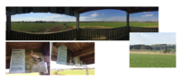 Touristic view facility gives a wide overview of the area and informs the people about the nature protection measures and endangered species - Photos by Sophia Kremser, 2022
 -
 The Hills were used mostly for agriculture on the sides and Woodlands on top - Basis from the BayernAtlas
 -
 Situation on the area around 1890 - Basis from the BayernAtlas
 -
 Situation on the area around 1940 - Basis from the BayernAtlas


Cultural and spatial typologies of water areas
- Which spatial patterns have evolved in relation to your water areas?
The main villages are built along the rivers and brooks. As well the major roads follow along the brooks to the main street to Freising. Connections between the path and drainage water axis development in the peatland are discernible. A connection between temporary water conditions and path development is also recognizable. Caused by the wetness condition no settlements have been developed in the peatland area.
- What is the role of water areas within the overall urban morphology? (approx 200 signs)
The Moos is a place of leisure for the people of the city of Freising. They go there to enjoy the special landscape and nature. The proximity to Freising and the easy accessibility gives it an important role. There are no villages in the Moos, mainly because the ground is wet and unstable. The villages are situated on the hills, near the fields, often along the brooks and rivers flowing to the Moosach and to the Moos. The villages do not have an interesting or important relation to those small rivers, they do not use them. The brooks are often buried under the villages or flow discreetly along the streets and between the fields. They are often interrupted on the map, because they are in part burried. We can see on the BayernAtlas map that the main street in Sünzhausen is situated where the brook probably was. That is in the center of the village, so the village was probably build around it, not next to it.
- add 1-2 graphical representations to the image gallery, you can add more if you like
-
 Map: Settlements and Water (author: Sophia Kremser, 2022).
 -
 Map BayernAtlas: Situation of the Village of Sünzhausen


Sacred spaces and heritage
- Which places/elements hold cultural value and to whom?
Christian wayside crosses line the paths in the whole area. They are still contemporary memorials of Christians and testify to the historical settlement of Christianity in Freising. In addition to the monastery Weihenstephan, the Freising Cathedral st. Maria and St. Korbinian was cathedral church and bishop's seat of the former diocese of Freising is an important part of the historical development history of the region.
The peatland is a reminder of the former peat extraction. At the end of the 18th/beginning of the 19th century, peat appeared in the Erdinger Moos as a cheap fuel and heating material.
Different soil monuments and architectural monuments are also present on our site, as we can see on the Map from the BayernAtlas.
You may add a map and some images, please also explain in your caption why these elements are valuable
-
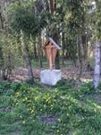 Contemporary memorials of Christians and testify to the historical settlement of Christianity in Freising - Photo by Sophia Kremser
 -
 Monuments on our Area - Map from the BayernAtlas


Visual appearance and landscape narrative
- Which elements are essential for the landscape character?
The Freisinger Moos is a fen and spring fen area. Fens form in river lowlands and hollows at spring outlets. They grow only slightly in height and are interspersed with groundwater, spring water or seepage water up to the bog surface. Their vegetation is species-rich and consists mainly of reeds, rushes and mosses.
The landscape, characterized by small peat cuttings, scattered meadows and a close juxtaposition of different wet and wet meadows, offers habitat for a variety of plant and animal species typical of the fen.
- Has the landscape been painted or otherwise depicted, when and whom? Which elements are essential?
Fritz Halberg-Krauss through his work "Holzfäller im Freisinger Moos" (1942), paint the beauty of the Freisinger Moor landscape. The moss green colour scheme is typical of the natural moor vegetation.The flowing transition of the wet areas to shrubs and forest elements still points to the past only slightly by humans influenced nature and water elements of the landscape.
- Which narratives exist? Who has written about this landscape or depicted it in some way?
- You can add text and images
-
 Fritz Halberg-Krauss, Holzfäller im Freisinger Moos 1942

Water and People
Accessibility and usability
- Where are your water areas accessible, and where not? How strong are spatial obstacles preventing access?
The watershed presents no obstacles to access. The project area is connected by the public road network and can be easily accessed using the public transport system from the city of Freising. In addition, the infrastructure of the area allows access by car as well as by alternative ways of transport such as bicycles, as the area is interconnected by a network of internal roads that facilitate mobility between settlements.
- Who is using the spaces and how?
The predominant land use in the landscape area is due to farmers who cultivate the land for the production of agricultural products. Most of the land is extensively used as grassland, although a few farmers also keep cows or horses. The areas that are not used intensively, i.e. those that are more natural, are used by local residents as recreational areas. These are mainly renaturalised and partially rewetted moorland areas. The population also protects their private green spaces, thus contributing to the preservation of the rural character of the project area and its villages. In addition, there are some monuments which not only have a potential for tourism, but are also educationally valuable for all those who use the landscape area. The moorland can also be seen as such a monument, because it has formed over centuries and many rare plants live in it. These, as well as the soil, can tell their users stories about the years gone by when they take a closer look. In addition, and due to the different research projects of the Bavarian Forestry Administration the area is frequently visited by university students of the Hochschule Weihenstephan-Triesdorf and Technical University of Munich respectively.
-
 Map: Road transport and path (author: Juan Miguel Ovalle, 2022)
 -
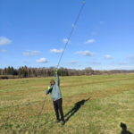
 Climate change master students in the project area - Photo by Rok Brišnik, 2022


Community Mapping
What is to be mapped here?
As already mentioned, the farmers in this area are one of the main actors, they are strongly rooted in this area and are to a large extent also dependent on it. However, there are not only farmers who have an interest in the area. There are also other interest groups, which are presented below and introduced in more detail.
These stakeholder groups were categorized for the project area as follows:
As already mentioned, farmers are a large stakeholder group. They also have a great deal of decision-making power over this land, as they are the owners of it. As already written, farmers are dependent on the land as it secures their livelihood and they derive their income from it. However, this group is in conflict with other groups because they do not use the land as other groups would. There is therefore a need for a compromise between the groups.
The next interest group is the city of Freising and the other neighbouring municipalities. They are the controllers of the area; the law gives them the power to do so and they are the most powerful influencers in the area. They consist of: Municipality, State and Representatives. Their power is absolute because they have control over the town, however, it should not be forgotten that their role is to help the community live a better life. They are the less distributed actors in the city, their number is not large, but on the other hand their power is not limited to one area. The city of Freising has a drinking water protection area in the project area and is therefore interested in the protection of the area, as well as ensuring that no pollutants are introduced into the area. Thus, their needs are also significant, because they are not only interested in protecting the moor from the point of view of drinking water protection, but also want to keep it as a recreational area. As this group is not organized, it does not have a high level of acceptance. Nevertheless, the acceptance of this group is very important because only in this way can projects be realized. The group's goal is to be able to realize all their projects and thus satisfy their needs. The higher the acceptance, the easier it is to realize projects and the less potential for conflict.
Residents are also a group that cannot be ignored. They are the main users of the area and one of the most important influencers in the area they are made up of: Children, Elders, Students, Working Class and Youth. They are present in every area, but unlike other groups, they are powerless. However, one possibility would be to invite them and ask for their opinion and feedback. This way, more ideas could be collected and the main users of the area could also be involved in decision-making processes.
Another group are the nature conservation associations active in the area, such as the "Bund Naturschutz", "Landesbund für Vogelschutz und Landespflegeverband". These associations are also interested in the protection of the moors. For example, they want to renaturalise moor areas and then protect and maintain them so that species worthy of protection can spread here again. The group also has another interest in protecting peatlands, because when they are used and drained, they emit CO2. Actually, the moor would absorb and store CO2, but when the water balance decreases, this process is reversed. Thus, the issue of climate change is very present for this group and also a strong motivation to realise projects. This group has a high level of acceptance among the population due to their broad knowledge and because they support climate protection. The sovereignty of the nature conservation associations is, however, limited to their own areas, but their aim is to enlarge and increase these in order to further help the protection of the peatlands. However, they are dependent on other stakeholders for this endeavour, as they need funds for its realisation.
Another group that should not be ignored are the educational institutions. For example, the Weihenstephan-Triesdorf University of Applied Sciences. This has an institute for ecology and landscape, as well as an ongoing project called MoorUse on the area. The interest of this group is to keep the areas they already own and also to use other areas for research. This group can cooperate with the farmers' group because of their broad knowledge, because they have the possibility to build a sustainable agriculture that is better for the climate than the traditional land use. They could be a key group in resolving the conflict of protecting the peatlands while still allowing them to be farmed. The power of this group is relatively low and the interest only correlates with the carbon storage value, yet the interest in this value is very high.
In the last interest group, the others, several smaller groups have merged into one. They are connected to the mire but have no interest in changing its use. These include, for example, church groups that care for nature and the airport, which uses the Freisinger Moos as a flight path, but is not interested in the areas themselves.
-
 Graph: Interest conflicts (author: Pia Röder, 2022)
 -
 Graph: groups in their rankings (author: Pia Röder, 2022)
 -
 Graph: Institutions (author: Pia Röder, 2022)
 -
 Graph: participation opportunity in the project area (author: Pia Röder, 2022)


Possible Futures
Four important sustainability goals have been defined for the possible change of the area in the future:
- Establish sustainable agricultural practices in which nature and landscape can coexist.
- Renaturalise individual areas of the moorland and transform it from a carbon emitter to a carbon store
- Create a habitat for endangered species
- Preserve and promote the landscape as a recreational, research area
These self-defined sustainability objectives are intended to help guide the development of the project area towards the best-case scenario and to exclude, as far as possible, development towards the worst-case scenario.
Best-case scenario: (Sustained & Connected) - The best-case scenario is the ideal of the outcome of the development over the years on the project area. Here, people live in harmony with the moor, and nature and agriculture have harmonized with each other. This has also led to the moors regaining their original function as CO2 reservoirs. Which is essential for the fight against climate change. Which also supports research in the area and makes it possible to continue. The landscape has also been significantly improved by the redevelopment and now serves as an excellent recreational space for the citizens.
The worst-case scenario (Collapsed &Connected) is meant to show the worst course in the change of the landscape. In this case, this means that the intact peatlands have completely disappeared and the landscape has been exploited by even more intensified agriculture and ever faster climate change. The pictures in the 'forecast' graphic are meant to illustrate what the landscape could look like. What cannot be visualized, however, is the enormous increase in CO2 in the air that has taken place as a result of the exploitation. This outcome makes it impossible to slow down climate change. On the contrary, it will increase even more rapidly and make life on earth impossible in the not-too-distant future.
The two intermediate forms (Collapsed& Fragmented/ Sustained & Fragmented) should further illustrate the other developments. In both forms, development is neither particularly good nor very bad. However, these two forms are not to be strived for, because they will neither serve to stop climate change nor to increase farmers' yields.
- You can summarize your findings with a SWOT diagram and a DPSI(R) Model
- Link back to the Sustainable Development Goals: Which goals are at risk?
- What is your worst case scenario for this landscape?
- What is your best case scenario for this landscape?
- Present your scenarios in the form of a collage or sketch
- Add text and visuals
-
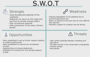 S.W.O.T Analysis (author: Pia Röder, 2022)
 -
 Forecast (author: Pia Röder, 2022; Pictures: Ludger Frye 2012 (NABU), Christian Fischer 31. Dezember 1986)
 -
 DPSI(R) Model (author: Pia Röder, 2022)
 -
 Scenarios (author: Pia Röder, 2022)


Collaborative Goal Setting
- Define strategic planning objectives based on the evaluation findings from your analysis
- Ideally, involve the community of your living labs into this process
- Link back to your original targets from section one and the Development Goals
- 150 words text contribution
Our current analysis of our study area has allowed us to determine, at least qualitatively for Freisinger Moos, that the area faces problems due to the drainage of the peatland areas, which has generated progressive deterioration of the peatland zone. Such deterioration may get worse in a context of climate variability. Therefore, the East Freising Master Climate Change 2022 working group has determined that the strategic objectives will focus on actions to prevent deterioration of peatland conditions and restoring compromised peatlands respectively. Additionally, actions for forest adaptation will be determined, and voluntary protection of peatlands by different stakeholders will be an integral part of our strategic objectives.
- Growing highly-productive bioenergy crops: Restitution of current crop area in biomass production areas through paludiculture.
- Rewetting peatland: A drained peatland means a large CO2 emissions. Rewetted peatlands become CO2 sinks, the faster and larger benefits of peatland rewetting result from the avoidance of CO2 emissions from drained peatlands.
- Adaptation of forests: . Longer drought periods and decreasing rain make it imperative to look for adaptable species.
- Voluntary Restoration: Peatland restoration and protection will be required collaborations between different stakeholders nonprofits, local governments, and farmers to advance in the ecosystem functionality recovery.
Spatial Strategy and Transect
- translate your strategic goals into a vision
Just observe the area through environmental goggles. As we are well aware of climate change, our vision is to adapt the area in such a way that it will be resilient to climate change in the future. We have different scenarios for climate change. SRES scenarios (A1, A2 - climate worst, B1 - climate best, B2), SSP scenarios (1.9 - climate best, 2.6, 4.5, 7.0, 8.5 - climate worst). The adaptation of the area depends on the scenario we consider. We will not go into too much detail ourselves, but will present the vision as one scenario for climate change. Two aspects of change are important in the transformation of an area in the context of climate change. The first is that the area needs to be transformed so that it is no longer an environmental burden / source of emissions, but a sink of emissions. This can be achieved by restoring the wetland, transforming the forest and transforming agricultural use. The second change is to adapt the area to climate change so that it is resilient rather than vulnerable. Here, we are aiming primarily at planting crops and forest species that are resistant to higher temperatures and lower water levels.
- develop a spatial translation of your vision
1. Restoration of bogs: drainage of bogs is one of the biggest air pollutants. 3% of the territory contributes 50% of the CO2 in the atmosphere and feeds 25%-33% of world soil carbon. Bavaria has committed to restore 55,000 ha of bogs by 2040. As the Freisinger Moos is one of the bogs in Bavaria with the highest greenhouse gas emissions to the atmosphere, it would be highly recommended to restore the Fresinger Moos back to its original natural state. This means raising the water level in the marsh. This includes the closure of drainage ditches (artificial or natural - beaver), paludiculture (plants naturally raise the water level) and minimal negative anthropogenic interference in the area. Such a change would not only have positive effects on the climate, but also positive effects on biodiversity. As this extreme nature conservation option is unlikely to be implemented, for economic reasons (agriculture), we propose a middle way. Extensive agricultural land use in the marsh area. This would mean changing the water level in the soil throughout the year. During the winter, when farmers do not use the land, the water level rises. During the growing season, however, the water level is lowered to make the soil suitable for extensive agricultural production. Extensive means that the grass is not mown excessively (maximum 1 time per year) and that fertilizers are applied according to the rules.
2. Forest is a large carbon sink. In the study area, the 236 ha forest stores 45.6 kt of carbon and the 69 ha small woody features store 1.7 kt of carbon. In total 47.3 kt of carbon. Although this is only a small proportion of carbon sequestration compared to emissions (for comparison, Germany emitted 194 million tonnes of carbon in 2019), forest management is an important factor in the fight against climate change. In this context, we have a range of approaches that can help. One of these is the replacement of conifers by deciduous trees. In the forest studied, deciduous trees store 3 times more carbon than coniferous trees (314.4 C t/ha for deciduous trees, 120.6 C t/ha for coniferous trees). In addition to storing carbon, it is also important for the forest to be transformed so that it can withstand higher temperatures and less rainfall. It is important to plant thermophilic varieties in the forest, to ensure that the age and biodiversity of the forest is diverse and that the end products of the forest are used in sectors that store carbon and do not release it into the atmosphere (construction, furniture, etc.).
3. Agriculture: at first, one does not think that agriculture can have a significant impact on climate change. But this is not the case. Agriculture has a great weight in the fight against this issue. The first thing is soil. Soil stores large amounts of carbon. It is therefore important to make sure that the soil stays where it is and does not erode out of the area, because that releases carbon into the atmosphere. Soil erosion can be reduced by adapting agricultural management. Another important thing in agriculture is what types of crops we plant. In order to combat climate change, it will be necessary to plant drought-adapted crops. It will also be necessary to plant water-saving crops, because access to this resource will be different in the future. Water will have to be stored for drinking. Fertilization should be mentioned here, as reckless use endangers groundwater. Here we propose a reduction in intensive farming, which uses large amounts of fertilizer and rotates crops so that soil erosion is higher. Extensive farming would also help to improve biodiversity. Farmers need to be educated about this and offer help if needed.
4. Energy: Germany wants to be carbon-free by 2045. This will require an increase in renewable energy capacity. Our area is not suitable for wind energy, due to the proximity of the airport, which prohibits the use of wind turbines in their vicinity. Our area is suitable for photovoltaics in open areas - i.e. agricultural areas. Installing PV would automatically mean extensive grass cutting in these areas. This would have a positive impact on biodiversity. Of course, we must make sure that the solar panels are installed in the way that the regulations say they should be installed in order to achieve positive effects for fauna and flora. Photovoltaics can also be installed in the marsh area. We advise against the production of crops for biofuel, as the same amount of electricity produced by solar panels for biofuel would require an area 14 times larger.
5. Recreation: as already mentioned, the area is very suitable from a recreational point of view. It is close to the city. Green spaces and infrastructure already exist. The only improvements needed would be to improve the infrastructure and to extend the green areas for recreation.
- exemplify your vision in the form of a transect with concrete interventions
The study area is affected by different uses and the needs of different stakeholders. This can lead to disagreements and conflicts in the designation of land. In order to best satisfy all stakeholders and to be consistent with the transition to a green future, we have decided to make certain interventions and changes to the area.
Peatland: this area has a high proportion of biodiversity and habitat diversity. Also, the way the wetlands are managed has the greatest impact on carbon emissions or sequestration. We have therefore identified this area as a nature conservation area. We would prohibit intensive agriculture. Extensive farming would be allowed and would be supervised by experts (to ensure that no infringements occur). Pipes would be installed under the farmed fields to allow the water level to vary throughout the year (high water in winter, low water in summer - so that the farmer can cultivate the area). Part of the area would be dedicated to paludiculture. These plants naturally raise the water level. Paludiculture would not be used for biogas, but photovoltaics would be installed in the same area. The reason for this is that it takes 14 times more land for biofuel than photovoltaics to produce the same amount of energy. The wetland shall also be developed for recreational purposes. This means that the agricultural paths are equipped with direction signs for visitors. Benches and educational boards are to be placed at certain locations to inform visitors about the importance of the area for nature.
Forest: the forest needs to be transformed. Currently the ratio of deciduous to coniferous trees is 39:61. Our plan is to reverse this figure. The ratio of deciduous to coniferous trees should be 70:30. It is important to place deciduous trees at the edge of the forest to prevent deforestation due to drought. Although the Kranzberger Forest is suitable for wind farms, we would not place them in the forest, as their construction would destroy too much of the area. This would leave parts of the forest open and therefore more exposed. There are already some forest roads through the forest. The larger ones could be used for recreation. Direction signs for cyclists and pedestrians should be erected. A forest nature trail and a forest recreation trail with an outdoor fitness area could be made, fragmented by points (a certain type of exercise in one place rather than the whole fitness area together). The forest would not be used for planting tree species for energy, as it is protected as a nature conservation area due to the amphibian habitat.
Agricultural areas: these areas would be retained for agricultural use. However, farmers would be advised to adapt their agricultural use. As this is a hilly area, areas with a higher slope are prone to erosion. Erosion would be reduced by the following adjustments:
- Agroforestry: narrow lines of woodland between arable fields moderate erosion if the direction of cultivation is in the direction of the stratification lines. Reduce erosion by up to 70%.
- Grass waterways. We have calculated on which parts the erosion power is highest. We recommend using grass waterways there, as the grass redistributes and attenuates the flow of water so that erosion ditches do not form.
- Cover crops: reduce the erosion level by 26.2%.
- Crop rotation
- No tillage: reduces erosion levels by 47.8%.
Our aim is to increase the carbon content of the soil (SOM) and to increase biodiversity also in agricultural areas. This is achieved by less soil disturbance, such as no tillage, which does not expose the top layers of the soil. SOM and biodiversity are also increased by changing land use from arable to grassland.
Water areas: water areas are already largely modified by humans. Therefore, we have identified the conversion of artificially trapped watercourses back to natural watercourses as a measure. This is particularly important in the marshes. Drainage ditches will remain important for regulating the water level, but we must not allow this water to run off too much. The marsh banks would be greened and planted with shrubs and trees (not just grass) to encourage the development of biodiversity.
- add map(s) and visualizations
-
 Areas for green transformation (author: Rok Brišnik, 2022):
 -
 Forest structure transformation (author: Rok Brišnik, 2022).
 -
 Construction of a trim track along the already existing infrastructure. Points with exercise aids would need to be constructed (author: Rok Brišnik, 2022).
 -
 Transformation of intensive agriculture to extensive mixed agriculture (author: Rok Brišnik, 2022; source: Euractiv, 2022).
 -
 Map of energy potential in project area (authors: CCM students, 2022).
.png)


..png)
..png)
From Theory of Change to Implementation
- For implementing your vision: Which partnerships are needed? Which governance model is required?
- Who needs to act and how? Draw and explain a change/process model/timeline
- Which resources are needed? On which assets can you build?
- add 150 words text and visuals
One of our prime objectives is to utilize the landscape to improve the people's social, economic, cultural, and recreational functions while considering the environmental, biodiversity, and agricultural needs. The end objective is to turn the landscape into a best-case scenario system that is well connected and sustainable, as presented in chapter 6.
Stakeholders throughout the planning, implementation, and evaluation of our goals include;
· The state
· Municipality
· Political bodies
· local communities
· Nature conservation associations
· Farmers
· Residents
· Students
· Education institutions
· Church
· Cultural bodies
· Elderly
· Children.
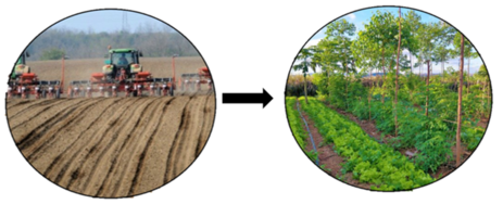
The steps from theory to implementation will be summarized in the figure below:
To meet the agricultural needs in an environmental and biodiversity manner, the current peatland research station will continue disseminating information about the best puldicultural crops that are of great importance to peatland restoration. These sedges will provide feeds to the livestock of the farmers around. The same sedges can provide energy in terms of biogas and act as a habitat for several areas' biodiversity. Therefore, puldiculture will continue to play various roles within the landscape. The same practice will be introduced to farmers who own land within the peatland area and provide economic incentives to encourage them to adopt the system. The development of puldiculture will also be very vital in turning the peatland into a carbon sink, thereby contributing to the more significant objective of Germany reaching its emission reduction targets by 2050. Therefore crucial players such as the state, municipality, research institutes, universities, and biodiversity agencies will play a key role in rolling out this program further into the community.
Unique places with great recreation potential will be identified, built, and developed to meet the recreational needs of the people. While designing these places, special considerations will be put into acquiring land far from noise, with beautiful scenery to maximize the recreational potential. Stakeholders such as landscape planners, local communities, the municipality will be consulted throughout the process. Once set up, these areas will be periodically maintained and monitored to ensure they operate under the proper standards. In addition to the cool weather, River Moosach will provide a tremendous bird-watching space near the recreational features. Near the recreational sites, people can swill, especially during winter.
Cultural, historical and religious sites within the landscape will be maintained and improved to continue to provide their functions. This explains why the stakeholders from such sites are vital players in site identification and development.
To solve the energy-land conflicts, an Agrophotovoltaic will be set up in the northwestern parts of the project area to provide energy for the residents. The farmers who give up their land for the AgriPV will benefit from the energy, and subsidies but can also grow crops and small rear animals under the PV plant. This project will also reduce greenhouse gas emissions since renewable energy will be supplied to the community.
All the measures mentioned above will be designed in an environmental manner that is not harmful to biodiversity. Places that are habitants for special animals and birds will be considered. Such sites will be mapped out and red zoned hence not tampered with. The red list for biodiversity in Europe will be used to identify the potential habitants for the birds and animals where more emphasis should be put.
The involvement of research institutions, universities, and students will enable the planning process and implementation to bring together a pool of knowledge from different professions such as agriculture, biodiversity, climate change, sustainable resource management, architecture, landscape planning, and forestry. With such a pool of knowledge, the interlinkage between the different sectors will be ensured to be sustainable and balanced.
The realization of the above plan depends on the availability of finances, land, and policies for the planned developments.
-
 add caption here
 -
 add caption here


References
- give a full list of the references you have used for your case
Process Reflection
- Reflect in your intercultural and interdisciplinary team on the outcomes of your study
- Which limitations were you facing?
- What have you learnt from each other?
- What did you learn in the Living Labs?
- What would you do differently next time?
- You can also use diagrams/visuals
- 250 words text