Freising Waterscapes Team 2 2022: Difference between revisions
Brent.brug (talk | contribs) |
Brent.brug (talk | contribs) |
||
| Line 298: | Line 298: | ||
File:Housing sizes.jpg|Different housing typology for a diverse group of people | File:Housing sizes.jpg|Different housing typology for a diverse group of people | ||
File:Compact city concept.jpg|Concept for improving the towns and cities of the Freising area | File:Compact city concept.jpg|Concept for improving the towns and cities of the Freising area | ||
</gallery> | </gallery>The new housing developments in Freising should implement commendable practices which sattisfy the UN sustainable development goals and enrich the residential area livability capacity. | ||
The locations of these developments were chosen according to the existing regulation plans. | |||
All the neccessary factors that indicate a high level of livability, from social interaction engagement, through introduction and preservation of natural, cultural, leisure, and recreational content. | |||
Besides this, the urban and architectural composition of these urban quarters should be dynamic in terms of compositional and aesthetic principles, varying building typologies, and the hierarchy of open spaces between them. | |||
==== Implementations for agricultural and natural areas ==== | ==== Implementations for agricultural and natural areas ==== | ||
| Line 309: | Line 315: | ||
File:Waterbuffalo diagram.jpg|Waterbuffalo's as a new revenue model. | File:Waterbuffalo diagram.jpg|Waterbuffalo's as a new revenue model. | ||
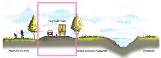
File:Waterretention diagram.jpg|Regrowing peatlands, hightening the groundwaterlevel. | File:Waterretention diagram.jpg|Regrowing peatlands, hightening the groundwaterlevel. | ||
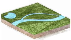
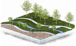
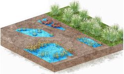
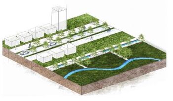
</gallery> | </gallery>The zone arround Moosach before it reaches Freising is the part of the landscape that needs to be revitalized in order to facilitate possible future extreme weather conditions and prevent floods from happening in the future. This is achieved by renaturalizing and remeandering the riverbed, thus creating space for the river to accumulate the flow of water when the extreme event happens. Once the riverbed is revitalized, trees are planted along it to help stabilize the riverbanks, protect the river from droughts, provide nutrients to the existing ecosystem, and create a dynamic and attractive natural environment. | ||
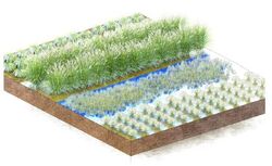
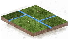
The area surrounding Freisinger Moos is devoted to paludiculture and peat regrowing. Ecological farming is also introduced in the area in order to help provide a wider range of ecosystem services like protecting the soil and increasing it’s fertility, limiting soil erosion and degradation, and helping conserve water and natural habbitats. Low maintenance food forests are also envisioned to develop along the riverbed in order to further promote biodiversity, increase the potential for variety of agricultural products, and create a more aesthetically pleasing environment. | |||
In order to facilitate the social connectivity needs a pedestrian route is envisioned to span along the entire meandering river and through the food forest and bike paths along the existing roadnetwork. | |||
==== Implementations for the city centre ==== | ==== Implementations for the city centre ==== | ||
| Line 316: | Line 326: | ||
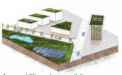
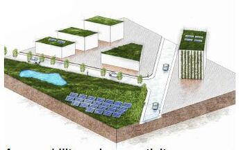
File:CO2 neutral city diagram.jpg|Creating a climate adaptive city with sunpanels, waterretention areas, more green, green roofs and facades. | File:CO2 neutral city diagram.jpg|Creating a climate adaptive city with sunpanels, waterretention areas, more green, green roofs and facades. | ||
File:Bridge diagram.jpg|Creating connections between the rivers Moosach and Isar. And connecting Freising more to the area of Lerchenfeld. By making tunnels and overpasses over the barriers, roads, railway and the Isar river. | File:Bridge diagram.jpg|Creating connections between the rivers Moosach and Isar. And connecting Freising more to the area of Lerchenfeld. By making tunnels and overpasses over the barriers, roads, railway and the Isar river. | ||
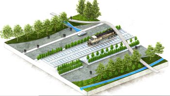
</gallery> | </gallery>The connectivity goal is achieved in several places in the city center. The microurban interventions – pedestrian and cycling overpasses are chosen as a solution to tackle this issue because of their affordability and effectivness. These overpasses are designed to connect the existing green areas of the city center with Isar. They transit the railroad and other physical barriers such as car parks and provide a more enjoyable environmet experience that the existing underground passages. The surfaces of the overpasses are covered by lush green spaces to further enhance the experience of the people who would use them. Ramps and elevators are incorporated in this design in order to facilitate all the social groups who could potentially use them. | ||
Besides the overpasses. Green corridors will add on to these connections. Creating a green artery that flows through the city. | |||
The entrance to the city is also changed (cross-section Vöttingerstraße, Hauptsraße, Wippenhauserstraße and Johannisstraße). Making it more accessible and safe for pedestrians and highlighting the route next to the Weihenstephanerberg, that connects to the countryside. | |||
=== Phases === | |||
The phases, shortly explain how the Green Renaissance scenario would come to pass. By taking steps of 10 years and shortly explaining the steps that would be taken within these 10 years to the completion of the Green Renaissance scenario. | |||
[[File:Phases for the Green Renaissance.jpg|none|thumb|1273x1273px]] | |||
== References == | == References == | ||
| Line 328: | Line 346: | ||
= Process Reflection = | = Process Reflection = | ||
Working with an international and interdisciplinary team was very interesting and usefull for us. We each have our own skills and specialities. We could learn from eachother and teach eachother new methods. The cultural and language barrier bring some difficulties, but these were easily worked trough because of the great atmosphere. We could each implement our own ideas and form a collective combined vision and design. We each had the opportunity to learn new things, such as using new programms, which we could then explain to eachother. By working together on location we improved our team work substantially, because its easier to discuss problems that arise in person. | |||
Revision as of 12:46, 18 July 2022
>>>back to working groups overview
Rationale
- Why do you think this case is relevant? What is your hypothesis considering the landscape challenges?
- Format: 3-4 sentences
Location and scope
You can edit this map with the map editor
Water as a natural system
Geomorphology, typologies and dynamics of water areas
Context
As a tributary of Isar and Amper, the river Moosach is part of the Danube river Basin. It's course runs in the north of Munich, in parallel with the suthern parts of tertiary sloping land and through a gravel plain which had paludified over time. As it runs through the gravel plain, it drains the large peatland areas ‘Freisinger Moos’ and ‘Dachauer Moos’, eventually transitioning through the unpaludified parts of the plain. The Moosach is characterized by the occurrence of several aquatic plants such as Juncus subnodulosus, Potamogeton coloratus, and Groenlandia densa, which clearly indicate that the Moosach is olygothropic and fed by calcareous-rich groundwater. (Poschlod, et al., 2010)
Water areas
Both river Isar and Moosach have changed a lot in the relatively recent times, thus they have a very artificial appearance. This is mostly due to human impact and exploitation of these two rivers as natural resources over the past centuries. The river Moosach in particular has several specific cathegories of appearance. From south to north the river morphs from a highly channeled water stream into the damp Freisenger Moos area. After that it's appearance transforms into a more natural one as it enters the city of Freising through the forest area beneath the Weihenstephan hill. From there on it splits into several very different branches which run through Freising. One part which had until recenly been completely ducted is now resurfacing through a large scale infrastructural intervention. The other branches are respectfully either surrounded by buildings or green areas. As these several parts exit Freising they reuinte into a single riverbed.
Flood plains
The river Moosach is a tributary to river Isar, but since the stream Mühlbach splits away from it carrying 30% of the water to river Apmer, Moosach can also be considered a tributary to Amper aswell. The foodplains of river Isar are contained by a natural buffer zone arround it, but due to the highly artificial waterway management of Moosach before and after it enters Freising and a lack of apropriate buffering from the urban tissue of the city, the region beneath the Weihenstephan hill is at risk of potential floods which could cause substanial damages. One of the recent examples has proven this risk can be substantial, as several streets in Freising were under water in the night of June 3, 2013, when the Schleifer-Moosach suddenly overflowed its banks. (Eser, 2021)
Risks and potentials
Water as a living space
Habitats
There are several important habitats in the project area which are closely tied to water bodies and need to stay protected, potentially expanded, and even connected. These habitats are: Ampertal habitat, Kammolch habitat, Heideflächen und Lohwälder habitat, Freisinger Moos habitat, and Isarauen habitat. The Isarauen habitat is the largest and best preserved habitat, as the natural buffer zone around river Isar provides the best conditions for preservation of uniform environmental conditions which the biotope essentially requires. However, the Freisinger Moos habitat is as biediverse as the Isiarauen, but due to systematic neglection of the area and overexploitation of the natural resources of river Moosach and the areas around it, the once large Freisinger Moos has shrunk to the area it now covers. Due to this fact many of the species that inhabit this biotope are endangered today and the Freisinger Moos became an important area of natural protection and preservation. (FORM, 2021)
Water quality
Essentially none of the water areas in the project area are natural, but some of them appear more natural and appealing. For example, the part of river Moosach between the Freisinger Moos and the foot of the Weihenstephan hill that runs in dull straight lines is less appealing than the part where Moosach enters Freising, where the spatial configurations and visual narratives of the river start becoming more dynamic and interesting.
Blue and Green Infrastructure
Blue and Green infrastructure
The difference between the BGI focus placement between the rivers Moosach and Isar is more than obvious. The BGI of the larger river Isar is established much better, as the natural buffer zone arround the river allows for a homogenous continuity of ecosystem services along the riverbed. On the other hand, the discontinuous zoning of river Moosach, along with a general disregard towards the rivers natural identity in the past, has led to a BGI which encapsulates the ecosystem services of the Freisenger Moos to a fraction of the area it once covered and endangers the existance of the weakest stakeholders of the ecosystem.
Water as a cultural space
Land use and water
Land-use
Most of the land-use in the plan area consists of agriculture. The second most form of land-use is grasslands. To the northwest of Freising there are forests and along the river Isar as well. The largest city is Freising. There are several smaller towns and villages, Eching, Neufahrn bei Freising, Mintraching, Märzling and Langenbach. Most of the commercial and industrial areas are located at the edges of the towns. The largest commercial area is at the town of Neufahrn. The München airport is another important economical area.
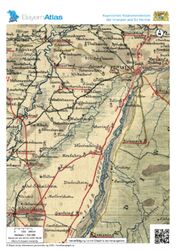
The 18th century map portrays that the majority of settlements were located on elevated grounds and along the Isar. Swampy areas of Moosach with a lower rate of water flow were not suitable for settlement. There were smaller mills built along this area. The road network is also more diverse on the higher grounds, while in the river plains it only connects settlements in the immediate vicinity of Isar. Freising's central role is revealed by the radiating road rings which. There are two types of settlements that can be observed: cities that preserved their medieval urban morphology and smaller villages with a population engaged in agriculture. Different types of landscapes, topography and hydrography determined the use of landscapes in the first place, so we can discover many similarities in today's landscape use. However, on this map it is important to point out that the intermittently flooded areas of the Moosach were much larger in the past, and that it is worth observing the lineage of the small water bodies.
With the construction of the Munich-Landsut railway line in the 1900s, the settlements between Isar and Moosach began to develop. The secondary road network became more diverse as well. Draining areas along smaller watercourses allowed new arable land to emerge. The railway also boosted trade: the production of sand and gravel on the gravel plains started booming.
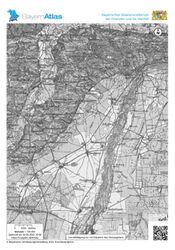
In the 1980s, Freising exploded, its urban tissue owerflew the medieval core of the city and extended south of Isar. The construction of the A92 high-traffic road had also provided a connection to the NSW. The growth of the main road network and the increase in car traffic facilitated the territorial expansion of smaller settlements. At this point Freising had already long been the satellite city of Munich. Eching and Neufahrn merged into the agglomeration of Munich as the transport improved and the population of Munich grew. The smaller water streams, including the Moosach River, were at this point transformed almost completely along their entire riverbeds, making the rivers lose their natural shape. The landscape became dotted with smaller lakes, which were created by groundwater rising in the pits of abandoned gravel mines.
By the year 2008, the airport was built south of Freising. This meant not only new job opportunities, but it also further strengthened the relationship between Freising and Munich. In the next 30 years, the settlements between Munich and Freising are bound to continue growing.
Cultural and spatial typologies of water areas
Spatial patterns
In the historical cultural context, the rivers were one of the most important aspects for existance, mobility, transport of resources, and trading. Due to this reason all human settlements of the inlands tend to be close or directly next to streaming water bodies. In the context of contemporary cultural landscape of Freising, the rivers upon which the city evolved play a major role for preservation of culture. This implies that the society in Freising has a strong tendency to restore the river Moosach to it's natural state to the extent that is possible. Moosach has various spatial patterns along the course of its stream, patterns which have shaped the urban morphology of the rural and urban areas, as well as the cultural landscape of Freising. Even though Moosach is severely altered due to human needs, it still represents the main artery of the cultural bloodflow in the city, since some of the most beutiful places in Freising, both natural and artificial in terms of visual appearance, are directly tied to the river branches.
Sacred spaces and heritage
Sacred places
The history of Freising County has been organically linked to religion since the early centuries. The central role of religion in Freising is associated with Corbinian Bishop. These spiritual tendencies in the life of the city left many landmarks, which even nowdays have a high quality for identity-forming of the locals. The smaller landmarks, like the roadside crosses, are important as well, because they were in most cases set up by the inhabitants of the villages and they portray the trail of the former road network. They are also helpful for orientation.
The two sacral spaces which hold cultural value for the locals, especially for the catholic religious community, are the Freising Cathedral located on the Domberg and the former Corbinian chapel located on the Weihenstephanerberg. The Freising Cathedral holds value since it is still being used as one the important spaces for everyday prayer in Freising, and the Corbinian chapel is important because it serves as a memorial preserving the memory of a centuries-old local legend which shapes the identity of Freising to this day. Other than the important sacral heritage, Freising cherrishes it's brewing tradition, as the worlds oldest brewewry located on Weihenstephanerberg operates to this day.
Visual appearance and landscape narrative
Visual appearance
The essential elements of the large scale visual landscape character are the important spatial determinants (old core of the city, the two hills, the water bodies, etc.) , traditional local practices (gardening, brewing, etc.), and the increasing awareness of the importance of ecology (riverbed restoration plans and projects already in implementation). Freising had beeen depicted in many historical paintings. The most notable one in the context of Freising landscape representation is probably the aerial view painting from a series depicting possessions of the Freising Bishopric in the princely corridor between the prince-bishop's residence and Freising Cathedral painted by Valentin Gappnigg in the late 17th and early 18th century. This painting in particular is very important because it represents well the different landscape typologies, from the Freisinger Moos and Moosach, over the Isar in the distance, the gardens on Weihenstephan, the farmlands left of weihenstephan and the urban tissue od Freising. The many different narratives of the specific project area that exist today have been extensively written about by many researchers from different fields, from the context of geomorphology and water quality (Poschlod, et al., 2010), over the context of flood risk governance (Snel, et al., 2022), to the risk for biodiversity and endangerment of native species caused by other invasive species in the river (Wutz & Geist, 2013), etc. The main new narrative that is emerging in the visual context is the restoration of river Moosach. (Schnetz, 2020)
- The Weihenstephanerberg can be seen from almost everywhere within the plan area.
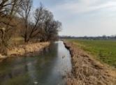
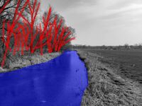
- The Moosach flows through wide open fields. Formed by the grasslands and agricultural lands. With tree rows as barriers.
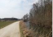
- The Moosach flows next too forests. These forests are located by the Weihenstephanerberg and in between Freising and Märzling. On one side of the Moosach there are forests and on the other side open fields.
- Within Freising there are several parks situated along the Moosach. The trees and shrubs here often prevent people from being able to even see the Moosach.
- When the Moosach enters Freising it splits in to multiple streams. Just before it exits Freising they all come back together.
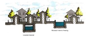
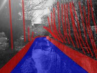
- Within Freising the Moosach flows through a concrete ''container''.
- Within Freising the Moosach often has to go under buildings and for some parts it is even completely covered up.
- Within Freising the Moosach is very canalized and consists of mostly straight lines.
- The Moosach flows next to the lower Bavarian hills. It flows next to these hills at the Weihenstephanerberg and in between Freising and Märzling.
Water and People
Accessibility and usability
Most parts of the riverbed of the Moosach branches within the urban tissue of Freising are accessible in terms of visusal connectivity, but not so many parts of the river within the city can be directly phisycally accesed due to the artificial embankment of the riverbed. Those areas than can be phisically acessed in the city have high functional and aesthetical values. As we exit the urban area of freising and go further up the stream towards the Freisinger Moos area, the riverbed becomes becomes more natural in terms of it's green surroundings, but the pedestrian and cycling mobility infrastructures along the riverbed soon dissappear and direct phisycal accessibility is harder to achieve.
Community Mapping
Social groups
The dominant social groups which use the river Moosach for recreation purposes such as strolling, biking, swimming, and playing next to it are families with children, the students, the elderly, the disabled, etc. Each of these group has specific needs in terms of safety, accesibility, and usage of the river. For example, chiledren playgrounds need to be properly distanced and separated from the water, otherwise good visual communication between the playgrounds and the water must be established so that the kids parents or caretakers can properly survey them. The elderly and the retired need to have appropriate acces points to the riverbed, like ramps and staircases with gentle slopes, as well as places where they can rest while stroling along the riverbed. The students and some other social groups like to swim in the river from time to time, and appropriate swimming areas need to be mapped out and defined accordingly.
The local stakeholders such as the ecologists, NGOs, and farmers may have conflicting interests, in the terms that the plans for Moosach riverbed restoration might cause power conflicts between these stakeholders if the needs of the farmers are not met in the new river restoration designs.
The external stakeholders such as the Green Party have large external influence on wether the plan to adapt the river to mittigate the climate changes, reduce the risks of flooding, and promote the cultural connectivity and accessibility to the river.
Local stakeholders
The local stakeholders such as the ecologists, NGOs, and farmers may have conflicting interests, in the terms that the plans for Moosach riverbed restoration might cause power conflicts between these stakeholders if the needs of the farmers are not met in the new river restoration designs.
External stakeholders
The external stakeholders such as the Green Party have large external influence on wether the plan to adapt the river to mittigate the climate changes, reduce the risks of flooding, and promote the cultural connectivity and accessibility to the river.
Needs, objectives, power and capacities
Power conflicts
Possible Futures
SWOT analysis
DPSIR
Scenarios
Vertical axis
The urbanization axis is divided into urban sprawl on one side and
compact city on the other. With an expected population growth of 28%.
This implies that scenarios which are on the unsustainable side of
the axis will not apply the sustainable methods of urban development
(regenerative urban development, retrofitting, etc.) in the future.
Horizontal axis
The Climate change adaptation and prevention axis predicts that two of
the scenarios will attempt to adapt to climate change, and even prevent
further climate change through radical reduction in CO2 emissions.
Worst case scenario
The parasite cities represent the worst case scenario for symbiosis between man and nature in the project area. In this scenario there is no climate adaptation and mitigation, and no adaptation of urbanisation to the sustainable development goals. Lack of adaptation of urbanization leads to sprawling urban and suburban tissue, which will have substantial impact on the quantity and quality of natural spaces within and outside the cities boundaries. In addition to this, lack of climate adaptation and mitigation could lead to potential cathastrophic flooding and drought events, but also to the preservation of current ways of farming, which might have a larger impact on the further endagerment and even dissappearance of the Freisinger Moos habitat.
Not bad or good scenario's
The wild west and urban sprawl both lack implementation of proper means of either climate change adaptation or urbanization developments. The wild west implies that unless climate change issues are tackled promptly and appropriately, the consequences might impact the entire area even though good urbanization practices are implemetned. This would be reflected in severe droughts, destruction of natue, fall of economy, etc. On the other hand, urban sprawl predicts that even though climate change is taackled now and in the future, poorly regulated urban developments might cause other issues such as reducing walkability and social interactions and isolating people.
Best case scenario
The best case scenario, the Green Rennaissance, is depicted as a mutualism symbiosis between man and nature. In this scenario the sustainable goals of development are met through climate change adaptation and mittigation, as well as through good urbanisation practices. Regenerative urbanisation methods such as dense, compact, tactical, and diverse development will solve the problem of population growth without impacting the natural context. Use of sustainable landscape, urbanist, and architectural methods and interventions will lead to reduction of heat islands within the newly developed urban quarters and and an increase of the residential area livability. Climate adaptation and mittigation measures will successfully reduce the risks of floodings and droughts. The flood retention areas are designed in such a manner that the newly introduced noninvasive plant species and landscape interventions do not damage the nature and agriculture. The new forms of agriculture, like paludiculture are implemented in the rural areas, while vertical farming is implemented in the urban areas. In addition to this, due to the new farming methods, the Freisinger Moos habitat will be successfully presrerved and will have more potential for regrowth in the distant future.
Visualizations
Green Renaissance
Parasite Cities
Suburbia
Wild West
Collaborative Goal Setting
- Creating more physical and visual connections betwee nthe rivers Moosach and Isar
This point has been forgotten by the city of Freising. These connections are currently lacking within the area. The main road and the railway both function as a barrier within the area. Without prior knowledge people will not know how to get from one river to the other, whilst in the city of Freising. We want to improve this with more signage, creating green corridors and creating more connecting paths (including bridges and tunnels).
- Improving the active mobility network
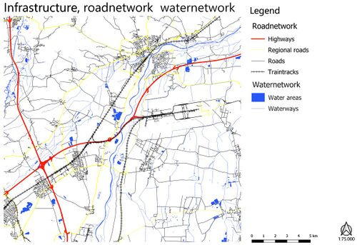
The active mobility network within the plan area is lacking. There is a lack of walking paths next to the river Moosach, once you leave the city of Freising. There is also a lack of infrastructure for bycicles, where you mostly need to ride on the same road as the cars. We want to improve this by adding walking paths next to the Moosach river and creating bike lanes next to the existing roadnetwork.
- Climate adaptive city of Freising in 2050
It is an overall important factor to create a climate adaptive city. To prevent the Urban Heat Island effect. To make sure that Freising does not experience more floods. To make sure Freising can, to a degree, produce its own energy. We want to improve this by adding more green within the city, replacing concrete with green. By adding green roofs and facades. By adding waterretention areas within the city. By adding sunpanels on top of roofs and by creating new housing in a sustainable way.
- Creating local hubs
We want to improve the smaller surrounding villages. By offering the surrounding villages more amenities. This takes some pressure of the city of Freising and promotes the smaller towns.
- Improving the waterinfrastructure
The local waterinfrastructure has changed a lot throughout the years. The river Moosach has been canalized and floodings have become more frequent. The Isar is an outlier within this, having a good existing infrastructure. We want to improve this by remeandering the river Moosach, hightening the groundwaterlevel, regrowing peatlands, creating more floodarea's upstream to prevent floodings in the city and connecting the rivers Moosach and Isar with eachother through green corridors.
- Offering new revenue models
The agriculture in the area has caused the peatlands to slowly disappear. By needing to lower the groundwaterlevel for cropgrowing and kettle herding. We want to offer the farmers new revenue models. That can be even more profitable than the current ones. These revenue models will focus on ecological agriculture and paludiculture. These models will prevent nature from being destroyed.
- Protecting the Freisinger Moos area
The Freisinger Moos area is a small peatland area. It used to be a lot larger. It contains several special flora and fauna species. It is important to protect this natural area. We want to do this by offering the area more space to grow back. Hightening the groundwaterlevel so that peat can slowly regrow. Making the space around the river Moosach a natural zone.
Spatial Strategy and Transect
Vision
In 2050 the Freising area will be a new green zone. Where the biotopes and natural areas form a connected green corridor. Sustainable housing will give place to a multitude of people, that can live together in new and improved communities. Where living, leisure and work can be found in one combined uses zone. The city of Freising will no longer be disconnected by the large barrriers of the roads, railroads and even the Isar river. Agriculture will have changed to a more ecological and sustainable way with ecological agriculture and paludiculture. The small towns and villages surrounding Freising will have kept their local identities and will be great locations to live, work and recreate. This creates a large connected ecological system, which forms the backbone of the landscape.
3 transects
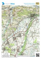
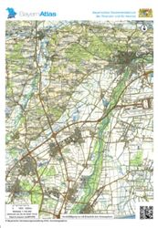
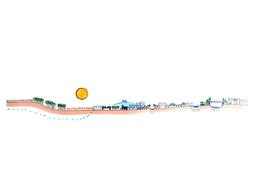
We have chosen 3 transect areas. The areas are situated to far away from eachother to be shown on a single map. Because of that we have chosen to focus on 3 seperate areas. To show the implementations we would like to use and to show how we would like to work on our goals within these areas.
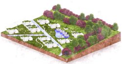
Transect area, showing implementations for new housing.
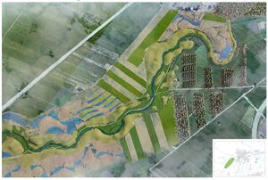
Transect area, showing implementations for nature and agriculture.
Transect area, showing implementations for the city centre.
From Theory of Change to Implementation
Implementations for new housing areas
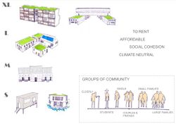
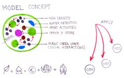
The new housing developments in Freising should implement commendable practices which sattisfy the UN sustainable development goals and enrich the residential area livability capacity.
The locations of these developments were chosen according to the existing regulation plans.
All the neccessary factors that indicate a high level of livability, from social interaction engagement, through introduction and preservation of natural, cultural, leisure, and recreational content.
Besides this, the urban and architectural composition of these urban quarters should be dynamic in terms of compositional and aesthetic principles, varying building typologies, and the hierarchy of open spaces between them.
Implementations for agricultural and natural areas
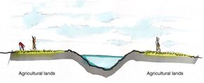
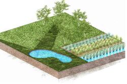
The zone arround Moosach before it reaches Freising is the part of the landscape that needs to be revitalized in order to facilitate possible future extreme weather conditions and prevent floods from happening in the future. This is achieved by renaturalizing and remeandering the riverbed, thus creating space for the river to accumulate the flow of water when the extreme event happens. Once the riverbed is revitalized, trees are planted along it to help stabilize the riverbanks, protect the river from droughts, provide nutrients to the existing ecosystem, and create a dynamic and attractive natural environment.
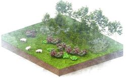
The area surrounding Freisinger Moos is devoted to paludiculture and peat regrowing. Ecological farming is also introduced in the area in order to help provide a wider range of ecosystem services like protecting the soil and increasing it’s fertility, limiting soil erosion and degradation, and helping conserve water and natural habbitats. Low maintenance food forests are also envisioned to develop along the riverbed in order to further promote biodiversity, increase the potential for variety of agricultural products, and create a more aesthetically pleasing environment.
In order to facilitate the social connectivity needs a pedestrian route is envisioned to span along the entire meandering river and through the food forest and bike paths along the existing roadnetwork.
Implementations for the city centre
The connectivity goal is achieved in several places in the city center. The microurban interventions – pedestrian and cycling overpasses are chosen as a solution to tackle this issue because of their affordability and effectivness. These overpasses are designed to connect the existing green areas of the city center with Isar. They transit the railroad and other physical barriers such as car parks and provide a more enjoyable environmet experience that the existing underground passages. The surfaces of the overpasses are covered by lush green spaces to further enhance the experience of the people who would use them. Ramps and elevators are incorporated in this design in order to facilitate all the social groups who could potentially use them.
Besides the overpasses. Green corridors will add on to these connections. Creating a green artery that flows through the city.
The entrance to the city is also changed (cross-section Vöttingerstraße, Hauptsraße, Wippenhauserstraße and Johannisstraße). Making it more accessible and safe for pedestrians and highlighting the route next to the Weihenstephanerberg, that connects to the countryside.
Phases
The phases, shortly explain how the Green Renaissance scenario would come to pass. By taking steps of 10 years and shortly explaining the steps that would be taken within these 10 years to the completion of the Green Renaissance scenario.
References
- Eser, M., 2021. merkur.de. [Online]. Available at: https://www.merkur.de/lokales/freising/freising-ort28692/freising-starkregen-welche-regionen-im-landkreis-gefaehrdet-sind-90893333.html. [Accessed 20 May 2022].
- FORM, N. 2. -. S. D., 2021. Kammmolch-Habitate im Kranzberger Forst. [Online]. Available at: https://natura2000.eea.europa.eu/Natura2000/SDF.aspx?site=DE7535371. [Accessed 20 May 2022].
- Poschlod, P. et al., 2010. Long-Term Monitoring in Rivers of South Germany Since the 1970s – Macrophytes as Indicators for the Assessment of Water Quality and Its Implications for the Conservation of Rivers. In: Long-Term Ecological Research. London: Springer Dordrecht, pp. 189-199.
- Schnetz, W., 2020. merkur.de. [Online] Available at: https://www.merkur.de/lokales/freising/freising-ort28692/innenstadtsanierung-in-freising-wurde-moosach-geoeffnet-13803087.html [Accessed 20 May 2022].
- Snel, A. K. et al., 2022. Unpacking notions of residents' responsibility. Environmental Policy and Governance, Issue Special issue article, pp. 1-15.
- Wutz, S. & Geist, J., 2013. Sex- and size-specific migration patterns and habitat preferences of invasive signal crayfish (Pacifastacus leniusculus Dana). Limnologica, 43(2), pp. 59-66.
Process Reflection
Working with an international and interdisciplinary team was very interesting and usefull for us. We each have our own skills and specialities. We could learn from eachother and teach eachother new methods. The cultural and language barrier bring some difficulties, but these were easily worked trough because of the great atmosphere. We could each implement our own ideas and form a collective combined vision and design. We each had the opportunity to learn new things, such as using new programms, which we could then explain to eachother. By working together on location we improved our team work substantially, because its easier to discuss problems that arise in person.


