Uncategorized files
Jump to navigation
Jump to search
Showing below up to 50 results in range #101 to #150.
-
 1637-3.jpg 711 × 485; 162 KB
-
 1769 Dimitrie Cantemir, Descriptio Moldaviae.jpg 1,342 × 2,272; 1.41 MB
-
 17parte.jpg 1,536 × 1,536; 129 KB
-
 1913.jpg 737 × 483; 140 KB
-
 1920px-Lacul Plumbuita și Lacul Tei bgiu.jpg 1,920 × 1,110; 453 KB
-
 1930.jpg 777 × 479; 90 KB
-
 1 Joe Paadisadam Port copie.jpg 1,968 × 1,314; 372 KB
-
 1 Turusadam Port.jpg 1,954 × 1,462; 378 KB
-
 1est.jpg 369 × 769; 61 KB
-
 1map.JPG 897 × 623; 102 KB
-
 1responses.JPG 1,847 × 840; 186 KB
-
 2-2.jpg 936 × 698; 195 KB
-
 2-Neubrandenburg Green and blue infrastructure.jpg 2,442 × 1,641; 1.8 MB
-
 2.1.PNG 440 × 602; 528 KB
-
 2.10 Situation on the area around 1940 BayernAtlas.png 602 × 380; 233 KB
-
-
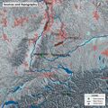
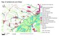 2.12 Map settlements and water.jpg 505 × 356; 55 KB
-
 2.13 Map Denkmäler.PNG 1,196 × 845; 1.82 MB
-
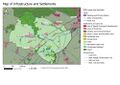 2.2 Infrastructure and settlements.jpg 499 × 353; 48 KB
-
 2.3 Map of the area in 1857.png 529 × 340; 352 KB
-
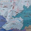
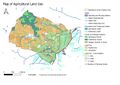 2.4 Map of agricultural land use.jpg 1,216 × 859; 178 KB
-
 2.6 Freisinger moos- recreation area.jpg 143 × 190; 12 KB
-
 2.7 Touristic use of the moos.PNG 1,063 × 466; 796 KB
-
-
 2.9 Situation on the area around 1890 BayernAtlas.png 602 × 421; 256 KB
-
 2. Cultural and spatial typologies of water areas.png 1,320 × 815; 1.94 MB
-
 2. Needs and Interests of Stakeholders.jpg 2,480 × 1,754; 219 KB
-
 2.jpg 395 × 773; 77 KB
-
 2050.jpg 4,060 × 2,250; 514 KB
-
 210422 Neckar Structure.jpg 1,280 × 720; 148 KB
-
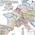
 210422 Neckar of Europe.jpg 1,573 × 1,573; 1.48 MB
-
 210422 maps 01.jpg 978 × 978; 1.38 MB
-
 210422 maps 02.jpg 978 × 978; 1.37 MB
-
 210422 maps 03.jpg 978 × 978; 1.11 MB
-
 210422 maps 04.jpg 978 × 978; 1.47 MB
-
 210422 maps 05.jpg 1,291 × 1,291; 1.24 MB
-
 210422 maps 06.jpg 1,291 × 1,291; 1.25 MB
-
 210422 maps 07.jpg 1,291 × 1,291; 1.25 MB
-
 210422 maps 08.jpg 1,291 × 1,291; 1.22 MB
-
 210422 maps 09.jpg 1,291 × 1,291; 1.05 MB
-
 210422 maps 10.jpg 1,291 × 1,291; 1,016 KB
-
 210422 maps 11.jpg 1,291 × 1,291; 1.09 MB
-
 210422 maps 12.jpg 1,291 × 1,291; 1.22 MB
-
 210422 maps 13.jpg 1,291 × 1,291; 1.23 MB
-
 210422 maps 14.jpg 1,291 × 1,291; 1.22 MB
-
 210422 maps 15.jpg 1,291 × 1,291; 1.21 MB
-
 210422 maps 16.jpg 1,291 × 1,291; 1.14 MB
-
 210422 maps 17.jpg 1,291 × 1,291; 1.16 MB
-
 210422 maps 18.jpg 1,291 × 1,291; 1.12 MB
-
 2158797021 46d28792bf.jpg 500 × 341; 83 KB


