Uncategorized files
Jump to navigation
Jump to search
Showing below up to 50 results in range #1,101 to #1,150.
-
 Neckar people river.JPG 1,200 × 802; 1.14 MB
-
 Neckar river as Historical Culture Map 10000.png 2,222 × 1,236; 1.39 MB
-
 Neckar riverside path.jpg 768 × 1,024; 187 KB
-
 Neckar riverside path2.jpg 1,024 × 768; 177 KB
-
 Neckarhousen dike.jpg 689 × 919; 599 KB
-
 Neckarisland spatial your governance model.jpg 1,280 × 720; 81 KB
-
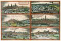
 Neubrandenburg 1820.jpg 440 × 541; 98 KB
-
 Neubrandenburg 1953.png 2,794 × 1,458; 1.68 MB
-
 Neubrandenburg 1991.png 2,792 × 1,450; 1.66 MB
-
 Neubrandenburg Areas for Blue and Green Infraestructure.jpg 1,024 × 1,024; 129 KB
-
 Neubrandenburg Broda.jpg 800 × 600; 121 KB
-
 Neubrandenburg Green, blue and gray infrastructure.jpg 1,230 × 788; 1.04 MB
-
 Neubrandenburg Green and blue infrastructure..png 1,173 × 789; 1.34 MB
-
 Neubrandenburg Green and blue infrastructure.JPG 1,203 × 784; 123 KB
-
 Neubrandenburg connections of Green and Blue Infrastructure.jpg 3,424 × 2,331; 549 KB
-
 New constructions.jpg 3,024 × 4,032; 1.81 MB
-
 New field of wild plants eco scenario.jpg 3,787 × 2,840; 691 KB
-
 New pathways diagram.jpg 359 × 219; 24 KB
-
 Next to farmland photo.jpg 172 × 121; 11 KB
-
 Next to forest-hill photo.jpg 166 × 122; 12 KB
-
 Next to gardens photo.jpg 162 × 124; 12 KB
-
 No2 belastung.jpg 1,698 × 1,226; 461 KB
-
 No Participation into the environment.png 1,024 × 768; 396 KB
-
 Nordmünchner Kanalsystem.png 603 × 599; 174 KB
-
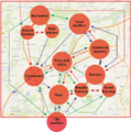
 Nr. 1 Stakeholders whole landscape.png 1,097 × 777; 589 KB
-
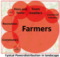 Nr. 2 Fysical power.png 883 × 835; 794 KB
-
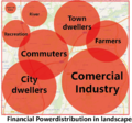 Nr. 3 Financial power.png 887 × 830; 833 KB
-
 Nr. 4-Interests and needs of stakeholders.JPG 2,559 × 1,593; 281 KB
-
 Nr. 5 Power distribution in landscape.png 828 × 838; 1.02 MB
-
 Nucleo.jpg 4,254 × 1,777; 501 KB
-
 Nuertingen WAVE Team 3.jpg 505 × 565; 76 KB
-
 Nuertingen WAVE Team 4.jpg 960 × 1,280; 446 KB
-
 Nuertingen WAVE Team 5.jpg 1,183 × 884; 277 KB
-
 Nuertingen hlab header.jpg 1,200 × 800; 1.06 MB
-
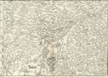
 Nürtingen, Andreas Kieser.png 891 × 254; 562 KB
-
 O2 temp.png 1,684 × 1,256; 140 KB
-
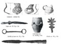 Objects found in Tei Lake Archaeological Site.PNG 717 × 548; 194 KB
-
 Objects found in Tei Toboc Archaeological Site.PNG 730 × 427; 411 KB
-
 Old map.png 877 × 629; 1.22 MB
-
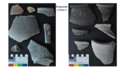
 Old pictures 1.jpg 1,228 × 818; 305 KB
-
 Old pictures 2.jpg 1,092 × 781; 218 KB
-
 Old pictures 3.jpg 1,212 × 504; 115 KB
-
 Oooooooo.jpg 215 × 286; 21 KB
-
 Open area analysis photo.jpg 1,170 × 872; 136 KB
-
 Our Goals.jpg 3,796 × 2,250; 348 KB
-
 Our vision.jpg 3,796 × 2,250; 468 KB
-
 Our vision of river renaturalization.jpg 4,001 × 2,250; 818 KB
-
 Overview.jpg 1,271 × 765; 88 KB
-
 OvidiuIsland.jpeg 1,117 × 728; 194 KB
-
 OvidiusParkSiutghiol1.jpeg 1,200 × 1,600; 332 KB


