Tartu Upstream WAVE Living Lab 2021
>>>back to working groups overview
Rationale
- Why do you think this case is relevant? What is your hypothesis considering the landscape challenges?
- Format: 3-4 sentences
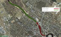
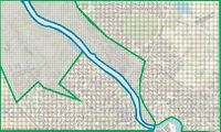
Location and scope
You can edit this map with the map editor
Water as a natural system
Geomorphology, typologies and dynamics of water areas
-Emajõgi is a 100 km long river that flows from Lake Võrtsjärv located in southern Estonia, through Tartu County into Lake Peipsi located on the east border. 10 km of it goes through the city of Tartu. -Emajõgi river is divided into 3 sections:
  1) Upper course from Võrtsjärv to Kärevere bridge which is characterized by large, flat, and marshy areas and heavy meanders which are a part of Alam-Pedja Nature Reserve. The floodplain there doesn't have a defined floodplain, as the water can span several kilometers.
  2) Middle course from Kärevere to Kavastu through Tartu river has a straighter course and floodplain can be defined, the valley is mostly shallow which maximum depth of 10 m and width of 1-1,5 km (in Tartu it's narrowed to 800 m)
  3) Lower course of the river flows through Emajõe Suursoo characterized by swampy lowlands and is entering Lake Peipsi at Praaga.
Half of the water feature in our living lab is artificial (canalized) river and the other half is natural with outdoor activities such as beaches & man-made wetlands. There is a small riverside bulwark located by the side of the river. Bodies of surface water are divided into watercourses (rivers, brooks and ditches) and stagnant water (lakes, ponds).
Main floodplains and catchment areas are located outside of the city center on the western side of the living lab. Floodplain is heavily canalized and is covered by trees, which helps with the water redistribution. It allowed the city to regulate the river in the center and protect the city from flooding.
Water in Emajõgi river fluctuates between 1,2-2,6 m in a year and during summer it can cause floods. In the most extreme situations the water rises till 3,75 m. Emajõgi River rises its level after winter. Because of it Tartu struggles with the water level often. When Emajõgi in Tartu rises 2,54 m above the station schedule zero is critering as a high inland water lever alter. Water level exceeded by 0,5-1 m happens every ten years and more than 1m happens every 50 years. The drop from Võrtsjärv to Peipsi is little so it sometimes results of change of the waterflow in the river during winter when the surface runoff in the eastern area is bigger. The reverse flow is slow, 7 cm/s.
Most of the living lab adjacents with natural areas and buildings are remoted from the river. Residential areas on the southern side of the living lab are endangered by the water fluctuation during extreme events. Even without heavy snow it’s not possible to use passages under the Kroonuaia bridge. This event occurred in 2020, 2010, 2008 and 1999. In may 1867 record flood in Tartu took place. In 2019 Crisis Commitee discussed the flood risk during spring. and from november that year special staff training took place that would provide better water and sewager services
- add 2-3 graphical representations to the image gallery, you can add more if you like
Water as a living space
- Which habitats can be found in and along the water areas of your area?
- How is the water quality in your water areas?
- Which areas are still natural, which are urbanised/artificial?
- Are the rivers permeable for fish or blocked by artificial elements?(approx 200 signs)
- add 1-2 graphical representations to the image gallery, you can add more if you like
- Yourcase wateraslivingspace2.jpg
add a caption
- Yourcase wateraslivingspace3.jpg
add a caption
Blue and Green Infrastructure
- What are the major potential elements of a green/blue infrastructure network? Are these likely to change/disappear? Why is that?
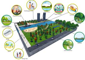
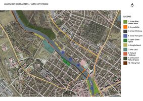
In the past the area was covered with residential buildings, but as an effect of WWII the area got demolished. As result of it there are plans to change it from grey structure to green structure and some blue structure to prevent it from flooding.
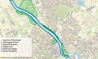
Green/Blue structure
Supilinna Tiik wetland
This is a man-made wetland on the western bank of the river and it’s made for preventing flooding into the city of Tartu
Püsietupaik Forest
It’s a natural protected untouchable mixed forest with only some hiking trails is located on the eastern bank of the river. Endangered species are also protected in protected areas and conservation areas, but in addition to the species protection objectives, there are also wider objectives - protecting endangered communities, preserving, protecting, restoring, researching or introducing nature. As a rule, the area of protected areas and conservation areas is larger than in permanent habitats.
Roositiik beaches
The beach is located on the western bank of the Emajõgi River, there is a sandy beach for sunbathing. There are various attractions for children: swings, climbing equipment, a slide and, a basketball basket. During the summer months, the Coast Guard also works during the day.
Ülejõe Park
This park was made after WWII as a green buffer from the urbanized part of Tartu city which has a lot of memorial monuments such as Hugo Treffner, Friedebert Tuglas, a sculpture group to celebrate the birth of the 100,000th Tartu resident, and memorial stone in honor of the first Estonian general song festival
Botanical Garden of the University of Tartu
The botanical garden is located on the western bank of the river, the area for growing monocots was re-designed into a free-shaped one at the beginning of the 1990s. The most rich-in-species groupings comprise the family Liliaceae (genera Tulipa, Allium, Fritillaria, Ornithogalum), the Iris family, the Orchid family, families Gramineae, Cyperaceae, Araceae.
Ranna Tee Buffer
It’s a buffer of Pine trees which is located in the eastern part of the Emajõgi River. It has some recreational activities such as musical concerts, canoeing launching areas.
- add 1-2 graphical representations to the image gallery, you can add more if you like
Water as a cultural space
Land use and water
- map the land uses along your water areas: settlements, infrastructure, agriculture, resource extraction, natural areas, energy production...
- describe in particular the historical evolution of land use pattern, please make use of historical maps
- description evolution, status quo and driving forces, is the land use likely to change? Why is that? (approx 200 signs)
- add 1-2 graphical representations to the image gallery, you can add more if you like
- Yourcase landuse1.jpg
add a caption
- Yourcase landuse2.jpg
add a caption
- Yourcase landuse3.jpg
add a caption
Cultural and spatial typologies of water areas
- Which spatial patterns have evolved in relation to your water areas?
- What is the role of water areas within the overall urban morphology? (approx 200 signs)
- add 1-2 graphical representations to the image gallery, you can add more if you like
- Yourcase water space1.jpg
add a caption
- Yourcase water space2.jpg
add a caption
- Yourcase water space3.jpg
add a caption
Sacred spaces and heritage
- Which places/elements hold cultural value and to whom?
- You may add a map and some images, please also explain in your caption why these elements are valuable
- Your case sacredspace1.jpg
add a caption
- Your case sacredspace2.jpg
add a caption
- Your case sacredspace3.jpg
add a caption
Visual appearance and landscape narrative
- Which elements are essential for the landscape character?
The most important motive for the city are people surround the river, as this space heavily used by people becouse of its values. They are created by the multiple pathways by the riveres, bridges, parks, platfmorms, river boulevards, man-made beaches, old Tartu Pool area which is now a renewed recreational space and hiking trails. River is quite simmetric
- Has the landscape been painted or otherwise depicted, when and whom? Which elements are essential?
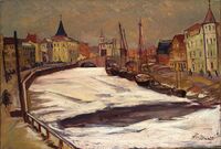
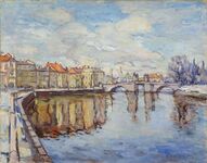
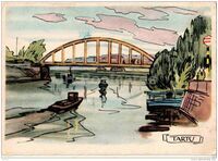
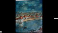
Landscape of Emajogi river has been painted mostly by Estonian arists. There has been a few motives that represents urban part of the river, nature surrounding it and mostly they comemorate Stone Bridge of Tartu which has been destroyed in 1941. The most famous representation of this bridge is created by Villem Ormisson named "Tartu vaade" which translates to "View of Tartu" painted in 1937. It is presenting how winter looked like in the city center and captures how light is moving through out buildings and the river which is characteristic for impressionism paintings.You can notice there how image of the citi has change from more of the urban approach with buildings on the side of the river and more of a man-made landscape. Tartu swimming pool is captured on Varmo Pirk's painting named 'Tartu Ujula' created in 1940r. There is also series of postcards painted by A. Kütt who captured the mosti iconic part of the city. They present everyday life in Tartu surrounded by the most iconic landmarks of the city. River and the bridges accompanied by fisherman and boats are a common motive on those proving the importance of the river space for the city.
- Which narratives exist? Who has written about this landscape or depicted it in some way?
Narration about the river presents the life that is happening in its surrounding. Showing the river as a conector of the people and how much their life is connected to Emajogi - how it flows with all the actions happening around her. Idea like this is presented in a poem Tartu 'When It Sizzle' by Remo Gramigna.
</gallery>
Water and People
Accessibility and usability
- Where are your water areas accessible, and where not? How strong are spatial obstacles preventing access?
- Who is using the spaces and how?
Most of the Emajõgi River is accessible for people and it’s not accessible only in the parts of the natural protected area. Most of the access points are mainly pedestrian-only and very limited for the vehicle parts. On both banks of the river, the access points are the fishing places across the urbanized part of Tartu city with no vehicle access. On the western bank, the access points are the Roositiik beaches with no automobile access and some activities are available within water like ice bathing, swimming, etc. the western bank the Supilinna Tiik wetland which is a man-made wetland is not accessible for people there is a hiking trail along the river bank. On the eastern bank most of it accessible for a pedestrian on the Ranna Tee Street which it’s accessible for pedestrian for a walk and some activities such as musical concert and canoeing launching. The only place which is not accessible for water is the Püsietupaik Forest as it’s a natural protected area and there is a pine trees barrier the prevents any connection to the water feature. Most of the users of the Emajõgi River are local fishermen, families with kids for the beach area, young people, and especially university students.
Community Mapping
What is to be mapped here? Community mapping for the upstream part of the Emajõgi River has gone through a lot of history after World War II. The Soviet-era produced a Russian community in Estonia alongside the Estonian community which has a result of mixed culture. Tartu is considered a student city as there are two big universities (Tartu University and Estonian University of life sciences) which produced a huge student community in the city, not for the Estonians/Russians but for international students as well. The upstream of the Emajõgi River is well-known for the restaurant and cafes that are located at the city center which is near the western bank of the river. Which results in a local mixed community.
Social Groups
Families which most probably prefer places where they can enjoy their time with their kids in friendly places where they can do some activities.
Kids where they can do some scholar activities and some playgrounds.
Teenagers tend to go to places where it’s private and with some outdoor activities.
University students prefer to have spaces with activities within river banks.
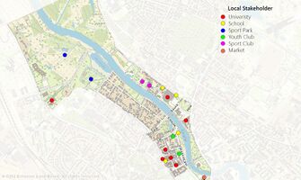
Local stakeholder groups
University which is most of them are accessed to the river as University of Tartu Art Museum or it’s located on the water as University of Tartu Faculty of Economics and Business Administration.
Schools The schools use the green/blue structure for education and for activities such as field trips and they are located near the Emajõgi River
Sports Park which is a main outdoor recreational activity place for families and teenagers and even the university student
Youth club which is mainly for the canoeing club which is located on the eastern bank of the Emajõgi River
Market Tartu Market Hall is the main local market in Tartu which is located near to Riia bridge which is the main bridge in Tartu
- External stakeholder groups are not necessarily present in the environment you are observing, but they may have strong stakes and interests. These can be local authorities, politicians, associations, care services etc.
- For each group, you may identify their needs, objectives, power and capacities
- You may also identify gaps and power conflicts
- Please try to redepict these elements in an integrated way and in relation to your water landscape. What is the relationship between these groups? Are they close or distanced from each other? Who is more powerful? Which voices are hardly heard? Do they have any shared concerns?
- Your case your community map2.jpg
add a caption
- Your case your community map3.jpg
add a caption
Possible Futures
- You can summarize your findings with a SWOT diagram and a DPSI(R) Model
- Link back to the Sustainable Development Goals: Which goals are at risk?
- What is your worst case scenario for this landscape?
- What is your best case scenario for this landscape?
- Present your scenarios in the form of a collage or sketch
- Add text and visuals
- Your case your spider diagram or dpsir model.jpg
explain your analysis briefly in the caption
- Your case yourworstcase visual.jpg
explain your worst case scenario briefly in the caption
- Your case yourbestcase visual.jpg
explain your best case scenario briefly in the caption
Collaborative Goal Setting
- Define strategic planning objectives based on the evaluation findings from your analysis
- Ideally, involve the community of your living labs into this process
- Link back to your original targets from section one and the Development Goals
- 150 words text contribution
Spatial Strategy and Transect
- translate your strategic goals into a vision
- develop a spatial translation of your vision
- exemplify your vision in the form of a transect with concrete interventions
- add map(s) and visualizations
- Your case spatial translaton vision.jpg
add caption here
- Your case transect.jpg
add caption here
- Your case transect detail1.jpg
add caption here
- Your case transect detail2.jpg
add caption here
From Theory of Change to Implementation
- For implementing your vision: Which partnerships are needed? Which governance model is required?
- Who needs to act and how? Draw and explain a change/process model/timeline
- Which resources are needed? On which assets can you build?
- add 150 words text and visuals
References
- give a full list of the references you have used for your case
Process Reflection
- Reflect in your intercultural and interdisciplinary team on the outcomes of your study
- Which limitations were you facing?
- What have you learnt from each other?
- What did you learn in the Living Labs?
- What would you do differently next time?
- You can also use diagrams/visuals
- 250 words text

