WAVE Team 6 Nuertingen 2021
>>>back to working groups overview
| Area | Baden-Württemberg | |
| Place | Nürtingen | |
| Country | Germany | |
| Topics | WAVE Project | |
| Author(s) | Gabriel, Yana, Digjam, Titiksha, Manasviben | |
| ||
Rationale
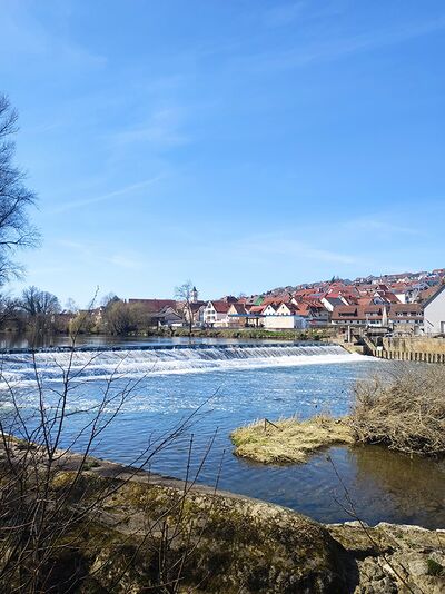
- The Neckar River in Nürtingen, part of the Stuttgart greater region is an ideal example to understand the impacts of global economic growth and industrialization on river landscape and ecosystems. At this particular location, the beauty of the valley carved by rivers flowing in harmony with surrounding hills, trees, orchard cultures, historical architecture, have always attracted many peoples and animals around this river.
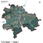
The Nürtingen historical center is built on the top of a hill, safe from flood and the city englobe few villages around such as Neckarhausen, Oberensingen, and Zizishausen who are benefiting directly from the river.
The challenges for the future of the Neckar river ecosystems are multiples. For instance, the rapid economic growth of the Stuttgart region has led to industrialization and urbanization of the riparian's area. The agricultural economic growth model has created a large demand for industrialization and has damage to the soil and its water retention capacities. The use of synthetic chemicals has created pollution in the soil, groundwater, and eventually in the river.
The global warming crisis is also an alarming challenge, it will create more draught, more flood, an increased in water temperature, and finally greater stress on the river biodiversity and sustainability.
Location and scope
You can edit this map with the map editor
Water as a natural system
Geomorphology, typologies and dynamics of water areas
- Describe the water areas of your area in the context of the wider water system
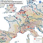
The Neckar River is located in the central part of Europe. Its main source of water for the Baden-Württtemberg Province in Germany and the source is located in the Black Forest at 706m of altitude, not far from the Danube River source(35km away). It flows from south to north into a 362 km long journey to eventually reach the Rhine River in France at 90m above sea level and ultimately share its water to the North Sea in Holland. The Neckar River flows through the foothill of the Alps, in the Swabian Alb region. The valley could be 400m deep in some area and the water pass through Tübingen, Nürtingen, Stuttgart, Heidelberg, and in the Rhine River at Mannheim Germany.
- (TO CORRECT)* The Neckar Valley water system can be first classified into three segments:*(WHY ONLY CLASSIFYING ONLY THIS PART, CONFUSION WITH THE WHOLE PICTURE OF THE RIVER)*
In the Northern, from Kirchheim to Stuttgart, the upper course is the closest to the source of River Rhine.*(TO CORRECT)* It's narrow and has steep gradients with vineyards, highly affected by vertical erosion and striking rock formation. It has a 6-meter height waterfall at DeisslingenLauffen, where rapids are occasionally seen in Lauffen which cause erosion. There's a gorge*(TO CORRECT)* found in the Odenwald the district of Neckargerach at Neckar.
In the Central, from Stuttgart to Plochingen, the middle course is characterized by Urban structure, cultural and landscape diversity where the river starts to slow down, get wider, and travels in a winding loop causing a lot of lateral erosion, transportation of the river soil and deposit. Floodplains, meander, oxbow are common characteristics of the Neckar River. Neckar’s oxbow appears after the *(TO CORRECT)*(WHERE WHAT IS THE LOOPS ?)Neckar loops were penetrated in the year 1933-1934 due to the expansion of canalization.
In the Southern, from Plochingen to Neckartenzlingen, the lower course is where the river gradient is gentlest. As the river approaches the sea, it has a wider smooth channel and moves to its slowest speed where large flood plains, deltas, and estuaries levees can be found. Here, navigation on the river is no longer possible. Orchards and Wood were also found with some residential and industrial areas
- How does water appear in the landscape of your living lab? What types of water areas are common?
Water appears in many forms depending on the natural geomorphology, typologies, and dynamics of its flow. In a wider context watershed, drainage basin, catchment area or the cultural or built environment by humans is also responsible for its appearance, the River, Lakes, Ocean, *(TO CORRECT)*Sea*(TO CORRECT)*, Tributaries, Streams, Puddle, Pond, Canals and Floodplains are the types of water areas that are common in the area.
- Please identify the water bodies' catchment areas, tributaries, and floodplains
Catchment: The catchment area dimension is 13,900 km2 and covers up to 40% of the Baden-Württemberg province.
Main Tributaries : Eschach, Prim, Schlichem, Glatt, Eyach, Starzel, Steinlach, Ammer, Echaz, Erms, Aich, Lauter, Fils, Korsch, Rems, Murr, Enz, Zaber, Schozach, Lein, Sulm, Kocher, Jagst, Elz, Ltter, Laxbach, Steinach, Elsenz.
Main Floodplains: Tributaries of river Neckar, Danube, Rhine, the Seine at the German state of Bavaria, Hessen, Rhine-Palatinate, Baden-Wurttemberg and North Rhine-Westphalia were affected floodplains
- Which dynamics do these water areas have?
The elevation of the western black forest mountains and the south-east Swabian Albs have a natural influence on the flow of the water. The valley of the Neckar River could be either carved in gently rolling hills or open up into vast plains.
Due to urbanization and industrialisation, we can observe that the river dynamics has been artificially modified by the construction of long and straightforward channelization and sifted from its original position at some location, resulting in an accelerated river flow and erosion of the banks.
- Have there been any flood events in the past?
Flew major flood events in central Europe have happened in the last two decades: • 1993, on Neckar catchment*(TO CORRECT)* • 2002, along the river Elbe. • 2016, after continuous heavy rainfall.
- add 2-3 graphical representations to the image gallery, you can add more if you like
Water as a living space
- Which habitats can be found in and along the water areas of your area?
Formation of habitats on the territory of the city Nurtungen has resulted to a combination of factors such as history, climate, geographical location, flora, and fauna of surrounding territories. The morphology of the territory also has a strong impact on the way of forming habitats. The city lies on the river Neckar, a mountain fast-flowing river, as well as a hydrographic network is represented by streams and small freshwater lakes. Leading development the city of Nuertingen, recapturing large areas of land, due to this, complex areas with alternating natural vegetation, farmlands, and urban territories are formed. Classification of habitats that can be found along and in the water of the river Neckar: Wetlands – marshy area, banks of the river, floodplain; Freshwater – riverine, streams, lakes; Urban – recreation, residential areas, gardening, and landscape design; Forest – old and young forests; Farmlands – pasture and orchards; Grassland – meadows, and slopes;
- How is the water quality in your water areas?
The Neckar in the territory of the Nurtingen runs through 3 dikes that slow down the river’s flow. In some locations can be found the dense settlement, especially along streams, and sewage treatment plants. As a result, a high nutrient proportion can be recorded, which leads to the significant development of algae during the summertime. The lack of oxygen due to the degradation of this organic material can be dangerous for many wetland and freshwater species. The warning level of continuously recorded oxygen by the power station is below 4 mg per liters. The level of pH of river water is also a very important parameter – the measure of hydrogen ion concentration. Low pH can be dangerous to immature fish and insects, while the high level of pH is also harmful to most organisms. The most optimal pH level which is considered for life – 7,4. The level with indicator 8.0 can be sufficient for most river species, but clams and snails usually prefer the higher level of pH. According to the last measurements the pH value in the river Neckar in the territory of the Nuertingen – 8,3.
- Which areas are still natural, which are urbanised/artificial?
The structure of the river and streams bodies is a very significant parameter, which contains bed and bank structures, course development, transverse and longitudinal profiles and watercourse environment. This parameter must be recorded because of two important reasons: - habitats should be available for well-being in and around the river; - flora should be naturally occurring in and along the river and streams; Baden-Württemberg water structure map shows that structure which was considerably changed and significantly changed with the largest share of the total assessments. There are about 40% of the river structure in an unchanged, slightly changed, and moderately changed condition. The results of structural completely changed class are composed of the waters that as a result of the individual parameters piped sections, this corresponds to approximately 20% of the total rated.
- Are the rivers permeable for fish or blocked by artificial elements?(approx 200 signs)
Since the Neckar river in the territory of the Nurtingen flows through 3 dikes it can block migration of fishes because these dikes have electro station and turbines, that dangerous for fishes’ lives. However, when analyzing and observing the river Neckar some artificial structures were sighted, next to the dikes, which provide an opportunity for free movement of fishes. These structures represented a new way for the fish migration separate from river flow towards to turbine. All calculations were done by specialists, according to the speeds of the river’s flow and observing the fish migration. These lots for the movement have stepped construction that allows fishes to have a rest after the long migration. In conclusion, the river Neckar has serious artificial elements that can block the movement of fishes, but some good solutions can be found along the river, so this part of the river is permeable for fish at this moment.
- add 1-2 graphical representations to the image gallery, you can add more if you like
Blue and Green Infrastructure
- What are the major potential elements of a green/blue infrastructure network? Are these likely to change/disappear? Why is that?
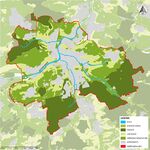
The Major potential elements of Blue Infrastructure are the main Rivers which flows in the region and their Streams. Major River which flows in the Nürtingen region are Neckar River, Steinach River, Tiefenbach River, and Aich River. Due to Settlements on Flood plains these are likely to change.
The Major potential elements of Green Infrastructure are Forest, Orchards, and Agriculture. Yes, Agriculture is likely to change due to growth of Urbanization.
- You find my background material on green infrastructure in our reading list
- add 1-2 graphical representations to the image gallery, you can add more if you like
Water as a cultural space
Land use and water
- map the land uses along your water areas: settlements, infrastructure, agriculture, resource extraction, natural areas, energy production...
- describe in particular the historical evolution of land use pattern, please make use of historical maps
Historically, Nürtingen center have been established on the top of a hill on the east shore of the Neckar River, preventing the populations from flood events. At that time, the landscape was transformed by local people involved into diverse kind of agricultures and wood logging activities.
However, from 1824 to 2021 in Nürtingen, we can observe a large transformation of the landscape and a very strong growth of the settlements. Some urban has sprawl down to the floodplain’s areas, and the agriculture field have become less diversified, wider and closer to the river.
- description evolution, status quo and driving forces, is the land use likely to change? Why is that? (approx 200 signs)
The strong economy of the Stuttgart region is a major driver of change in the urbanisation of the Neckar River. The industries have grown very quickly and create a rising demand for transport on the river. Electricity plants, construction of road and highway along the river, industrialization of agriculture have become common in the landscape.
The Stuttgart region significant and steady growth of its population and the scarcity of homes available is creating opportunities in real estate market to develop more space for living. And the Covid pandemic increase the demand of the population to relocate themself away from major urban centers.
The land occupation will change accordingly to the economic success of the Stuttgart region. New technologies such as electricity production will have an impact on improving the river ecology. Agriculture will also change eventually to a more nature base approach and allow biodiversity to occupy more of the territory. Due to the pandemic, working from home into the services industries will led to more urban sprawl. Hopefully, people will get in touch more with the river and the land so it can create new driver of change toward bio-diversified landscape and ecosystems balance.
- add 1-2 graphical representations to the image gallery, you can add more if you like
Cultural and spatial typologies of water areas
- Which spatial patterns have evolved in relation to your water areas?
- What is the role of water areas within the overall urban morphology? (approx 200 signs)
- add 1-2 graphical representations to the image gallery, you can add more if you like
- Yourcase water space1.jpg
add a caption
- Yourcase water space2.jpg
add a caption
- Yourcase water space3.jpg
add a caption
Sacred spaces and heritage
- Which places/elements hold cultural value and to whom?
- You may add a map and some images, please also explain in your caption why these elements are valuable
- Your case sacredspace1.jpg
add a caption
- Your case sacredspace2.jpg
add a caption
- Your case sacredspace3.jpg
add a caption
Visual appearance and landscape narrative
- Which elements are essential for the landscape character?
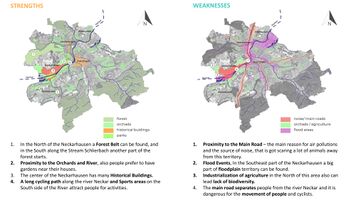
The most fundamental element of the landscape of Nuertingen is the river Neckar, its streams, and its riverbanks. The city lays on seven hills, which are used for different purposes, such as agriculture fields, vineyards, and pastures. Some forest belts can be observed in the north and in the south of the city, which are very important habitats for animals and vegetation diversity. Citizens enjoy hiking and cycling, using unique routes which pass through these beautiful landscapes.
- Has the landscape been painted or otherwise depicted, when and whom? Which elements are essential?
Andreas Kieser german cartographer painted a view of the city of Nuertingen from the forest on the other side of the river Neckar in 1638 year. This painting can be found in Andreas Kieser's warehouse books. This view contains a representation of the central tower, the historical center of the city, and the view of the river Neckar with two streams.
- Which narratives exist? Who has written about this landscape or depicted it in some way?
Mark Twain known as the father of American literature have visited the Neckar River. He depict how much the river being on the river was a peaceful and resourceful experience : “Germany, in the summer, is the perfection of the beautiful, but nobody has understood, and realized, and enjoyed the utmost possibilities of this soft and peaceful beauty unless he has voyaged down the Neckar on a raft. The motion of a raft is the needful motion; it is gentle, and gliding, and smooth, and noiseless; it calms down all feverish activities, it soothes to sleep all nervous hurry and impatience; under its restful influence all the troubles and vexations and sorrows that harass the mind vanish away, and existence becomes a dream, a charm, a deep and tranquil ecstasy. How it contrasts with hot and perspiring pedestrianism, and dusty and deafening railroad rush, and tedious jolting behind tired horses over blinding white roads!”. ― Mark Twain, A Tramp Abroad "
- You can add text and images
- Your case character2.jpg
add a caption
- Your case character3.jpg
add a caption
Water and People
Accessibility and usability
- Where are your water areas accessible, and where not? How strong are spatial obstacles preventing access?
According to survey analysis, only a small part of the river Neckar in the territory of the city Nuertingen is accessible for people – a cycling and walking path from the center to the sports area on the southern part of the river and a small area on the northern part of the riverbank between two pedestrian bridges. Other parts have serious problems with access to the river, especially Neckarhausen, which is separated from the river by the main and noisy Neckarstrasse road. Also, the residential area along the Muhlstrasse has constructions and “jungle” river banks that prevent people from visiting river Neckar.
- Who is using the spaces and how?
Citizens of Nuertingen enjoy walking along the river, such as older people and young families with children, people who love to do sports activities, such as cyclists and joggers can be found in the territory of riverbanks. Also, fishermen choose the south side of the river for fishing because this area has the quiet atmosphere for animals.
- Yourcase youraccessbilitymap.jpg
add a caption
Community Mapping
What is to be mapped here?
- Social groups from within the community, for example the youth, kids, students, parents, the retired etc. Typically, these groups have specific needs, which you can also make explicit on the map. These people might not be organized in any way, but they are usually present in the context you are observing
- Local stakeholder groups: these groups are organized in one or the other way. They only exist within the community context you are observing. For example: the local community center, local churches, local interest groups, the landowners, small businesses and retailers
- External stakeholder groups are not necessarily present in the environment you are observing, but they may have strong stakes and interests. These can be local authorities, politicians, associations, care services etc.
- For each group, you may identify their needs, objectives, power and capacities
- You may also identify gaps and power conflicts
- Please try to redepict these elements in an integrated way and in relation to your water landscape. What is the relationship between these groups? Are they close or distanced from each other? Who is more powerful? Which voices are hardly heard? Do they have any shared concerns?
- Your case your community map3.jpg
add a caption
Possible Futures
- You can summarize your findings with a SWOT diagram and a DPSI(R) Model
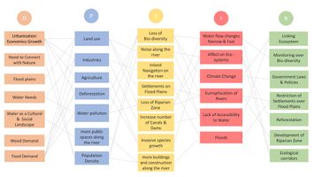
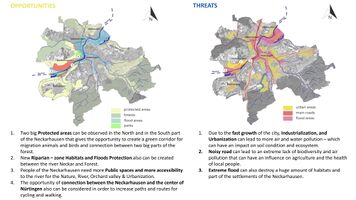
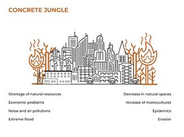
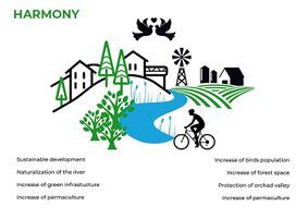
We have Identified some Drivers that can change the Landscape of the Region. The Drivers we have Identified are Urbanization, Water Needs, Water as a cultural & Social Landscape, In Response to this we can link Ecosystem, Monitor over Biodiversity, Create Ecological Corridors, Reforestation and Restriction of Settlements over Floodplains.
- Link back to the Sustainable Development Goals: Which goals are at risk?
- What is your worst case scenario for this landscape?
- What is your best case scenario for this landscape?
- Present your scenarios in the form of a collage or sketch
- Add text and visuals
Collaborative Goal Setting
- Define strategic planning objectives based on the evaluation findings from your analysis
- Ideally, involve the community of your living labs into this process
- Link back to your original targets from section one and the Development Goals
- 150 words text contribution
Spatial Strategy and Transect
- translate your strategic goals into a vision
- develop a spatial translation of your vision
- exemplify your vision in the form of a transect with concrete interventions
- add map(s) and visualizations
- Your case spatial translaton vision.jpg
add caption here
- Your case transect.jpg
add caption here
- Your case transect detail1.jpg
add caption here
- Your case transect detail2.jpg
add caption here
From Theory of Change to Implementation
- For implementing your vision: Which partnerships are needed? Which governance model is required?
- Who needs to act and how? Draw and explain a change/process model/timeline
- Which resources are needed? On which assets can you build?
- add 150 words text and visuals
References
- give a full list of the references you have used for your case
Process Reflection
- Reflect in your intercultural and interdisciplinary team on the outcomes of your study
- Which limitations were you facing?
- What have you learnt from each other?
- What did you learn in the Living Labs?
- What would you do differently next time?
- You can also use diagrams/visuals
- 250 words text
