Freising Waterscapes Team 2 2022
>>>back to working groups overview
| Area | River Moosach | |
| Place | Freising | |
| Country | Deutschland | |
| Topics | please enter the main topics of your living lab | |
| Author(s) | Vulnet Abazi, Boglárka Bartus, Brent van der Brug, Dino Jozic and Niusha Vedadi Moghadam | |

| ||
Rationale
- Why do you think this case is relevant? What is your hypothesis considering the landscape challenges?
- Format: 3-4 sentences
Location and scope
You can edit this map with the map editor
Water as a natural system
Geomorphology, typologies and dynamics of water areas
Context

As a tributary of Isar and Amper, the river Moosach is part of the Danube river Basin. It's course runs in the north of Munich, in parallel with the suthern parts of tertiary sloping land and through a gravel plain which had paludified over time. As it runs through the gravel plain, it drains the large peatland areas ‘Freisinger Moos’ and ‘Dachauer Moos’, eventually transitioning through the unpaludified parts of the plain. The Moosach is characterized by the occurrence of several aquatic plants such as Juncus subnodulosus, Potamogeton coloratus, and Groenlandia densa, which clearly indicate that the Moosach is olygothropic and fed by calcareous-rich groundwater. (Poschlod, et al., 2010)
Water areas
-
 From almost everwhere you can see the Weihenstephanerberg.
 -
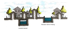
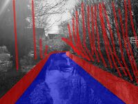
 In Freising the Moosach is canalized in concrete.
 -
 People have a personal garden at the Moosach.
 -
 The Moosach flows next to the Lower Bavarian hills.
 -
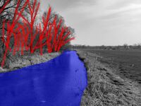
 The Moosach flows next to agricultural lands.
 -
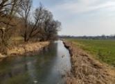
 The Moosach flows through open fields.


Both river Isar and Moosach have changed a lot in relatively recent times, thus they have a very artificial appearance due to human impact and exploitation of these two rivers as natural resources over the past centuries. The river Moosach in particular has several specific cathegories of appearance. From south to north the river morphs from a highly channeled water stream into the damp Freisenger Moos area. After that it's appearance transforms into a more natural one as it enters the city of Freising through the forest area beneath the Weihenstephan hill. From there on it splits into several very different parts which run through Freising. One part which was until recenly completely ducted is now resurfacing through a large scale infrastructural intervention. The other parts are respectfully either surrounded by buildings or green areas. As these several parts exit Freising they reuinte into a single riverbed.
Flood plains

The river Moosach is a tributary to river Isar, but since the stream Mühlbach splits away from it carrying 30% of the water to river Apmer, Moosach can also be considered a tributary to Amper aswell. The foodplains of river Isar are contained by a natural buffer zone arround it, but due to the highly artificial waterway management of Moosach before and after it enters Freising and a lack of apropriate buffering from the urban tissue of the city, the region beneath the Weihenstephan hill is in a risk of potential floods which could cause substanial damages. One of the recent examples has proven this risk has be substantial, as several streets in Freising were under water in the night of June 3, 2013, when the Schleifer-Moosach suddenly overflowed its banks. (Eser, 2021)
Risks and potentials

Water as a living space
Habitats

There are several important habitats in the project which are closely tied to water bodies and need to stay protected, potentially expanded and even connected. These habitats are: Ampertal habitat, Kammolch habitat, Heideflächen und Lohwälder habitat, Freisinger Moos habitat, and Isarauen habitat. The Isarauen habitat is the largest and best preserved habitat, as the natural buffer zone around river Isar provides the best conditions for preservation of uniform environmental conditions which the biotope essentially requires. However, the Freisinger Moos habitat is as biediverse as the Isiarauen, but due to systematic neglection of the area and overexploitation of the natural resources of river Moosach and the areas around it, the once large Freisinger Moos has shrunk to the size it now has. Due to this fact many of the species that inhabit this biotope are endangered today and the Freisinger Moos became an important area of natural protection and preservation. (FORM, 2021)
Water quality

Essentially none of the water areas in the project area are natural, but some of them appear more natural and appealing. For example, the part of river Moosach between the Freisinger Moos and the foot of the Weihenstephan hill that runs in dull straight lines is less appealing than the part where Moosach enters Freising and the spatial configurations and visual narratives of the river become more dynamic and interesting.
Blue and Green Infrastructure
Blue and Green infrastructure

The difference between the BGI focus placement between the rivers Moosach and Isar is more than obvious. The BGI of the larger river Isar is established much better, as the natural buffer zone arround the river allows for a homogenous continuity of ecosystem services along the riverbed. On the other hand, the discontinuous zoning of river Moosach, along with a general disregard towards the rivers natural identity in the past, has led to a BGI which encapsulates the ecosystem services of the Freisenger Moos to a fraction of the surface it once covered and endangers the existance of the weakest stakeholders of the ecosystem.
Water as a cultural space
Land use and water
Land-use
- map the land uses along your water areas: settlements, infrastructure, agriculture, resource extraction, natural areas, energy production...

(insert text)
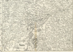
- describe in particular the historical evolution of land use pattern, please make use of historical maps
(insert text)
- description evolution, status quo and driving forces, is the land use likely to change? Why is that? (approx 200 signs)
(insert text)
- add 1-2 graphical representations to the image gallery, you can add more if you like
(insert text)
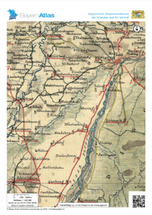
Map of 1857 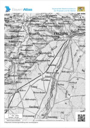
Map around 1860 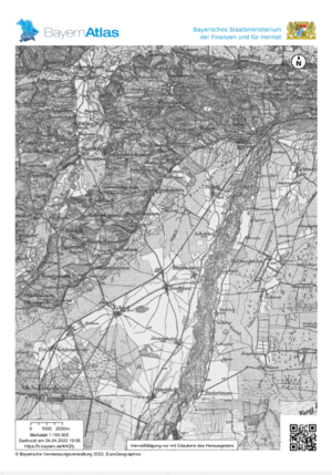
Map around 1900 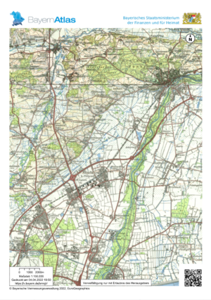
map of 1985


Cultural and spatial typologies of water areas
Spatial patterns
-
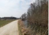
 The Moosach as a ditch next to the road (Pulling to München).
 -
 The Moosach in the open (in between Pulling and Freising).
 -
 The Moosach in Freising (above- or undergound).


In the historical cultural context, the rivers were one of the most important aspects for existance, mobility, transport of resources and trading. Due to this reason all human settlements of the inlands tend to be close or directly next to streaming water bodies. In the context of contemporary cultural landscape of Freising, the rivers upon which the city evolved play a major role for preservation of culture. This implies that the society in Freising has a strong tendency to restore the river Moosach to it's natural state to the extent that is possible. Moosach has various spatial patterns along the course of its stream, patterns which have shaped the urban morphology of the rural and urban areas, as well as the cultural landscape of Freising. Even though Moosach is severely altered due to human needs, it still represents the main artery of the cultural bloodflow in the city, since some of the most beutiful places of Freising, both natural and artificial in terms of visual appearance, are directly tied to the river branches.
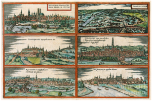
Four settlements in Bavaria 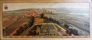
Map of 1531-1589


Sacred spaces and heritage
Sacred places

The history of Freising County has been organically linked to religion since the first centuries. The religious central role of Freising associated with the name of Corbinian Bishop. This spiritual life left its landmarks, which even nowdays are highly identity-forming for the ones who live here. Also the smaller marks, as the wayside crosses are important, because most of the time they were set up by the inhabitants of the villages and show the trail of the former road network. They also help with orientation.
The two sacral spaces which hold cultural value for the locals, especially for the catholic religious community, are the Freising Cathedral located on the Domberg and the former Corbinian chapel located on the Weihenstephanerberg. The Freising Cathedral holds value since it is still being used as one the important spaces for everyday prayer in Freising, and the Corbinian chapel is important because it serves as a memorial preserving the memory of a centuries-old local legend which shapes the identity of Freising to this day. Other than the important sacral heritage, Freising cherrishes it's brewing tradition, as the worlds oldest brewewry located on Weihenstephanerberg operates to this day.
Visual appearance and landscape narrative
Visual appearance
The essential elements of the large scale visual landscape character are the important spatial determinants (old core of the city, the two hills, the water bodies, etc.) , traditional local practices (gardening, brewing, etc.), and the increasing awareness of the importance of ecology (riverbed restoration plans and projects already in implementation). Freising had beeen depicted in many historical paintings. The most notable one in the context of Freising landscape representation is probably the aerial view painting from a series depicting possessions of the Freising Bishopric in the princely corridor between the prince-bishop's residence and Freising Cathedral painted by Valentin Gappnigg in the late 17th and early 18th century. This painting in particular is very important because it represents well the different landscape typologies, from the Freisinger Moos and Moosach, over the Isar in the distance, the gardens on Weihenstephan, the farmlands left of weihenstephan and the urban tissue od Freising. The many different narratives of the specific project area that exist today have been extensively written about by many researchers from different fields, from the context of geomorphology and water quality (Poschlod, et al., 2010), over the context of flood risk governance (Snel, et al., 2022), to the risk for biodiversity and endangerment of native species caused by other invasive species in the river (Wutz & Geist, 2013), etc. The main new narrative that is emerging in the visual context is the restoration of river Moosach. (Schnetz, 2020)
-
 View of the Weihenstephanerberg.
 -
 Open spaces.
 -
 Next to the forest.
 -
 City park.
 -
 City park 2.
 -
 In between buildings.
 -
 In between buildings.
 -
 In between buildings.
 -
 Next to the mountain.


- Has the landscape been painted or otherwise depicted, when and whom? Which elements are essential?
(insert text)
- Which narratives exist? Who has written about this landscape or depicted it in some way?
(insert text)
Water and People
Accessibility and usability
Accessibility
-
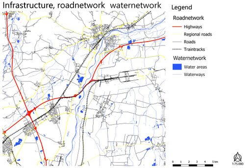 Road and waternetwork for the whole plan area.
 -
 The road and waternetwork, zoomed in at the Freisinger Moos.


Most parts of the riverbed of the Moosach branches within the urban tissue of Freising are accessible in terms of visusal connectivity, but not so many parts of the river within the city can be directly phisycally accesed due to the artificial embankment of the riverbed. Those areas than can be phisically acessed in the city have high functional and aesthetical values. As we exit the urban area of freising and go further up the stream towards the Freisinger Moos area, the riverbed becomes becomes more natural in terms of it's green surroundings, but the pedestrian and cycling mobility infrastructures along the riverbed soon dissappear and direct phisycal accessibility is harder to achieve.
Community Mapping
Social groups

The dominant social groups which use the river Moosach for recreation purposes such as strolling, biking, swimming, and playing next to it are families with children, the students, the elderly, the disabled, etc. Each of these group has specific needs in terms of safety, accesibility, and usage of the river. For example, chiledren playgrounds need to be properly distanced and separated from the water, otherwise good visual communication between the playgrounds and the water must be established so that the kids parents or caretakers can properly survey them. The elderly and the retired need to have appropriate acces points to the riverbed, like ramps and staircases with gentle slopes, as well as places where they can rest while stroling along the riverbed. The students and some other social groups like to swim in the river from time to time, and appropriate swimming areas need to be mapped out and defined accordingly.
Local stakeholders
The local stakeholders such as the ecologists, NGOs, and farmers may have conflicting interests, in the terms that the plans for Moosach riverbed restoration might cause power conflicts between these stakeholders if the needs of the farmers are not met in the new river restoration designs.
External stakeholders
The external stakeholders such as the Green Party have large external influence on wether the plan to adapt the river to mittigate the climate changes, reduce the risks of flooding, and promote the cultural connectivity and accessibility to the river.
Needs, objectives, power and capacities
-
 The community needs.
 -
 The community power mapping.


Power conflict

Possible Futures (WIP)
SWOT analysis

(insert text)
DPSIR

Worst case scenario (WIP)
- What is your worst case scenario for this landscape?
(insert text)
Best case scenario (WIP)
- What is your best case scenario for this landscape?
(insert text)
Scenarios (WIP)
- Present your scenarios in the form of a collage or sketch


-
 Green renaissance, spider diagram
 -
 Wild west, spider diagram
 -
 Urban Sprawl, spider diagram
 -
 Parasite cities, spider diagram
 -
 All spider diagrams combined.


(insert text)
Visualizations (WIP)
(insert text)
Collaborative Goal Setting
- Define strategic planning objectives based on the evaluation findings from your analysis
- Ideally, involve the community of your living labs into this process
- Link back to your original targets from section one and the Development Goals
- 150 words text contribution
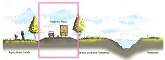
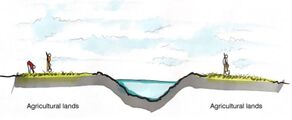
Spatial Strategy and Transect
- translate your strategic goals into a vision
- develop a spatial translation of your vision
- exemplify your vision in the form of a transect with concrete interventions
- add map(s) and visualizations
-
add caption here
-
add caption here
-
add caption here
-
add caption here
From Theory of Change to Implementation
- For implementing your vision: Which partnerships are needed? Which governance model is required?
- Who needs to act and how? Draw and explain a change/process model/timeline
- Which resources are needed? On which assets can you build?
- add 150 words text and visuals
References
- Eser, M., 2021. merkur.de. [Online]. Available at: https://www.merkur.de/lokales/freising/freising-ort28692/freising-starkregen-welche-regionen-im-landkreis-gefaehrdet-sind-90893333.html. [Accessed 20 May 2022].
- FORM, N. 2. -. S. D., 2021. Kammmolch-Habitate im Kranzberger Forst. [Online]. Available at: https://natura2000.eea.europa.eu/Natura2000/SDF.aspx?site=DE7535371. [Accessed 20 May 2022].
- Poschlod, P. et al., 2010. Long-Term Monitoring in Rivers of South Germany Since the 1970s – Macrophytes as Indicators for the Assessment of Water Quality and Its Implications for the Conservation of Rivers. In: Long-Term Ecological Research. London: Springer Dordrecht, pp. 189-199.
- Schnetz, W., 2020. merkur.de. [Online]. Available at: https://www.merkur.de/lokales/freising/freising-ort28692/innenstadtsanierung-in-freising-wurde-moosach-geoeffnet-13803087.html. [Accessed 20 May 2022].
- Snel, A. K. et al., 2022. Unpacking notions of residents' responsibility. Environmental Policy and Governance, Issue Special issue article, pp. 1-15.
- Wutz, S. & Geist, J., 2013. Sex- and size-specific migration patterns and habitat preferences of invasive signal crayfish (Pacifastacus leniusculus Dana). Limnologica, 43(2), pp. 59-66.
Process Reflection
- Reflect in your intercultural and interdisciplinary team on the outcomes of your study
- Which limitations were you facing?
- What have you learnt from each other?
- What did you learn in the Living Labs?
- What would you do differently next time?
- You can also use diagrams/visuals
- 250 words text