WAVE Living Lab Neubrandenburg 2021: Difference between revisions
David.pulido (talk | contribs) |
David.pulido (talk | contribs) |
||
| Line 237: | Line 237: | ||
<gallery caption=" " widths="200px" heights="150px" perrow="5"> | <gallery caption=" " widths="200px" heights="150px" perrow="5"> | ||
File: | File:Carl Gotthold Heinrich Arndt, Neubrandenburg, 1775.jpg|'' | ||
File:your case_character2.jpg|''add a caption'' | File:your case_character2.jpg|''add a caption'' | ||
File:your case_character3.jpg|''add a caption'' | File:your case_character3.jpg|''add a caption'' | ||
Revision as of 17:01, 3 May 2021
>>>back to working groups overview
| Area | Tollense Lake | |
| Place | Neubrandenburg | |
| Country | Germany | |
| Topics | please enter the main topics of your living lab | |
| Author(s) | Please enter your name(s)- optional | |

| ||
Rationale
- Why do you think this case is relevant? What is your hypothesis considering the landscape challenges?
- Format: 3-4 sentences
Location and scope
You can edit this map with the map editor
Water as a natural system
Geomorphology, typologies and dynamics of water areas
- Tollense Lake in Wider Water System
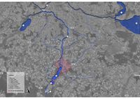
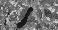
Tollense Lake is located Southwest of the city of Neubrandenburg, Mecklenburg-Western Pomerania, Germany. It has a length of 11 Km and a width of 2.5 m. The Tollense Lake has an area of 17.350 km2 and a depth of 34 m and it lies in an ice age tunnel valley. It is well-known for family spot holidays caused it rated as good quality of water, which means people are allowed to swim in the Lake. Tollense Lake is a very important water area due to its connectivity. It connects to the Tollense River which is the right tributary of the Peene river. From Peene River the river flows to Szczecin Lagoon and Achterwasser, Achterwasser has direct connectivity to the Baltic Sea. Towards Southwest of Tollense Lake, there is a village called Blumenholz. In Blummenholz, Mürzsee is the beginning of upstream of Tollense River. From Mürzsee, a river called Zimmenbach flows into Lieps Lake. From Lieps Lake, Alter Graben River flows from Lieps Lake into Tollense Lake. From Tollense Lake, it has two branches of Oberbach and Ölmühlenbach then both flow into Tollense River. Both branches unite after approximately 1.6 Km.
- Catchment Area, Tributaries, Floodplains of Tollense Lake
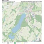
The Tollense Lake has the longest and most water-rich tributary called Nonnenbach, while the Tollense river has tributaries such as Lindebach. Lindebach is one of the important tributaries due to its flow reaching the Lindetal district, eastern of Neubrandenburg. Another important tributaries is Datze river on the North of Neubrandenburg, Torneybach, gold Bach, Großer Landgraber and Augraben river that are near to Demmin (the end of Tollense River). According to the Geoportal website of Mecklenburg Vorpommern, the floodplains of Tollense Lake and Tollense River are mapped mostly adjacent to part of the built area of the city. The catchment area is shown in the picture below.
- Dynamics of Tollense Lake
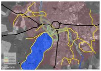
In 1900, there was 10,500 inhabitant in Neubrandenburg. It grew to 30,449 inhabitants in 1958. As the picture below, the built area was dense near to inner ring of the city, while the green area was dominated around Tollense Lake. In 1991, the built area was developed into the Northeast of Tollense Lake. Presently, the built area has grown into the East and the Northwest of Tollense Lake. In summary, the South, Southeast, and Southwest area of Tollense Lake are still dominated by green areas. The Tollense Lake was formed during the last Ice Age, 15.000 years ago or more than Vistula Ice Age. During Ice Age, the landscape was chains of hills, sand areas, numerous streams, and smaller lakes. Tollense Lake is derived from the Slavic "dolenzia” which means Lowland. The landscape area of Tollense Lake has been known as a glacier tongue basin over a longer period of time. The Tollense Lake is famous for a family holiday spot. There are facilities around the lake that responded to the modern needs of citizens and tourists, the facilities such as passenger shipping, restaurants, cafes, cycling route, and areas for swimming have currently existed.
There was no flood event as recorded around Tollense Lake and Tollense River. However, there is a potential risk of flooding that is mapped below. The water level of this area is rated from Normal to High, and has not reached a warning level.
In Neubrandenburg, we mostly find water canals that originate from the Tollense Lake, which creates a harmonious water system which is connected and refreshing. Water in Neubrandenburg comes mainly from the Tollense river, a freshly mixture of various sea and freshwater sources, in the landscaping area, the Tollense supplies the water canals all the necessities for agricultural production and offers opportunities for new agricultural experiments, thus playing a key role in shaping the environment by establishing a dominant river valley that connects the entire city of Neubrandenburg with its water sources.
Water as a living space
- Habitats in and along the Tollense Lake
In and alon this water area, we see a diversity of plant species and different organisms.
Among the available plant species,the following can be mentioned: Downy birch,horse and sweet chestnut,Juniper,European Larch,Juniper,Black Locust,European Wild Apple, Cherry, Elm, European Beech,Ash, Hazel, Spurce, Alder, Pine tree ,Willow,Mursh Marigold,Marine plants(like Elodea Canadensis ) and etc.
Respecting the animals in this area, we can mention the diversity of fish ( like European Perch ,common Rudd,Vimba Bream,Blicca Bjoerkna and Trout),waterfowl, frogs, and between trees we can see, squirrels, rabbits, foxes, boars, etc., which are easily visible to visitors and residents.
Waterfowl at Tollense lake and adjacent waters:
Winter visitors: singing swan, white swan, bean geese, lesser swan, goosander, lesser scoter, common scoter , white-fronted goose.
Breeding birds: Great crested grebe, mallard, goldeneye, coot, moorhen, gadwall, cormorant, mute swan, pond warbler, great reed warbler, pochard, tufted duck, pochard, white-tailed eagle, osprey, kingfisher, laughing gull, mew gull, herring gull, Egyptian goose, greylag goose.
- Yourcase wateraslivingspace1.jpg
add a caption
- Yourcase wateraslivingspace2.jpg
add a caption
- Yourcase wateraslivingspace3.jpg
add a caption
- How is the water quality in your water areas?
- Which areas are still natural, which are urbanised/artificial?
The significant changes in the areas around is the growth of population and depletion of forest and farmland mainly toward the north-western side of the lake. The addition of recreational spaces and landscape activities serve the tourist attraction to the Tollensesee. Among the artificial structures like bridges ,pathways , playgrounds ,cemetery , restaurants and fish ladder, boat club on the Oberbach , and the Fisherman's house are tourist attractions.
Fish ladder
A fish ladder, also known as a fishway, fish pass or fish steps, is a structure on or around artificial and natural barriers (such as dams,locks and waterfalls) to facilitate diadromous fishes natural migration as well as movement of potamodromous species . Most fishways enable fish to pass around the barriers by swimming and leaping up a series of relatively low steps (hence the term ladder) into the waters on the other side. The velocity of water falling over the steps has to be great enough to attract the fish to the ladder, but it cannot be so great that it washes fish back downstream or exhausts them to the point of inability to continue their journey upriver.
'Fisherman's house on the fishing island in Lake Tollense'
The island in the southern part of Lake Tollense in Mecklenburg-Western Pomerania can already look back on a long history, the listed fisherman's house tells of this only the last section of the dwelling of the fishermen since the 18th century, which is still visible today. In addition to the authentic experience of the historical development of this region, nature conservation also plays an important role. If a long-term conservation perspective is to be developed for the building, which has been vacant for more than 20 years, a compromise must be sought, which will certainly only be found with mutual understanding and constructive dialogue and a responsible owner. According to the council minutes of the city of Neubrandenburg from 1729, the proposal to build a new house on the fishing island in the southern Tollensesee can be found. The construction is decided and carried out by Zimmermann Tröger. Fishing on Lake Tollense played a decisive role in the nutrition of the population for a long time, the island served as a shelter and refuge for the fishermen in GDR times. The two-storey and at the core baroque half-timbered building with splet roof has a wide central hallway with a brick stove and allows its structure according to the comparison to the so-called Ernhäuser (Middle German cross-floor houses).
The building is still owned by the city of Neubrandenburg – probably one of the oldest municipally owned residential buildings in the country. After a last backup was carried out in 2006 as part of an AB measure, the stock is now, 14 years later, acutely endangered again by the progressive decline and long vacancy favoured in a remote situation. Currently, the implementation of an emergency security with financial support of the State Office for Culture and Monument Conservation Mecklenburg-Vorpommern is planned.
- The permeability for fish or blockage by artificial elements
The presence of different types of fish in lakes and rivers is always one of the beauties of a water area that increases its spatial value. It is necessary to study the obstacles in the movement of fish along rivers, canals and lakes. Therefore, it is very important to pay attention to this issue in Tollensesee(lake) and its canals which branch into Oberbach and Ölmühenbuch creeks. So, in this section, this issue can be considered in the three main sections of Tollense Lake, Oberbach and Ölmühenbach creeks.
Tollense Lake
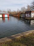
As the largest water basin, has favorable conditions for the movement and life of fish, and there is no artificial barrier that blocks the movement of fish. Even though it is widely used by visitors and used for recreational and sports purposes, the fish can still be clearly seen near the shore.
Ölmühenbach creek
Evaluation of the Ölmühenbach shows that the number of fish is less than near the shore, which is normal due to the decrease in water volume, but in the middle of the canal, due to the existence of a bridge structure that has changed the height by several meters, installing a fishway will keep the a proper condition for the movement of fish, which is ecologically necessary. As a result, it can be said that the movement cycle of fish is preserved.
Oberbach creek
In the case of the Oberbach, we see different conditions. And the presence of fish and their movement continues to the intersection of Rostocker Street, and this movement of fish is possible to this point.But from this point toward Tollense river, existence of overpass bridge, structure of it and waterfall changes height by around 4 meters and lack of a fish-ladder, cause a blockage in the movement of fish in this point. As a result, it is not possible for fish to proceed along this creek, which has created adverse condition.
- add 1-2 graphical representations to the image gallery, you can add more if you like
- Yourcase wateraslivingspace1.jpg
add a caption
- Yourcase wateraslivingspace2.jpg
add a caption
- Yourcase wateraslivingspace3.jpg
add a caption
Blue and Green Infrastructure
- Blue and Green Infrastructure
These infrastructures around Tollensesee lake area are impressively well preserved and represented by a variety of green/blue elements (artificial/ natural) which seems not likely to significantly change or disappear in the nearest future.
For the Blue Infrastructure
Neubrandenburg is located in the north part of the Lake Tollensesee and also the river Tollense that spread in different canals around the city. The lake in Neubrandenburg in Mecklenburg-Vorpommern, Germany. The lake Tollense is a lake in the northeastern part of the city. The main waterbodies are the Lieps Channel, three brooks, the Krickower Bach and Nonnenbach in the southern part of the lake and also the Gaetenbach in the north> The Olmuhlenbah and the Oberbach in Neubrandenburg. It has an elevation of 14.8 m with an approximately area of 17 km². The lake is 10.4 km long and about 1.5 to 2.5 km wide. Lake Tollensesee has low flood risk, also ESG Risk Index is low. Water stress is low-medium, Tollensesee lake has a good quality of drinking water and High level of wastewater treatment but it has drought medium-high risk. Coastal Eutrophication Potential and drought risk is medium high.
For the Green Infrastructure
Neubrandenburg Tollensesee Lake is surrounded by a green surface that preserves the lake from the city life within the lake the surface its 10,440 hectares, in and around this water area, there is diversity of plant species and different organism.
For the Gray Infrastructure
Neubrandenburg possesses s strong urban development that is not well related with the Tollensesee, buildings, houses, bridges, streets. All those daily life elementes for city development do not relate spatially with the lake, however, they do not affect it in the constant growth of the city in the near future.
- Are these likely to change/disappear?
Blue
Neubrandenburg blue infraestructure has a well preserved lake and river and not likely to disappear in the nearest future. Here are some reasons • The water bodies in Neubrandenburg Increased aesthetic and amenity values of landscape and increased eco-tourism • Improved water regulation and surface runoff and protection from flooding • Wetlands, grassed areas and urban forests around the lake reduce the risk of flooding, sewage overflow and clean water contamination.
Green
The green is well preserved and not likely to disappear • Neubrandenburg around the Tollensesse Lake the Greenways and greenbelts are corridors of undeveloped land and parks of rural land that are surrounding the lake and the city. • The pedestrians and bridges are structures that connect two areas of nature and allow wildlife to travel across nor very signi¬cant barriers, such as roads, human made canals • Urban elements, such as parks, gardens, yards, sports pitches, urban ponds and canals do not affect the cleanliness of the lake • Public Park, pathways, playing ¬fields, cycle paths and jogging tracks that encourage outdoor activity and promote good physical health.
Water as a cultural space
Land and use water
Cultural and spatial typologies of water areas
Sacred spaces and heritage
- Fischer Island
Fisher Island is a small island located in the Southwest of Tollense Lake, in front of the city of Penzlin. The island has 150 m in length, 40 m wide, and currently covered by vegetation. In the middle of the island, a fishing hut was built in 1729 and still used in 1970 by fishermen who spent a night. The island was believed to be a center of the Slavic tribe Veleti-Rethra. In 1969, the Archeologist found a figure of Lel and Polel. It is a cult of twin deities of Slavic mythology. In 1977, Hartmut Boeck, a German archaeologist discovered a 40m x 14m rectangular place in the Northeastern Island. In 1905, an excavation by Gustav Oesten found pieces of charcoal and ceramic shells in that place, it indicates a settlement of Slavic worship. It is believed an island is a place of Rethra, the main town, political center, major worship center of Slavic Redarians (one of Lutician tribes)
- Belvedere
Belvedere is located on the North shore of Tollense Lake. In 1775 the Duke of Mecklenburg-Strelitz, Adolf Friedrich IV. built a summer house on a hill. Until then, it was torn down. However, in 1823 grand duke Marie built a summer house at this place in the form of a Greek temple. The house was designed by Wilhelm Buttel. In 1934 Belvedere is converted into a memorial for the dead soldiers of the First World War from Mecklenburg-Strelitz by the architect Heinrich Tessenow. In 1995 the building was restored as an open temple.
- Amthouse Broda
Amthouse Broda is one of the oldest buildings in Neubrandenburg. A monastery of the Premonstratensian friars was built in In founded around 1170. The construction took time in 1230 and 1240. It is later converted into an official residence Broda with a manorial economy. In the 17 century, this medieval building was almost collapsed. In 20 century, Amthouse Broda was restored as a residential and office building. In 2004 it has been functioned as a guesthouse for International scientists by Hochschule Neubrandenburg.
- The Alter Friedhof
The cemetery of Alter Friedhof is located at the Tollense Lake at Seestrasse, it is a quiet and also a hidden area where the graves are positionned fronting the Tollense lake at the playground directly in front of it called the open Seeperle playground where families get together and play with their kids. The graves have recently been renewed, located within a wide green space with tall trees who seem like they’re protecting the entire area. This sacred place presents its self also by paying respects to the dead of the victims of the world war 2 which has had major and dire effects on the four gated city of Neubrandenburg in which many souls were sadly either sacrificed or murdered in the infamous year of 1945, this space has a very high value, it is considered to be a silent highly valuable sacred space at the Tollense Lake.
Visual appearance and landscape narrative
- Which elements are essential for the landscape character?
The elementes that have been painted or illustrated are :
• Tollense River originating from Tollense lake in Neubrandenburg towards its downstream end in Demmin, and land use in Tollese river catchment from Klempenow to Demmin
• The Neubrandenburg city fortification is “the most completely preserved example of a medieval city fortification in the brick building area” About 2,300 meters in length, the medieval city wall up to seven meters in height still completely encloses the old city center. Embedded in the almost circular wall ring are four outstanding late Gothic city gates from the 13th to 15th centuries (Friedländer Tor , Stargarder Tor , Treptower Tor and Neues Tor), numerous Wiekhäuser (guard houses) and the Fangelturm, due to the wall and brick gates Neubrandenburg possesses the nickname “city of four gates”.
• Also the main parish church of St. Marien , consecrated in 1298, renovated by Friedrich Wilhelm Buttel after several fires in the 19th century , burned down in World War II and converted into a concert hall from the 1970s to 2001, is now internationally renowned as a concert church, as well as the Franciscan monastery with St. Johannes monastery church.
• The four-wheel mill, which has been home to several dining establishments since it was closed in the 1990s and subsequent renovations.
• The chapel of St. George from the 14th century.
- Has the landscape been painted?
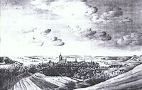
Carl Gotthold Heinrich Arndt: Neubrandenburg, 1775
Carl Gotthold was a German Evangelical Lutheran clergyman and provost at Ratzeburg Cathedral. The painter Carl Wilhelm Götzloff, captured by his enthusiasm for Gothic, composed his winter landscape with a Gothic church from 1821 based on the model of his teacher Caspar David Friedrich. In a review of the picture it was said: "Like this he seems to be fleeing beautiful leafy trees, clinging to coniferous wood, snowstorms, churchyard, moonlight, etc."
Neubrandenburg by Caspar David Friedrich
Caspar David Friedrich: Neubrandenburg, 1816 and Caspar David Friedrich: Burning Neubrandenburg, around 1835
The paintings of Neubrandenburg by Caspar David Friedrich who was a German painter, graphic artist and draftsman. Today he is considered to be one of the most important artists of early German romanticism who knew the city mainly for the reason of his parents coming from this city. In the main works of Friedrich the break with the traditions of the Landscape painting of Baroque and Classicism completed. The canon of themes and motifs in these pictures preferably combines landscape and religion into allegories of loneliness, death, ideas of the afterlife and hopes of salvation. Friedrich's conception of the world and himself, which is characterized by melancholy, is seen as exemplary for the image of artists in the Romantic eraseen. The main sites in this paint are the tower of St. Mary's Church enriched with a Gothic spire and the majestic low mountain range or the barrow in the foreground come into the picture. The dawn is just breaking behind the black silhouette of the city, which cannot be seen from the northeastern location. In addition, there is the cosmic sky with its swirls of clouds and the cloud fingers that stretch upwards and glow yellow at the edges.
- Which narratives exist? Who has written about this landscape or depicted it in some way?
- You can add text and images
- Your case character2.jpg
add a caption
- Your case character3.jpg
add a caption
Water and People
Accessibility and usability
- Where are your water areas accessible, and where not? How strong are spatial obstacles preventing access?
- Who is using the spaces and how?
- Yourcase youraccessbilitymap.jpg
add a caption
- Yourcase usepatterns.jpg
add a caption
Community Mapping
What is to be mapped here?
- Social groups from within the community, for example the youth, kids, students, parents, the retired etc. Typically, these groups have specific needs, which you can also make explicit on the map. These people might not be organized in any way, but they are usually present in the context you are observing
- Local stakeholder groups: these groups are organized in one or the other way. They only exist within the community context you are observing. For example: the local community center, local churches, local interest groups, the landowners, small businesses and retailers
- External stakeholder groups are not necessarily present in the environment you are observing, but they may have strong stakes and interests. These can be local authorities, politicians, associations, care services etc.
- For each group, you may identify their needs, objectives, power and capacities
- You may also identify gaps and power conflicts
- Please try to redepict these elements in an integrated way and in relation to your water landscape. What is the relationship between these groups? Are they close or distanced from each other? Who is more powerful? Which voices are hardly heard? Do they have any shared concerns?
- Your case your community map1.jpg
add a caption
- Your case your community map2.jpg
add a caption
- Your case your community map3.jpg
add a caption
Possible Futures
- You can summarize your findings with a SWOT diagram and a DPSI(R) Model
- Link back to the Sustainable Development Goals: Which goals are at risk?
- What is your worst case scenario for this landscape?
- What is your best case scenario for this landscape?
- Present your scenarios in the form of a collage or sketch
- Add text and visuals
- Your case your spider diagram or dpsir model.jpg
explain your analysis briefly in the caption
- Your case yourworstcase visual.jpg
explain your worst case scenario briefly in the caption
- Your case yourbestcase visual.jpg
explain your best case scenario briefly in the caption
Collaborative Goal Setting
- Define strategic planning objectives based on the evaluation findings from your analysis
- Ideally, involve the community of your living labs into this process
- Link back to your original targets from section one and the Development Goals
- 150 words text contribution
Spatial Strategy and Transect
- translate your strategic goals into a vision
- develop a spatial translation of your vision
- exemplify your vision in the form of a transect with concrete interventions
- add map(s) and visualizations
- Your case spatial translaton vision.jpg
add caption here
- Your case transect.jpg
add caption here
- Your case transect detail1.jpg
add caption here
- Your case transect detail2.jpg
add caption here
From Theory of Change to Implementation
- For implementing your vision: Which partnerships are needed? Which governance model is required?
- Who needs to act and how? Draw and explain a change/process model/timeline
- Which resources are needed? On which assets can you build?
- add 150 words text and visuals
References
- give a full list of the references you have used for your case
Process Reflection
- Reflect in your intercultural and interdisciplinary team on the outcomes of your study
- Which limitations were you facing?
- What have you learnt from each other?
- What did you learn in the Living Labs?
- What would you do differently next time?
- You can also use diagrams/visuals
- 250 words text
