WAVE Living Lab Neubrandenburg 2021
>>>back to working groups overview
| Area | Tollense Lake, Tollense River, Kulturpark Neubrandenburg | |
| Place | Neubrandenburg | |
| Country | Germany | |
| Topics | Ecological Goal, Social Goal | |
| Author(s) | Anagha; David; Devi; Elena; Mostafa; Saskia; Sirin. | |

| ||
Rationale
Tollense Lake & Tollense River have been crucial water areas for city Neubrandenburg. A water system that connects with important tributaries and flows to the North Sea. The intensity of public space usage surrounds this water area has been increased in decades. The Kulturpark, a public space in front of Tollense lake, offers a number of recreational opportunities, including boating, swimming, and diving. This encourages people to take care and preserve nature by experiencing outdoor activities. However, will this public space work in the future ecologically and socially? In order to align with EU Biodiversity Strategy 2030 about restoring 25,000 KM of EU rivers, the concept is to keep what has been preserved and to improve what has been degraded. Ecological goal and Social goal are introduced as the main focuses for this WAVE Living lab project Neubrandenburg. With the help of stakeholders and the community, these two goals will be fulfilled.
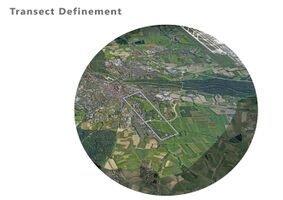
Location and scope
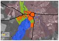
You can edit this map with the map editor
Water as a natural system
Geomorphology, typologies and dynamics of water areas
Tollense Lake in Wider Water System
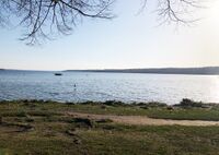
Tollense Lake is located Southwest of the city of Neubrandenburg, Mecklenburg-Western Pomerania, Germany. It has a length of 11 Km and a width of 2.5 m. The Tollense Lake has an area of 17.350 km2 and a depth of 34 m and it lies in an ice age tunnel valley. It is well-known for family spot holidays caused it rated as good quality of water, which means people are allowed to swim in the Lake. Tollense Lake is a very important water area due to its connectivity. It connects to the Tollense River which is the right tributary of the Peene river. From Peene River the river flows to Szczecin Lagoon and Achterwasser, Achterwasser has direct connectivity to the Baltic Sea. Towards Southwest of Tollense Lake, there is a village called Blumenholz. In Blummenholz, Mürzsee is the beginning of upstream of Tollense River. From Mürzsee, a river called Zimmenbach flows into Lieps Lake. From Lieps Lake, Alter Graben River flows from Lieps Lake into Tollense Lake. From Tollense Lake, it has two branches of Oberbach and Ölmühlenbach then both flow into Tollense River. Both branches unite after approximately 1.6 Km.
Catchment Area, Tributaries, Floodplains of Tollense Lake
The Tollense Lake has the longest and most water-rich tributary called Nonnenbach, while the Tollense river has tributaries such as Lindebach. Lindebach is one of the important tributaries due to its flow reaching the Lindetal district, eastern of Neubrandenburg. Another important tributaries is Datze river on the North of Neubrandenburg, Torneybach, gold Bach, Großer Landgraber and Augraben river that are near to Demmin (the end of Tollense River). According to the Geoportal website of Mecklenburg Vorpommern, the floodplains of Tollense Lake and Tollense River are mapped mostly adjacent to part of the built area of the city. The catchment area is shown in the picture below.
Dynamics of Tollense Lake
In 1900, there was 10,500 inhabitant in Neubrandenburg. It grew to 30,449 inhabitants in 1958. As the picture below, the built area was dense near to inner ring of the city, while the green area was dominated around Tollense Lake. In 1991, the built area was developed into the Northeast of Tollense Lake. Presently, the built area has grown into the East and the Northwest of Tollense Lake. In summary, the South, Southeast, and Southwest area of Tollense Lake are still dominated by green areas. The Tollense Lake was formed during the last Ice Age, 15.000 years ago or more than Vistula Ice Age. During Ice Age, the landscape was chains of hills, sand areas, numerous streams, and smaller lakes. Tollense Lake is derived from the Slavic "dolenzia” which means Lowland. The landscape area of Tollense Lake has been known as a glacier tongue basin over a longer period of time. The Tollense Lake is famous for a family holiday spot. There are facilities around the lake that responded to the modern needs of citizens and tourists, the facilities such as passenger shipping, restaurants, cafes, cycling route, and areas for swimming have currently existed.
There was no flood event as recorded around Tollense Lake and Tollense River. However, there is a potential risk of flooding that is mapped below. The water level of this area is rated from Normal to High, and has not reached a warning level.
In Neubrandenburg, we mostly find water canals that originate from Tollense Lake, which creates a harmonious water system that is connected and refreshing. Water in Neubrandenburg comes mainly from the Tollense River, a fresh mixture of various sea and freshwater sources, in the landscaping area, the Tollense supplies the water canals all the necessities for agricultural production and offers opportunities for new agricultural experiments, thus playing a key role in shaping the environment by establishing a dominant river valley that connects the entire city of Neubrandenburg with its water sources.
Water as a living space
Habitats in and along the Tollense Lake
In and along this water area, we see a diversity of plant species and different organisms.
Among the available plant species the following can be mentioned: Downy birch, horse and sweet chestnut, Juniper, European Larch, Juniper, Black Locust, European Wild Apple, Cherry, Elm, European Beech, Ash, Hazel, Spruce, Alder, Pine tree, Willow, Mursh Marigold, Marine plants(like Elodea Canadensis ) and etc.
Respecting the animals in this area, we can mention the diversity of fish ( like European Perch, common Rudd, Vimba Bream, Blicca Bjoerkna and Trout), waterfowl, frogs, and between trees we can see, squirrels, rabbits, foxes, boars, etc., which are easily visible to visitors and residents.
Waterfowl at Tollense lake and adjacent waters:
Winter visitors:singing swan, white swan, bean geese, lesser swan, goosander, lesser scoter, common scoter, white-fronted goose.
Breeding birds:Great crested grebe, mallard, goldeneye, coot, moorhen, gadwall, cormorant, mute swan, pond warbler, great reed warbler, pochard, tufted duck, pochard, white-tailed eagle, osprey, kingfisher, laughing gull, mew gull, herring gull, Egyptian goose, greylag goose.
-
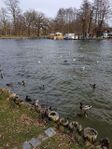 The varied waterfowl of Tollense lake
 -
 European Perch in the Tollense lake
 -
 Green space and trees near the water area


Water quality of Tollense Lake
Tollense river is blessed with factors that nurture the water quality like forest areas, agricultural lands, artificial weirs that controls water balance, suitable temperature, and biodiversity.
•Role of agricultural lands and forests
From the literature study examining various land maps, it is evident that many parts of the Tollense river have numerous forest and agricultural lands along the river. The presence of this dense vegetation nearby increases the oxygen content in the river body. Freshwater sediments release phosphorus in a dissolved form that can be readily taken up by aquatic plants which are helpful to generate oxygen quantity in the water. The organic particles released by the farmlands near the river basin are also good resources for freshwater biodiversity. But on the other hand, Germany published its most recent report on nitrate pollution of waters (“Nitratbericht 2016”, for the monitoring period up to and including 2014), in line with the obligations under the EU Nitrates Directive.
•Role of biodiversity
Varieties of aquatic plants present in Tollense river can use nutrients that would otherwise be used by algae, thereby increasing water clarity. They can soak up pollutants from contaminated water. Underwater and emergent plants can also protect shorelines from erosion due to wave action or currents. A diverse healthy native plant community resists invasion by non-native noxious aquatic weeds such as Eurasian watermilfoil which can be a threat to the water quality. Some plant species filter the unnecessary particles from the flowing water hence improving the turbidity. Fecal deposits of fishes and other species in the surroundings like squirrels, boars, frogs, and birds can manure the aquatic plants that help to cleanse the water.
•Role of temperature
According to studies the water temperature that holds a good amount of dissolved oxygen content is considered from 32 to 86 degrees Fahrenheit. Observing the data of average weather in Neubrandenburg, the temperature reading indicated the satisfactory result from the month March to November as it benefits for the factors for water qualities like; Dissolved oxygen levels(The solubility of oxygen decreases as water temperature increases.) and the Water density and stratification (Water is most dense at 39 degrees Fahrenheit. Differences in water temperature and density between layers of water in a lake leads to stratification and seasonal turnover.)
•Role of artificial structures
Tollense river is equipped with two weirs named Osten and Tückhude to regulate the river flow. The artificial drainage is applied to lower the GW level for agricultural use, especially in the spring months, and accelerates the flow and transport of nutrients in the catchment. The water balance was performed for the whole calibration period and additionally for each hydrological year (Oct 1st to Sept 30th of the following year in Germany). Overall balance is rated as good. The results indicated that groundwater is the main contributor to the surface flows during low rainfall or partial drought periods and balance sewage discharges in the Tollense river catchment.(Muhammad Waseem,Frauke Kachholz et.al ,2020)
•Visual study
From the visual study near Tollense lake, the water appeared as clear enough to see the underwater fishes along with their aquatic habitats and clean enough for the people to use it for swimming and have other recreational activities. Currently, there is no sign of waste disposal or other water polluting activities near the Tollense lake or its surroundings.
-
 Bank of the lake
 -
 Water in Oberbach near the recreational area
 -
 Water in Ölmühlenbach and its surroundings


Areas that are still natural,urbanised/artificial
The significant changes in the areas around are the growth of population and depletion of forest and farmland mainly toward the north-western side of the lake. The addition of recreational spaces and landscape activities serves the tourist attraction to the Tollensesee. Among the artificial structures like bridges, pathways, playgrounds, cemetery, restaurants and fish ladder, boat club on the Oberbach, and the Fisherman's house are tourist attractions.
Fish ladder
A fish ladder, also known as a fishway, fish pass, or fish steps, is a structure on or around artificial and natural barriers (such as dams, locks, and waterfalls) to facilitate diadromous fish's natural migration as well as the movement of potamodromous species. Most fishways enable fish to pass around the barriers by swimming and leaping up a series of relatively low steps (hence the term ladder) into the waters on the other side. The velocity of water falling over the steps has to be great enough to attract the fish to the ladder, but it cannot be so great that it washes fish back downstream or exhausts them to the point of inability to continue their journey upriver.
Fisherman's house on the fishing island in Lake Tollense
The island in the southern part of Lake Tollense in Mecklenburg-Western Pomerania can already look back on a long history, the listed fisherman's house tells of this only the last section of the dwelling of the fishermen since the 18th century, which is still visible today. In addition to the authentic experience of the historical development of this region, nature conservation also plays an important role. If a long-term conservation perspective is to be developed for the building, which has been vacant for more than 20 years, a compromise must be sought, which will certainly only be found with mutual understanding and constructive dialogue, and a responsible owner. According to the council minutes of the city of Neubrandenburg from 1729, the proposal to build a new house on the fishing island in the southern Tollensesee can be found. The construction is decided and carried out by Zimmermann Tröger. Fishing on Lake Tollense played a decisive role in the nutrition of the population for a long time, the island served as a shelter and refuge for the fishermen in GDR times. The two-story and at the core baroque half-timbered building with splet roof has a wide central hallway with a brick stove and allows its structure according to the comparison to the so-called Ernhäuser (Middle German cross-floor houses).
The building is still owned by the city of Neubrandenburg – probably one of the oldest municipally-owned residential buildings in the country. After the last backup was carried out in 2006 as part of an AB measure, the stock is now, 14 years later, acutely endangered again by the progressive decline and long vacancy favored in a remote situation. Currently, the implementation of emergency security with the financial support of the State Office for Culture and Monument Conservation Mecklenburg-Vorpommern is planned.
-
 The fishermas's island
 -
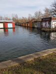 Boat club
 -
 Fish ladder


The permeability for fish or blockage by artificial elements
The presence of different types of fish in lakes and rivers is always one of the beauties of a water area that increases its spatial value. It is necessary to study the obstacles in the movement of fish along rivers, canals, and lakes. Therefore, it is very important to pay attention to this issue in Tollensesee(lake) and its canals which branch into Oberbach and Ölmühenbuch creeks. So, in this section, this issue can be considered in the three main sections of Tollense Lake, Oberbach, and Ölmühenbach creeks.
Tollense Lake
As the largest water basin, has favorable conditions for the movement and life of fish, and there is no artificial barrier that blocks the movement of fish. Even though it is widely used by visitors and used for recreational and sports purposes, the fish can still be clearly seen near the shore.
Ölmühenbach creek
Evaluation of the Ölmühenbach shows that the number of fish is less than near the shore, which is normal due to the decrease in water volume, but in the middle of the canal, due to the existence of a bridge structure that has changed the height by several meters, installing a fishway will keep the proper condition for the movement of fish, which is ecologically necessary. As a result, it can be said that the movement cycle of fish is preserved.
Oberbach creek
In the case of the Oberbach, we see different conditions. And the presence of fish and their movement continues to the intersection of Rostocker Street, and this movement of fish is possible to this point. But from this point toward Tollense river, the existence of overpass bridge, the structure of it and waterfall changes height by around 4 meters and lack of a fish-ladder, cause a blockage in the movement of fish in this point. As a result, it is not possible for fish to proceed along this creek, which has created adverse conditions.
-
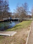 Ölmühenbach creek
 -
 The fish-ladder in the Ölmühenbach creek
 -
 A blockage in the Oberbach creek


Blue and Green Infrastructure
These infrastructures around Tollensesee lake area are impressively well preserved and represented by a variety of green/blue elements (artificial/ natural) which seems not likely to significantly change or disappear in the nearest future.
For the Blue Infrastructure
Neubrandenburg is located in the north part of Lake Tollensesee and also the river Tollense that spread in different canals around the city. The lake in Neubrandenburg in Mecklenburg-Vorpommern, Germany. The lake Tollense is a lake in the northeastern part of the city. The main water bodies are the Lieps Channel, three brooks, the Krickower Bach and Nonnenbach in the southern part of the lake, and also the Gaetenbach in the north> The Olmuhlenbah and the Oberbach in Neubrandenburg. It has an elevation of 14.8 m with an approximate area of 17 km². The lake is 10.4 km long and about 1.5 to 2.5 km wide. Lake Tollensesee has a low flood risk, also the ESG Risk Index is low. Water stress is low-medium, Tollensesee lake has a good quality of drinking water and High level of wastewater treatment but it has drought medium-high risk. Coastal Eutrophication Potential and drought risk is medium-high.
For the Green Infrastructure
Neubrandenburg Tollensesee Lake is surrounded by a green surface that preserves the lake from the city life within the lake the surface is 10,440 hectares, in and around this water area, there is a diversity of plant species and different organism.
For the Gray Infrastructure
Neubrandenburg possesses s strong urban development that is not well related to the Tollensesee, buildings, houses, bridges, streets. All those daily life elements for city development do not relate spatially with the lake, however, they do not affect the constant growth of the city in the near future.
- Are these likely to change/disappear?
Blue
Neubrandenburg's blue infrastructure has a well-preserved lake and river and not likely to disappear in the nearest future. Here are some reasons • The water bodies in Neubrandenburg Increased aesthetic and amenity values of landscape and increased eco-tourism • Improved water regulation and surface runoff and protection from flooding • Wetlands, grassed areas, and urban forests around the lake reduce the risk of flooding, sewage overflow, and clean water contamination.
Green
The green is well preserved and not likely to disappear • Neubrandenburg around the Tollensesse Lake the Greenways and greenbelts are corridors of undeveloped land and parks of rural land that are surrounding the lake and the city. • The pedestrians and bridges are structures that connect two areas of nature and allow wildlife to travel across nor very signi¬cant barriers, such as roads, human-made canals • Urban elements, such as parks, gardens, yards, sports pitches, urban ponds, and canals do not affect the cleanliness of the lake • Public Park, pathways, playing ¬fields, cycle paths, and jogging tracks that encourage outdoor activity and promote good physical health.


Water as a cultural space
Land use and water
- Description in particular of the historical evolution of land use pattern, with use of historical maps.
Neubrandenburg city history starts from 1170. Since date of it’s birth Neubrandenburg suffered from huge fires: 1614, 1676, 1737, 1945 and plague epidemic, this factors effected on city development and lands use. In 1708 Neubrandenburg became something like capital of district that also can be considered as huge push for city development. In 1804 was built first cemetery outside the wall. By 1900 were built 316 houses outside the wall and started more intensive urban development of north and east districts of the Neubrandenburg city behind the wall. So before 20 century main pattern of land use was settlement with natural and agricultural areas. But after 1939 Neubrandenbug got military use districts: camp for prisoners of war in 1939, torpedo experimental station on Lake Tollensesee in 1941, by 1943 was built women’s concentration camp. In 1945 city center was destroyed by fire. And military districts stoped functionearing. In 1953 Neubrandenburg becomes the district capital. To conclude, by now land use patterns of Neubrandenburg never changed significantly: settlements, agriculture and natural areas, exemption in 20 century military area appeared and disappeared (turned into infrastructure).
- Description of evolution, status quo and driving forces, is the land use likely to change? Why is that?.
City grew significantly since 20 century, our working site in Neubrandenburg on which we focus on now consists of: residential area, commercial area, mixed-use area, commercial area, public facilities, green area, water catchment zone and sewage treatment zone. Main driving forces of our working site in Neubrandnburg are: heritage, recreation, tourism, nature-conservation and education. Neubrandenburg saved best defensive medieval wall with gates and Marienkirche (St. Mary's Church) built in 1298, natura conservation lows protected all green spaces and lake from changes and pollution. Heritage and natura attracts tourists to Neubrandenburg and city government focuses on development of tourism. According to this information land use is not likely to change significantly in the nearest future.
-
 Land Use around Tollense Lake
 -
 Existing Buildings 1953
 -
 Existing Buildings 1991
 -
 Existing Buildings 2020


Cultural and spatial typologies of water areas
spatial patterns
The study of spatial patterns of water in the areas referred to as water areas is one of the factors that is considered as an important factor in understanding the history of formation and the type of form of these areas. In the case of the city of Neubrandenburg, this study is about the historical part of the city (Altstadt) related to the past of this city, which today has no trace and presence of water in this part. We can easily detect the presence of a large canal around the historic part of the city in a large circular form. In this section of Neubrandenburg city, there is a fort and a wall around the incipient city that water canals in front of this wall and around the city as a protective factor of the city can be a spatial pattern of that existed in many medieval cities. Of course, as it was said,today, due to the progress of civilization and urbanization, this need and space pattern has practically lost its usefulness. But in the areas closer to the lake, there are canals that connect to the lake. In addition, by some of these canals a variety of activities such as recreational activities. These areas can be considered as the result of human taming of the water supplies in struggle for living in this water area along the lake.
-
 Circular water canal created as a protective implement around the old city.(current downtown)

The role of water areas within the overall urban morphology
The lake was formed during the last ice age, in the last 15,000 years of the Vistula Cold Age, and the subsequent warming phase (ice-free period for about 10,000 years), hill chains, sander areas, numerous streams, and smaller lakes are particularly striking elements of this ice age landscape.
The first Christian monks in the area were Premonstratensian in Broda Abbey, a monastery at the shore (about 1240). The foundation of the city known as Neubrandenburg took place in 1248 when the Margrave of Brandenburg decided to build a settlement in the northern part of his fief, naming it after the older city of Brandenburg further south. In 1292, the city and the surrounding area became part of Mecklenburg.
The name of the lake derives from the Slavic "dolenzia" (low point). The name of the lake derives from the Slavic "dolenzia" (low point). The abundance of fish has attracted the Slavic tribes for many centuries. There are also cultural and social activities around the lake like education centers, tourist attractions, economical activities. From the available maps, the growth of population around the lake is not significant when compared to many other cities. Reasons for the population growth away from the lake could be protected forests, active agriculture, road networks, transportation facilities, and also possibilities of national calamities.
Sacred spaces and heritage
- Fischer Island
Fisher Island is a small island located in the Southwest of Tollense Lake, in front of the city of Penzlin. The island has 150 m in length, 40 m wide, and currently covered by vegetation. In the middle of the island, a fishing hut was built in 1729 and still used in 1970 by fishermen who spent a night. The island was believed to be a center of the Slavic tribe Veleti-Rethra. In 1969, the Archeologist found a figure of Lel and Polel. It is a cult of twin deities of Slavic mythology. In 1977, Hartmut Boeck, a German archaeologist discovered a 40m x 14m rectangular place in the Northeastern Island. In 1905, an excavation by Gustav Oesten found pieces of charcoal and ceramic shells in that place, it indicates a settlement of Slavic worship. It is believed an island is a place of Rethra, the main town, political center, major worship center of Slavic Redarians (one of Lutician tribes)
- Belvedere
Belvedere is located on the North shore of Tollense Lake. In 1775 the Duke of Mecklenburg-Strelitz, Adolf Friedrich IV. built a summer house on a hill. Until then, it was torn down. However, in 1823 grand duke Marie built a summer house at this place in the form of a Greek temple. The house was designed by Wilhelm Buttel. In 1934 Belvedere is converted into a memorial for the dead soldiers of the First World War from Mecklenburg-Strelitz by the architect Heinrich Tessenow. In 1995 the building was restored as an open temple.
- Amtshaus Broda
Amthaus Broda is one of the oldest buildings in Neubrandenburg. A monastery of the Premonstratensian friars was built in In founded around 1170. The construction took time in 1230 and 1240. It is later converted into an official residence Broda with a manorial economy. In the 17 century, this medieval building was almost collapsed. In 20 century, Amthouse Broda was restored as a residential and office building. In 2004 it has been functioned as a guesthouse for International scientists by Hochschule Neubrandenburg.
- The Alter Friedhof
The cemetery of Alter Friedhof is located at the Tollense Lake at Seestrasse, it is a quiet and also a hidden area where the graves are positionned fronting the Tollense lake at the playground directly in front of it called the open Seeperle playground where families get together and play with their kids. The graves have recently been renewed, located within a wide green space with tall trees who seem like they’re protecting the entire area. This sacred place presents its self also by paying respects to the dead of the victims of the world war 2 which has had major and dire effects on the four gated city of Neubrandenburg in which many souls were sadly either sacrificed or murdered in the infamous year of 1945, this space has a very high value, it is considered to be a silent highly valuable sacred space at the Tollense Lake.
Visual appearance and landscape narrative
Essential elements for the landscape character
The Tollense Lake and its surroundings is characterized by a diverse and natural landscape. Beech and oak forests lie to all sides of the water and build a great conservation area. Grasslands and reeds add to a more varied appearance and offer suitable spaces for protected biotopes. The different elements extend over a hilly landscape and create a picturesque view. The lake itself offers wide and open views and the flat banks display its crystal-clear water.
The elementes that have been painted or illustrated are :
• Tollense River originating from Tollense lake in Neubrandenburg towards its downstream end in Demmin, and land use in Tollese river catchment from Klempenow to Demmin
• The Neubrandenburg city fortification is “the most completely preserved example of a medieval city fortification in the brick building area” About 2,300 meters in length, the medieval city wall up to seven meters in height still completely encloses the old city center. Embedded in the almost circular wall ring are four outstanding late Gothic city gates from the 13th to 15th centuries (Friedländer Tor , Stargarder Tor , Treptower Tor and Neues Tor), numerous Wiekhäuser (guard houses) and the Fangelturm, due to the wall and brick gates Neubrandenburg possesses the nickname “city of four gates”.
• Also the main parish church of St. Marien , consecrated in 1298, renovated by Friedrich Wilhelm Buttel after several fires in the 19th century , burned down in World War II and converted into a concert hall from the 1970s to 2001, is now internationally renowned as a concert church, as well as the Franciscan monastery with St. Johannes monastery church.
• The four-wheel mill, which has been home to several dining establishments since it was closed in the 1990s and subsequent renovations.
• The chapel of St. George from the 14th century.
Paintings of the landscape
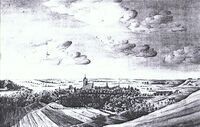
Carl Gotthold Heinrich Arndt: Neubrandenburg, 1775
Carl Gotthold was a German Evangelical Lutheran clergyman and provost at Ratzeburg Cathedral. The painter Carl Wilhelm Götzloff, captured by his enthusiasm for Gothic, composed his winter landscape with a Gothic church from 1821 based on the model of his teacher Caspar David Friedrich. In a review of the picture it was said: "Like this he seems to be fleeing beautiful leafy trees, clinging to coniferous wood, snowstorms, churchyard, moonlight, etc."
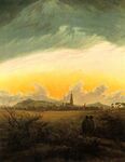
Neubrandenburg by Caspar David Friedrich
Caspar David Friedrich: Neubrandenburg, 1816 and Caspar David Friedrich: Burning Neubrandenburg, around 1835
The paintings of Neubrandenburg by Caspar David Friedrich who was a German painter, graphic artist and draftsman. Today he is considered to be one of the most important artists of early German romanticism who knew the city mainly for the reason of his parents coming from this city. In the main works of Friedrich the break with the traditions of the Landscape painting of Baroque and Classicism completed. The canon of themes and motifs in these pictures preferably combines landscape and religion into allegories of loneliness, death, ideas of the afterlife and hopes of salvation. Friedrich's conception of the world and himself, which is characterized by melancholy, is seen as exemplary for the image of artists in the Romantic eraseen. The main sites in this paint are the tower of St. Mary's Church enriched with a Gothic spire and the majestic low mountain range or the barrow in the foreground come into the picture. The dawn is just breaking behind the black silhouette of the city, which cannot be seen from the northeastern location. In addition, there is the cosmic sky with its swirls of clouds and the cloud fingers that stretch upwards and glow yellow at the edges.
Hans Schleich
Hans Schleich was a german painter who lived from 1834 to 1912. He was a landscape and marine painter. His depiction of the Tollense Lake from 1912 creates an idyllic, calm and sheltered atmosphere. The muted colours vary from blue to green-brown and have a soothing effect. The painting highlights the essential elements of the landscape: trees, shrubs, the panorama and the water.
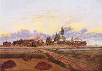
Heinrich Stoll
Heinrich Stoll was a successful german artist who was born in Neubrandenburg in 1822. He worked as a painter and restorer. His painting from 1840 shows and overview of Neubrandenburg and the Tollense Lake. In this depiction the viewer can especially see the hilly and diverse landscape. Meadows and fields surround the city and lake with its dense forest areas.
-
 Carl Gotthold Heinrich Arndt, Neubrandenburg, 1775
 -
 Caspar David Friedrich, Neubrandenburg, 1816
 -
 Caspar David Friedrich, Brennendes Neubrandenburg, etwa 1835
 -
 Hans Schleich, Tollensesee, 1912
 -
 Heinrich Stoll, Neubrandenburg, 1840


Water and People
Accessibility and usability
Accessibility and usability
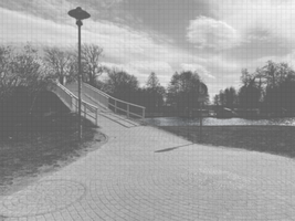
The Tollense lake has in general a high rate of accessibility and usability. Around the lake there are pathways and roads almost without interruption right at the shore of the lake. A lot of footbridges or landing stages as well as numerous lookout towers offer a better viewpoint. There are several beaches, playgrounds, and car parks. Canoes and pedal-boats can be rented. In the southeast, where the village Klein Nemerow lies, the accessibility and usability is a little bit limited because of private houses and gardens. The canals in Neubrandenburg can also widely be accessed and used very easily. The Tollense canal is partly inaccessible because of private property.
The spaces and the people
The Tollense Lake focuses on water as the key element to gather all social groups towards it, it is an attractive pole where the visual and the physical connect within the multifunctional spaces of the water area, such as the bridge, where the youth gather to sit as a group, talk, laugh, drink and party, the culture park is as well a main space where families and friends walk and jog, some accompanied by pets, others feed pigeons and ducks, each space is used in creative fashion where nature and fluidity meet. These public spaces are what make the water area a huge attraction to the people of neubrandenburg, to visitors as well, international students use the lake also to get to know each other. The water area acts as a big platform where several public areas meet to make a more stable connection to nature, water and the city.
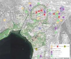
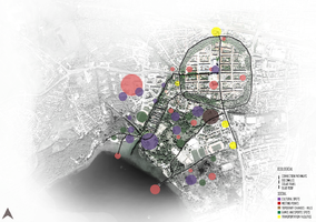
Community Mapping
- Social groups : Tollense lake serves as a vast platform for different ages of people such as kids, teenagers, adults, and senior citizens to engage in recreational and water sport activities surrounding the lake. The presence of certain activities and attraction spots near the lake, entice the tourist as well as the families and elderly people from the nearby residence. Students from the University of Neubrandenburg and other educational institutions find the lakeside surroundings an ideal place to gather or party. The density of the workers from the factory located on the southeast side of the lake is visible around the factory perimeter.
- Local stakeholder groups : Within the perimeter of the Tollenese lakeside to the city, there are a around 7 churches with the closest proximity to the lake which are distributed from the northwest to northeast side of the city closer to the residential parts. A few community centers including event venues and retirement community are present over the city for diverse occasions along with various people. Certain retail shops are located in the inner city and on the east side of the city.
- External stakeholder groups : Local authorities such as government service units and political party offices representing the political bodies are located in different parts of the city premises. In addition to this several care services such as foster care, nursing units, medical clinic, home health care, and elderly care services are also present distinctly over the city areas.
-
 Social groups
 -
 Local and external stakeholder groups


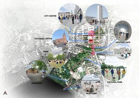
Possible Futures
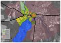
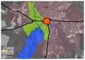
The ecological goal is determined because of the flood risk chance around Tollense River, City Center according to Geodata portal Mecklenburg-Vorpommern. Another issue is regarding water scarcity in Neubrandenburg. It is predicted that the water balance of Neubrandenburg will be negative in the next 50 years, based on Potsdam-Institut für Klimafolgenforschung. Therefore, The ecological goal for the Tollense Lake area (lake and river) is expected.
The social goal has purposes to deal with social issues such as a gap between generations, less interaction of groups in Kulturpark in front of Tollense Lake. In the historical city center, people usually do not feel the presence of Tollense Lake, even though Tollense Lake has existed older than the historical city center. Therefore we aim to introduce the presence of water by creating bioswales. Another issue, people have difficulty navigating from the historical city center to Kulturpark, Tollense Lake.
-
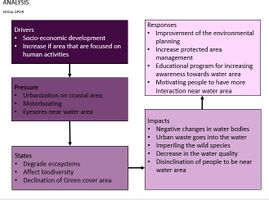 In the field of social analysis, the uncontrolled growth of cities as the most important factor has negative effects on water areas.These negative effects reduce the quality of these areas.These negative effects are visible in various sectors such as water areas, affecting the lives of people and the lives of animals around water areas.Of course, as seen in the diagram, solutions to deal with these negative effects are considered.
 -
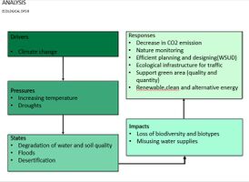 In the field of ecological analysis, climate change has been considered as an influential factor, which causes negative changes in ecosystems and resources.Of course, with practical and accessible solutions, it is possible to promote and preserve the surrounding nature.
 -
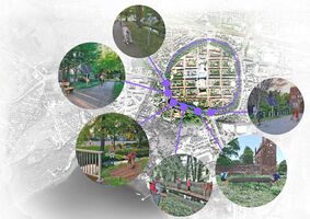
 Process of involving people into improving the Landscape of Tollensesee. Four groups were involved into taking their considerations and ideas to improve the current space around the lake, each group of ten people including students, elderly, adults and kids in different places of Neubrandenburg. These people agree in most of the opinions described in the pictures and activities that should be consider focusing in social and ecological strategies
 -
 On this positive ecological scenario, the green area can function as bioswales in order to increase the rainwater absorption area of Kulturpark. Adding more variety of trees in order to provide house to small animals. The street light based on solar power is applied.
 -
 On this negative scenario of Neubrandenburg in the near areas of the Tollensesee lake there is neither much participation of people into take care of the nature nor activities that involve them into knowing and preserving the landscape of the lake
 -
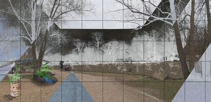 The negative ecological scenario targets the Tollense lake's most obstructive phenomenons, the dry cracked soil of the poluted lake and the toxic waste in the environment are a major factor in the ecological menaces, the citizens’s absence and the lack of frequency to the lake, all due to the climate’s change, ecological carelessness, waste and environmental dangers which reduce the tollense lake’s water quality and the saneness of its landscape.
 -
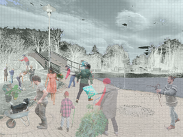 On this positive scenario of Neubrandenburg in the areas of the Tollensesee lake there focusing into the goal of social participation, the idea is having more participation of people and inhabitants of the city in order to preserve with social strategies the good quality of the green spaces and the canals from the lake.
 -
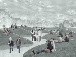 This is positive scenario of Neubrandenburg in the area of the Tollensesee lake and Culture Park. The topography of Culture Park now is quite flat, so design of artificial slopes should work for people both seasons: in summer as place for leasure activities and in winter people could slide downhill.
 -
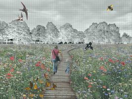 Here is developed positive ecological scenario by installing field of local wild plants in park near Tollensesee lake in Neubrandenburg. Field will increase biodeversity of insects, birds and animals and attract more people to the park.
 -
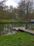
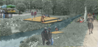
 Shown above is another positive social scenario we imagine for the lake area. A platform is installed nearby the shore, which could be used for events such as concerts or just as a gathering / meeting point for the population. It offers a different viewpoint and the possibility to stay and relax.
 -
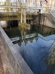
 This ecological scenario is located near the city center. It aims to achieve a better connection of the waterscapes, ideally including the expansion and preservation of biodiversity and giving more space to ecology in this part of the city. It also allows people to experience nature better by creating possibilities like platforms to get in contact with the waterscape.


Collaborative Goal Setting
Our Strategies are focusing on Ecological and Social Goals.
The ecological Goal contains two strategies, Water Sensitive Urban Design (WSUD) approach and Energy Efficiency. WSUD aims to increase the water absorption area of Neubrandenburg by adding green spaces. This can be achieved by designing Bio-swales and agreeing on Green roof proposals for each household in Neubrandenburg. Energy Efficiency is designated to respond to the sustainable energy issue, this is applied by designing solar-powered street furniture.
The social goal has three strategies. First, providing clear access from the historical city center to Kulturpark, Tollense Lake in order to invite more people to the Kulturpark, Tollense Lake. Second, to create a variety of activities in Kulturpark, Tollense Lake such as festival events. Third, to establish a new identity of Neubrandenburg by introducing the historical value of Kulturpark, Tollense Lake. It is possible to create a historical event, an outdoor historical exhibition.
-
 Ecological Collaborative Goal & Involved Community Model
 -
 Social Collaborative Goal & Involved Community Model


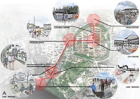
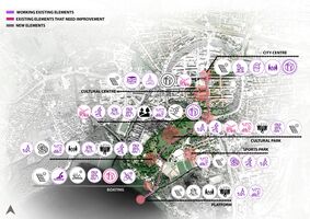
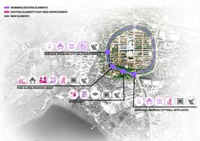
Spatial Strategy and Transect
For purposals, The main idea is focus on two main aspects, Ecological, with strategies such as Connection pathways with reused and new materials, Bioswales, solar panels and Green and blue roofs. The social ideas are focusing on creating cultural spots, meeting points with topography changes, games, sports spots and connecting them with transportation facilities
-
 Purposals
 -
 Goals sketches-1
 -
 Transect -1
 -
 Goals sketches-2
 -
 Transect -2
 -
 Goals sketches-3
 -
 Transect-3


.jpg)


From Theory of Change to Implementation
As a collaborative model shown previously, the ecological goal aims for WSUD and energy efficiency strategies. One of the concepts of WSUD is Bio Swales application. In existing conditions, the city center/ Innenstadt of Neubrandenburg is surrounded by walls. On the outer walls, there is an existing green belt/ green space width of approximately 50 m encircling the city center. The condition of this green belt has quite a steep slope which is a perfect space for bioswales. With the presence of bioswales, when it is raining, the water will fill this area, the presence of water in the city center will be stronger. Ecologically, it will enrich the existing ecosystems, cleaning the polluted rainwater, or as district cooling when it's summertime. In order to achieve this, the mayor necessarily establishes the function of this green belt. The help of landscape architects, engineers, soil consultants is also important to prepare this concept. The academic community may do researches regarding the existing ecosystem.
The social goal in a model before, explains the three strategies to improve and maintain social value in public space near Tollense river and Tollense lake. One of them is providing a variety of activities in Kulturpark, Tollense Lake. In actual conditions, there are teenagers, senior citizens, the family who visit the parks regularly. The seating areas have been a demand as they function as a meeting point, clearly defined waiting space, possibly as a shelter for people. In this case, people are able to choose whether the seating area or just meadows. The seating areas can be designed in the Kulturpark or floating on the lake, this can give a playful experience of the seating areas to people. In order to achieve this, the local people, landscape architects, and management of Kulturpark can work together at one table to decide the seating areas in Kulturpark, Tollense Lake. Another design concept proposal is to provide festivals or any events that make the Kulturpark lively. The events can be cultural, musical, art, exhibitions that involve the local community, or even invite international artists. This can be achieved by the permission of the mayor, and stakeholders that deal with the Kulturpark.
References
- Arnstein, S. R. (2019). Building A Ladder of Citizen Participation: Citizen Participation, and Model Cities. Clemson: Taylor Francis.
- Hofferbert, S., Cahalane, M., & Finnegan, P. (2015). Gamification as an Architecture of Participation: An Investigation of an Innovation Maker community. Sidney: AIS Electronic Library.
- Kay, A. C. (2011). Ignorance Is Bliss When it Comes to Challenging Social Issues. Ontario: Duke University.
- Landscape Institute (2013). Green Infrastructure: Connected and Multifunctional Landscapes. Position statement
- Marschall, S. (1998). Architecture as empowerment: The participatory approach in contemporary architecture in South Africa. Michigan: Transformation: Critical Perspectives on Southern Africa.
- Muhammad Waseem,Frauke Kachholz et.al ,(2020) . Suitability of a Coupled Hydrologic and Hydraulic Model to Simulate Surface Water and Groundwater Hydrology in a Typical North-Eastern Germany Lowland Catchment
- Nitratbericht ,(2016).Germany: nitrate pollution from agricultural sources continues to be considerable; large-scale exceedances of limit values in groundwater
- Sanoff, H. (2000). Community participation methods in design and planning. New york, Chichester, Weinheim, Brisbane, Singapore, Toronto: John Wiley & Sons, Inc.
- Weatherspark,(Cedar Lake Ventures, Inc). Average Weather in Neubrandenburg ,Germany
Process Reflection
All in all, the group worked very well together, divided work equally and communicated in a good way. As a limitation could be seen the overall situation that forced us to do a lot of online work and communication. This made discussions sometimes exhausting and more complicated. However, all the group members contributed their ideas, and we were able to practice taking different perspectives. We also learnt different organizing and designing skills from each other. The Living Lab taught us how to analyse and evaluate waterscapes. It gave us the possibility to gain a much deeper insight into the subject and its complexity. The structure of the lectures and the Wiki gave us a relatively easy access to the topic, and we had the possibility to understand all the different interrelated aspects. We learned to use and read different kinds of maps and to understand the more complex connections of waterscapes. We also gained a better understanding of what it takes to plan and carry out changes to such an extensive issue, especially regarding major challenges like climate change. Also, we collected and found out a lot of information about Neubrandenburg, its history and people, and the rich biodiversity in and around the lake Tollensesee. These information were quite necessary to come up with a concept that includes nature as well as the population. For the next time, it could be considered to form smaller groups, as the communication in big groups can get difficult and might delay the workflow from time to time.