Fondi di Baia WAVE Living Lab 2022: Difference between revisions
Jump to navigation
Jump to search
| Line 92: | Line 92: | ||
== Sacred spaces and heritage == | == Sacred spaces and heritage == | ||
*'' | *''The main elements that hold cultural value are: | ||
-The '''Castle of Baia''', which was built between 1490 and 1493 by the Aragonese and enlarged between the 16th and 18th centuries during the Spanish Viceroyalty, dominates the summit of the promontory that closes the Gulf of Baia to the south. It currently houses the Archaeological Museum of the Phlegraean Fields; the walls of the Castle contain the remains of a grandiose Roman villa, an example of a maritime residential system that rises from the sea for almost a hundred meters to the top of the promontory, where the Roman floors are preserved in excellent condition. The villa was built already in the second century. B.C.'' | |||
<gallery caption=" " widths="200px" heights="150px" perrow="5"> | <gallery caption=" " widths="200px" heights="150px" perrow="5"> | ||
Revision as of 17:00, 19 April 2022
>>>back to working groups overview
| Area | Fondi di Baia | |
| Place | Bacoli | |
| Country | Italy | |
| Topics | Water and Heritage | |
| Authors | Cavallo_Landulfo_Limmatola_Sorrentino_Vodnala | |

| ||
Rationale
- Why do you think this case is relevant? What is your hypothesis considering the landscape challenges?
- Format: 3-4 sentences
Location and scope
You can edit this map with the map editor
Water as a natural system
Geomorphology, typologies and dynamics of water areas
- The Phlegraean Fields, occupy the south-western part of the Campanian plain, have a motto articulated morphology which is due to the superimposition of the deposits of numerous eruptive centers and "calderic" collapses, which occurred in the last 50,000 years
- Campi Flegrei are an area with diffents ancient volcanic crater, some of them are filled with water, as the Fusaro, Averno, Miseno and Lucrino lake, while some of them are filled with vegetation. Slowly, over the centuries, bradyseism has caused much of the ancient evidence to collapse, which has always affected the entire north coast of the Neapolitan area
-
 The lake sistem of the Phlegraean area generated by craters of volcanoes
 -
 Craters of the extinct volcanoes in the Phlegraean area'
 -
 A mosaic of a submerged Roman villa due to dradyseism of the area
 -
 Study of the constraints and risks


Water as a living space
- The good climatic conditions have favored the settlement of Apennine and Mediterranean plant species, which are distributed according to the environmental conditions: this is why in the Phlegraean territory, many plant associations coexist in a small space. The presence of stretches of water favors the formation of a mesophilic flora, typical of the Apennines, while at the highest altitudes it is common to meet Mediterranean vegetation which enjoys the greatest insolarization and aridity
- It has an excellent and bathing water quality according to the analyzes carried out by Arpac Campania
- There are no completely natural areas, there is always a minimal presence of anthropization
-
 Biodiversity of the Baia Area
 -
 How this area is used by the population but preserving their natural characteristics


Blue and Green Infrastructure
- The major potential elements of the area in relation to green and blue infrastructures is certainly the presence of the Fusaro and Miseno lakes that surround the study area, creating an ecological corridor towards the sea together with the large green spaces that characterize the area. As shown in the map, there are also flood and hydraulic risk areas that could lead to a change or disappearance of natural elements
-
 Graphical representations of the Green and Blue infrastructure of the area of Baia
 -
 Fondi di Baia farmhouse
 -
 Fondi di Baia natural park


Water as a cultural space
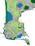
Land use and water
- As shown in the map, the rural landscapes of the study area are characterized not only by agricultural wealth but also by the structure of the agricultural systems. What catches the eye is above all the vastness of the rural component that characterizes the entire area under consideration. Excellent is the production of wines and fruit and vegetables.
- Agricultural plants have their own history that has been handed down over time, and it is certainly a wealth that must be protected and valued, as well as preserved for the new generations
- Due to the phenomenon of bradisimo, as well as to the ever increasing urbanization and natural phenomena such as hydraulic and alluvial risk, the land use may be destined to change
-
 Historical picture of the Castle of Baia with its bay
 -
 Study of the land us subdivided in naturale and rural use
 -
 Study of the accesibility system with rail and road infrastructure


Cultural and spatial typologies of water areas
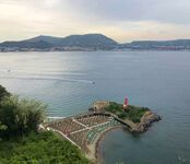
- The urban morphology of our area has never followed a regular path, it's characterized by a sort of widespread urbanization. Probably one of the attractive factors which brought to the first settlements, was the presence of the castle, centre of life during the Aragonese domain. Another important features may have been the presence of the seaside and the near port of Baia. This contributed to generate an economy mainly based on fishing but, thanks to the wide contryside, even based on agricolture. In addition to the sea, another type of water that is very present is the thermal water, very common in all the Phlegraean area
-
 Countryside all around the Castle
 -
 The influence of the port because of its proximity to the Castle


Sacred spaces and heritage
- The main elements that hold cultural value are:
-The Castle of Baia, which was built between 1490 and 1493 by the Aragonese and enlarged between the 16th and 18th centuries during the Spanish Viceroyalty, dominates the summit of the promontory that closes the Gulf of Baia to the south. It currently houses the Archaeological Museum of the Phlegraean Fields; the walls of the Castle contain the remains of a grandiose Roman villa, an example of a maritime residential system that rises from the sea for almost a hundred meters to the top of the promontory, where the Roman floors are preserved in excellent condition. The villa was built already in the second century. B.C.
-
 Cultural, historical and heritage interest areas
 -
 Castle of Baia
 -
 Monumental park of Baia


Visual appearance and landscape narrative
- Which elements are essential for the landscape character?
- Has the landscape been painted or otherwise depicted, when and whom? Which elements are essential?
- Which narratives exist? Who has written about this landscape or depicted it in some way?
- You can add text and images
-
 The Castle of Baia - Carlo Bonavia (1751-1788) oil painting on canvas
 -
 The bridge of Caligola and the gulf of Pozzuoli - Alessandro D'Anna (1743-1810) gouache
 -
 Castle of Baia's hill, 1930
_olio_su_tela.jpg)
_Gouache.jpg)

Water and People
Accessibility and usability
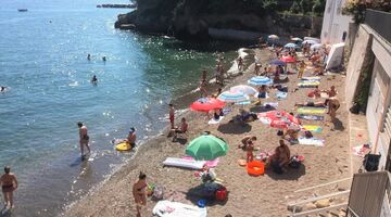
- The water area which are accessible are the Castle of Baia beach and the Villa Ferretti beach; they both have controlled access. There aren't other area where the sea is accessible because of the rocky conformation of the hill, so the spatial obstacles are natural and clearly strong.
- Everyone can enjoy this places but their biggest obstacle is that they can only be reached by sea.
-
 Castle of Baia beach
 -
 Villa Ferretti beach
 -
 Study of the accessibility to the beaches of the area


Community Mapping
What is to be mapped here?
- Social groups from within the community, for example the youth, kids, students, parents, the retired etc. Typically, these groups have specific needs, which you can also make explicit on the map. These people might not be organized in any way, but they are usually present in the context you are observing
- Local stakeholder groups: these groups are organized in one or the other way. They only exist within the community context you are observing. For example: the local community center, local churches, local interest groups, the landowners, small businesses and retailers
- External stakeholder groups are not necessarily present in the environment you are observing, but they may have strong stakes and interests. These can be local authorities, politicians, associations, care services etc.
- For each group, you may identify their needs, objectives, power and capacities
- You may also identify gaps and power conflicts
- Please try to redepict these elements in an integrated way and in relation to your water landscape. What is the relationship between these groups? Are they close or distanced from each other? Who is more powerful? Which voices are hardly heard? Do they have any shared concerns?
-
add a caption
-
add a caption
-
add a caption
Possible Futures
- You can summarize your findings with a SWOT diagram and a DPSI(R) Model
- Link back to the Sustainable Development Goals: Which goals are at risk?
- What is your worst case scenario for this landscape?
- What is your best case scenario for this landscape?
- Present your scenarios in the form of a collage or sketch
- Add text and visuals
-
explain your analysis briefly in the caption
-
explain your worst case scenario briefly in the caption
-
explain your best case scenario briefly in the caption
Collaborative Goal Setting
- Define strategic planning objectives based on the evaluation findings from your analysis
- Ideally, involve the community of your living labs into this process
- Link back to your original targets from section one and the Development Goals
- 150 words text contribution
Spatial Strategy and Transect
- translate your strategic goals into a vision
- develop a spatial translation of your vision
- exemplify your vision in the form of a transect with concrete interventions
- add map(s) and visualizations
-
add caption here
-
add caption here
-
add caption here
-
add caption here
From Theory of Change to Implementation
- For implementing your vision: Which partnerships are needed? Which governance model is required?
- Who needs to act and how? Draw and explain a change/process model/timeline
- Which resources are needed? On which assets can you build?
- add 150 words text and visuals
-
 add caption here
 -
 add caption here


References
- give a full list of the references you have used for your case
Process Reflection
- Reflect in your intercultural and interdisciplinary team on the outcomes of your study
- Which limitations were you facing?
- What have you learnt from each other?
- What did you learn in the Living Labs?
- What would you do differently next time?
- You can also use diagrams/visuals
- 250 words text