The water area in Neubrandenburg is the main attraction of the city. Especially the Tollensesee lake is the main lake in the city which has a rich cultural and strategical history. Since the water area in the city is the main attraction of it, the number of people around the lake is increasing by doing different activities. As an illustration, water sports such as boating, swimming and other outdoor activities such as, volleyball and Frisbee at the beach, walking and cycling around the lake and the cultural park. .And since the goal for this WAVE seminar is maintenance territories in a sustainable way. Especially the places which are relevant to the society and the economy. The Tollensesee considers an important part of everyone who live in Neubrandenburg since most of the activities in the city take place by the lake.
Geomorphology, typologies and dynamics of water areas
Tollense Lake is a lake in Mecklenburg-Western Pomerania, Germany, southwest of the city of Neubrandenburg. It is 11 kilometers long and 2.5 meters wide. Tollense Lake is located in an ice age tunnel valley and has a surface size of 17.350 km2 and a depth of 34 meters.
The environment near the Tollense lake was made up of chains of hills, sand plains, streams, and lakes during the Ice Age. The name Tollense comes from the Slavic word "dolenzia," which meaning "lowland." For a long time, the landscape area around Tollense Lake has been known as a glacier tongue basin. Tollense Lake is a particularly important water region in Neubrandenburg. It joins the Tollense River, a right-hand tributary of the Peene River. The river goes from Peene River to Szczecin Lagoon and Achterwasser, which offers direct access to the Baltic Sea. Blumenholz is a small settlement located southwest of Tollense Lake. Mürzsee is the upstream beginning of the Tollense River in Blummenholz. A river called Zimmenbach feeds into Lieps Lake from Mürzsee. Alter Graben River flows from Lieps Lake to Tollense Lake from Lieps Lake. Oberbach and lmühlenbach are two branches that run into Tollense River from Tollense Lake. After around 1.6 kilometers, both branches come together.
The Nonnenbach stream of the Tollense Lake is the longest and most water-rich, while the Tollense River has tributaries such as Lindebach. Due to its flow reaching the Lindetal district, east of Neubrandenburg, Lindebach is one of the significant tributaries. The Datze river, which flows north of Neubrandenburg, Torneybach, Gold Bach, Großer Landgraber, and Augraben river, all of which are close to Demmin, are important tributaries of Tollense River. The floodplains of Tollense Lake and Tollense River are plotted largely near to part of the city's constructed area, according to Mecklenburg Vorpommern's Geoportal website.
Neubrandenburg had a population of 10,500 people in 1900. In 1958, it had a population of 30,449 people. The built area to the northeast of Tollense Lake was developed in 1991. The constructed area has now expanded to the east and northwest of Tollense Lake. To summarize, green areas still dominate Tollense Lake's south, southeast, and southwest portions. Around the lake, facilities like as passenger boats, restaurants, cafes, a bicycle path, and bathing areas have been built to meet the modern demands of locals and tourists.
No floods have been recorded around Lake Tollensesee and the River Tollense. However, there is a potential risk of flooding because of the climatic change and increase in water level. Water levels in this area have been rated from normal to high and have not yet reached warning levels.
The surroundings and Lake Tollensesee are filled with a variety of plant species and a variety of organisms. Some of the plants species which is seen nearby the lake are Downy birch, horse and sweet chestnut, Juniper, European Larch, Juniper, Black Locust, European Wild Apple, Cherry, Elm, European Beech, Ash, Hazel, Spruce, Alder, Pine tree, Willow, Mursh Marigold, Marine plants(like Elodea Canadensis ) and etc. The lake is also enriched with varieties of habitats European Perch, common Rudd, Vimba Bream, Blicca Bjoerkna, and Trout), waterfowl and frogs. The tourists and travelers can see various types of animals in the south or southeast of the lake like squirrels, rabbits, foxes, boars, etc.
The Tollense River has water quality improvement factors such as forested areas, agricultural land, and man-made dams to regulate water balance, moderate temperatures, and biodiversity. The presence of dense vegetation nearby increases the oxygen content of the river.
Studies have shown that the temperature of water containing large amounts of dissolved oxygen is considered to be between 32 and 86 degrees Fahrenheit. Observing the average weather data for Neubrandenburg, the temperature readings from March to November were satisfactory. Dissolved oxygen levels (oxygen solubility decreases as water temperature increases) and water density and stratification (water density is highest at 39 degrees Fahrenheit. Differences in temperature and water density between the water layers of a lake cause stratification and seasonal exchanges). The various aquatic plants present in the Tollense River can increase the transparency of the water as it can use nutrients that would otherwise be used by algae. They can absorb contaminants from contaminated water. Visual inspection of Lake Tollense showed that the water was clear enough to see aquatic fish and aquatic habitats and clean enough for people to use for swimming and other recreational activities. There are currently no signs of waste disposal or other water polluting activities on or off Lake Tollense.
map the land uses along your water areas: settlements, infrastructure, agriculture, resource extraction, natural areas, energy production...
describe in particular the historical evolution of land use pattern, please make use of historical maps.. In 1804 was built first cemetery outside the wall. By 1900 were built 316 houses outside the wall and started more intensive urban development of north and east districts of the Neubrandenburg city behind the wall. So before 20 century main pattern of land use was settlement with natural and agricultural areas. But after 1939 Neubrandenburg got military use districts: camp for prisoners of war in 1939, torpedo experimental station on Lake Tollensesee in 1941, by 1943 was built women’s concentration camp. In 1945 city center was destroyed by fire. And military districts stopped functionating. In 1953 Neubrandenburg becomes the district capital. Neubrandenburg city history starts from 1170. In 1708 Neubrandenburg became something like capital of district that also can be considered as huge push for city development. To conclude, by now land use patterns of Neubrandenburg never changed significantly: settlements, agriculture and natural areas..
description evolution, status quo and driving forces, is the land use likely to change? Why is that? Heritage, pleasure, tourism, nature-conservation, and education are the main driving elements at our Neubrandnburg construction site. Since the twentieth century, the city has grown dramatically, and our current working site in Neubrandenburg comprises of: residential areas, commercial areas, mixed-use areas, commercial areas, public amenities, green areas, water catchment zones, and sewage treatment zones.
add 1-2 graphical representations to the image gallery, you can add more if you liken
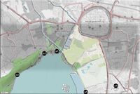
Water Consumption & Land Use around Tollense
Water areas- Settlements, Infrastructure ,Agriculture
Cultural and spatial typologies of water areas
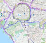
Which spatial patterns have evolved in relation to your water areas?Patterns in space One of the aspects that is regarded to be essential in understanding the history of the development and the kind of shape of these places is the study of spatial patterns of water in the areas referred to as water areas. In the case of Neubrandenburg, this research is focused on the historical section of the city (Altstadt), which is linked to the city's past but currently lacks any evidence of water. The presence of a major canal in a large circular configuration surrounding the old section of the city is plainly discernible.
What is the role of water areas within the overall urban morphology? (approx 200 signs)
The importance of water regions in the overall morphology of cities
Hill chains, sandy regions, many streams, and smaller lakes are particularly noteworthy characteristics of this ice age environment, which was developed during the last ice age, in the final 15,000 years of the Vistula Cold Age, and the succeeding warming phase (ice-free era for around 10,000 years).
Premonstratensian monks from Broda Abbey, a monastery on the coast, were the first Christian monks in the region (about 1240). The city of Neubrandenburg was founded in 1248 by the Margrave of Brandenburg, who decided to build a settlement in the northern part of his fief and named it after the older city of Brandenburg, which was located further south. The city and its environs were annexed by Mecklenburg in 1292.
The Slavic word "dolenzia" was used to name the lake (low point). The Slavic word "dolenzia" was used to name the lake (low point). For generations, Slavic tribes have been drawn to the quantity of fish. Around the lake, there are also educational facilities, tourism attractions, and business operations, among other things. When compared to many other cities, the population growth surrounding the lake appears to be minor, according to accessible maps. Protected woods, active agriculture, road networks, transit amenities, and the possibility of national tragedies might all be contributing factors to population increase distant from the lake.
add 1-2 graphical representations to the image gallery, you can add more if you like
A circular water channel was built around the historic city
Sacred spaces and heritage
Which places/elements hold cultural value and to whom?
Fischer Island
Fischer Island is a small island off the coast of Tollense Lake
Fisher Island is a tiny island off the coast of Penzlin, near the southwest corner of Tollense Lake. The island is 150 meters long, 40 meters broad, and is now vegetated. A fishing cabin was erected in the centre of the island in 1729 and was still used by fishermen who stayed the night in 1970. The Slavic tribe Veleti-Rethra was said to have their headquarters on the island. The Archeologist discovered a figurine of Lel and Polel in 1969. It is a cult dedicated to the Slavic mythology's twin deities. In 1977, a German archaeologist named Hartmut Boeck uncovered a 40m x 14m rectangular area in the Northeastern Island.
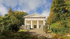
Belvedere
On the north coast of Tollense Lake, you'll find Belvedere.
Adolf Friedrich IV, Duke of Mecklenburg-Strelitz, erected a vacation residence on a hill in 1775. It had been demolished up until that point. Grand Duke Marie, on the other hand, erected a Greek temple-style summer palace here in 1823. Wilhelm Buttel drew out the plans for the residence. The architect Heinrich Tessenow transforms Belvedere into a memorial for the Mecklenburg-Strelitz troops who died in the First World War in 1934. The structure was renovated as an open temple in 1995.
Broda Amtshaus
The Amthaus Broda is one of Neubrandenburg's oldest structures.
In roughly 1170, the Premonstratensian friars erected a monastery in In. In the years 1230 and 1240, the building took a long period. It is eventually turned into a manorial economy official dwelling Broda. This medieval structure was on the verge of collapsing in the 17th century. Amthouse Broda was renovated as a residential and office structure in the twentieth century. Hochschule Neubrandenburg used it as a hostel for international scientists starting in 2004.
The Alter Friedhof
The Alter Friedhof (alter Friedhof) is a place where you
The Alter Friedhof cemetery is located at Seestrasse, near the Tollense Lake. It is a peaceful and secluded place with graves fronting the Tollense Lake and the open Seeperle playground just in front of it, where families meet together and play with their children. The graves have just been restored and are situated in a large green space surrounded by huge trees that appear to protect the entire region.
There is a great deal of accessibility to Tollense Lake. It has a network of pathways and roads that are not frequently interrupted. There are several beaches, playgrounds, a cultural park, and parking lots nearby. In addition to many footbridges, there are also many lookout towers that offer a better view. But there are some restricted areas nearby the lake, because of private houses and gardens. The canals in Neubrandenburg can also be widely accessed and used very effortlessly. The Tollense canal is partly unreachable because of private possessions.
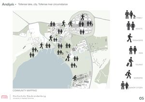
Social groups from within the community, for example the youth, kids, students, parents, the retired etc. Typically, these groups have specific needs, which you can also make explicit on the map. These people might not be organized in any way, but they are usually present in the context you are observing
Local stakeholder groups: these groups are organized in one or the other way. They only exist within the community context you are observing. For example: the local community center, local churches, local interest groups, the landowners, small businesses and retailers
External stakeholder groups are not necessarily present in the environment you are observing, but they may have strong stakes and interests. These can be local authorities, politicians, associations, care services etc.
For each group, you may identify their needs, objectives, power and capacities
You may also identify gaps and power conflicts
Please try to redepict these elements in an integrated way and in relation to your water landscape. What is the relationship between these groups? Are they close or distanced from each other? Who is more powerful? Which voices are hardly heard? Do they have any shared concerns?
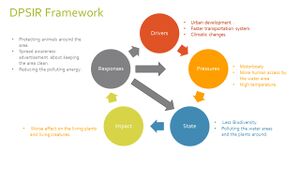
Based on UN sustainable developments goals of Keeping the water clean, it’s predicted that by 2030 the water quality to be improved by reducing pollution, minimising the release of hazardous chemicals in the water and increase the safe reuse of the water. In the case of Tollensesee, there is some proposals to improve the water area. One of them is by reducing the amount of the interactive activities that occur in the water which can cause a lot of damage to the water area. Hence. Spreading awareness among the people would be the very first step into getting a healthy water environment. Using alternative transportation or parallel routes that can’t harm the water area or the creatures in or by the water would be a great sustainable for both the water area and the nature since it reduces the hazardous emissions which reflect positively on the environment and it would be a encouraging step for people to deal and use alternative behaviour towards the water.
climate change and the ignorance about how to deal with the nature elements reflect negatively on the Eco-system and the bio diversity. However, there is always a chance to rescue and change the situation.explain your analysis briefly in the caption

 Water Consumption & Land Use around Tollense
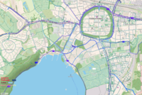 Water areas- Settlements, Infrastructure ,Agriculture

 A circular water channel was built around the historic city

 Tollense and People


 add caption here
 add caption here
