Freising Waterscapes Team 3 2022
>>>back to working groups overview
| Area | please enter the area name here | |
| Place | please enter the town/village name | |
| Country | please enter the country here | |
| Topics | please enter the main topics of your living lab | |
| Author(s) | Please enter your name(s)- optional | |

| ||
Rationale
- Why do you think this case is relevant? What is your hypothesis considering the landscape challenges?
- Format: 3-4 sentences
Location and scope
You can edit this map with the map editor
Water as a natural system
Geomorphology, typologies and dynamics of water areas
Context
The river Moosach is a tributary in the Danube river Basin. The Moosach, with it's source in Unterscheissheim, is a spring water river that flows into the Isar. The Isar connects to the Danube near Deggendorf, close to the German-Chech Republic border. Clearly to see is the small scale of the Moosach river in the bigger context, but also the large impact the water can have on a long stretch of Europe's largest river.
-
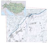 The Moosach in it's context

Water system
The Moosach, especially in and around the city of Freising, has a complex water system. As visible in the figure below, the Moosach has many elements in the river flow, especially compared to the river Isar just south of it. Most of these elements consist of wears to regulate the hight of the water. The complexity is a result of many years of using the Moosach as a energy source for the many mills that used to be in the area. One of these mills is still active in Freising, used as a hydropower plant. This plant can be seen as the red symbol on the map.
-
add a caption
-
add a caption
-
add a caption
Climate change
Just like anywhere in the world, the climate around the Moosach is changing. The trends in the changing of the climate are clearly visible in graphs. The temperature is ever rising, and precipitation is reducing. This will project a future of heat and draught in the area, with peaks of precipitation. This will have a great effect on the ecosystem and human wellbeing in the area as the result of heat stress, draught and flood risks.
-
add a caption
-
add a caption
-
add a caption
Floodings
The river Moosach has a history of floodings, with locals living in flood plains having to evacuate every few years. This problem will, according to the projections of precipitation peaks, only get worse. In the figure below the cause and effect are shown. The waterflow of the Moosach is greatly affected by rainfall in the local area and the ridges of the hills in the north. Due to canalization in the 1930's, the river has been straightened resulting in a fast flow of water. When this fast flowing water flows into the complex water system of Freising, problems arise. Water builds up and is not contained by dykes (like the river Isar). The result is agricultural, and residential area's being flooded with economical cost and the possible loss of human life.
-
add a caption
-
add a caption
-
add a caption
Water as a living space
Water quality
In general, the water quality of the river Moosach is described as good. However, problems with overfertilization and water temperature have arisen. The Moosach has been used and adapted since the 1930 to drain the surrounding Freisinger Moos as agricultural land and as a place for fish farming. This has lead to problems in floodings, but also erosion and overfertilization of the river. This leads to the overpopulation of Macrophytes, water plants that take oxygen away from water fauna. This problem is also getting worse because of the open landscape, were the lack of shade in the river leads to high water temperatures. These temperatures lead to illness in trout species. Fauna also gets hindered by the many elements in the water system.
-
add a caption
-
add a caption
Fauna and flora around the Moosach
The surroundings of the Moosach river is a habitat for many endangered plant -, bird -, and butterfly species. In a large part of the Freisinger Moos the bird habitat is protected. This gets improved by the local use of the area as a drinking water source. Pesticides and chemical fertilization is prohibited here.
-
add a caption
-
add a caption
Blue and Green Infrastructure
On the bigger scale, the importance of the Isar river is clearly visible. Not only is it important on the local level, but also international. The green-blue infrastructure connects the center of Munich with the Danube near the Chech border. This connects it all the way to the Black Sea. Also the green-blue infrastructure of the Amper river is important on the local level, just as the green infrastructure of the hill ridge line. However, this is not connected to the Moosach.
The reason of this, again, goes back to the exploitation of the Moosach and the Freisinger Moos in the 1930's. Although a small part of the Freisinger Moos remains, most of the surroundings are lacking in forest. This can be seen again when looking at the protected area's, where this pattern returns.
-
add a caption
-
add a caption
Water as a cultural space
Land use and water
- map the land uses along your water areas: settlements, infrastructure, agriculture, resource extraction, natural areas, energy production...
- describe in particular the historical evolution of land use pattern, please make use of historical maps
- description evolution, status quo and driving forces, is the land use likely to change? Why is that? (approx 200 signs)
- add 1-2 graphical representations to the image gallery, you can add more if you like
-
add a caption
-
add a caption
-
add a caption
Cultural and spatial typologies of water areas
- Which spatial patterns have evolved in relation to your water areas?
- What is the role of water areas within the overall urban morphology? (approx 200 signs)
- add 1-2 graphical representations to the image gallery, you can add more if you like
-
add a caption
-
add a caption
-
add a caption
Sacred spaces and heritage
- Which places/elements hold cultural value and to whom?
- You may add a map and some images, please also explain in your caption why these elements are valuable
-
add a caption
-
add a caption
-
add a caption
Visual appearance and landscape narrative
- Which elements are essential for the landscape character?
- Has the landscape been painted or otherwise depicted, when and whom? Which elements are essential?
- Which narratives exist? Who has written about this landscape or depicted it in some way?
- You can add text and images
-
add a caption
-
add a caption
-
add a caption
Water and People
Accessibility and usability
- Where are your water areas accessible, and where not? How strong are spatial obstacles preventing access?
- Who is using the spaces and how?
-
add a caption
-
add a caption
Community Mapping
What is to be mapped here?
- Social groups from within the community, for example the youth, kids, students, parents, the retired etc. Typically, these groups have specific needs, which you can also make explicit on the map. These people might not be organized in any way, but they are usually present in the context you are observing
- Local stakeholder groups: these groups are organized in one or the other way. They only exist within the community context you are observing. For example: the local community center, local churches, local interest groups, the landowners, small businesses and retailers
- External stakeholder groups are not necessarily present in the environment you are observing, but they may have strong stakes and interests. These can be local authorities, politicians, associations, care services etc.
- For each group, you may identify their needs, objectives, power and capacities
- You may also identify gaps and power conflicts
- Please try to redepict these elements in an integrated way and in relation to your water landscape. What is the relationship between these groups? Are they close or distanced from each other? Who is more powerful? Which voices are hardly heard? Do they have any shared concerns?
-
add a caption
-
add a caption
-
add a caption
Possible Futures
- You can summarize your findings with a SWOT diagram and a DPSI(R) Model
- Link back to the Sustainable Development Goals: Which goals are at risk?
- What is your worst case scenario for this landscape?
- What is your best case scenario for this landscape?
- Present your scenarios in the form of a collage or sketch
- Add text and visuals
-
explain your analysis briefly in the caption
-
explain your worst case scenario briefly in the caption
-
explain your best case scenario briefly in the caption
Collaborative Goal Setting
- Define strategic planning objectives based on the evaluation findings from your analysis
- Ideally, involve the community of your living labs into this process
- Link back to your original targets from section one and the Development Goals
- 150 words text contribution
Spatial Strategy and Transect
- translate your strategic goals into a vision
- develop a spatial translation of your vision
- exemplify your vision in the form of a transect with concrete interventions
- add map(s) and visualizations
-
add caption here
-
add caption here
-
add caption here
-
add caption here
From Theory of Change to Implementation
- For implementing your vision: Which partnerships are needed? Which governance model is required?
- Who needs to act and how? Draw and explain a change/process model/timeline
- Which resources are needed? On which assets can you build?
- add 150 words text and visuals
-
 add caption here
 -
 add caption here


References
- give a full list of the references you have used for your case
Process Reflection
- Reflect in your intercultural and interdisciplinary team on the outcomes of your study
- Which limitations were you facing?
- What have you learnt from each other?
- What did you learn in the Living Labs?
- What would you do differently next time?
- You can also use diagrams/visuals
- 250 words text