Freising Waterscapes Team 3 2022
>>>back to working groups overview
| Area | River "Moosach" and its surroundings | |
| Place | Freising | |
| Country | Germany | |
| Topics | Analysis and scenario building of a river landscape | |
| Author(s) | The Fluss Floaters:
Kees van Roon, Fabrizio Albion, Gentiane Thaci, Delaram Kouhestani, Nora Buffham | |

| ||
| An artistic depiction of the current state of the Moosach | ||
Rationale
Moosach river is located near München, Bavaria in Germany. The river is a 38 long tributary of Isar river. Moosach characterizes the area of Freising as it flows through the landscape, however due to urbanization and population growth, this changed the course and the flow of the river. Floods could happen causing damage to settlements and the living environment as there is no buffer between these areas. People want to build close to the river in the floodplain to experience the water. Climate change also does not mitigate these flood events, it only increases these effects. All these our relevant issues which need to be solved in order for a better living space.
Location and scope
You can edit this map with the map editor
Water as a natural system
Geomorphology, typologies and dynamics of water areas
Context
The river Moosach is a tributary in the Danube river Basin. The Moosach, with it's source in Unterscheissheim, is a spring water river that flows into the Isar. The Isar connects to the Danube near Deggendorf, close to the German-Chech Republic border. Clearly to see is the small scale of the Moosach river in the bigger context, but also the large impact the water can have on a long stretch of Europe's largest river.
-
 The Moosach in it's context

Water system
The Moosach, especially in and around the city of Freising, has a complex water system. As visible in the figure below, the Moosach has many elements in the river flow, especially compared to the river Isar just south of it. Most of these elements consist of wears to regulate the hight of the water. The complexity is a result of many years of using the Moosach as a energy source for the many mills that used to be in the area. One of these mills is still active in Freising, used as a hydropower plant. This plant can be seen as the red symbol on the map.
-
 Watersystem and fauna/flora in the Moosach

Climate change
Just like anywhere in the world, the climate around the Moosach is changing. The trends in the changing of the climate are clearly visible in graphs. The temperature is ever rising, and precipitation is reducing. This will project a future of heat and draught in the area, with peaks of precipitation. This will have a great effect on the ecosystem and human wellbeing in the area as the result of heat stress, draught and flood risks.
-
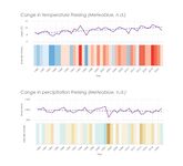 Climate Change in Freising

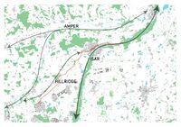
Floodings
The river Moosach has a history of floodings, with locals living in flood plains having to evacuate every few years. This problem will, according to the projections of precipitation peaks, only get worse. In the figure below the cause and effect are shown. The waterflow of the Moosach is greatly affected by rainfall in the local area and the ridges of the hills in the north. Due to canalization in the 1930's, the river has been straightened resulting in a fast flow of water. When this fast flowing water flows into the complex water system of Freising, problems arise. Water builds up and is not contained by dykes (like the river Isar). The result is agricultural, and residential area's being flooded with economical cost and the possible loss of human life.
-
 Flood risk map

Water as a living space
Water quality
In general, the water quality of the river Moosach is described as good. However, problems with overfertilization and water temperature have arisen. The Moosach has been used and adapted since the 1930 to drain the surrounding Freisinger Moos as agricultural land and as a place for fish farming. This has lead to problems in floodings, but also erosion and overfertilization of the river. This leads to the overpopulation of Macrophytes, water plants that take oxygen away from water fauna. This problem is also getting worse because of the open landscape, were the lack of shade in the river leads to high water temperatures. These temperatures lead to illness in trout species. Fauna also gets hindered by the many elements in the water system.
Fauna and flora around the Moosach
The surroundings of the Moosach river is a habitat for many endangered plant -, bird -, and butterfly species. In a large part of the Freisinger Moos the bird habitat is protected. This gets improved by the local use of the area as a drinking water source. Pesticides and chemical fertilization is prohibited here.
-
 Species in the Freisinger Moos

Blue and Green Infrastructure
On the bigger scale, the importance of the Isar river is clearly visible. Not only is it important on the local level, but also international. The green-blue infrastructure connects the center of Munich with the Danube near the Chech border. This connects it all the way to the Black Sea. Also the green-blue infrastructure of the Amper river is important on the local level, just as the green infrastructure of the hill ridge line. However, this is not connected to the Moosach.
The reason of this, again, goes back to the exploitation of the Moosach and the Freisinger Moos in the 1930's. Although a small part of the Freisinger Moos remains, most of the surroundings are lacking in forest. This can be seen again when looking at the protected area's, where this pattern returns.
-
 Green blue infrastructure
 -
 Protected area's


Water as a cultural space
Land use and water
Over the centuries, the waterscape of Moosach river has been considerably altered by human activities, especially with the intensification of agriculture and urbanisation of the region. Today, agricultural land use covers most of the territory and has caused the canalization of the entire river, damaging the natural environment of the Freisinger Moos, the extensive flat mossy area between Freising and Munich. Furthermore, this area is also subject to constant change due to grey infrastructures, from the construction of the Munich-Freising railway in 1858 to the new Westtangente road in January 2022. These constructions are at the same time causes and effects of the expansion of urban areas, especially the Munich metropolitan area. On the contrary, Freising has remained a small compact city for most of its history and only in the last thirty years has it started to expand rapidly, mainly due to the new presence of the International Airport of Munich. It covers a large area in the southeast of Freising and its further expansion is still a possible threat for the territory, along with the continuing demand for housing in the city.
-
 History of the Moosach
 -
 Landuse around the Moosach


Cultural and spatial typologies of water areas
Starting from the open landscape of the Freisinger Moos, the river divides itself into many channels, partly still covered, running through the concrete landscape of Freising. Its canalization from source to mouth has been realized to its use for agriculture, fish farming, hydropower and drinking water.
-
 Spacial analysis Moosach

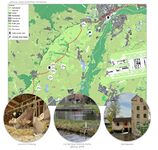
Sacred spaces and heritage
The main cultural values of Freising and its surroundings have been strongly present for centuries, from its famous products, beer and milk, to its identity as a university city. Freising is also known as an important religious center and for its garden culture. These values are clearly visible in the city’s landscape, especially in the presence of churches, notably the Dom St. Korbinian on Dom Hill and the Korbiniansbrünnlein on Weihenstephan Hill. This latter hill is famous for being part of the university campus and for the Weihenstephan Brewery, known as the oldest brewery of the world still open. Along with the historical center, these identity places are commonly used and visited from both locals and tourists alike.
-
 Identities of Moosach
 -
 Monuments around the Moosach


Visual appearance and landscape narrative
Moosach takes part of a special encounter between two different spatial landscapes, from flat to hilly. Mainly due to the presence of the river, it was there that the foundation of the city of Freising began, firstly on the two well-known Dom Hill and Weihenstephan Hill.
In numerous paintings of the Freising landscape the same characters always appear, which are still easily recognizable today. For example, we have identified most of the main historical values in a painting from 1698, where we can see the river, the Freisinger Moos, the compact city of Freising, the historical Weihenstephan garden and the surrounding agricultural fields.
-
 Identities in a 17th century painting

Water and People
Accessibility and usability
The Moosach River flows along with urban spaces, rural spaces, and farms. Out of the city, the edges of the river are natural and there are not many public paths. In urban spaces, the water areas are more accessible by the walking and bike routes along the river. Some transects of the river are covered and because of channelization, it is not easy to touch the water in Freising. Most boundaries of the Moosach River are soft around Freising. But as we get closer to the city, the boundaries are getting more concrete. The interactions between people and the river are limited to countless spaces for sitting or bridges for crossing the river.
The Moosach River is exploited for agriculture, fish farming, energy (hydropower), housing, transportation, and drinking water. The people who use the spaces generally are the internal stakeholders. Additionally, the people that we had interviewed are more locals and students. There is no intensive activity and most of the people’s activities are just for relaxation or while traveling by bike or on their feet. According to the varied social, cultural, and artistic events that we found in Freising during the year, the most important events are held in the center of Freising (Marienplatz) and there is not a lot of connection to the Moosach.
-
 Accesability
 -
 Activities of interviewed people around the Moosach
 -
 Activities and events around the Moosach


Community Mapping
The community is shaped by social groups, local stakeholders groups, and external stakeholder groups. It includes government, media, experts, interest groups, individuals, and associations. Their proportions are different; Conflicting, neutral, and positive relations. For instance, there are conflicting relations between ecologists (expert group) and farmers (interest groups). Active City Freising, TUM Students, and HSWT Students as three Associations have positive relations. In addition, Green Party and Landscape Architects are in a Neutral relationship.
These groups have specific needs, interests, and power. For example, the Green Party with high power needs to expand the protected areas and increase the biodiversity as their goals. It is interested in the plans they can sell to the voters and it contributes to promoting and financing a project that responds to its main political topics.
Rural area locals with low power need better infrastructure. They are interested in deforestation and sustainable agriculture and contribute by collaborating to take measures regarding flood risk management.
-
 Interrest groups
 -
 Community mapping
 -
 Needs and interrests


Possible Futures
Analysing the project area, we used three main frameworks (DPSIR, SWOT, Riskmapping), identifying all the aspects which have to be considered before planning a new scenario. In the waterscape of Moosach, the Sustainable Development Goals which are at risk are mainly the ones threaten by the climate change risks, the flood risks and the growing of the population: water and soil as limited resources, human health, well-being, economic andsocial stability.
-
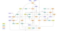 DPSIR of the current state of the Moosach
 -
 SWOT analysis of the Moosach
 -
 Riskmapping the treats


Collaborative Goal Setting
From our analysis of the Moosach river and using the frameworks such as SWOT, DPSIR and risk mapping, lead us to the understanding of the landscape, giving us the tools to see the different risks, impacts and problems. We started with studying the EU and German climate goals to implement these for our future design, aligning them with our 4 main goals: resilient economy, enriched identity, restored nature, suitable living.
Resilient economy:
To achieve this overall goal, we came up with several smaller goals. We would like a better connection between the local economy and global network and a better connectivity with the surroundings by improving and relying more on public railway networks, which reduces carbon fuel emissions. Having a sustainable agriculture (paludi culture) and innovative food production (hydroponics) lead us to a space-efficient landscape and reduced methane and nitrous emissions. Introducing renewable energy (solar panels) to our design reduces emissions in all sectors as well.
Restored nature:
Our main goals are to improve and have more diverse habitats by renaturalization of the Moosach. Returning it to its natural flow and having better water quality, by removing the producers of pollution is important to us. Adding new diverse habitats to the green-blue infrastructure and connecting the Isar and Moosach will give us a green-blue cross-border network. In addition, restoring the Moos is one of our main concepts to be implemented which could absorb the greenhouse gasses.
Enriched identity:
In this section our main focus is not only on enhancing the already existing cultural identity of the landscape and community but also giving back a part of the past identity of Freising: The Moos and Moosach. We improve the accessibility to the Moosach, by adding more activities in the area. Sustainability and innovation as a new identity is also a goal of ours.
Sustainable living:
Our main goals here to have an urban space which is resilient to urban heat island, where people could live close to nature, protected by the airport noise pollution and floods.
-
 Eu and German Climate Goals
 -
 Achieved German Climate Goals
 -
 Main goals


Spatial Strategy and Transect
Vision:
In 2050, the waterscape between Munich and Freising is a place where a trampled nature has the ability to restore itself. Modern technology balances the need for food and space which results in a compact, but integrated landscape without fragmenting it. The population has the unique opportunity to both live in a natural environment and be connected to a metropolis, while living the most sustainable way possible for its time.
Spatial concept:
To translate the vision to a design, a spatial concept has been created. Here a zoning has been given with peatland, settlement, hydroponic farms, closed agriculture and open agriculture. Through this run forest and the rivers. The placement follows the following rules:
- Settlements and hydroponic farms are encased by forest to protect natural area’s
- Peatland is restored, with a free flowing Moosach
- Bands of forest connect green structures
- Around the Isar is closed agriculture with a larger focus on recreation
- The Moosach and Isar are connected by an emergency overflow in case of floodings
-
 Vision: Put the "Moos" back into " Moosach"
 -
 Spatial concept
 -
 Detail of transition from Freising to the open space, river landscape
 -
 Master plan


From Theory of Change to Implementation
Many partnerships and connections are needed to realize our vision. Having the government on our side is an important relation to us, since now the Freising has a green party, our goals could be easily aligned and transform into realizations. Collaborating with department of climate protection alliance and environmental protection and waste management institute would increase our changes. In addition, it is also impossible to achieve our vision without stakeholder participation. According to are transect we mapped out what type of stakeholders we predict would be influenced by our design and how would they react to our ideas in the future of 2050. Three different colors show their relation to our design (in favor, neutral, against). By using this method, we can clearly see a mostly positive response as our main goals align with the stakeholders needs: restoring nature, making a resilient economy, enriching identity and having a sustainable living environment. Involving and compensating stakeholders and having consultations with experts could lead us to a sustainable implementation.
Of course, implementation need resources, which could be achieved by EU funding and various government and regional resources from the Bundesministerium des Innern, für Bau und Heimat and Städtebauförderung von Bund, Ländern und Gemeinden.
In 3Ds and axonometries you can see how some of our implementation would develop in the years.
-
 Renaturalization and connecting Isar and Moosach
 -
 Restoring the Moos
 -
 Stakeholders of our transect and their opinions regarding our design for 2050


-
 Expansion of Freising
 -
 Forest growth
 -
 Development of Hydroponics
 -
 Restoring the Moos
 -
 Renaturalization of the river Moosach


References
- give a full list of the references you have used for your case
Process Reflection
Working with an international and interdisciplinary team brings its benefits and conflicts as well. Since we use different software programs and have different knowledge it led us the opportunity to learn from each other and to see how people interpreter various ideas and how they think. However, cultural differences in work, time and conflict management were our key challenges. Slowly but steadily, we learned how to approach each other and discuss these problems openly, solving and easing them.
Living labs and having the opportunity of lectures from diverse countries gave us a large insight of understanding waterscapes.