Freising Waterscapes Team 4 2022
>>>back to working groups overview
| Area | Moosach River | |
| Place | Upper-Bavaria | |
| Country | Germany | |
| Topics | Moosach Waterscapes | |
| Author(s) | Ana-Cristina Gonzalez, Ayse Dolanbay, Joshua Peterson, Nanna Harðardóttir and Shyam Chaudhari | |
Rationale
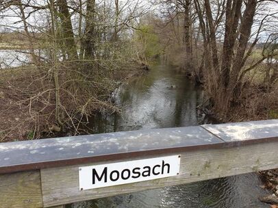
The river Moosach is a tributary river to the Isar river. Moosach runs through the city of Freising in Oberbayern where it splits up to many different branches. The main problems for the Moosach are for example flooding, pollution, lack of visitors, lack of biodiversity and lack of diversity. Heavily modified riverbanks are also a big problem, especially around the city of Freising. In the rural areas, Moosach runs through a lot of agricultural area where riverbank buffers are non-existing in many places and very little diversity is in the landuse. With the following content we want to analyze the river and show a possible future version of improvement.
Location and scopes
Water as a natural system
Geomorphology, typologies and dynamics of water areas
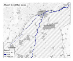
The Munich gravel plain is a 1500 km2 flat area formed during the last ice age. The Alpine glaciers reached down to the Munich area and discharged large amounts of rocks and soil. Today, these borders can be seen clearly around the Freising area, north of Munich city. The river Isar flows down from the Alps and through the plain and has shaped the landscape with its vast floodplains. Isar has many tributary rivers in the area and one of them is Moosach which this project is about. Moosach, Isar and many other rivers are then tributary rivers to the Danube which is the second largest river in Europe.
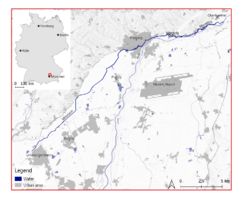
Moosach is a 38 kilometer long river with a “name” starting point around Unterschleißheim north of Munich. This is not the original starting point though. In the Moosach district of Munich, the Moosach river originally started. Through time, the river has been changed by people and is now known as the North Munich canal system. The new origin of the Moosach is now in Oberschleißheim Castle Park, however there it is called Berglbach. It is not until Berglbach reaches the town of Unterschleißheim, where the name changes to Moosach. The river runs for most part from south-west to north-east where it joins the river Isar near the town of Oberhummel. However, about 30% of the Moosach river splits away and joins the river Amper. So in a sense, Moosach is a tributary to two rivers.
After the Moosach runs through Unterschleißheim, it goes through agricultural areas before entering Freising. In Freising the river branches off into several streams near Weihenstephan Berg. After that, most of the streams go into narrow canals or underground pipe systems. Some of these streams then join together again on the eastern side of Freising where it then runs though some natural area where it joins Isar, near the town Oberhummel. Most of the Moosach runs parallel to the northern borders of the Munich gravel plain. North of Moosach, Hügelland landscapes take over. Tertiäres Hügelland is a topography consisting of low rolling hills. The Munich gravel plain has pretty much no topographic features since it's a large flat area. Moosach is a border between two very different topographic landscapes.
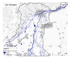
Moosach floodplains have not been identified. However, there is data about Isar floodplains. When Moosach is added to the Isar floodplain system, we can see that after the town of Marzling, east of Freising, Moosach joins Isar’s floodplain system and stays there until those two rivers join.
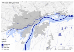
Most floods in this area are a result of heavy rain and because of climate change these floods are becoming more common and more serious. Many structures in the Freising area are in flood hazard zones and with more urbanization this problem is getting bigger. In 2013 a big flood occured in Freising with a lot of property damage.
Water as a living space
Isar Meadows is the home to alluvial forests which are forests of narrow floodplains. They have some of the most species- and biotope-rich areas in Europe. They filter groundwater and include tree species like English Oak that tolerate long periods of flood. They include some rare tree species such as black poplar, white willow and white elm. Other creatures that live in the Isar Meadows are, for example; Forest orchid lady's slipper, beavers, bats, various amphibians like crested newt and agile frog. Bird Species you find there are for example Woodpeckers, Honey Buzzard, Turtle Dove and Oriole
Moor remains are one of the largest fen areas in Bavaria. The ecosystem is linked to other wetlands via the Moosach river. They contain ecosystems such as litter meadows which come from traditional agriculture, but which suffer under intensification. Most common animals there are for example; Beaver, Groppe fish, Southern Damselfly, and Narrow whorl snail
Bird protection of Freisinger Moos is a special protected area/bird sanctuary that is important habitat for meadow-nesting birds and wetland species. Many important bird species seek the biodiversity of the Moos. EU nature law covers this area because of species like the Common Kingfisher and Corncrake
If you look at the water structure mapping of Bavaria rivers from 2017 you can see how they are rated from natural to heavily modified. Heavily modified river landscapes can be found in and around the city of Freising in red color. However, east of Freising near the city of Marzling are blue lines which represent natural riverscapes. This area is a protected floodplain forest. This map can also give an idea about the water quality of the river but where the river landscape is heavily modified the river does not have a natural way to clean itself, therefore those areas can have worse water quality.
Blue and Green Infrastructure
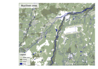
Large forest areas can be found around Isar, however there are large areas that don't have a cohesive forest, just small patches of trees. The main reason for this could be the large amount of agricultural land where the land use is mostly for food production. This also leads to lack of diversity and poor variety of vegetation which is bad for ecosystems. Blue infrastructure is very limited to the rivers and most of the lakes in the area are man-made.
If there is no change in man's behavior regarding vegetation diversity, this can lead to the extinction of many ecosystems.
Water as a cultural space
Land use and water
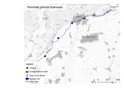
Few fish farms/Aquaculture can be found on the banks of Moosach. These businesses can produce a lot of waste and can be a breeding ground for diseases. If the waste and the diseases get into the natural water system it can have a devastating effect on ecosystems in the area.
In the city of Freising there is a sewage treatment plant but they can have effects on the biotic status of receiving rivers and cause pollution if the plant is not equipped with a proper filtering system. Few hydropower Stations can also be found on the river but they can obstruct fish migration and harm water quality and habitats, even though they installed fish stairs for contribution to the environment.
The riverscape of Moosach has changed a lot throughout the centuries. The first major change to the landscape was in 1858 when a new train station was built in Freising. The new train tracks had a huge impact on the landscape in the sense of being a splitting element. Another huge factor in the change of landscape around Freising is the Munich airport. It has grown bigger and bigger in the past years with traffic networks and settlements growing exponentially.
With all of these new developments the river structure has been affected in a big way. Large parts of the Moosach have been straightened and become heavily modified; this has happened especially after 1938 when Freising development exploded. The reason for this is for example to adapt city development or infrastructure to get larger farmingfields. Or they need more land for infrastructure and the river is in the way, they will just move it somewhere else and it usually becomes unattractive for the urban areas. The result is that the river flow can become much faster and be a bad impact for biodiversity.
Cultural and spatial typologies of water areas
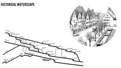
Many different uses of the Moosach have led to the form it has taken today. To disperse water flow during flood is one of those uses but also to distribute water to fight fire, for example the Weihenstephan pump in the 16th century. In the map below you can see how many mills were in Freising. We can imagine that there were a lot of conflicting interests between mills, as changing the flow to suit one mill often disrupted another. But sometimes they did act collectively.
In the illustration is the river on Hauptstraße, a section called Niederbach. This section was actually key to the development of the town. Niederbach was laid out as a ditch around 1300 when the surroundings were mostly moor, and then structures began to be built along it. It was mostly used for cleaning and then it was first covered in places starting around 1760, because it was a health hazard and had an extreme odor. So that was the initial reason for it to be covered, which we are now uncovering. So many of these uses are not relevant, but flooding still is.
Water and People
Accessibility and usability
The Moosach has a mix of accessible and inaccessible areas. There are few recreational areas for people but also untouched areas without human footprint. Some areas that we noticed on our field trip were:
Community Mapping
We are focusing especially on the rural areas outside of Freising. Based on accounts of how cooperation with farms is key to successful implementation of new policies for environmental protection, we hypothesize that the key landscape democracy challenge will be uniting farmers with people in the city of Freising in completing mutually beneficial projects in the Moosach waterscape.
Freising is a middle and working class community that is greatly shaped by its proximity to a large international airport and the city of Munich. The campuses of HSWT and TUM mean there is a proportionally high number of young people.
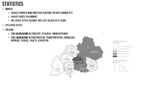
Munich’s growth has put pressures on the real estate market and regional transportation. We wanted to look deeper into how it will grow and what ways this might influence development in the area in the future.
The projected continued growth of Munich will lead to increased spillover into the surrounding areas, including between Unterschleißheim and Freising which encompasses the Moosach. Looking at projected jobs, we can see that industries like manufacturing are not expected to increase, but information and service sectors will. We will use this information to hypothesize about the types of land use we might see expanding in the future around Freising, and how this might change the community of our project area.
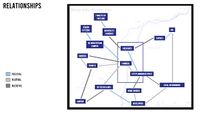
We researched businesses, planning entities, nature groups, and others, and plotted them according to their importance, and then again according to their power.
Possible Futures
- You can summarize your findings with a SWOT diagram and a DPSI(R) Model
- Link back to the Sustainable Development Goals: Which goals are at risk?
- What is your worst case scenario for this landscape?
- What is your best case scenario for this landscape?
- Present your scenarios in the form of a collage or sketch
- Add text and visuals
- Your case your spider diagram or dpsir model.jpg
explain your analysis briefly in the caption
- Your case yourworstcase visual.jpg
explain your worst case scenario briefly in the caption
- Your case yourbestcase visual.jpg
explain your best case scenario briefly in the caption
Collaborative Goal Setting
- Define strategic planning objectives based on the evaluation findings from your analysis
- Ideally, involve the community of your living labs into this process
- Link back to your original targets from section one and the Development Goals
- 150 words text contribution
Spatial Strategy and Transect
- translate your strategic goals into a vision
- develop a spatial translation of your vision
- exemplify your vision in the form of a transect with concrete interventions
- add map(s) and visualizations
- Index.php?title=File:Your case transect detail1.jpg
add caption here
From Theory of Change to Implementation
- For implementing your vision: Which partnerships are needed? Which governance model is required?
- Who needs to act and how? Draw and explain a change/process model/timeline
- Which resources are needed? On which assets can you build?
- add 150 words text and visuals
- Index.php?title=File:Your case spatial your process model.jpg
add caption here
References
- Bauer, Markus & Thuro, Kurosch & MARCUS, SCHOLZ & Neumann, Peter. (2005). The geology of Munich (Germany) and its significance for ground modelling in urban areas. Geotechnik. 28.
Process Reflection
- Reflect in your intercultural and interdisciplinary team on the outcomes of your study
- Which limitations were you facing?
- What have you learnt from each other?
- What did you learn in the Living Labs?
- What would you do differently next time?
- You can also use diagrams/visuals
- 250 words text
