Freising Waterscapes Team 4 2022
>>>back to working groups overview
| Area | Moosach River | |
| Place | Upper-Bavaria | |
| Country | Germany | |
| Topics | Moosach Waterscapes | |
| Author(s) | Ana-Cristina Gonzalez, Ayse Dolanbay, Joshua Peterson, Nanna Harðardóttir and Shyam Chaudhari | |
 | ||
Rationale
The river Moosach is a tributary river to the Isar river. Moosach runs through the city of Freising in Oberbayern where it splits up to many different branches. The main problems for the Moosach are for example flooding, pollution, lack of visitors, lack of biodiversity and lack of diversity. Heavily modified riverbanks are also a big problem, especially around the city of Freising. In the rural areas, Moosach runs through a lot of agricultural area where riverbank buffers are non-existing in many places and very little diversity is in the landuse. With the following content we want to analyze the river and show a possible future version of improvement.
Location and scopes
Water as a natural system
Geomorphology, typologies and dynamics of water areas


The Munich gravel plain is a 1500 km2 flat area formed during the last ice age. The Alpine glaciers reached down to the Munich area and discharged large amounts of rocks and soil. Today, these borders can be seen clearly around the Freising area, north of Munich city. The river Isar flows down from the Alps and through the plain and has shaped the landscape with its vast floodplains. Isar has many tributary rivers in the area and one of them is Moosach which this project is about. Moosach, Isar and many other rivers are then tributary rivers to the Danube which is the second largest river in Europe.

Moosach is a 38 kilometer long river with a “name” starting point around Unterschleißheim north of Munich. This is not the original starting point though. In the Moosach district of Munich, the Moosach river originally started. Through time, the river has been changed by people and is now known as the North Munich canal system. The new origin of the Moosach is now in Oberschleißheim Castle Park, however there it is called Berglbach. It is not until Berglbach reaches the town of Unterschleißheim, where the name changes to Moosach. The river runs for most part from south-west to north-east where it joins the river Isar near the town of Oberhummel. However, about 30% of the Moosach river splits away and joins the river Amper. So in a sense, Moosach is a tributary to two rivers.

After the Moosach runs through Unterschleißheim, it goes through agricultural areas before entering Freising. In Freising the river branches off into several streams near Weihenstephan Berg. After that, most of the streams go into narrow canals or underground pipe systems. Some of these streams then join together again on the eastern side of Freising where it then runs though some natural area where it joins Isar, near the town Oberhummel. Most of the Moosach runs parallel to the northern borders of the Munich gravel plain. North of Moosach, Hügelland landscapes take over. Tertiäres Hügelland is a topography consisting of low rolling hills. The Munich gravel plain has pretty much no topographic features since it's a large flat area. Moosach is a border between two very different topographic landscapes.

Moosach floodplains have not been identified. However, there is data about Isar floodplains. When Moosach is added to the Isar floodplain system, we can see that after the town of Marzling, east of Freising, Moosach joins Isar’s floodplain system and stays there until those two rivers join.

Most floods in this area are a result of heavy rain and because of climate change these floods are becoming more common and more serious. Many structures in the Freising area are in flood hazard zones and with more urbanization this problem is getting bigger. In 2013 a big flood occured in Freising with a lot of property damage.
Water as a living space
Isar Meadows is the home to alluvial forests which are forests of narrow floodplains. They have some of the most species- and biotope-rich areas in Europe. They filter groundwater and include tree species like English Oak that tolerate long periods of flood. They include some rare tree species such as black poplar, white willow and white elm. Other creatures that live in the Isar Meadows are, for example; Forest orchid lady's slipper, beavers, bats, various amphibians like crested newt and agile frog. Bird Species you find there are for example Woodpeckers, Honey Buzzard, Turtle Dove and Oriole
Moor remains are one of the largest fen areas in Bavaria. The ecosystem is linked to other wetlands via the Moosach river. They contain ecosystems such as litter meadows which come from traditional agriculture, but which suffer under intensification. Most common animals there are for example; Beaver, Groppe fish, Southern Damselfly, and Narrow whorl snail
Bird protection of Freisinger Moos is a special protected area/bird sanctuary that is important habitat for meadow-nesting birds and wetland species. Many important bird species seek the biodiversity of the Moos. EU nature law covers this area because of species like the Common Kingfisher and Corncrake
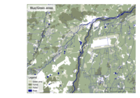
If you look at the water structure mapping of Bavaria rivers from 2017 you can see how they are rated from natural to heavily modified. Heavily modified river landscapes can be found in and around the city of Freising in red color. However, east of Freising near the city of Marzling are blue lines which represent natural riverscapes. This area is a protected floodplain forest. This map can also give an idea about the water quality of the river but where the river landscape is heavily modified the river does not have a natural way to clean itself, therefore those areas can have worse water quality.
-
 Waterstructure Map
 -
 Protected Area
 -
 Groppe Fish
 -
 Corncrake
 -
 Southern Damselfy
 -
 Forest Orchid Ladys Slipper
 -
 Bats
Bats -
 Common Kingfisher
 -
 Woodpecker
 -
 European Honey Buzzard


Blue and Green Infrastructure
Large forest areas can be found around Isar, however there are large areas that don't have a cohesive forest, just small patches of trees. The main reason for this could be the large amount of agricultural land where the land use is mostly for food production. This also leads to lack of diversity and poor variety of vegetation which is bad for ecosystems. Blue infrastructure is very limited to the rivers and most of the lakes in the area are man-made.
If there is no change in man's behavior regarding vegetation diversity, this can lead to the extinction of many ecosystems.
-
 Blue and Green infrastructure and land use

Water as a cultural space
Land use and water

Few fish farms/Aquaculture can be found on the banks of Moosach. These businesses can produce a lot of waste and can be a breeding ground for diseases. If the waste and the diseases get into the natural water system it can have a devastating effect on ecosystems in the area.
In the city of Freising there is a sewage treatment plant but they can have effects on the biotic status of receiving rivers and cause pollution if the plant is not equipped with a proper filtering system. Few hydropower Stations can also be found on the river but they can obstruct fish migration and harm water quality and habitats, even though they installed fish stairs for contribution to the environment.

The riverscape of Moosach has changed a lot throughout the centuries. The first major change to the landscape was in 1858 when a new train station was built in Freising. The new train tracks had a huge impact on the landscape in the sense of being a splitting element. Another huge factor in the change of landscape around Freising is the Munich airport. It has grown bigger and bigger in the past years with traffic networks and settlements growing exponentially.
With all of these new developments the river structure has been affected in a big way. Large parts of the Moosach have been straightened and become heavily modified; this has happened especially after 1938 when Freising development exploded. The reason for this is for example to adapt city development or infrastructure to get larger farmingfields. Or they need more land for infrastructure and the river is in the way, they will just move it somewhere else and it usually becomes unattractive for the urban areas. The result is that the river flow can become much faster and be a bad impact for biodiversity.
-
 Fish farm
 -
 Another fish farm
 -
 Electro station


Cultural and spatial typologies of water areas

Many different uses of the Moosach have led to the form it has taken today. To disperse water flow during flood is one of those uses but also to distribute water to fight fire, for example the Weihenstephan pump in the 16th century. In the map below you can see how many mills were in Freising. We can imagine that there were a lot of conflicting interests between mills, as changing the flow to suit one mill often disrupted another. But sometimes they did act collectively.
In the illustration is the river on Hauptstraße, a section called Niederbach. This section was actually key to the development of the town. Niederbach was laid out as a ditch around 1300 when the surroundings were mostly moor, and then structures began to be built along it. It was mostly used for cleaning and then it was first covered in places starting around 1760, because it was a health hazard and had an extreme odor. So that was the initial reason for it to be covered, which we are now uncovering. So many of these uses are not relevant, but flooding still is.
Water and People
Accessibility and usability
The Moosach has a mix of accessible and inaccessible areas. There are few recreational areas for people but also untouched areas without human footprint. Some areas that we noticed on our field trip were:
-
 Wonderful wooden bridge connects both sides of the river and also gives the opportunity to stand for a second and enjoy the view and the cooling effect of the river
 -
 Modified river parts that are helpful for collecting water samples, service/maintenance sampling
 -
 Inhabitants that want to use and enjoy being close to the water
 -
 Shallow areas that offer unrestricted access to the Moosach
 -
 Various architectural constructions attract people to the water
 -
 The river was adapted in certain areas to the urban development
 -
 Homemade infrastructure that make the access to the river possible
 -
 Rural part where the humans are in the background
 -
 Part of the river in the urban area where nature is the main actor


Community Mapping
We are focusing especially on the rural areas outside of Freising. Based on accounts of how cooperation with farms is key to successful implementation of new policies for environmental protection, we hypothesize that the key landscape democracy challenge will be uniting farmers with people in the city of Freising in completing mutually beneficial projects in the Moosach waterscape.
Freising is a middle and working class community that is greatly shaped by its proximity to a large international airport and the city of Munich. The campuses of HSWT and TUM mean there is a proportionally high number of young people.
Munich’s growth has put pressures on the real estate market and regional transportation. We wanted to look deeper into how it will grow and what ways this might influence development in the area in the future.
The projected continued growth of Munich will lead to increased spillover into the surrounding areas, including between Unterschleißheim and Freising which encompasses the Moosach. Looking at projected jobs, we can see that industries like manufacturing are not expected to increase, but information and service sectors will. We will use this information to hypothesize about the types of land use we might see expanding in the future around Freising, and how this might change the community of our project area.
We researched businesses, planning entities, nature groups, and others, and plotted them according to their importance, and then again according to their power.
-
 Local stakeholders
 -
 Needs and Power of stakeholders
 -
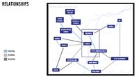 Relationships between stakeholders


Possible Futures
DPSI(R) Model
We analyzed 3 important problems and made them as the current state in our DPSIR model. These are lack of diversity in vegetation, polluted water and flooding. The key issues are the pressures from housing and other development, as well as agriculture. The state of the river has a negative effect on different fields like human health, agriculture, for species etc. To improve the state we came up with options like having policies and regulations, protecting native vegetation, educating people etc.
-
 DPSIR
DPSIR

The Sustainable Development Goals
The Sustainable Development Goals from the United Nations that can be linked to our Riverscape are:
- 3- Good health and well being:
- If the river is in a good natural state it can have a good effect on all surrounding ecosystems as well as humans. It has also been proven that water landscapes have good qualities on human mental health.
- 4- Quality Education
- Education can have two different meanings for our waterscapes. First on a small scale, where people get educated about Moosach river and its surroundings. What is important about it and why do we need to take good care of the watersystems. On a larger scale, people are educated about water systems in general. How they are important to our existence on earth and have an impact on all life.
- 6- Clean water and sanitation
- Clean water is very important to our river and surroundings. Polluted water can have devastating effects on ecosystems and human lifes. Good sanitation is very important since we have many human activities around the river such as fish farming, agriculture and urban areas.
- 7- Affordable and clean energy
- Our river contains few hydroelectric plants, which is considered as clean energy. However there is always an effect on the ecosystem when the river is dammed. There are few ways to gain clean energy from this river, but it needs to be implanted the right way so it will not have a negative effect on natural systems.
- 11- Sustainable cities and communities
- The Moosach runs through a few urban areas. The city should be aware of the water system and try to connect the river to the community with green areas. The community needs to take care of their river to keep it clean and healthy. The cities need to develop new urban areas in a good relationship with the river.
- 13- Climate action
- Climate change is also having a big effect on small rivers like the Moosach. Small rivers can become huge monsters in a changing climate where more rain is becoming more common, but also be lost to drought. With global climate action, these issues could be reversed and fixed.
- 14- Life below water
- This goal is very important to this river. Without river vegetation it will not have a natural cleaning system. Without clean and healthy water there will be no life below water.
Our main goals for this project was to have good water quality, more biodiversity and make Moosach more visible. All of these goals can also be related to the SD goals
-
 SDGs
SDGs

Scenario #1 Urban Suburb
In this scenario, development accelerates in Freising and other communities outside of Munich. The development is very urban. Freising becomes much more dense, and other communities along the Moosach like Eching also see the same. The Moosach becomes more artificial in structure, and is further canalized during this development. In our analysis, we looked at how the economy and the population in the Munich region is projected to keep growing. But due to bottlenecks in Munich, population growth is projected to spillover into surrounding cities like Freising. The Urban Suburb scenario extrapolates from this trend. Planners in Munich are already working towards more polycentric development, where cities like Freising become economic centers themselves.
PESTEL factors for the Urban Suburb were analyzed. In this scenario we assume more international migration to Germany and the Munich region. The political-economic reaction to this migration, and to economic disruptions due to climate change, is to prioritize business activity and growth at the expense of sustainable agriculture or environmental protection. We do see more renewable energy investment and EV, but this only further reinforces car dependence.
So in this scenario, these pressures make Freising more dense and cause development to expand outside of the city. The structure of the Moosach becomes more artificial. The economic benefits of this come at the cost of worse water quality and degradation of the ecosystems connected to the Moosach. Also, more homes will be within flood risk areas, and the flood risk areas themselves will expand because of the increased soil sealing around the river. Flood events will happen more often because of climate change, and in this scenario rather than mitigating, the urban development is making these problems worse. With increased drought events, we could also see periods where the Moosach is dry. Rather than using the river as an opportunity for recreation and life in the city, it becomes just an obstacle in the urban landscape.
We would like to introduce two people from the future, in the Urban Suburb in 2050.
First we have Judith, who is 70 years old. She’s a retired teacher, and she wants areas to walk near her home in Freising. The areas available next to the river are small and degraded due to urban pressures.
Next we have Hans, the 35 year old farmer outside of Freising. His family’s midsize farm was partially bought by a larger farm, and so his now small farm has a more precarious existence. The larger farm does intensified monoculture farming, and Hans adopts some of the same approaches to compete. He hardly has time to consider his impact on the river. Fertilizer, soil runoff.
-
 PESTLE factors
 -
 Freising 2020
 -
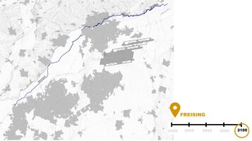 Freising 2100
 -
 Diagram
 -
 Urbanised City
 -
 Scenario 1


Scenario #2 Fewer, Greener, Cooler
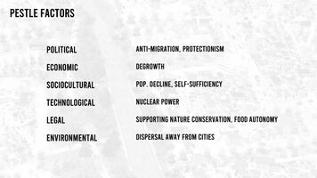
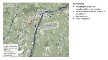
In Fewer, Greener, Cooler, we imagine a Munich area that has actually shrunk in population slightly from today. Lessening the impact of climate change on people and ecosystems has taken a bigger role in agriculture and environmental policy, and so here we can see the increase in protected areas, buffers, and corridors between them. The Moos have been connected with the alluvial forests along the Isar. Because migration to the area has reached equilibrium, expansion of Freising has stopped. But the farmland has also become more sustainable. In this scenario, pressures from climate crises have resulted in some divergence from current trends. Munich has little or no population growth because of a political climate that has, after several large climate disaster migration events, become very anti-immigration. Similarly, there is a strong emphasis on self-sufficiency and food autonomy. More crops are grown for local consumption as opposed to export, and this is supported by government policy which incentivizes sustainable agriculture. Using land for solar power generation is deemphasized in favor of nuclear power technologies.
Now we return to Judith and Hans, but in a different future.
Judith has many areas to walk. Less danger to her health from heat, because of regulating ecosystem services. Water is more plentiful. Hans keeps his farmland. Growing a variety of crops, which he sells locally. More stable income for him and those who work on his farm.
-
 PESTLE factors
 -
 Current situation
 -
 Freising 2050
 -
 Diagram
 -
 Our vision
 -
 Landscape now
 -
 Landscape 2050
 -
 Scenario 2


Collaborative Goal Setting
After analyzing the riverscapes of Moosach river we found three main issues that we would like to address. First we noticed that in many places the water itself was not very clean. Also waste from humans can be found in and around the river. Lack of biodiversity was also something we noticed. With so much agricultural land around the river it can have a bad effect on ecosystems. Also in urban areas the river is heavily modified and canalized in many places with no natural surroundings. The last problem we ran into was that the river is not very visible or accessible in large areas. In the rural areas it runs through a lot of agricultural land where it is not accessible by people. In urban areas it is sometimes in closed-off canals and underground pipe systems. With these issues we came up with our goals for our project. Those goals are to have good water quality, more biodiversity and make Moosach more visible
Spatial Strategy and Transect
Freisinger Ecodistrict
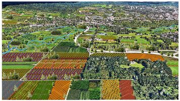
We have started to imagine how some of the positives from each scenario could be combined, while avoiding the negatives. The result is a concept for the Freisinger Ecodistrict, which could be a model for sustainable development. We anticipate future migration and provide living space, while strengthening ecosystems and creating a better quality of life, with the river at the center of many of the amenities in the district. The ecodistrict keeps the river renaturalization from the last scenario, and the expansion of buffer areas and green corridors. These green spaces extend into parks which weave throughout social housing developments. This development is medium-density and integrated with new bus or even trolley lines with Freising city center to connect with regional transit. Bike and foot paths cross the moosach. Cars are absent. Buildings themselves have low-carbon architecture. Open space is plentiful, and used for things like gardening for food production, which approaches the scale of farming and blends with sustainable farming at the edges.
-
 Synthesis Ecodistrict 2050
 -
 Detail


References
Bauer, Markus & Thuro, Kurosch & MARCUS, SCHOLZ & Neumann, Peter. (2005). The geology of Munich (Germany) and its significance for ground modelling in urban areas. Geotechnik. 28.
https://www.sueddeutsche.de/muenchen/freising/freisinger-moos-moor-umweltschutz-1.5225243
https://www.sueddeutsche.de/muenchen/landkreismuenchen/klimaschutz-etwas-moos-fuers-moos-1.5450603
https://stadt.muenchen.de/infos/wirtschaftsfoerderung.html
https://www.wirtschaft-muenchen.de/produkt/erwerbstaetigenprognose-muenchen-bis-2030-kurzfassung/
https://www.wirtschaft-muenchen.de/produkt/real-estate-market-report-munich-2022-2023/
https://www.ecovillage-hannover.de/wohnen-im-quartier
Process Reflection
We faced several difficulties in our groupwork. For example, reaching agreements on some contents of our presentations. It was also difficult to do many online meetings because the team members were separated and did not work together and sometimes language barriers were difficult. People misunderstanding each other happened on few occasions. Time management was challenging due to the absence of some of the group members from the site because of visa- and health issues.