Freising Waterscapes Team 3 2022
>>>back to working groups overview
| Area | River "Moosach" and its surroundings | |
| Place | Freising | |
| Country | Germany | |
| Topics | Analysis and scenario building of a river landscape | |
| Author(s) | the Fluss Floaters:
Kees van Roon, Fabrizio Albion, Gentiane Thaci, Delaram Kouhestani, Nora Buffham | |

| ||
| A artistic depiction of the current state of the Moosach | ||
Rationale
- Why do you think this case is relevant? What is your hypothesis considering the landscape challenges?
- Format: 3-4 sentences
Location and scope
You can edit this map with the map editor
Water as a natural system
Geomorphology, typologies and dynamics of water areas
Context
The river Moosach is a tributary in the Danube river Basin. The Moosach, with it's source in Unterscheissheim, is a spring water river that flows into the Isar. The Isar connects to the Danube near Deggendorf, close to the German-Chech Republic border. Clearly to see is the small scale of the Moosach river in the bigger context, but also the large impact the water can have on a long stretch of Europe's largest river.
-
 The Moosach in it's context

Water system
The Moosach, especially in and around the city of Freising, has a complex water system. As visible in the figure below, the Moosach has many elements in the river flow, especially compared to the river Isar just south of it. Most of these elements consist of wears to regulate the hight of the water. The complexity is a result of many years of using the Moosach as a energy source for the many mills that used to be in the area. One of these mills is still active in Freising, used as a hydropower plant. This plant can be seen as the red symbol on the map.
-
 Watersystem and fauna/flora in the Moosach

Climate change
Just like anywhere in the world, the climate around the Moosach is changing. The trends in the changing of the climate are clearly visible in graphs. The temperature is ever rising, and precipitation is reducing. This will project a future of heat and draught in the area, with peaks of precipitation. This will have a great effect on the ecosystem and human wellbeing in the area as the result of heat stress, draught and flood risks.
-
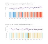 Climate Change in Freising

Floodings
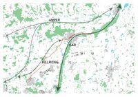
The river Moosach has a history of floodings, with locals living in flood plains having to evacuate every few years. This problem will, according to the projections of precipitation peaks, only get worse. In the figure below the cause and effect are shown. The waterflow of the Moosach is greatly affected by rainfall in the local area and the ridges of the hills in the north. Due to canalization in the 1930's, the river has been straightened resulting in a fast flow of water. When this fast flowing water flows into the complex water system of Freising, problems arise. Water builds up and is not contained by dykes (like the river Isar). The result is agricultural, and residential area's being flooded with economical cost and the possible loss of human life.
-
 Flood risk map

Water as a living space
Water quality
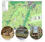
In general, the water quality of the river Moosach is described as good. However, problems with overfertilization and water temperature have arisen. The Moosach has been used and adapted since the 1930 to drain the surrounding Freisinger Moos as agricultural land and as a place for fish farming. This has lead to problems in floodings, but also erosion and overfertilization of the river. This leads to the overpopulation of Macrophytes, water plants that take oxygen away from water fauna. This problem is also getting worse because of the open landscape, were the lack of shade in the river leads to high water temperatures. These temperatures lead to illness in trout species. Fauna also gets hindered by the many elements in the water system.
Fauna and flora around the Moosach
The surroundings of the Moosach river is a habitat for many endangered plant -, bird -, and butterfly species. In a large part of the Freisinger Moos the bird habitat is protected. This gets improved by the local use of the area as a drinking water source. Pesticides and chemical fertilization is prohibited here.
-
 Species in the Freisinger Moos

Blue and Green Infrastructure
On the bigger scale, the importance of the Isar river is clearly visible. Not only is it important on the local level, but also international. The green-blue infrastructure connects the center of Munich with the Danube near the Chech border. This connects it all the way to the Black Sea. Also the green-blue infrastructure of the Amper river is important on the local level, just as the green infrastructure of the hill ridge line. However, this is not connected to the Moosach.
The reason of this, again, goes back to the exploitation of the Moosach and the Freisinger Moos in the 1930's. Although a small part of the Freisinger Moos remains, most of the surroundings are lacking in forest. This can be seen again when looking at the protected area's, where this pattern returns.
-
 Green blue infrastructure
 -
 Protected area's


Water as a cultural space
Land use and water
Over the centuries, the waterscape of Moosach river has been considerably altered by human activities, especially with the intensification of agriculture and urbanisation of the region. Today, agricultural land use covers most of the territory and has caused the canalization of the entire river, damaging the natural environment of the Freisinger Moos, the extensive flat mossy area between Freising and Munich. Furthermore, this area is also subject to constant change due to grey infrastructures, from the construction of the Munich-Freising railway in 1858 to the new Westtangente road in January 2022. These constructions are at the same time causes and effects of the expansion of urban areas, especially the Munich metropolitan area. On the contrary, Freising has remained a small compact city for most of its history and only in the last thirty years has it started to expand rapidly, mainly due to the new presence of the International Airport of Munich. It covers a large area in the southeast of Freising and its further expansion is still a possible threat for the territory, along with the continuing demand for housing in the city.
-
 History of the Moosach
 -
 Landuse around the Moosach


Cultural and spatial typologies of water areas
Starting from the open landscape of the Freisinger Moos, the river divides itself into many channels, partly still covered, running through the concrete landscape of Freising. Its canalization from source to mouth has been realized to its use for agriculture, fish farming, hydropower and drinking water.
-
 Spacial analysis Moosach

Sacred spaces and heritage
The main cultural values of Freising and its surroundings have been strongly present for centuries, from its famous products, beer and milk, to its identity as a university city. Freising is also known as an important religious center and for its garden culture. These values are clearly visible in the city’s landscape, especially in the presence of churches, notably the Dom St. Korbinian on Dom Hill and the Korbiniansbrünnlein on Weihenstephan Hill. This latter hill is famous for being part of the university campus and for the Weihenstephan Brewery, known as the oldest brewery of the world still open. Along with the historical center, these identity places are commonly used and visited from both locals and tourists alike.
-
 Identities of Moosach
 -
 Monuments around the Moosach


Visual appearance and landscape narrative
Moosach takes part of a special encounter between two different spatial landscapes, from flat to hilly. Mainly due to the presence of the river, it was there that the foundation of the city of Freising began, firstly on the two well-known Dom Hill and Weihenstephan Hill.
In numerous paintings of the Freising landscape the same characters always appear, which are still easily recognizable today. For example, we have identified most of the main historical values in a painting from 1698, where we can see the river, the Freisinger Moos, the compact city of Freising, the historical Weihenstephan garden and the surrounding agricultural fields.
-
 Identities in a 17th century painting

Water and People
Accessibility and usability
The Moosach River flows along with urban spaces, rural spaces, and farms. Out of the city, the edges of the river are natural and there are not many public paths. In urban spaces, the water areas are more accessible by the walking and bike routes along the river. Some transects of the river are covered and because of channelization, it is not easy to touch the water in Freising. Most boundaries of the Moosach River are soft around Freising. But as we get closer to the city, the boundaries are getting more concrete. The interactions between people and the river are limited to countless spaces for sitting or bridges for crossing the river.
The Moosach River is exploited for agriculture, fish farming, energy (hydropower), housing, transportation, and drinking water. The people who use the spaces generally are the internal stakeholders. Additionally, the people that we had interviewed are more locals and students. There is no intensive activity and most of the people’s activities are just for relaxation or while traveling by bike or on their feet. According to the varied social, cultural, and artistic events that we found in Freising during the year, the most important events are held in the center of Freising (Marienplatz) and there is not a lot of connection to the Moosach.
-
 Accesability
 -
 Activities of interviewed people around the Moosach
 -
 Activities and events around the Moosach


Community Mapping
What is to be mapped here?
- Social groups from within the community, for example the youth, kids, students, parents, the retired etc. Typically, these groups have specific needs, which you can also make explicit on the map. These people might not be organized in any way, but they are usually present in the context you are observing
- Local stakeholder groups: these groups are organized in one or the other way. They only exist within the community context you are observing. For example: the local community center, local churches, local interest groups, the landowners, small businesses and retailers
- External stakeholder groups are not necessarily present in the environment you are observing, but they may have strong stakes and interests. These can be local authorities, politicians, associations, care services etc.
- For each group, you may identify their needs, objectives, power and capacities
- You may also identify gaps and power conflicts
- Please try to redepict these elements in an integrated way and in relation to your water landscape. What is the relationship between these groups? Are they close or distanced from each other? Who is more powerful? Which voices are hardly heard? Do they have any shared concerns?
-
add a caption
-
add a caption
-
add a caption
Possible Futures
Analysing the project area, we used three main frameworks (DPSIR, SWOT, Riskmapping), identifying all the aspects which have to be considered before planning a new scenario. In the waterscape of Moosach, the Sustainable Development Goals which are at risk are mainly the ones threaten by the climate change risks, the flood risks and the growing of the population: water and soil as limited resources, health and well-being and economic and social stability.
-
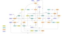 DPSIR of the current state of the Moosach
 -
 SWOT analysis of the Moosach
 -
 Riskmapping the treats


Collaborative Goal Setting
- Define strategic planning objectives based on the evaluation findings from your analysis
- Ideally, involve the community of your living labs into this process
- Link back to your original targets from section one and the Development Goals
- 150 words text contribution
Spatial Strategy and Transect
- translate your strategic goals into a vision
- develop a spatial translation of your vision
- exemplify your vision in the form of a transect with concrete interventions
- add map(s) and visualizations
-
add caption here
-
add caption here
-
add caption here
-
add caption here
From Theory of Change to Implementation
- For implementing your vision: Which partnerships are needed? Which governance model is required?
- Who needs to act and how? Draw and explain a change/process model/timeline
- Which resources are needed? On which assets can you build?
- add 150 words text and visuals
-
 add caption here
 -
 add caption here


References
- give a full list of the references you have used for your case
Process Reflection
- Reflect in your intercultural and interdisciplinary team on the outcomes of your study
- Which limitations were you facing?
- What have you learnt from each other?
- What did you learn in the Living Labs?
- What would you do differently next time?
- You can also use diagrams/visuals
- 250 words text