Fusaro Lake WAVE Living Lab 2021
>>>back to working groups overview
| Area | Phlegraean Fields | |
| Place | Bacoli, Fusaro Lake | |
| Country | Italy | |
| Topics | archeological potential, fragmented landscape, water shapes | |
| Author(s) | Ambrosino Ines, De Maria Federica, Di Rosa Maria, Gargano Alessandro, Liguori Andrea, Séjourné Théo | |

| ||
Rationale
- As a part of the Phlegraean Fields, Fusaro Lake and its surroundings represent a cultural legacy for the mediterranean civilization, testified by greek mythology and history. Therefore archeological sites, which represent this heritage, should be enhanced as cultural goods.
- Thanks to its volcanic nature, this landscape owns different resources that constitute an opportunity for territory productive and economic developments.
- Biodiversity plays a key role in the management of the area and it should be protected and highlighted. Pollution and abusive settlements should be adressed and regulated before unsustainable development degrades ecosystems.
Location and scope
You can edit this map with the map editor
Water as a natural system
Geomorphology, typologies and dynamics of water areas
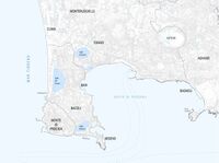
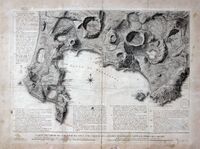
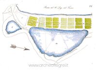
- Fusaro Lake belongs to the Phlegraean Fields, a geographical area located in the Gulf of Pozzuoli, in the northwestern part of the city of Naples and its gulf, famous since ancient times for its vigorous volcanic activity, consisting of a large caldera in state of quiescence with a diameter of 12–15 km. The Phlegraean territory is characterized by numerous lake formations of volcanic origin (Lake Averno, Lake Lucrino) and coastal lakes generated by barrage (Lake Fusaro, and Lake Miseno).
•Averno Lake, enclosed between steep wooded slopes, has a surface area of 0.55 square km and a maximum depth of 34 m. it lies within an extinct volcanic crater, born 4,000 years ago. In fact, even the poet Virgil in the sixth book of the Aeneid places near this lake the mystical entrance to the Underworld.
•Lucrino Lake is currently located on the bottom of a volcanic crater very close to the coast, but it is not exactly of volcanic origin. Initially it was part of the coast from which it then moved away by forming an isthmus due to the continuous movement of the wave motion.
•Miseno Lake has an extension of more than 40 hectares and a perimeter of about 2,800 meters while the average depth is 2.25 meters and the maximum depth of 4. It is separated from the sea by a sandy barrier about 200 meters wide but is connected with it. through two mouths: the first located near the town of Miliscola and the second located near the bay of Miseno.
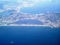
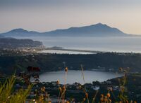
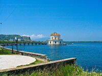
•Fusaro Lake is the largest of the Phlegraean lakes, located close to the Torregaveta promontory, separated from the coast by a thin strip of sand. The lake was formed with the closure of the stretch of sea through a tongue of land. Its perimeter measures approximately 4.10 km and has an area of 0.97 square km. It is characterized by brackish water, two channels were built to facilitate the exchange of water, one from the Romanesque period and one from the 18th century.
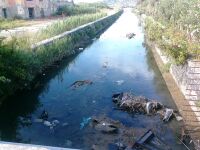
- Water management of Fusaro lake and its surroundings appear disregarded, especially Water Caves (Grotte dell’Acqua). The ancient thermal cisterns are in a state of severe neglect. Instead, Lake fusaro, the richest and largest of all the Phlegraean lakes, has a medium pollution rate caused by the increase of temperatures and is favored by not healthy water conditions. The boom in algal bloom, in general, according to biologists, would also be encouraged by pollutants. The mucilage, in fact, a natural phenomenon exacerbated by poor oxygenation of the water, would be affected by the presence of particular nutrients introduced by man.
- Lake Fusaro consists of 98 hectares of lake surface and a total extension of 135 hectares. It still preserves stretches of reeds on the banks, however, mostly embanked and cemented, on which the old park stands, which enriches the arboreal endowment. it is connected to the sea by three channels, and inside it is practiced the breeding of fish and molluscs. The lake was exploited for the breeding of mussels and oysters by the Greek and Roman populations who had built splendid villas in its ravines. At that time, in fact, the lake did not yet exist and the area appeared as a large gulf. Only after the first century A.D. a sandy strip formed due to the scarce ebb of the tides transformed it into a lagoon and therefore into a coastal lake. In Water Caves, instead, despite the presence of a gate to protect the archaeological site, garbage and clothing lie in the rooms of the ancient baths. The waters that rise from the subsoil have a temperature of about 40 ° and are rich in minerals equal to those that arise in Ischia ". In Ischia these waters," miraculous for the ancient Romans, of great value for the Bourbons ", are appreciated by tourists and sponsored: in the Fusaro park "Grotte dell’Acqua" are abandoned and a few days ago a piece of the vault also fell. Ferdinand 4 of Bourbon had great consideration for these archaeological sites.
- The territory of Lake Fusaro is often characterized by flash floods causing numerous damage every year. The major recent flood events are those of 2011 and 2017 which recorded rainfall values exceeding 100 mm in a single day.
-
 Water system of Phlegraean Fields
 -
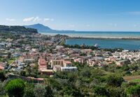
 Fusaro lake and its surroundings
 -
 Fusaro lake and its surroundings
 -
 Fusaro lake and its surroundings
 -
 Fusaro lake and its surroundings


Water as a living space
- On site, 40 percent of the area owns habitats in a good or excellent state of conservation. On the remaining part, habitats are in a good to poor state of conservation. This phenomenon is due to a strong presence and anthropogenic pressure. Moreover, the soil use spatial distribution enhances this evolution as naturalized areas are mixed with agricultural lands. This territory fragmentation disrupts forest and coastal environment. Regarding fauna, local species are endangered by predators such as cats and dogs and more specially during nesting periods. Regarding flora, meadow habitats can be found on the surroundings of Fusaro lake. This kind of vegetation was maintained by mowing or grazing activities. Depending on the state of abandonment these habitats are slowly and naturally evolving towards more mature forms of shrub vegetation.More precisely, Fusaro lake was used for aquaculture during the roman era and it still hosts cultures of fish and mussels. Today, is affected by the artificialization of most of the banks, by the presence of mussel’s intensive cultivation and various sewage discharges. However, reeds can be found alongside cemented banks and tall trees testified the presence of an old park. On the sand coast a typical Mediterranean maquis shrubland is well preserved despite the arrival of a new mouth.
- Regarding marine bathing in Bacoli, it is considered excellent. Despite this, in this area for years environmental pollution, the lack of infrastructure - especially the sewer system - and an old purifier, have blocked economic development and conditioned the daily life of thousands of people. Bacoli has only three non-bathing areas among its beaches, fortunately. All on the Roman beach: Lido P.S, Colonia Vescovile and Lido Fusaro. The waters of the canals are polluted by illegal civil, industrial and agricultural-zootechnical discharges that cause widespread pollution that is not under control. The illegal discharge was eliminated only in 2020, and due to its presence for over 10 years, it has contributed significantly to polluting the waters of the lake and of the sea.
- The site has a typical formation of a strongly anthropised retrodunal lake both along the edge of the lake on the eastern side and in the belt separating the dune-backdune from the sea. The morphology of the coast, the presence of the sea, the various productive activities linked to the lake since the Roman period, have encouraged the exercise of economic activities in the area. The site has undergone intense anthropogenic pressure mainly linked to the construction of buildings for residential purposes, many of them are likely to be illegal. Today agricultural activity plays a very niche role in the local economy. The lower practice of traditional activities was accompanied by a reduction in the number of employees in the primary sector and leading to a decrease in actively managed areas. This entailed the maintenance of niche agricultural activities linked to tourist reception facilities, and conversely the construction of bathing establishments that have involved a strong compromise of the dune and back dune belt where today you can read sparse strips of what was the expanse of scrub and holm oak. In recent years, illegal dumping and burial of waste in agricultural areas have been reported. The properly urbanized areas are outside the borders of the site, but within them there are numerous episodes of construction, including conspicuous ones, many of which are illegal. Particular attention must be paid to water and sewage discharges, which are evidently present. At the borders of the area there is the industrial settlement of Alenia whose production processes should be monitored. Illegal dumps of asbestos have also been reported along the municipal road around the sea side.
- The lake is unsuitable for fish survival due to its brackish nature. It was once known for the cultivation of mussels, whose fishing is now prohibited due to the heavy pollution of the waters.
The lake communicates with the sea through three mouths:
• The first to the south, called Foce Vecchia or Romana, is located near Torregaveta, has an 800 m long mouth channel with a span of 5.5 m and a depth of <1m;
• The second in the center of the reservoir is called the Foce di Mezza Chiara, and connects the lake and the sea with a 500m long canal with a span of 10.6m and a depth of 1m;
• The third northernmost mouth, Foce Nuova, has a 700 m long outlet channel, a span of 10.6 m and a depth of 1m;
The flow rate on each channel is regulated by a series of double gates which are in a serious state of neglect, which has led to a worsening of the water conditions of the lake.
-
 Urbanization around the lake
 -
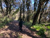 Beech wood
 -
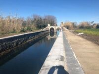
 Fusaro Lake center channel
 -
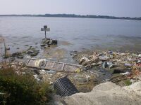 Dumps fusaro lake


Blue and Green Infrastructure
- Green and blue infrastructures are planned and managed networks of natural and semi-natural areas on the territory, capable of providing multiple environmental and social benefits. The potential green area on the territory examined is undoubtedly the fusaro lake. The lake area with the adjoining park is not properly exploited, due to water pollution and the prohibition of bathing in danger of deteriorating more and more over time. the mayor of bacoli has therefore implemented a redevelopment plan: " We have obtained a loan by which we will also go to restore and enhance, and finally to make it available to the public, the Grotte dell'Acqua, a thermal complex from the Roman era and reused in the Bourbon period, as well as a site from which a thermal water spring flows, so far wasted and very few known. A new archaeological and Bourbon heritage that will finally be open to visitors again. And finally, we will complete the works on the parking lot next to the Parco Vanvitelliano, expanding it to accommodate citizens and tourists. Allowing us to make the route that connects the Cumana del Fusaro station, the Real Bourbon Park, the Circumlacuale del Fusaro, the Quarantenario Park safer. Up to the Roman beach and the Cumana Acropolis. A walk to be experienced on foot, by bike. There is still a lot to do for our city”. Those who remembered it as a tangle of reeds, garbage and brush inhabited by rats no longer recognize it. The mouth of the Fusaro, one of the freshwater mirrors of the Phlegraean area, is preparing to become a "cycle-pedestrian. The program includes not only cleaning the seabed, but also a walk among flora and fauna, immersed in nature. On foot, or by bike, from via Cuma you can reach the Casina Vanvitelliana.
-
 Infrastructures green and blue
 -
 Future cycle-pedestrian path


Water as a cultural space
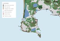
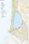
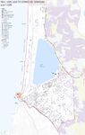
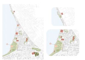
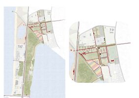
Land use and water
- map the land uses along your water areas: settlements, infrastructure, agriculture, resource extraction, natural areas, energy production...
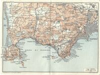
- In Image 1 and in Image 2 is clear as Bacoli is divided into different areas:
- Residential areas (mainly civil and rural buildings);
- Agricultural areas (vineyards, orchards, greenhouses, arable land, wooded areas);
- Natural areas (parks and reserves);
- Industrial area;
- Touristic area;
- Infrastructures (road network, rail system, harbour system);
- Equipment (parking areas, schools, public and sports buildings).
- describe in particular the historical evolution of land use pattern, please make use of historical maps
- Bacoli was founded by the ancient Romans who called it “Bauli”. During the Augustan age it became the main military outpost and, together with Baieae, the political and cultural capital city. From the II century to the IV century the Romans built a lot of luxurious villas full of marble and mosaics. They took advantage of the territory and of the thermal waters’ therapeutic power. They also built bridges and pools to connect different parts of the city. Following the fall of the Roman Empire, Bacoli lapsed because of two phenomena:
- Geological issues like bradisism and erosions;
- The Barbarian invasions.
During 1600 a group of neapolitan Jews gave rebirth to the city by farming and fishing. Until the middle of the XVIII century Fusaro lake was used for mussels and oysters cultivation and for hunting. Ferdinando IV of Bourbon built his royal casina upon a lake small island. Successively the city became one of the favourite destinations for the europeans. Starting from 1850 there is a massive demographic growth which brought an increasement of the residential settlements, this phenomenous continued during 1900 especially with the building speculations of 1970. Today in Bacoli there are mainly residential buildings and agricultural areas, the coast is used as a bathing area.
- description evolution, status quo and driving forces, is the land use likely to change? Why is that? (approx 200 signs)
In the city of Bacoli there are many important landscape and natural resources but they coexist with degradation and disorder caused by an inappropriate land use and by modern widespread and disorganized urbanization; the area is also characterized by many problems caused by hydrogeological and volcanic risk. These situations contitute a emergency for the territory, in fact they brought to the production of a lot of projects (even if they have never been put into practice). Due to the master plan of the 70s, disreguarded in the concrete accomplishment, there has been a speculative and spontaneous land use. The territory of Bacoli is characterised by a large mixture between settlements and environmental system, this condition, considering the high landscape and environmental quality, brings to the pressure on undeveloped areas by the settlements system. This pressure determines the landscape depletion, in fact they are inappropriately used (such as parkings, open-air dumps, ecc.), and it determines an ecological impoverishment. This process involves a series of phenomena: a drop of beauty of these places, demages to the primary environmental resources (sea, beaches, crater system), the slow-down of the local develpment. The antropic pressure and the infrastructure inadequacy cause the increase of the hydrogeological risk.
-
 add a caption
 -
 add a caption
 -
 add a caption
 -
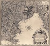 1754, Caer Weber
 -
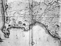 1761, N. Van Aelest
 -
 1778, De La Vega
 -
 1800
1800


Cultural and spatial typologies of water areas
- Which spatial patterns have evolved in relation to your water areas?
The city of Bacoli is characterised by residential and commercial areas near the sea and lake coasts. There is also an industrial area to the south-east side of the lake. Lake water is not bathing and the commercial and touristic activities are displaced from it but in its proximity there are green areas such as parks and villas. The sea area, which continues up to the Licola coast, is characterised by the presence of commercial activities (shops, equipped beaches, restaurants, camping area). Until the 50s a lot of the touristic activities were related to the presence of thermal water, today these ones are not exploited beacuse of the bad organization by the Administration.
- What is the role of water areas within the overall urban morphology? (approx 200 signs)
Water areas play a key role in the urban morphology of Bacoli, many areas are destinated to bathing activities and the majority of commercial activities developed in proximity of these areas. The rest of the territory is composed by agricultural areas which are favored by the presence of water in the subsoil, that's why we can say that all of the Bacoli areas are there thanks to its presence. This presence modified the soil during the years, until 1800 between Fusaro Lake and the spoles of Monte di Procida there was another little lake called "Acqua Morta" (Dead Water) which finally dried up by men because its water was dirty and it affected Fusaro Lake fauna.
-
 Parco Vanvitelliano
 -
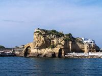
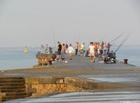 Torregaveta jetty
 -
 Acqua Morta
 -
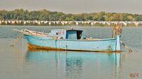 boat on Fusaro Lake


Sacred spaces and heritage
- Which places/elements hold cultural value and to whom?
As a part of the Phlegraean Fields, Fusaro Lake area has got many cultural places, sometimes they are not even known from the population of Bacoli itself, but they constitute an important heritage for the mediterranean civilization.
- CERBERUS CAVERN
The name "Cerberus cavern" comes from the fact that Virgil probably took his inspiration from this place to describe the entrance to the Underworld of which Cerberus was the guardian. Between the II and I centuries B.C., the roman “nobiles” built villas and thermal baths near to Fusaro Lake, the most famous one was Servilio Vatia’s domus. According to some historical record the mouth of the Cerberus cave was used as a tunnel connecting the landing and the part behind of Publio Servilio’s villa. Successively, because of the morphological concerns caused by bradisism, it has been linked to Fusaro Lake.
- VILLA SERVILIO VATIA
Today only some rests of Publio Servilio Vatia's (roman commander and poltician) villa remains, some of them are visible and other ones are incorporated into a restaurant. The villa was so beautiful that the Romans used to say: “O Vatia, tu solus scis vivere” (= “Oh vatia, only you know how to live”). The domus was erected between the end of the Republican age and the Augustan age, it was built upon a tufaceous rocky spur overworking the natural structure of the ground and using artificial substructions to ensure that the villa was distributed in terraces. This position allowed the owners and their guests to enjoy the sea breeze and the sun which heated the environment in winter.
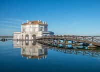
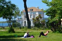
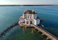
- CASINA VANVITELLIANA
The Casina Vanvitelliana is an evocative little house located on a little island of Fusaro Lake. In 1752 Fusaro area, at the time mostly inhabited, became the hunting and fishing reserve of the Bourbons, who hired Luigi Vanvitelli for the first works for the transformation of the place. When Ferdinando IV ascended to the throne, the interventions were completed by Carlo Vanvitelli, Luigi's son, who in 1782 created the Royal Casino of Hunting on the lake, not far from the shore. This building, known as Casina Vanvitelliana, was used as the residence for important guests, such as Francis II of Habsburg-Lorraine. Inside the building were also welcomed Wolfgang Amadeus Mozart, Gioachino Rossini and, more recently, the President of the Republic Luigi Einaudi. From an architectural point of view, the Casina is one of the most refined eighteenth-century productions, with something that is similar to the conformation of the hunting lodge, designed a few years before by Filippo Juvarra using plastic volumes and large windows. The building commissioned by the Bourbons in fact has a very articulated plan, composed of three octagonal bodies that intersect one at the top of the other, as a sort of pagoda, with large windows arranged on two levels; in addition a long wooden bridge connects the Casina to the lake shore.
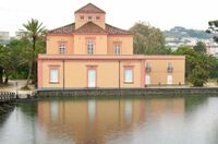
- SALA OSTRICHINA
In 1817, on the shores of Lake Fusaro, a new building called the Ostrichina was built. It was in front of the Casina Vanvitelliana, based on a project by the court architect Antonio de Simone. The building’s name derives from the baskets for oyster farm of the Fusaro lake to which the Ostrichina was connected. In 1853 the building, originally with a central plan and smaller than it is today, was used as a restaurant, and in 1885 it was renovated and reopened to the public. By the end of the 19th century the building was increased by a two-level building, assuming the planimetric "L" shape given by the aggregation of the two bodies subsequently added. Furthermore, the particular planimetric conformation has suggested the creation of a large room with marble flooring that gives grandeur to the unitary space of the room. Today it is not open to the public except on rare occasions for conventions, concerts, exhibitions and public meetings.
- FUSARO COLUMBARIUM
The funerary complex known as the Columbarium in Via Virgilio is located in a public area: it consists of a series of rooms at street level and an underground building of the columbarium type. In the original project the rooms, made of bricks and reticulate, didn’t have a funeral destination but were used as a meeting place for the celebration of the deceased. The construction of the complex has spanned different phases, from the end of the I century. B.C. until the II century. A.C when the definitive complex was built. The latter included rooms on the upper level used for burials and for inhumation. During the III century A.C, in this complex were found 11 funerary epigraphs. The earliest information referring to the Fusaro mausoleum dates back to 1841 when the Kingdom of the Two Sicilies’s architect Carlo Bonucci explored the complex, finding three funerary epigraphs inside burial tombs. After more than a century, in which the site was used as an arsenal and then as a landfill, a new intervention was carried out by a working group coming from the Municipality of Bacoli. They excavated other burials, returning eight other funerary epigraphs that were discovered.
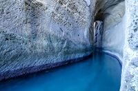
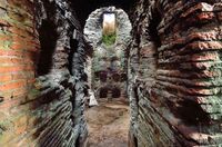
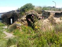
- WATER CAVES
The water caves on the shores of Fusaro Lake are the remains of thermal cisterns from the Imperial Roman age. In the past they were annexed to a Roman villa behind them, in fact they were rich in ornamental paintings and stuccos that are now disappearing. The caves, until 1950 were used as a healing place for local people. The waters that flow from the subsoil of the water caves were considered "miraculous" by the ancient Romans and by the Bourbons, among the first to restore and protect them, in fact, these waters have a temperature of about 40 ° C and are rich in minerals beneficial, similar to those that flow on the island of Ischia, where they are appreciated by tourists. In 1998, the archaeological site was the subject of new investigations, research and redevelopment; an intervention that unfortunately remained incomplete. For years the caves have been in a state of decay but various associations are involved in the protection and relaunch of this important archaeological site.
-
 Cerberus cavern
 -
 Villa Servilio Vatia
 -
 Casina Vanvitelliana
 -
 Fusaro Columbarium
 -
 Sala Ostrichina
 -
 Water caves


Visual appearance and landscape narrative
- Which elements are essential for the landscape character?
- Has the landscape been painted or otherwise depicted, when and whom? Which elements are essential?
- Which narratives exist? Who has written about this landscape or depicted it in some way?
- You can add text and images
The landscape of Bacoli is a very fragmented territory, characterized since always by a strong natural matrix. Fields, agriculture and water make it a fascinating and complex place. Water is the predominant element, present in many shapes: brackish water of the Tyrrhenian Sea, lake water of Fusaro Lake and its tributaries and thermal water due to volcanism. The name “Bauli” was really famous in ancient Rome and it is related to the legend of Hercules. Coming back from his Labours, he left the oxen he stole from Gerione to rest in this place (“boalia” stands for oxen in Latin). In the past there were rumors that a temple was erected in honor of Hercules, named “Bovalio”. Fusaro Lake was known by the ancient people as “acherusia palus”, the mythical swamp of Hell generated by Acheronte river, this name was testified early in the III century B.C. in the poem “Alessandra” by Licofrone di Calcide.
In the past the city of Bacoli was a literary subject for many Roman orators.
Simmaco, at the time of the emperor Teodosio, described Bauli as a peaceful and quiet place, a “locus amoenus”, he wrote:
“I left that place because there were the risk that, if i had became attached too much to the stay in Bauli, I would not like all the other places that i haven’t seen yet”.
Seneca, in the “Epistola 55” of the “Epistulae morales ad Lucilium”, wrote:
“[...] I don’t think it’s wrong the choice of Vatia to spend his quiet senile otium in this place. [...] That’s why I continue to be transported, invited by the coast which forms a curve between Cuma and Servilio Vatia’s villa: on one side the sea, the other the lake, they close the curve to form a narrow passage. [...] There are two artificial caves, that are a great work, large as a vast atrium: on one of them the sun never beats, on the other one it beats until the sunset. A stream, made by sea and Acherusio Lake waters, similar to a canal, passes through a plane trees groove and it is enough to feed the fishes.”
At the same time, the landscape has been painted many times, in every depiction there is always the element of water.
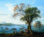
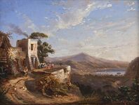
- "Ferdinando IV a caccia di folaghe", Jakob Philipp Hackert, 1783. The painting was commissioned by Ferdinand I of the Two Sicilies to decorate the round room on the second floor of the Casina Vanvitelliana. Hackert took the opportunity to portray a hunting expedition of the king in progress on the lake. The main scene takes place on the stretch of water, there are the Casina Vanvitelliana on the right and a series of boats in the center.
Many expoents of the so-called "Posillipo school" depicted Fusaro Lake area. These artists presented themselves as heirs to the foreign painters who had visited Naples on their Grand Tour in the 1700s, but also as the expression – in the vein of Corot and Turner – of a romantic, emotional and sentimental approach to nature. Some exemples are:
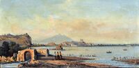
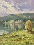
- "Il lago del Fusaro", Achille Carelli, 1850. This oil painting shows a view of the Fusaro Lake. The foreground ruins represent the Water Caves;
- "La foce romana del Fusaro", Giacinto Gigante, 1823;
- "Il lago Fusaro", Anton Sminck van Pitloo, 1820;
- "Veduta del lago Fusaro", Ercole Gigante, 1850;
- "Lago Fusaro", Leon Giuseppe Buono, 1920.
-
 Ferdinando IV a caccia di folaghe, 1783
 -
 Il lago del Fusaro, 1850
 -
 La foce romana del Fusaro, 1823
 -
 Il lago Fusaro, 1820
 -
 Veduta del lago Fusaro, 1850
 -
 Lago Fusaro, 1920


Water and People
Accessibility and usability
- Where are your water areas accessible, and where not? How strong are spatial obstacles preventing access?
On the western side of Fusaro Lake, a beach is entirely dedicated to bathing activities. One part of the beach is completely free from access unlike others dedicated to tourist activities such as private seashores, hotels etc. These are easily accessible and connected to the rest of the city by rail and road infrastructures. Lake Fusaro, which surrounds all coastal area of Bacoli, is directly connected to urban area through Vanvitelliano Park. A shared-use path dedicated to bikes and pedestrians initiates in the park. It only partially allows you to circumnavigate Fusaro Lake’s shores. Eastern Fusaro Lake’s shores host ancient thermal cisterns called Water Caves. Not long ago, they were in a state of neglection and decadence and had become an open-air waste deposit. The Water Caves are easily reachable but cannot be accessed or used thanks to a closed gate which protect the archaeological site. In 2020, a reclamation work began on this important site. It aims to connect this site with the Casina Vanvitelliana on Cuma street and with Fusaro Columbarium on Virgilio street.
- Who is using the spaces and how?
Water areas are mainly used for tourism purposes, especially thanks to summer period’s bathing activities. Fusaro Lake, used for fish and shellfish breeding, is also a tourist attraction thanks to the Casina Vanvitelliana located on a salient islet. This islet is connected to the mainland by a pier that allows you to observe a 360-degree panorama. However, the thermal complex is now almost completely abandoned.


Community Mapping
We have identified around ten stakeholders or social groups on Fusaro Lake territory.
- Social groups:
-Local working class, 54.6% (2011) the trend is stable (data: 8milacensus).
-Local minors, 21.4% (2011) the trend is decreasing (data: 8milacensus).
-Local retired, 24% (2011) the trend is increasing (data: 8milacensus).
-Seasonal tourists, mass tourism is constantly increasing, coastal areas are particularly attractive during summer.
| Needs | Objectives | Power | Capacities | |
|---|---|---|---|---|
| Local minors | Community areas,
Parks, Sportive infrastructures, |
Making their voice heard,
Enjoy their youth, |
Active in associations, | Linked to the power of associations, |
| Local working class | Provincial transport infrastructures,
Local shops, |
Projects should improve their well-being and making their life easier, | Voters,
Capital, |
Mainly linked to political supports, |
| Local retired | Parks,
Local shops, Local transport infrastructures, |
Projects should improve their well-being and making their life serener, | Voters,
Long term inhabitants, |
Mainly linked to political support, |
| Seasonal tourists | Regional transport infrastructures,
Entertainment complex, |
Having fun, | Capital, | X |
- Local stakeholder groups:
-Associazione Percorsi Cumani “organizes cycling events for citizens and tourists to discover the historical and cultural places of the Phlegraean territories and offers support to the Phlegraean municipalities for of cycle and pedestrian paths design and networking” (website: About us).
-Free Bacoli “was created by a group of young people from Bacoli and Monte di Procida who decided to actively contribute to the improvement of their land through initiatives and proposals, and by publicly denouncing everything that political classes try to hide” (website: Chi siamo).
-Diamo a Bacoli “is a political-cultural association made up by Bacoli's children who have decided to bring together their skills to support their territory” (Facebook page). -Il Pappice “is an independent day of political, civil, social and cultural struggle” (website: cos’è il Pappice).
-Local small businesses.
| Needs | Objectives | Power | Capacities | |
|---|---|---|---|---|
| Associazione Percorsi Cumani | More cycling infrastructures, | Making Bacoli a cycle-friendly city, | Specific Knowledge,
Capital, |
Support projects, |
| Free Bacoli (elected civic list) | Culture,
“Projects for the active population”, |
Having a political influence,
Increasing citizen participation for local decisions, Cultural revolution, |
Social Information,
Bringing together individual skills, Political influence, City Management, |
Managing the city,
Social activism, Decision taking, |
| Diamo a Bacoli | Improving life conditions, | Having a political influence,
“Improve our Bacoli”, |
Bringing together individual skills, | “Civil laboratory” |
| Il Pappice | Improving life conditions, | Report anything that is worth it on the territory, | Local journalism, | Online newspaper, |
| Local small businesses | Surviving, | Being profitable,
Being competitive, |
Provide necessary needs, | Mainly linked to political support, |
- External stakeholder groups:
-Città metropolitana di Napoli is the third Italian metropolitan city by number of inhabitants, while it is first by population density.
-Ente Parco regionale dei Campi Flegrei, manages a natural protected area.
| Needs | Objectives | Power | Capacities | |
|---|---|---|---|---|
| Città metropolitana di Napoli | Improving life conditions,
Being nationally competitive, |
Economic growth,
Social results, |
Political power,
Metropolitan management, Finance, |
Financing projects,
Change laws, |
| Ente Parco regionale dei Campi Flegrei | Limit urban expansion and pollution, | Protect the territory,
Conciliate tourism and nature protection, |
Management of the area,
Specific knowledge, |
Financing projects,
Decision taking, |
-
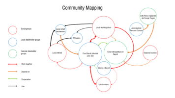 Community mapping

Possible Futures
- Starting from DPSIR model we found three possible scenarios. For each of these ones we carried out SWOT anlysis.
-
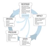 DPSIR analysis

| Helpful | Harmful | |
|---|---|---|
| Internal origin | Strenghts
Closed spaces Presence of local and typical products of quality. |
Weaknesses
Lack of equipment and activities Lack of attractive places Open and isolated areas, they are inaccessible and unconnected There are community spaces only near the lake |
| External origin | Opportunities
Active local associations Mass tourism Masterplan Litorale Domitio-Flegreo |
Threats
Covid pandemic Presence of isolated houses |
| Helpful | Harmful | |
|---|---|---|
| Internal origin | Strenghts
Shared-use path on Spaggia romana street (half-finished) 5.3km of train line and 4 train stations |
Weaknesses
There are only two access points to the city by car Lack of intermodal nodes Green spaces fragmentation |
| External origin | Opportunities
Active association on the territory Mass turism Active mobility development Aquatic transport mode development |
Threats
Intensive traffic Covid Pandemic Soil consumption |
| Helpful | Harmful | |
|---|---|---|
| Internal origin | Strenghts
Presence of 3 archeological sities: Villa Servilio Vatia, The Water caves, Fusaro Colombarium Cultural tourism Presence of numerous cultural heritage in the area (ex. Casina Vanvitelliana) |
Weaknesses
Lack of archeological sities management and enhancement Lack of connection system Polluted water in the Water Caves |
| External origin | Opportunities
Question of attractiveness Seaside tourism Historical identity of the place |
Threats
Covid pandemic Some Villa Servilio Vatia rests are incorporated in a restaurant Unawareness of cultural sities values by local people and consequent uncivilized behaviour |
- Which UN sutainable developement goals are at risk?
On Fusaro Lake area three UN goals are in critical state. Acting on these goals can result to improve greatly life conditions on this area.
Goal 6 - "Clean water and sanitation": the sixth target is at risk because the quality of the waters present in the Bacoli area is seriously polluted. Due to this phenomenon, biodiversity in lakes is running out and fishing activity is collapsing too.
Goal 11 - "Sustainable cities and communities": the eleventh objective is at risk due to the strong urbanization of rural areas that are becoming more and more urbanized. Rapid urbanization involves several issues: inadequate and overloaded infrastructure and services (such as waste accumulation and water and sanitation systems, roads and transport), worsening air pollution and unplanned urban sprawl.
Goal 15 - "Life on land": the fifteenth objective is at risk as human activity has altered almost 75% of the earth's surface, compressing wildlife and nature into a smaller part of the planet. Many animal and plant species are threatened by extinction and the ecosystems is deteriorating affecting the very foundations of our economies, livelihoods, food security, health and quality of life around the world.
- From these three UN goals we have established three main values that should lead our interventions.
Biodiversity and natural resources,
Cultural identity,
Services and accessibility.
-
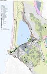
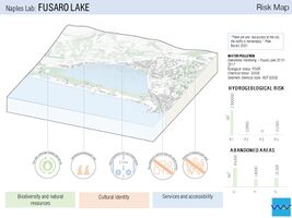 This risk map individuates criteria which could get worse on the territory. The worst case scenario is a situation where numerous of these criteria worsen.
 -
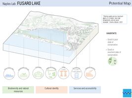 This potential map individuates criteria which could get better on the territory. The best case scenario is a situation where numerous of these criteria are enhanced.


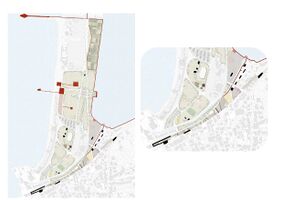
- Three different scenarios have been found, each one of them is a deepening of the “responses” found at the end of the DPSIR analysis.
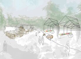
The first scenario is taking advantage of abandoned spaces by converting them into multifunctional spaces for local products sales and by organizing events for the community.
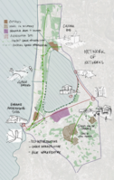
The second scenario is based on a system of relations created from green infrastructures. These could connect parco della Quarantena with frutteto borbonico and even up to Water caves.
The third scenario take form as an archaeological itinerary that brings together, even punctually, the historical and cultural heritage (Fusaro Columbarium, Water Caves, Villa Vatia).
-
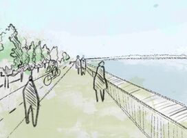 scenario 1: Green infrastructure system.
 -
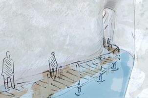 scenario 2: Enhancement of the archeological heritage.
 -
 scenario 3: Community spaces.


Collaborative Goal Setting
Define strategic planning objectives based on the evaluation findings from your analysis
- Historical and archaeological heritage enhancement and conservation making more accessible the water caves and the Fusaro colombarium and by the creation of an organized itinerary connecting the different areas;
- Improve the mobility system, encouraging pedestrian mobility through the completion of the existing pedestrian cycle track around the lake, the making of transverse axes which connect the sea area with the city, the introduction of a an electric tram network and the creation of new roads;
- Improve the tourist-accommodation system creating a kind of transect zone in the ex industrial area and redevolping the coastal area;
- Enhance and safeguard agricultural activity and traditional crops creating a system of urban gardens, outdoor and indoor food market, spaces for the consumption of local products;
- Creation and enhancement of fruition spaces projecting urban parks, outdoor sports equipment, landscape observation points;
- Expand and improve the system of equipment and services such as schools, existing parks, creating green parkings;
- Urban soils reuse regenerating abbandoned buildings and areas.
Ideally, involve the community of your living labs into this process To formulate the objectives of the plan we considered necessities of both local actors and the living lab community.
- Option 1: Creation and enhancement of fruition spaces
Students: “That’s a good area where you can relax by doing sport!” Old People: “Nice place to seat, converse and enjoy the view.” Children: “We can play in an open space with other children and have fun in the nature without risk!”
- Option 2: Enhance and safeguard agricultural activity and traditional crops;
Farmers: “Country fairs can be organized to promote products, really cool for us!” Old People: “It would be nice enjoying the local products of our agricultural tradition!”
- Option 3: Improve the mobility system, encouraging pedestrian mobility;
Young People: “That’s such a good solution because it allows us to movin’ on foot or with other alternatives to the car.” Old and disabled people: “Improving accessibility would be a way to make it easier for us to visit all the places without obstacles or risks.”
- Option 4: Historical and archaeological heritage enhancement and conservation;
Students: “It is very important for us to have direct experience with the topics we face in our studies.” Tourists: “It would be interesting to visit and know the historical spots through a guided itinerary!”
Link back to your original targets from section one and the Development Goals
- Goal 6 - "Clean water and sanitation": restore polluted water systems of the sea, the lake, the mouth and the thermal waters;
- Goal 11 - "Sustainable cities and communities": enhancement of the existing green areas using these last ones to create services for the community with a sustainable approach;
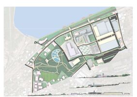
Spatial Strategy and Transect
- translate your strategic goals into a vision
- develop a spatial translation of your vision
- exemplify your vision in the form of a transect with concrete interventions
-
 Spatial translaton vision
 -
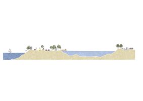 Urban Transect
 -
 Link
Link -
 Requalify
 -
 Develop
 -
 Restructure
 -
 Traverse


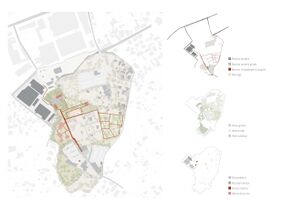
From Theory of Change to Implementation
- For implementing your vision: Which partnerships are needed? Which governance model is required?
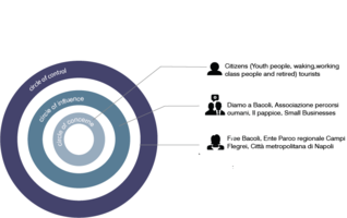
To carry out our various projects, it is necessary to ensure that the inhabitants and the various stakeholders are involved in the various stages of completion. Informing residents is not enough. They must be consulted at each stage of the territory transformation process. In addition, conflicts of interest are likely to arise, so it seems necessary to bring together the various stakeholders and residents to validate the main orientations of the project. Our governance model should try to create connection between the three entities or three circles (circle of concern, circle of influence and circle of control).
In the circle of concern we have identified seasonal tourists and citizens who could be individuated as minors, working class people and retired.
In the circle of influence we have identified some associations such as Associazione Percorsi Cumani, Il Pappice, small businesses and Diamo a Bacoli which have also a political action.
In the circle of control we have identified the Città metropolitana di Napoli, Ente Parco regionale dei Campi Flegrei and Free Bacoli which is the political power in place.
This step is crucial because it will also make it possible to identify stakeholders’ specific interests. Once the main orientations have been validated, participatory workshop sessions will be held in small mixed groups (from the tree circle) to bring together individual opinions and suggestions. The micro-scale scenarios will be reworked internally and then communicated to all participants. In accordance with our methodology, different scenarios will be presented, and a vote will be held. Obviously, the circle of control will be the last to choose the scenarios and make the financial choices.
-
 Stakeholders influence

- Who needs to act and how? Draw and explain a change/process model/timeline
Monitoring an urban regeneration project is a complex process, especially when it comes to integrate various stakeholders. It includes urban planning tools, financial programs, and financial instruments. It’s a process that involves monitoring and feedback phases. In order to follow a voluntary procedure, it is necessary to forms partnership between institutional entities, private actors, associations and local communities. It will structures relationships between stakeholders even if they will use their own competences to help the implementation program. The continuous monitoring of implementation phases is making possible to intervene in a timely and effective manner. However, introducing not deliberate changes may be necessary during a complex process in order to ensure the objectives set.
-
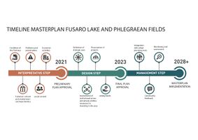 Timeline masterpkan fusaro lake and phlegraean fields

- Which resources are needed? On which assets can you build?
Our management program based on theory of change required help and recognition from the circle of control. Without a full support from Bacoli’s city hall our management program will be cost effective, and the urban regeneration program will lag. However, if the management program is successful the benefits will automatically improve further urban changes. Indeed, participative workshop and communication conference lead to strengthen relationships between stakeholders and citizens.
References
https://www.tuttitalia.it/campania/59-bacoli/
https://bacoli.etrasparenza.it/
https://programmazionestrategica.beniculturali.it/progetto/campi-flegrei-baia-fra-terra-e-mare/
http://www.regione.campania.it/regione/it/tematiche/piano-territoriale-regionale-ptr
http://sit.cittametropolitana.na.it/cartografia_tecnica.html
Process Reflection
- Reflect in your intercultural and interdisciplinary team on the outcomes of your study
- Which limitations were you facing?
The main constraints we have had are due to the covid-19 pandemic. We were unable to conduct a site visit at the start of the semester and therefore fell behind in understanding the site. In addition, we did not meet any inhabitants of our study area and we only know their point of view from the help of the various stakeholders we met.
- What have you learnt from each other?
Above all, we have learned to listen to each other. Indeed, an urban regeneration project requires taking into account not only factual information but also subjective opinions and informal orientations. Also, it was through the many discussions that we had that we were able to move forward. However, the covid-19 pandemic has changed our working habits, we have never had the opportunity to work with tracing paper and we have always had to express ourselves in words and more rarely in drawings.
- What did you learn in the Living Labs?
With the living lab we have developed our theoretical and practical knowledge concerning the urban regeneration of coastal spaces.
-
 '
' -
 '
'

