Lacul Fundeni Team 1 WAVE Living Lab 2021
>>>back to working groups overview
| Area | 34.64 ha | |
| Place | Bucharest | |
| Country | Romania | |
| Topics | please enter the main topics of your living lab | |
| Author(s) | Argint Ana-Maria, Andone Ioana, Bacale Tania, Banica Mihaela,Ciocan Andi and Dogeanu Alina | |
 | ||
Rationale
- Why do you think this case is relevant? What is your hypothesis considering the landscape challenges?
- Format: 3-4 sentences
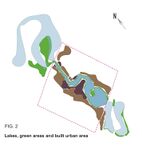
Location and scope
You can edit this map with the map editor
Water as a natural system
Geomorphology, typologies and dynamics of water areas
- Describe the water areas of your area in the contxt of the wider water system
Colentina springs from the hills of Târgoviște (from the Sotanga-Doiceşti area), is a tributary of Dâmboviţa and covers a route of 98 km, of which 37.4 km on the area of Bucharest. In the entrance area of Bucharest, Colentina forms a chain of natural lakes: Mogoşoaia, Băneasa, Herăstrău, Floreasca, Tei, Plumbuita, Fundeni, Pantelimon. Based on studies completed in 1930, the work of rehabilitating the lakes of Colentina and transforming the swamps in the northeast of the capital into picturesque and healthy places began 2 years later. Thus, the staging of the works included: stage I - construction of the artificial reservoir Buftea (completion September 1934), stage II - arrangement of Băneasa and Herăstrău lakes (completion June 1935), stage III - arrangement of Floreasca lake (completion in September 1936), stage IV - arrangement Tei Lake (completed in November 1937) and stage V arrangement of Fundeni lake (1938-1939). Later, the Pantelimon and Cernica lakes were arranged.3 Salba lakes are a real oasis of greenery and oxygen source, contributing to the improvement of the local climate and the reduction of pollution by absorbing a significant amount of dust suspended in the air. [1]
- How does water appear in the landscape of your living lab? What types of water areas are common?
The Fundeni 1 area represents an anthropized lake determined by the Colentina River. When stormwater discharges are high, the flow of the river increases and the near areas can become unstable. The bluff lines are also anthropized so the water will not flow into the living areas. In geomorphological terms, we can describe Fundeni 1 as a floodplain for the main Colentina river channel.
- Please identify the water bodies' catchment areas, tributaries and floodplains
Catchment areas to N-V Barajul Tei (Fig. 3) and Barajul Stăvilar to N-E. The areas where water accumulates before reaching the Tei - Fundeni (1st segment) are the Tei Dam to the N-W and the Stavilar Dam to the N-E. The capacity of this Fundeni Lake is 2.5 million cubic meters in an area of 120 Ha. The dam’s height is 9.00 m, the type is PO (Homogeneous earth ). The total volume at NME (million cubic meters) is 1,370, the attenuation volume (million cubic meters) is 0.470 (Fig. 5), and the use is of type V (flood protection), P (fish farming), R (leisure, recreation), X (other uses that do not fall into the mentioned types). 1936 plans to systematize and rehabilitate the northern lakes of the Colentina River aimed at designing dams and canals along the river not only in terms of leisure and health of city dwellers, but also in terms of industry, so we have in the studied segment the Thermal Power Factory in connection with the Pantelimon Canal in the NE, And NV we have the Hydroelectric Factory.
- Which dynamics do these water areas have?
Fluid dynamics is a scientific discipline that deals with fluid flows. It is a part of fluid mechanics that falls into two categories: Hydrodynamics and Aerodynamics. Hydrodynamics of the first part of Lake Fundeni with a length of 1.8 km + 800 m of island from which accessible 1.5 km presents a namesake course of water flowing through a narrower channel to the other lake. We have a 500-meter splash, which ends abruptly in a wasteland, which was unfortunately "invaded" by waste. Panorama to the neighborhoods Colentina and Plumbuita is impressive, the park being arranged right on one of the terraces. From here, to us we head towards the Obor-Pantelimon railway and towards dam, we have to sneak past the houses Roma, on a road affected by manure from the surroundings. Before the railway, we arrived in the little "frățiorul" of the park I left behind behind, another smaller green space called "Walls between the Living", also arranged in 2012 and baptized after the homonymous street at the end of which it is located.
- Have there been any flood events in the past?
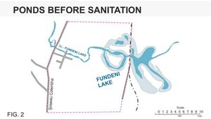
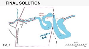
Historic floods along the Colentina River occurred in July 1970, July 1972 and July 1975. The most important flood was that of 1975 in the Colacu locality, but none of the events did not take place in the Fundeni Lake area, but was taken into account systematization and remediation of the Colentina River and lakes, so the segment studied Lake Fundeni, subsequently benefited from a systematization that designed the Tei - Fundeni Canal to connect Lake Floreasca with Lake Fundeni and avoid possible flooding(Fig. 1, 2) The cross section and at the bottom it has slopes of 1;5 m; 1;4; 1;2; and 1: 1,5 reaching a crown width of 44,00m. The difference between Floreasca - Tei and Fundeni is 9,00m and downstream it's 2,00m. The construction of the Tei-Fundeni Channel was planned for the rectification of the Colentina River. The length of the channel is 3 km.
-
 Long and cross profile of Lake Colentina River
 -
 Ponds before sanitasion
 -
 Ponds_after_sanitation_final_solution


Water as a living space
- Which habitats can be found in and along the water areas of your area?
Lake Fundeni 1 is part of the chain of lakes of Colentina. The whole area is characterized by the same habitats, although around the studied area there are fewer planted areas and more spontaneous vegetation than in other areas of the Colentina River.
The vegetation and fauna of the Colentina River on its route before and after the exit from Bucharest includes creatures specific to the aquatic and plain area. It includes several species of fish (artificially introduced), including dwarf catfish, crucian carp, perch, bream, etc., a number of birds such as wild duck, night heron, rodent, gull, brown cormorant, stork, swan, etc. as well as amphibians and reptiles such as the Romanian aquatic turtle (protected species), the water snake, the great lake frog, etc. The green spaces around the water include plants such as frogs, firs, reeds, rushes, lentils, wild daffodils (protected species), specific trees, especially willow, etc. During the summer, the lakes show the phenomenon of algal blooms due to the high concentration of phosphorus and nitrogen in the water due to the discharge into the lake of insufficiently treated wastewater from the riparian localities, which damages the flora and fauna in the area. [4]
- How is the water quality in your water areas?
According to the analyzes performed, in relation to the legal provisions for drinking water, the level of turbidity registered for Fundeni Lake is equal to 10 and exceeds the allowed limit. This reduces the amount of light that can enter, resulting in serious consequences for the aquatic habitat. From the point of view of suspended solid particles, Fundeni Lake is part of the normal parameters, thus not representing a danger to the environment and biodiversity. The concentration of phosphate ions in the collected water samples has a result that falls within the accepted limits. The lakes formed along the Colentina River do not face serious problems of contamination with pollutants, but there are certain pathogenic germs that indicate that the water has been contaminated with feces upstream neighbors. There is an exceedance of the maximum permitted values for phosphate and TDS which may be a danger to the health of aquatic life or the danger of excessive consumption of fish, as these accumulated in animal tissue tend to transfer to the human body. [5]
- Which areas are still natural, which are urbanised/artificial?
The areas around the lake are both natural and urbanised. The natural areas are represented by the spontaneous vegetation which is situated around the water area. Fundeni lake is surrounded by apartament housing, segregated community houses, villas and garbage dumps.On the left side of the canal is a food market and recently inaugurated a pedestrian walkway over the canal.
- Are the rivers permeable for fish or blocked by artificial elements?(approx 200 signs)
The natural environment favors the development of human settlements. Lakes and green spaces are true green oasis and also oxygen sources for the climate balance and refreshment of the polluted atmosphere of the city. The water quality of Fundeni lake does not meet quality standards, which is why it cannot be used for domestic purposes. This is due to the direct discharge of waste water into the Colentina River to industrial plants upstream of Bucharest. On the other hand, the Colentina River lakes have not been dredged for more than 30 years, which has led to the accumulation of large quantities of unhealthy sludge. Alluvial deposits transported by the water that feeds the lake have led to the excessive development of the aquatic vegetation and, as a result, the impossibility of recreational activities. The natural environment of the area was anthropized for economic and spatial development of the neighborhood. Fundeni lake is surrounded by apartament housing, segregated community houses, villas and garbage dumps. This water area is only attractive to fishermen who have to carry out their passion in an unhealthy and desolate environment. The process of acid deposits accumulation begins by enrolling three pollutants into the atmosphere which, in contact with sunlight and water vapor, form acidic compounds. During precipitation the acid compounds are deposited on the ground or in water. Otherwise, gases can cause dust or other particles to reach the ground in dry form or in surface water, and even underground water. Acid deposits affect surface water, groundwater and the soil, with major damage to lakes and fish fauna, forests, agriculture and animals.
- add 1-2 graphical representations to the image gallery, you can add more if you like
-
 Context analysis_Lake fundeni
 -
 Water quality
 -
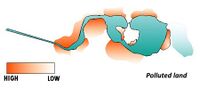 Polluted areas


Blue and Green Infrastructure
- What are the major potential elements of a green/blue infrastructure network? Are these likely to change/disappear? Why is that?
The major potential elements of a green/blue infrastructure network based for Fundeni lake are public space networks such as “Râul Colentina” park which create spatial integration for mixed urbanization with the lakes chain for sustainable development aiming to connect it to its wider landscape of the city and it consists of an interconnected network of green spaces, which provides a favorable habitat for native species, contributes to the maintenance of natural ecological processes. The green/blue infrastructure plays an essential role moderating the imbalances generated by buildings and transportation. The connection between these elements and the steady growth in urban residents increase accessibility to green open spaces improving the connectivity and functionality of the city.
- You find my background material on green infrastructure in our reading list
- add 1-2 graphical representations to the image gallery, you can add more if you like
-
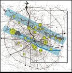 Blue and Green Infrastructure, Bucharest

Water as a cultural space
Land use and water
- map the land uses along your water areas: settlements, infrastructure, agriculture, resource extraction, natural areas, energy production...
- maximum unevenness of the terrain on the northern shore up to a distance of 100 m: 3,70m - maximum unevenness of the terrain on the southern shore up to a distance of 100 m: 10,70 m The surfaces of the Fundeni lake on the territory of Bucharest: lake basin areas in hectares: 123 Ha Small-scale interventions of everyday life - transverse retraction
- describe in particular the historical evolution of land use pattern, please make use of historical maps
Fundeni, subsequently benefited from a systematization that designed the Tei - Fundeni Canal to connect Lake Floreasca with Lake Fundeni and avoid possible flooding in the 1936 and right after the solution stayed until today as it was designed. (Fig. 1) The construction of the Tei-Fundeni Channel was planned for the rectification of the Colentina River. The length of the channel is 3 km.
- description evolution, status quo and driving forces, is the land use likely to change? Why is that? (approx 200 signs)
The evolution can be possible if we pay attention to the well known model with the Analysis, method, Concept and then can be applied the intervention. The elaboration of an analysis method, applied to the studied urban area adjacent to Fundeni lake and Colentina river, can orient the studies towards the identification of specific elements and common elements that determine the knowledge of general characters and the possibility of intervention in the context of integrated city development. Looking at the scheme (fig. 1) we can notice the difference after the systematization of the Colentina river and the benefits brought later to the area due to this intervention. Thus, in 2021, regarding and analyzing the site, we can elaborate a suite of principles that would help the area to be capitalized. Urban landscape: - Interaction with the small scale landscape Circulations: Segregated pedestrian alleys for running and cycling, connection, optimal accessibility from multiple areas built to green alveoli and the main natural element water Tourism: can be mentioned because it is an area with a strong identity. Increasing the tourist attractiveness by introducing in a tourist circuit, revaluation, presentation and introduction of valuable areas of monuments in the city, creating new objectives and cultural circuits The area that is the object of this zonal urban plan is comprised between the riverbed of the Colentina river, the Colentina road and the collective housing complex. The land was previously occupied with individual houses with parcel of land that were demolished for the regularization of the Colentina river and for the realization of the mentioned collective housing ensemble. some of the plots in the area have started to be resold by the former owners, but their dimensions and conformation do not allow the realization of a residential complex corresponding to the current comfort requirements in the image. In these conditions, the mayor's office of sector 2 launched theorder for the zonal urban plan to solve the following problems: capitalization with maximum use for the inhabitants of the neighborhood included in the zonal urban plan, the land between the water mirror of colentine and a group of collective dwellings with a population numerous. (Fig 3) The administration of the territory and implicitly of the city is an act of the local administration with which other urban actors with interest in the development of the area (NGOs, investors, specialists in architecture and urbanism and related professional associations, inhabitants of the area) must be involved in the regeneration process of evolution.
- add 1-2 graphical representations to the image gallery, you can add more if you like
-
![Colentina River and Fundeni Lake[6]](/images/thumb/3/3b/Colentina_River_and_Fundeni_Lake-Water_as_a_cultural_space.jpeg/200px-Colentina_River_and_Fundeni_Lake-Water_as_a_cultural_space.jpeg) Colentina River and Fundeni Lake[6]
Colentina River and Fundeni Lake[6] -
 add a caption
 -
 add a caption
![Colentina River and Fundeni Lake[6]](/index.php?title=File:Colentina_River_and_Fundeni_Lake-Water_as_a_cultural_space.jpeg)


Cultural and spatial typologies of water areas
- Which spatial patterns have evolved in relation to your water areas?
The main pattern that was formed as a result of the evolution of the lake is that of growing abundant vegetation in the sense that many "bare" spaces are today covered with wild grasses, shrubs or low trees.
- What is the role of water areas within the overall urban morphology? (approx 200 signs)
-We can say that the water area helps the ecosystem and provides a morphological perspective of nature in the urban space, a green oasis among the habitable concrete.
- add 1-2 graphical representations to the image gallery, you can add more if you like
-
 add a caption

Sacred spaces and heritage
- Which places/elements hold cultural value and to whom?
There are no specific cultural-historical identity elements relevant to the population or evidence of certain stories related to the Fundeni Lake. In a survey related to Identity value elements of Lake Fundeni 1, respondents reported that they were more emotionally linked to their own memories created here (28,6% of respondents). It means that there is a connection between individual and space which is more personal than collective or linked to certain historical and cultural events. No one was referring to myths or stories related to Fundeni lake. Respondents also consider serenity (42,9%) as a key element adding personal value to the place. The urban landscape (21.4%) is also valuable for individuals.
- You may add a map and some images, please also explain in your caption why these elements are valuable
-
 add a caption

Visual appearance and landscape narrative
- Which elements are essential for the landscape character?
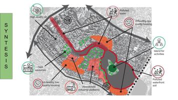
The essential elements for the characterization of the area are: the individual living areas, the shores of the green, non-anthropized water, the island in the center of the lake where events are still held and the former abandoned industrial platforms. The latter are sources of risk, being today vacant land on which garbage is dumped
- Has the landscape been painted or otherwise depicted, when and whom? Which elements are essential?
The development of the lakes began in 1933, when the birth of the landscape began. Since the former colentine swamp, with the development of the city but also with the development of industrial areas, there is a need to use land and resources in a more optimal way. The landscape was empty for a long time, with a low density of houses in the south in 1935. Around the 60's we find dates about houses in the north of the studied area. Industrial areas developed around the 70's. Currently they are abandoned, resulting in large open spaces or with former industrial platforms. The occupation with houses was made in the north of the area with slightly higher densities, starting with the collective housing. The landscape today is characterized by vast, empty areas, front interruptions and a discontinuous image.
- Which narratives exist? Who has written about this landscape or depicted it in some way?
The area is mentioned in various articles on Romanian newspaper sites such as MediaFax, Ziare.com and in articles on blogs or community sites such as my dear Bucharest. More official sources are the town hall website, the town hall's facebook page and the urban plans.
- You can add text and images
-
![Bucharest 1966- Fundeni Lake[7]](/images/thumb/5/59/Bucuresti_1966_Colentina_1.png/171px-Bucuresti_1966_Colentina_1.png) Bucharest 1966- Fundeni Lake[7]
Bucharest 1966- Fundeni Lake[7] -
![Bucharest 1978- Fundeni Lake[7]](/images/thumb/6/63/Bucuresti%2C_1978-_Colentina_2.png/200px-Bucuresti%2C_1978-_Colentina_2.png) Bucharest 1978- Fundeni Lake[7]
Bucharest 1978- Fundeni Lake[7] -
 Structural functions
![Bucharest 1966- Fundeni Lake[7]](/index.php?title=File:Bucuresti_1966_Colentina_1.png)
![Bucharest 1978- Fundeni Lake[7]](/index.php?title=File:Bucuresti,_1978-_Colentina_2.png)

Water and People
Accessibility and usability
- Where are your water areas accessible, and where not? How strong are spatial obstacles preventing access?
Throughout the first segment of Lake Fundeni I noticed 2 access roads for the public, degraded with a fairly high risk of injury. The others are located within the plots being private and also neglected. Despite these, I noticed that a good view of the lake can be possible from the terrace of the Floreasca club. The main obstacles to getting close to the lake are the thick layers of wild vegetation and the waste left by humans
- Who is using the spaces and how?
At the same time, the space, with an extraordinary potential, is not used because it is very difficult to reach and very dirty. It is rare to see a citizen trying to fish or photograph the area, but in the case of fishing he leaves disappointed because the water quality does not allow the existence of an underwater biotope. Instead, I noticed that some homes that have access to the lake, have boats on the side of the harbor that probably walk on the lake.
-
 Accesibility_Lake_Fundeni_1

Community Mapping
What is to be mapped here?
- Social groups from within the community, for example the youth, kids, students, parents, the retired etc. Typically, these groups have specific needs, which you can also make explicit on the map. These people might not be organized in any way, but they are usually present in the context you are observing
The social groups found in the area of Lake Fundeni 1 are, on the one hand, few inhabitants and people in transit. One observation on social categories on the ground is the definition of a boundary between a segregated community living in the lower part of the lake and the inhabitants of the cliff. In general, these social categories do not meet, forming part of 2 different areas - the lower have a small and isolated community, live in illegally built houses, and those in the cliff are the people who usually live in nearby blocks of flats. Differences still exist in the north vs. south, the south being poorly developed and on the northern shore there are newly developed buildings and villas. The needs of these communities are not met, with poorly exploited leisure areas and few educational, commercial facilities. Leisure areas are also poor quality compared to the context, as these areas are growing independently in the lake area. The lake area represents a cheap area for homes and investors precisely because of the lack of exploitation of the image of Lake Fundeni, and is now treated as a landfill with a huge pollutant risk.
- Local stakeholder groups: these groups are organized in one or the other way. They only exist within the community context you are observing. For example: the local community center, local churches, local interest groups, the landowners, small businesses and retailers
Along the studied segment and even the neighborhoods, they are represented by the University Lumina of South-East Europe, Colentina Stadium, the island where events are organized, collective residential neighborhoods, residential neighborhoods with individual houses, hotels, companies, parks etc.
- External stakeholder groups are not necessarily present in the environment you are observing, but they may have strong stakes and interests. These can be local authorities, politicians, associations, care services etc.
The external stakeholders are the Mayor's office of sector 2, The City Hall, the urban planners, the architects, real estate investors who want to build collective housing, specialized university professors from “Ion Mincu”, administrative organizations of Romanian waters.
- For each group, you may identify their needs, objectives, power and capacities
For the stakeholders such as the Mayor's office of sector 2, The City Hall, the urban planners objective is to support improving community involvement in city decision making and also provide the basis for the development of urban regeneration interventions, identification and implementation of projects for the lake. The real estate agents develop the real estate market in a non-sustainable way which can be very harmful for the area, the main interest being in real-estate development and urbanification, not being able to preserve the ecosystem integrity
- You may also identify gaps and power conflicts
The main power conflict for the area is the use of the land by the stakeholders. The problem is generated by the private sector, which has various residential projects in the vicinity. Unfortunately, there is still no coherent project to restore the entire area and public-private partnership to use the potential of the lake area leading to the area lowering its potential.
- Please try to redepict these elements in an integrated way and in relation to your water landscape. What is the relationship between these groups? Are they close or distanced from each other? Who is more powerful? Which voices are hardly heard? Do they have any shared concerns?
The power conflict that is affecting the water landscape is that the area does not have a protected status. Although the area has the potential to grow and contribute to the community and city, the real estate agents are invested in taking opportunity of the land and profiting from it's potential, degrading the urban and water landscape.

Possible Futures
In the analysis, we identified as main drivers the land and natural resources, natural habitat, fishing, population growth, built-up funds and car traffic. The main pressures are pollution, increasing car traffic, changing the destination of land, the expansion of road infrastructure, the lack of correlation between urban infrastructure and the expansion of the built fund, climate change and waste of resources. As a state we have a high degree of pollution in air, soil and water, the land use, the inadequate use of field resources and a natural habitat affected. The impact on the area consists of the decline of aquatic life, a chaotic real estate development and a result in the degradation of water and soil due to pollution. In response to the protection of the area we need to have a responsible real estate development, high-performance and ecological urban infrastructure, recycling systems and reduction of water consumption, ecological education, improvement of water quality and increased vegetation.
From the last time we analysed the lake, we got these four narrative scenarios.The worst of them are in the left of the picture bellow. When the society is connected but the natural part is collapsed, we notice a rapid urbanization, no place for the ecosystem. The degree of pollution is increased due to the large number of people who would come here. Also for the development of the economy, we observe many new, tall constructions that do not take into account the environment and even if they are related to the lake, they damage its image and affect the ecosystem. In the second case, when the ecological and social parts are both fragmented, collapsed, we notice that we still have some residential areas, but we also have some problems. The former abandoned industrial areas would become active, damaging the urban image, but also causing environmental pollution.
-
 Narrative scenarious
 -
 Syntesis
 -
 D.P.S.I.R. Analysis


Collaborative Goal Setting
The main objectives are the rehabilitation and flowering of the area by obtaining
-Healthy soil and water for a healthy life
-A system that provides goods
-Increased degree of greening
-An image attractive to investors, community and tourists
-Improved basic infrastructure in the new neighborhoods
-A vivant space for the community
-
 Objectivs

Spatial Strategy and Transect
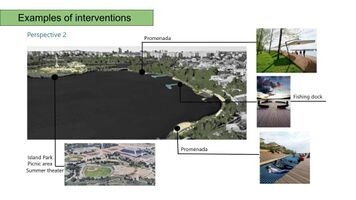
The vision shows the Fundeni 1 Lake area completely changed from the currently offered image. The entire lake is cleaned and serves as a natural habitat for a number of species of fish and birds. The banks of the water are arranged as promenade cliffs with bike lanes and pedestrian alleys. These alleys have continuity, taking place on the entire shore of the lake. On the southern shore there is a jetty that serves for walks on the lake, and on the northern shore there are pontoons for recreational fishing. The island, the distinctive element of the area, is arranged as a picnic area and summer theater. The vacant land is arranged as a park and a small surface serves as an urban garden. Soil pollution no longer exists and garbage has been cleaned, and new waste storage spaces prevent others from appearing. The old ruins of the industrial area have been transformed into a low-rise residential neighborhood that offers a view of the lake. The connection between the two banks is made with the help of two green bridges. Thus, the area presents a pleasant urban image and a healthy environment both for the lake habitat and for the community..
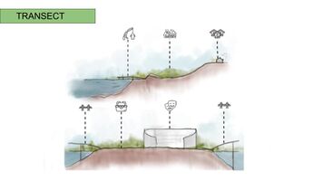
As we know, the transect is a land section that fits several habitat types. By sectioning our study area along the island - the most important source of land , we represented the combination of the anthropized and natural areas of Lake Fundeni. Part of the proposed interventions are thus visible in the current context. In the northern area, the current housing areas are present, but also the new infrastructure connecting the streets and the island - much more accessible and environmentally friendly. On the north shore, we propose a fishing zone, pontoons, but also a promenade alley. Among our proposals is the cycle lane mentioned in the vision, which is an important resource for leisure and accessibility By linking us with the future residential areas proposed by the public administration, we have created some areas for the communities that are coming up, but also for the existing ones. These areas are: An urban Community garden, an urban forest and some sports grounds. The island, as I said earlier, is one of the best ground resources. We have tried to make an intervention as easy as possible that does not affect the natural environment through water, soil or even noise pollution. Inside the island there are oases of serenity -- the summer theater, the picnic area and a green buffer zone made of tree-lined strings.
The island is connected, both in the north and south, to the shores by two pedestrian bridges made out of sustainable materials, which complement the natural landscape area and increase accessibility between the north shore, the island and the south shore.
With our proposal, we want to cover both the social-economic and the natural part, resulting in a sustainable project.
-
 add caption here
 -
 add caption here
 -
 add caption here


From Theory of Change to Implementation
We have found that the needed process for advancing the vision consists in strategies that will not only prevent further degradation and will also fully restore the lake in order to recover its full capacities.
As a final reflection of our process so far we give an outlook of how we may involve the community over the next time. Thus, we made a timeline for the development of projects and interventions and how we could involve the community in each of the processes. In the beginning of the project we would like to address a questionnaire to the public to understand their needs and desires. For the proposal variants and the implementation of the project, we may have discussions with the community and make a strategy together. The community can be physically involved in some of the projects. When the intervention will be completed, we would like to hear people's voices again and to receive feedback. And for a sustainable intervention, we want to sustain the project also implying the community with some activities and events. The masterplan focuses on the interventions on the lake shores, the north-east and south-east area. The northern shore has a distance of 1 and a half km of promenade and pontoons, meant to strengthen the relationship between visitors and the lake. On the south-east coast there are almost 2 km which includes promenade, pontoons, a park with an area of almost 5 hectares and an urban garden that will encourage sustainability and collaboration between the inhabitants of the area and even a harbour for light boats. Therefore are two green bridges with lots of vegetation, proposed to create the connection between the northern and southern shores.
Are also proposed in the next stage of development new residential projects in the south-western area, capitalizing on the economic sector of this area.Their construction will be possible provided that distance would be respected (keeping a sufficient distance from the shore of minimum of 100m ).But the priority is the shores of the lake, by arranging them, creating connections between north and south, cleaning the water and increasing the greening of the area. Some of the main projects are: Rehabilitation and construction of waste-water treatment plants, which are actions for cleaning the Fundeni lake basin. Modernization of existing technical and municipal networks. Construction of a harbour for leisure and fishing pontoons. Organizing cultural activities - summer theater; awareness campaigns for the population regarding selective waste collection. Greening program by increasing the surface occupied by the green area-arrangement of new green spaces and protective curtains. Construction of accesses to the lake cliff, of parking lots to serve recreational areas. Improving the urban image and Construction of alleys for the promenade; Construction of a park and urban gardens
-
 add caption here
 -
 add caption here
 -
 add caption here
 -
 add caption here
 -
 add caption here


References
- give a full list of the references you have used for your case
[1]: Local development strategy 2016-2025 of Sector 2, Bucharest- "Sector 2- Strategie de dezvoltare locala 2016-2025"
[2]:
[3]:
[4]: Claudiu Sfetcu, Apele Romaniei- Salba de lacuri din jurul Capitalei https://www.independentaromana.ro/apele-romaniei-salba-de-lacuri-din-jurul-capitalei/
[6]: Proiecte, studii și realizări ale Universității de Arhitectura și Urbanism “ Ion Mincu” - C.C.P.E.C.
[7]: https://fostulbucuresti.github.io/#15/44.4273/26.0853/
Process Reflection
- Reflect in your intercultural and interdisciplinary team on the outcomes of your study
- Which limitations were you facing?
- What have you learnt from each other?
- What did you learn in the Living Labs?
- What would you do differently next time?
- You can also use diagrams/visuals
- 250 words text