Lacul Fundeni Team 2 WAVE Living Lab 2021
>>>back to working groups overview
| Area | Fundeni 2 LAke | |
| Place | Bucharest | |
| Country | Romania | |
| Topics | please enter the main topics of your living lab | |
| Author(s) | MILEA Alexandru-Gabriel, IREMIA Silvia, ANDRA BUrz | |

| ||
Rationale
- Why do you think this case is relevant? What is your hypothesis considering the landscape challenges?
- Format: 3-4 sentences
Location and scope
Water as a natural system
Geomorphology, typologies and dynamics of water areas
- Describe the water areas of your area in the contxt of the wider water system
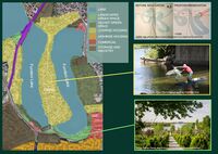
In Romania, the running water system it spreads radially due to the relief configuration, the main river basins on the territory of Romania being the Danube and the Black Sea. The main flowing waters springing from the Carpathians have a longitudinal profile characterized by large slopes in the mountainous region, smoother in the region of hills and foothills and very smooth in the plain region and have as main basin of discharge the Danube. Making a close up to our water area, it is located in the southern region of the country in the Romanian Plain, more precisely in the Bucharest Plain and belongs to the river basin of the Argeș river. In this context, starting with the municipal context, the water body we are analyzing is located in the Pantelimon neighborhood, in sector 2 of Bucharest. Lake Fundeni is an anthropic lake arranged on the river Colentina and is part of the chain of lakes within city. In turn, the Colentina River springs from the Targoviste hills and together with Pasărea River, is a left tributary of Dâmbovița, which in turn is a tributary of Argeș, a river that flows into the Danube basin. Colentina springs from the hills of Targoviste, it covers a route of 98 km, of which 37.4 km on the area of Bucharest, representing the main hydrographic axis that crosses Sector 2. On this river, from upstream to downstream in a system of chained water bodies, between Buftea and Cernica were arranged 15 lakes, of which 10 lakes on the administrative territory of Bucharest. The existing ponds along the valley were extended and transformed into artificial, recreational lakes, which changed the natural flow regime.
- How does water appear in the landscape of your living lab? What types of water areas are common?
Bucharest is located on the banks of the Dâmbovița River, which flows into Argeș, a tributary of the Danube. Lakes are the most common types of water in Bucharest - of which the most important are Herăstrău, Floreasca, Tei and Colentina - are located in the north of the city, along Colentina River, a tributary of Dâmboviței. Lake Fundeni is an artificial lake created by man on the Colentina River. The lake chain of the Colentina River has been created since 1936, by damming the river and rehabilitating the swampy riverbed. The dams are of the homogeneous earth dam type, having the upstream facing walled with concrete slabs, and the downstream facing grassed.
- Please identify the water bodies' catchment areas, tributaries and floodplains
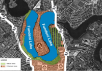
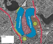
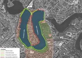
Fundeni Lake is situated along Colentina River and is preceded by Colentina Lake and followed by Dobroești Lake. The Colentina River has as tributaries three rivers: Baranga, Crevedia, Valea Saulei. The entirety of the lake is 88 hectares and its catchments and floodplains are in its northern part of the lake and surrounding the inner island, asspecially in its southern, due to the slope of the terrain.
- Which dynamics do these water areas have?
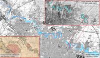
The dynamics of these water areas around Fundeni Lake have undergone significant changes from the wetlands around the Coeltina River that can be seen in map done in 1790 by Colonel Specht and Capitan Hora von Otzellowitz to the well formed banks that can be seen in the Romanian military map done at the beginning of 20th century and furthermore in 1976 soviet maps we can observe the consolidation of the chain of lakes on the Colentina river including the channel between Lake Fundeni and Lake Tei and furthermore the formation of the lakes Dobroeşti and Pantelimon named after the villages close by.
At the end of the 19th century and the beginning of the 20th century, the western part of Fundeni Lake was crossed by the Bucharest-Feteşti railway through its connection with Obor Train Station. On the scale of the entire chain of lakes, the 20th century has seen the great landscaping projects, of which only a part has been realized. In 1937, on the initiative of King Carol II, a project was elaborated, which provided for the remediation of Fundeni Lake and the arrangement of the Colentina riverbed, between Fundeni and Dobroeşti villages. In the period between 1980-1985, extensive hydrotechnical operations were carried out to rehabilitate the Colentina riverbed, following the works from 1935-1938. Lake Fundeni was rehabilitated, establishing the shape which would remain, while the Dobroeşti and Pantelimon lakes were being formed in the Colentina riverbed, downstream from the Fundeni Lake. In 1983, in the context of these large urban operations in the territories located in the North-Eastern part of Bucharest and in the neighbouring villages, a project was elaborated, which provided for the restriction of the buildable perimeter and the creation of large recreational areas along the banks of the chain of lakes. As is the case with many projects following up to the years of the Romanian revolution in 1989, it was never put into action and further plans of the 1990 and beginning of the 21st century never followed up on that.
In the peninsular area of Lake Fundeni there was a fishing village. This peninsular area was connected to the rest of the city by a wooden bridge, which was modernized at the beginning of the 21st century. One of the few remaining traces of the fishing village is the name of the streets named after different species of fish. Fishermen remained few and preferred to use nets, in which the brown bullhead are entangled, which now dominates the habitat. A species of South African small catfish introduced into the chain of lakes Colentina after the revolution. In the built environment some of the old houses have been either overhauled or replaced by modern ones with new residents. Interest in residential development in the area is due to the favourable natural environment as well as the modernization of the road infrastructure and it’s accessibility with the city.
- Have there been any flood events in the past?
Fundeni Lake falls into a scenario with a high probability of floods, respectively floods that can occur once every 10 years.
- add 2-3 graphical representations to the image gallery, you can add more if you like
-
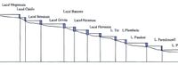 Chain of lakes
 -
 Dynamics of the water areas
 -
 Flooding risk area on the banks of Fundeni Lake


Water as a living space
- Which habitats can be found in and along the water areas of your area?
The strong anthropization of the territory along the Colentina River determined the replacement on large surfaces, of the vegetation as a result of industrialization, cultivation and urbanization. From a biogeographical point of view, the whole unit belongs to the forest-steppe area in the mixture with that of the deciduous forest area. The development of spontaneous vegetation is noticeable, consisting of trees in which it predominates poplar, bushes and herbaceous plants. The grassy layer consists of elements belonging to the steppe meadows.[5] Along the Colentina River you can find habitats specific to aquatic and plain areas. Fauna includes several species of fish, but artificially introduced, such as: dwarf catfish, crucian carp, perch, bream. There are also many species of birds, such as: wild duck, night heron, rodent gull, stork, swan, as well as amphibians and reptiles, such as: the Romanian aquatic turtle which is a protected species, the water snake and the great lake frog.[6]
- How is the water quality in your water areas?
The water quality in the Fundeni Lake is generally good as it does not face serious problems of contamination with pollutants, while according to a study done by Stănescu S.V.[7] the presence of pathogenic germs can be observed, which can indicate that the water was contaminated with faeces. It also states that it is possible to exceed the maximum allowed values for some heavy metals that can be a danger to human health if water is consumed directly from the river or if fish is consumed excessively. Anyhow we have observed that there is an accumulation of plastic debris on the banks of the lake, that can over time drift into the water body, and through a culmination of physical, biological, and photodegradation caused by sunlight exposure, reduce the structural integrity of plastic debris, and classify as microplastics which be a danger to human health if water is consumed directly from the river or if contaminated fish is consumed.
- Which areas are still natural, which are urbanised/artificial?
- Are the rivers permeable for fish or blocked by artificial elements?(approx 200 signs)
The permeability for fish is quite reduced as it is blocked on the eastern side by a barrage which is crossed by Fundeni Road, while on the eastern side it only goes as far as to the barrage on the south-eastern part of the Plumbița Lake. The connection between the two bodies of water of the Fundeni Lake is made through a small channel under the bridge in the south that allows unbounded passage of fish.
- add 1-2 graphical representations to the image gallery, you can add more if you like
-
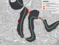 Permeability of the chain of lakes for fish and accumulation of plastic debris on the lake banks
 -
add a caption
-
add a caption

Blue and Green Infrastructure
- What are the major potential elements of a green/blue infrastructure network? Are these likely to change/disappear? Why is that?
- You find my background material on green infrastructure in our reading list
- add 1-2 graphical representations to the image gallery, you can add more if you like
-
 add a caption
 -
 add a caption


Water as a cultural space
Land use and water
- map the land uses along your water areas: settlements, infrastructure, agriculture, resource extraction, natural areas, energy production...
- describe in particular the historical evolution of land use pattern, please make use of historical maps
- description evolution, status quo and driving forces, is the land use likely to change? Why is that? (approx 200 signs)
- add 1-2 graphical representations to the image gallery, you can add more if you like
-
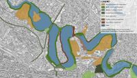
 Activities distribution on the lake banks
 -
add a caption
-
add a caption

Cultural and spatial typologies of water areas
- Which spatial patterns have evolved in relation to your water areas?
- What is the role of water areas within the overall urban morphology? (approx 200 signs)
- add 1-2 graphical representations to the image gallery, you can add more if you like
-
 add a caption
 -
 add a caption


Sacred spaces and heritage
- Which places/elements hold cultural value and to whom?
- You may add a map and some images, please also explain in your caption why these elements are valuable
-
add a caption
-
add a caption
-
add a caption
Visual appearance and landscape narrative
- Which elements are essential for the landscape character?
The main elements that are essential for the landscape is the community formed around these water areas, either it being fisherman or common people performing mundane activities, it’s quite clear that historically there has been a strong connection between the Lake and the People that inhabited it.
- Has the landscape been painted or otherwise depicted, when and whom? Which elements are essential?
While not a specific representation of the Fundeni lake, two centuries ago, Maltese painter Amedeo Preziosi captured through its canvas, two depictions of Coletina River. Both of these pictures the shoreline of the river as a vivid snapshot of unformal settlements and communities performing mundane activities on the shoreline of the swampy lake that has been shaped into the Colentina chain of lakes that we know today.
- Which narratives exist? Who has written about this landscape or depicted it in some way?
There has been depiction that there was a fishing "village". Behind the square, on Lake Colentina, a peninsula glued to the rest of the city by a bridge. It has been written that the fishermen from Ostrov had to reorient themselves. Many sold their properties and moved out of the area. One of the few indications once you step on the peninsula is the street naming that based on different species of fish that could be found in the Fundeni Lake.
-
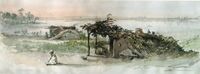 scanned from Adrian-Silvan Ionescu, Preziosi în România, Noi Media Print, 2003, ISBN 973-85881-6-2, 15 June 1869, Colentina River
 -
 scanned from Adrian-Silvan Ionescu, Preziosi în România, Noi Media Print, 2003, ISBN 973-85881-6-2, 15 June 1869, Colentina River
 -
 Article about the the lost chance to have a "fairytale land".


Water and People
Accessibility and usability
- Where are your water areas accessible, and where not? How strong are spatial obstacles preventing access?
- Who is using the spaces and how?
-
 add a caption

Community Mapping
What is to be mapped here?
- Social groups from within the community, for example the youth, kids, students, parents, the retired etc. Typically, these groups have specific needs, which you can also make explicit on the map. These people might not be organized in any way, but they are usually present in the context you are observing
- Local stakeholder groups: these groups are organized in one or the other way. They only exist within the community context you are observing. For example: the local community center, local churches, local interest groups, the landowners, small businesses and retailers
- External stakeholder groups are not necessarily present in the environment you are observing, but they may have strong stakes and interests. These can be local authorities, politicians, associations, care services etc.
- For each group, you may identify their needs, objectives, power and capacities
- You may also identify gaps and power conflicts
- Please try to redepict these elements in an integrated way and in relation to your water landscape. What is the relationship between these groups? Are they close or distanced from each other? Who is more powerful? Which voices are hardly heard? Do they have any shared concerns?
-
add a caption
-
add a caption
-
add a caption
Possible Futures
- You can summarize your findings with a SWOT diagram and a DPSI(R) Model
- Link back to the Sustainable Development Goals: Which goals are at risk?
- What is your worst case scenario for this landscape?
- What is your best case scenario for this landscape?
- Present your scenarios in the form of a collage or sketch
- Add text and visuals
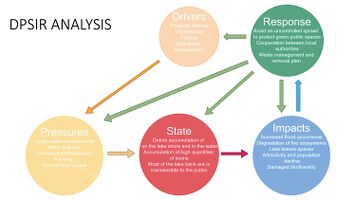
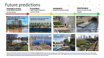
In this section we looked at drivers, pressures, state, impacts and responses, starting with drivers we concluded that the main drivers are Financial interest, urbanization, fishing, and bad waste management and prevention. Which provoked pressure through high-density residential developments that we`re planned in between 2005-2008 but were not realized due to the economic conditions the time, also uncontrolled sprawl in the peninsular area, increased artificialization because of both intensive building and hydrological operations that took place in (20)h) last century, while a continuous problem with fencing of the lake shore and water pollution, especially in shape plastic and litter accumulation on the shores. The problematic state that can be seen in our water areas, is in line with most of the lake chain of the Colentina River which are debris accumulation on the lake shore, increased quantities of toxins in the water and its mostly inaccessibility to the public and to most of the locals. This state had an influence on flood occurrence, with limited severity, lack of leisure spaces along the lake shores or a disjunction between these activities and the landscape, degradation of ecosystems and furthermore a reduced biodiversity, and through a culmination of consequences, a decreased attractivity and population decline. The responses that should be implemented are along the lines of avoiding an uncontrolled sprawl as an effort to protect the green public spaces, improved cooperation between local authorities and an efficient waste management and removal plan, geared for the water areas. So next we`re looking at the future, based on our predictions of current trends, if action would not be taken, it is possible that the water quality could suffer greatly while most of the lakes shore is being fenced as an effort to protect the private land and furthermore new high-density developments could appear like what was planned back in 2008. Not acting against the current problems with littering might further degrade the natural environment. While it is probable that with good, targeted actions we could overcome some of the issues at hand. Like accessibility of the lake shores and creating a higher quality of public spaces that could positively influence this water areas. While some types of litter trapping and measures for flood prevention could improve both the quality of life and the state of the ecosystems involved.
-
 '
' -
 '
' -
 '
'


Collaborative Goal Setting
- Define strategic planning objectives based on the evaluation findings from your analysis
- Ideally, involve the community of your living labs into this process
- Link back to your original targets from section one and the Development Goals
- 150 words text contribution
Based on the lake’s analysis, we have set a few planning objectives that link back to some the UN Sustainable Development Goals:
- increased accessibility and connectivity to the lake with a focus on pedestrians and alternative means of transport such as bikes. Especially, considering that currently 50% of the lake’s adjacent surface is inaccessible for pedestrians due to the built area on the shoreline
- habitat and ecological restoration of the site, given the fact that most of the living species are endangered or disappeared because of the high pollution and that the green infrastructure is damaged and a threat because of the urban fabric densification
- reduced pollution and sustainable approach in development, as the site suffers from a poor household waste management and a chaotic development of the urban fabric that is focused on high density buildings, so it lacks a sustainable approach.
Spatial Strategy and Transect
- translate your strategic goals into a vision
- develop a spatial translation of your vision
- exemplify your vision in the form of a transect with concrete interventions
- add map(s) and visualizations
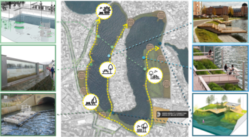
In 10 to 15 years from now, the Lake Fundeni 2 shores should has developed as a neighborhood center, balancing in a cohesive manner all the functional zoning. The region is growing, integrating the natural and built elements and the social aspects of the community enriched on the island and on the neighboring residential areas. The area is accessible due to a democratization of the water shore area. The different sequences along the shores have been connected through a green route made from parks, public gardens, playgrounds, and public spaces, carefully designed for pedestrian needs. This route includes commercial zones sensible places along the route as well, creating a comprehensive sustainable system.
This sequence of different public spaces provides a connected green route through the landscape of Fundeni Lake, assimilating activities that will be geared for all people, including pontoons for sightseeing and fishing, wetlands that can be used as a measure to prevent flooding and as a habitat for fauna, open commercial area for meeting and recreation, alleys across the lakeshore for walks, and playgrounds for children as they are the one that should be educated to cherish and protect these environments in the future.
-
 add caption here
 -
 add caption here
 -
 add caption here


From Theory of Change to Implementation
- For implementing your vision: Which partnerships are needed? Which governance model is required?
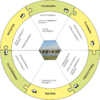
Our vision should be implemented through a holistic approach centered around participatory governance. Without the involvement of the community, it would be quite hard to forge out a sense of responsibility and preservation of this common heritage defined by the Fundeni Lake.
- Who needs to act and how? Draw and explain a change/process model/timeline
The process of implementation should take an open circular approach, the philosophy of co-design, initiative and prototyping should be at the core of the working model. As long-term solutions can be jump-started by building and refining quick working models while generating dialog in the community can provide opportunities for a quick inclusive and iterative processes.
- Which resources are needed? On which assets can you build?
- add 150 words text and visuals
-
 add caption here
 -
 add caption here


References
- give a full list of the references you have used for your case
[1] Gogu, C.R., Gaitanaru, D., Boukhemacha, M. A., Serpescu, I., Litescu, L., Zaharia, V., Moldovan, A., Mihailovici, M. J., 2017, „Urban hydrogeology studies in Bucharest City, Romania”, Procedia Engineering, 209, 135-142. https://www.sciencedirect.com/science/article/pii/S1877705817361428.
[2] Comănescu, L., Nedelea, A., Stănoiu, G., 2017, „ GEOMORPHOSITES AND GEOTOURISM IN BUCHAREST CITY CENTER (ROMANIA)”, QUAESTIONES GEOGRAPHICAE, 36, 3, 52-55. https://www.researchgate.net/publication/320379511_Geomorphosites_and_Geotourism_in_Bucharest_City_Center_Romania.
[3] IDEI URBANE (2010), „EXCLUSIV. „Cu barca prin Colentina”, accessed on 22/03/2121. https://comunadobroesti.wordpress.com/despre/.
[4] SELECT NEWS (2010), „EXCLUSIV. „Satul” Ostrov – cum a ratat Bucureștiul șansa de a avea un ținut de poveste”, accessed on 23/03/2121. https://selectnews.ro/satul-ostrov-cum-ratat-bucurestiul-sansa-de-avea-tinut-de-poveste/.
[5] COCOŞ O., “MANAGEMENTUL APEI ÎN MUNICIPIUL BUCUREŞTI”, Editura Ars Docendi, 2006.
[6] Indepedența Română (2019), „APELE ROMÂNIEI - SALBA D EALCURI DIN JURUL CAPITALEI”, accessed on 31/03/2121. https://www.independentaromana.ro/apele-romaniei-salba-de-lacuri-din-jurul-capitalei/.
[7] Stănescu, S. V., 2011, „Aspecte ale calităţii apei râului colentina pe traseul din municipiul bucureşti (românia)”, Ecoterra, 27, 53-56. http://www.ecoterra-online.ro/files/1321372552.pdf.
Process Reflection
- Reflect in your intercultural and interdisciplinary team on the outcomes of your study
- Which limitations were you facing?
- What have you learnt from each other?
- What did you learn in the Living Labs?
- What would you do differently next time?
- You can also use diagrams/visuals
- 250 words text