Lacul Grivita Living Lab 2022
>>>back to working groups overview
| Area | GRIVIȚA LAKE | |
| Place | Bucharest | |
| Country | Romania | |
| Topics | landscape, water areas, lakes, water dynamics | |
| Author(s) | Cîmpineanu Ioana, Cioacă Gabriel, Costache Elena | |

| ||
Rationale
- Why do you think this case is relevant? What is your hypothesis considering the landscape challenges?
Grivița Lake (75,85ha) is a lake situated in the north-western part of Bucharest (in section 1) and it is included in the chain of lakes that forms Colentina River, between Străulești Lake and Băneasa Lake. This study case is important not only because it’s a recreation area where you can practice fishing and because it is placed in the vicinity of important new neighborhoods like Bucureștii Noi, Dămăroaia and Vatra Nouă, but also because its purpose is flood mitigation and protection. Its floodplain has the potential of becoming a protected natural park. The challenge this lake faces consists in the fact that it is polluted because of uncontrolled discharges of domestic and rain water waste and littering caused by human activities.
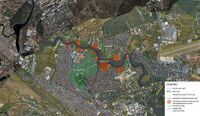
Location and scope
You can edit this map with the map editor
Water as a natural system
Geomorphology, typologies and dynamics of water areas
- Describe the water areas of your area in the context of the wider water system.
Grivița Lake is an antropic lake and it is part of the chain of lakes that form Colentina River (37.4 km on the land of Bucharest), between Străulești Lake upstream and Băneasa Lake downstream.
Colentina River is formed of 15 lakes, from upstream to downstream: Buftea, Mogoșoaia, Chitila, Străulești, Grivița, Băneasa, Herăstrău, Floreasca, Tei, Plumbuita, Colentina, Fundeni, Dobroești, Pantelimon, Cernica.
- How does water appear in the landscape of your living lab? What types of water areas are common?
The waters appearing in our area are rivers and lakes. The rivers (Dâmbovița and its tributary, Colentina) are natural, but they suffered antropic interventions on the chain of lakes that form them. For example, Dâmbovița River was barred to form Morii Lake and Colentina River had interventions for forming the chain consisting of the 15 lakes. Some of the lakes had the purpose of becoming reservoir lakes (ex: Buftea Lake), others of flood mitigation and protection (ex: Grivița Lake).
- Please identify the water bodies' catchment areas, tributaries and floodplains
Grivița Lake is part of the chain of 15 lakes that form Colentina River between Străulești Lake upstream and Băneasa Lake downstream. Colentina River is a tributary to Dâmbovița River. Also, Colentina River has tributaries of its own: Baranga, Crevedia, Valea Saulei. Its catchment areas are in the north-western part of the lake and its floodplains are in the northern and southern parts.
- Which dynamics do these water areas have?
The Bucharest’s waterscape is in constant change, directly caused by urban expansion developing in a disorganized manner, the link between industrialization and the presence of toxic chemicals in water bodies. Grivita Lake being an antropic lake, it underwent human intervention and activity, such as littering. Regarding water’s chemical properties, in analyses of water quality, the maximum permitted values for cadmium, copper, lead, and phosphorus are exceeded, however the pH,nitrites and nitrates and the presence of ammonium and zinc are within the permitted values. Moreover, in the water were found fecal coliform bacteria, such as E.Coli.
- Have there been any flood events in the past?
There have been flood events in the past, especially in the Dămăroaia neighborhood caused by the breaking of the dam placed in the eastern part of the lake.
- add 2-3 graphical representations to the image gallery, you can add more if you like
- try to use drawings that express the system dynamics
-
 Context in the capital
 -
 Context on a smaller scale


Water as a living space
- Which habitats can be found in and along the water areas of your area?
Because of the amount of phosphorus and bacterias in the water exceeding the permitted limits, the lake forms a layer of algae, especially in the spring and summertime.
On the floodplain of the lake are planted forsythia (shrubs), poplars, willows
Considering that the lake is a place where you can practice fishing, the fauna of the lake consists of different species of fish (crucian, carp, bream), but also frogs.
- How is the water quality in your water areas?
The quality of Grivița Lake is affected by the fact that some elements are found in a bigger quantity than normal: cadmium, lead, copper, phosphorus. Also, the water contains bacterias like Escherichia coli.
According to the National Administration of Romanian Waters and Lake, the Administration of Lake, Parks and Recreation and the Order 161/2006 (regarding water management) the pH of the water falls within the allowed norms.
Also, the pollution of the lake is caused by uncontrolled discharges of domestic and rain water waste and by littering caused by human activities.
- Which areas are still natural, which are urbanized/artificial?
In all three neighborhoods that delimit the lake (Vatra Nouă, Dămăroaia, Bucureștii Noi) there is uncontrolled urban development, that has reached the floodplain, fact that does not follow the norms (the urbanism norm that the protection zone of the lake will have 50 m).
There are portions of free land, especially on the northern and south-western floodplains of the lake that have the potential of becoming natural protected parks, which is also sustained by the protected area, a land with value that is situated in its vicinity (Bazilescu Lotting).
-
 Floodplain plants
 -
 Urban development captured from public property


Blue and Green Infrastructure
- What are the major potential elements of a green/blue infrastructure network? Are these likely to change/disappear? Why is that?
The most significant potential element of a green/blue infrastructure is the lakes’ floodplain. This, sustained by the fact that its neighboring land is a protected lotting and has value, gives the opportunity for transforming the floodplain into a natural protected park. These elements are likely to change for the worse if the uncontrolled urban development that is now happening in the area won’t stop.
- You find my background material on green infrastructure in our reading list
- add 1-2 graphical representations to the image gallery, you can add more if you like
-
 Potential and risks map

Water as a cultural space
Land use and water
- map the land uses along your water areas: settlements, infrastructure, agriculture, resource extraction, natural areas, energy production...
The most common activity in the neighborhoods that delimit the lake is living, whether it’s individual or collective. The neighborhoods are properly equipped with schools, cultural points (amphitheater, library, theater), churches, dispensaries and leisure spaces.
- describe in particular the historical evolution of land use pattern, please make use of historical maps
In the XIX century, Bucureștii Noi neighborhood was an estate in the property of Nicolae Bazilescu, a lawyer and university professor. He divided the land into lots and sold a half of it and donated a part to the city hall. After this, the neighborhood started to expand, but it was an area with modest houses. Over the past few years, the neighborhood started to become a lot more popular and gained more residents.
- description evolution, status quo and driving forces, is the land use likely to change? Why is that? (approx 200 signs)
The evolution of the land is typical for a land that is situated at the periphery of a big city. It has been converted into residential areas. The land use is not likely to change, but it is likely to become nonfunctional if the uncontrolled urban development isn’t stopped.
- add 1-2 graphical representations to the image gallery, you can add more if you like
-
 Land uses along your water areas
 -
 Historical Evolution Of Grivita Lake


Cultural and spatial typologies of water areas
- Which spatial patterns have evolved in relation to your water areas?
Due to the new neighborhoods (Bucureștii Noi, Vatra Nouă, Dămăroaia) that are situated in the suburbs, the area has gained a lot of new residents over the last years. The idea is to live in an area that is less polluted and noisy. Also, the lands are cheaper. So, from an undeveloped area, it transformed into a crowded one.
- What is the role of water areas within the overall urban morphology? (approx 200 signs)
Grivița Lake is an element of potential for the sites in its vicinity whose maximum has not been exploited.
The facilities are not located in the immediate vicinity of the lake, a factor that provides easy access from the residential areas and their efficient operation.
The free land represented by the lakes’ floodplain and its surroundings can be transformed into a protected natural park (encouraged by the proximity of the Bazilescu Protected Lotting), thus resulting in a greater number of users who come to spend their free time and potential future inhabitants, who will use the facilities from the neighborhoods, which is economically advantageous.
- add 1-2 graphical representations to the image gallery, you can add more if you like
-
 Cores of residential buildings on the site
 -
 Collective living on the site
 -
 Individual living on the site'


Sacred spaces and heritage
- Which places/elements hold cultural value and to whom?
The places holding cultural value are Bazilescu Lotting, Bazilescu Park and Bazilescu church in Bucureștii Noi neighborhood. They hold cultural value to the city and are considered historical monuments.
- You may add a map and some images, please also explain in your caption why these elements are valuable
These elements are valuable because they are considered historical monuments and have historical meaning for Bucharest.
-
 Historical monuments

Visual appearance and landscape narrative
- Which elements are essential for the landscape character?
The essential elements for the landscape character are the presence of flora, fauna and the community who lives near the lake. All these elements are in a interrelation with the Grivita Lake, they are forming the context which make the lake a living space.
- Has the landscape been painted or otherwise depicted, when and whom? Which elements are essential?
The landscape haven't been painted or depicted yet.
- Which narratives exist? Who has written about this landscape or depicted it in some way?
The Grivita area is mentioned in different sources such as online article of Romanian newspaper like Mediafax.ro, Hotnews.ro and in the town hall website.
-
 Essential Elements for the landscape

Water and People
Accessibility and usability
- Where are your water areas accessible, and where not? How strong are spatial obstacles preventing access?
The water areas are accessible from the unbuilt lands (in the northern and south-western parts of the lake) and from the roads that lead to the lakes’ floodplain in the built communities that are not gated or private.
The spatial obstacles preventing access are strong and consist in the gated/private communities built directly on the floodplain, uncontrolled urban developments that do not respect the urbanism norm that the protection zone of the lake is 50 m.
- Who is using the spaces and how?
The free land is public property, but the communities built directly on the floodplain are private, the land was expropriated and investors developed small communities.
-
 Accessibility and property

Community Mapping
What is to be mapped here?
- Social groups from within the community, for example the youth, kids, students, parents, the retired etc. Typically, these groups have specific needs, which you can also make explicit on the map. These people might not be organized in any way, but they are usually present in the context you are observing
Because of the suburbanization phenomenon that has happened over the past few years, the largest share of the neighborhood’s residents is represented by the working class (adults between 18-65 years). They moved to the suburbs for a less polluted and noisy environment. But, the neighborhoods are formed, of course, of all age categories.
1.Needs of the children (0-18 years)
Safety
Education
Playgrounds
Parks
2. Needs of the adults (18-65 years)
Safety
Jobs
Commercial spaces
Leisure spaces
3. Needs of the older (+65 years)
Safety
Commercial spaces
Leisure spaces
Health equippments
- Local stakeholder groups: these groups are organized in one or the other way. They only exist within the community context you are observing. For example: the local community center, local churches, local interest groups, the landowners, small businesses and retailers
In the neighborhoods delimiting the lake there are a lot of stakeholder groups. There are a lot of churches (orthodox and catholic), social offices, landowners, small companies and public administration.
- External stakeholder groups are not necessarily present in the environment you are observing, but they may have strong stakes and interests. These can be local authorities, politicians, associations, care services etc.
External stakeholder groups are represented by architects, urban planners and real estate investors.
- For each group, you may identify their needs, objectives, power and capacities
The architects and urban planners objectives are to improve the sites’ quality for which they need the support of the community. While their capacities are many, their power is through the community and local authorities.
- You may also identify gaps and power conflicts
- Please try to redepict these elements in an integrated way and in relation to your water landscape. What is the relationship between these groups? Are they close or distanced from each other? Who is more powerful? Which voices are hardly heard? Do they have any shared concerns?
The conflicts arise between the architects, urban planners and community and the private investors. The architects and urban planners are trying to improve the quality of the land and the lake, but the private investors have financial interests, from this resulting uncontrolled urban development.
The conflict prevents the lakes’ floodplain from becoming a natural protected park and contradicts the urbanism norms for the protection zone of the lake of 50m.
-
 Process of the interventions with the help of the community and other urban actors

Possible Futures
- You can summarize your findings with a SWOT diagram and a DPSI(R) Model
-
 SWOT Analysis
 -
 DPSIR Analysis


- Link back to the Sustainable Development Goals: Which goals are at risk?
In the DPSIR analysis we identified the drivers: natural resources, field resources, fishing and urbanization. The main pressures consist in the uncontrolled urban development, pollution, expropriated lands, protection area and floods. The state consists of polluted water and floodplain, affectation of the natural habitat and neglected free lands. These impact the area creating a degraded ecosystem and habitat, chaotic real estate development, absence of leisure spaces, affectation of the protected areas (ex: Bazilescu Lotting) and of the whole area itself.
The main goal that is at risk is the transformation of the floodplain into a natural protected park because of the uncontrolled urban development. This also results in the absence of leisure spaces and biodiversity, so decreased attractiveness of the area.
- What is your worst case scenario for this landscape?
The worst case scenario is that all free lands will be expropriated to real estate investors who only have their financial interests in mind, so the site will suffer. The floodplain will be filled with houses, the norm of the 50m protection area won’t be taken into consideration and the water will become even more polluted due to littering caused by human activities and uncontrolled discharges of domestic and rain water waste.
- What is your best case scenario for this landscape?
The best case scenario is that the lands including the floodplain will be expropriated back to the state and by this the uncontrolled urban development will be stopped, resulting into transforming the floodplain into a protected natural park, creating biodiversity by bringing diverse flora and fauna, creating leisure spaces and repairing the mechanisms of the dams’ gates.
- Present your scenarios in the form of a collage or sketch
- Add text and visuals
-
 Vision
 -
 Vision
 -
 Vision


Collaborative Goal Setting
- Define strategic planning objectives based on the evaluation findings from your analysis
- High attractiveness of the area
- Attractive floodplain
- Biodiversity
- High accessibility to the lake
- Ideally, involve the community of your living labs into this process
- Link back to your original targets from section one and the Development Goals
- 150 words text contribution
Spatial Strategy and Transect
- translate your strategic goals into a vision
In 2034, Grivița Lake is an element of potential for the neighborhoods that delimit it, but also for Bucharest itself. The whole area consisting of the lake and its vicinity gained a higher attractivity due to the transformations from the last twelve years.
The strategic development that has happened for the past years has brought new residents into the neighborhood. Predominant, they are adults that have brought their families into the suburbs for a less polluted and noisy environment. Here, they found a pleasant environment, propitious for raising a family, a place where you can come to, from the crowded city and just disconnect from the urban chaos.
The floodplain is now a protected natural park, a space for leisure where people spend their free time in a relaxed, harmonious environment. They sit on benches and admire the lake, ride their bikes, have picnics or simply walk. There are playgrounds arranged for the kids.
The low pollution is also sustained by the fact that there are recycling systems with sorting containers and water collecting systems.
The biodiversity given by the various flora and fauna on the lake is a clou for the lake and the sites surrounding it.
There is high accessibility to the lake, especially because the land has been expropriated back to the state and there are no more uncontrolled urban developments. The urbanism norm that the protection zone of the lake is 50 m is being taken into account.
Taking all of the above into consideration, the presence of new residents and passengers who come to admire the park and the lake also increases the economy for the local comercial and services activities.
The neighborhoods are a silent oasis at the periphery of a chaotic city.
- develop a spatial translation of your vision
- exemplify your vision in the form of a transect with concrete interventions
- add map(s) and visualizations
-
 Spatial translation
 -
 Transect
 -
 Visuals
 -
 Visuals


From Theory of Change to Implementation
- For implementing your vision: Which partnerships are needed? Which governance model is required?
- Who needs to act and how? Draw and explain a change/process model/timeline
The urban actors involved in this process are: Bucharest City Hall, Section 1 City Hall, Sections’ 1 Public Domain Administration, private investors, sanitation agents and the members of the community.
Staging:
-Program to stop the uncontrolled urban developments on the lakes’ floodplain (2022-2026)
-Program to create a higher lake accessibility (2022-2026)
-Program to transform the floodplain into a natural protected park (2026-2030)
-Program to bring biodiversity on the floodplain (2026-2030)
-Program to rise the economy of the limiting neighborhoods (2030-2034)
-Program to transform the place into an eco-friendly one with recycling and water collecting systems (2030-2034)
- Which resources are needed? On which assets can you build?
- add 150 words text and visuals
-
 Process of the interventions with the help of the community and other urban actors

References
- give a full list of the references you have used for your case
- Wave courses
- http://urbanism.pmb.ro/index.aspx
- http://www.alpab.ro/Lacuri_c.htm
- https://www.google.com/maps/place/Lacul+Grivi%C8%9Ba/
- https://lege5.ro/Gratuit/ge3demru/legea-apelor-nr-107-1996
- https://fostulbucuresti.github.io/#15.66/44.49656/26.05329/0/!p1!p2!a4!a7
Process Reflection
- Reflect in your intercultural and interdisciplinary team on the outcomes of your study
We tried to capture Grivița Lakes’ and its surroundings’ image in the best way we can with the given data and resources we have at the moment. The main goal was to capture the state of the site and brainstorm for possible goals regarding it.
- Which limitations were you facing?
The limitations we faced were the different information we gathered all from reliable sources (ex: the surface of the lake) and other examples.
- What have you learnt from each other?
We learnt to work as a team, to brainstorm and to find ways to transmit information in the clearest way possible.
- What did you learn in the Living Labs?
We learned a lot about water and landscapes, information that will not only help us in our career as urban planners, but for our general knowledge. We also learned a lot about how to transmit information to others with an adequate language, as we are speaking to people who don’t have the same preparation as we do. We found the DPSIR analysis very useful, analysis that we did not use until this lab.
- What would you do differently next time?
Next time we would rely more on what the community has to say and we would ask people from larger age categories what their opinions are on the area they live in because they know the most about it.
- You can also use diagrams/visuals
- 250 words text