Lacul Plumbuita WAVE Living Lab 2021
>>>back to working groups overview
| Area | Plumbuita Lake | |
| Place | Bucharest | |
| Country | Romania | |
| Topics | please enter the main topics of your living lab | |
| Author(s) | Zoheir-Alexandru Chakhachiro, Ana-Maria Durlă, Denisa-Sorina Lungu, Antonia Panaitescu, Sabrina Andreea Spînulescu, Zlotea Alexandra | |

| ||
Rationale
- Why do you think this case is relevant? What is your hypothesis considering the landscape challenges?
- Format: 3-4 sentences
Location and scope
You can edit this map with the map editor
Water as a natural system
Geomorphology, typologies and dynamics of water areas
- Describe the water areas of your area in the contxt of the wider water system
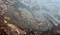
On the Colentina valley, from Ghimpați to the confluence with Dâmbovița, 18 lakes have been arranged, with a total area of 1934 ha. The Plumbuita Lake is part of the chain of lakes of Bucharest, part of the Lake of Colentina. They form a chain of lakes beginning at an altitude of 131 m (L. Ghimpați) and ends at 54,1 m (L. Ghimpați, Cernica). From upstream to downstream: The lake Ghimpați (52 ha), Vizurești (103 ha), Ciocănești (98 ha), Buftea (307 ha), Buciumeni (60 ha), Mogoșoaia (56 ha), Chitila (39 ha), Străulești (33 ha), Grivița (50 ha), Băneasa (40 ha), Herăstrău (77 ha), Tei (80 ha), Plumbuita (55 ha), Fundeni (123 ha), Pantelimon I (53 ha), Pantelimon II (337 ha) and Lake Cernica (301 ha) - (Figure 1) The lake system of the Colentina River, designed about 80 years ago, is a public good, a cultural monument and a fundamental element of Bucharest, connecting the city to its metropolitan area. The project was designed and implemented with the aim of contributing to the health and well-being of all citizens. Lakes occupy 3.25% of the city's area and have great potential in terms of providing recreational opportunities, climate balancing, small-scale economic opportunities and general improvement in environmental quality.
- How does water appear in the landscape of your living lab? What types of water areas are common?
The Plumbuita Lake is an artificial lake, part of the lake of Colentina and integrates recreational areas, in this case, the most important being The Plumbuita Park, located on the shore of the lake. The island of Plumbuita Lake has an area of 1,94 ha. On the right bank of Plumbuita Lake there is the Plumbuita Monastery, near which the Plumbuita Park was arranged.
Regarding the connection with the built-up heritage around it, Plumbuita Lake is located in the Plumbuita neighborhood, in the second district of Bucharest. The Plumbuita neighborhood is a mainly bedroom, a residential area.
Bucharest is situated on the banks of the Dâmbovița river, which flows into Argeș, an affluent of the Danube Rvier. Several lakes extend along the Colentina River, in the city perimeter, such as the Herăstrău Lake, the Floreasca Lake, the Tei Lake or the Colentina Lake. In the center of the city there is a lake in Cișmigiu Park. This lake, the former bard in the old medieval town, is surrounded by the Cișmigiu Garden, which opened in 1847 according to the plans of German architect Carl F. W. Meyer. Therefore, Bucharest possesses a valuable hydrographic area, the types of water being:
- rivers and
- lakes (artificial or natural).
In general, hydrography features close to or are part of a leisure area (parks, green areas near a residential area, gardens or public pedestrian areas).
- Please identify the water bodies' catchment areas, tributaries and floodplains
The anthropic lake Plumbuita (55 ha) is located on the Colentina river, thus it is part of the of the Arges river’s water bodies and is a left tributary of the Dambovita river, and Dambovita in turn is a tributary of the Arges. Lake Plumbuita has Lake Tei upstream and Lake Fundeni downstream. The lake system of the Colentina River, designed about 80 years ago, is a public good, a cultural monument and a fundamental element of Bucharest, connecting the city to its metropolitan area. The project was designed and implemented with the aim of contributing to the health and well-being of all citizens. Lakes occupy 3.25% of the city's area and have great potential in terms of providing recreational opportunities, climate balancing, small-scale economic opportunities and general improvement in environmental quality.
- Which dynamics do these water areas have?
Water dynamics are a consequence of the fact that “rivers are highly complex systems within which interconnected processes occur simultaneously: physical, chemical and biological processes exert reciprocal influences” (Prominski, Stokman et al, 2017). Types of dynamics which occur in water landscapes are: level fluctuation (vertical dynamics), horizontal spread (horizontal dynamics), changing course, erosion, sedimentation. In the case of Plumbuita Lake, water dynamics refer mainly to three kinds of phenomena: erosion, rise of neighbouring water levels and change in the chemical and biological processes.
During a geomorphological study of the 2nd District’s area, there have been identified 2 types of erosion typical to Colentina river: torrential erosion and wind erosion, which occurs during summer drought. Moreover, due to the proximity of a smaller river, Șaulei (Valea Șaulei), Plumbuita Lake is prone to rise of vertical water levels and approximately 126 streets in the area are exposed (PUZ Sector 2, 2019).
Regarding water’s chemical properties, water contamination is well-spread across Bucharest’s waterscape, generally caused by chaotic urban development, badly managed construction sites, downloading of toxic chemicals and open brownfields. In a study on heavy metal concentrations in the water of Plumbuita Lake, the outcomes revealed that: “Although the water was not found to be critically polluted regarding heavy metal load, the situation still remains a matter of concern” (Ionescu, Radu, 2017).
- Have there been any flood events in the past?
Plumbuita Lake, being an anthropic lake, does not have the best solution against floods. Therefore, it had a rising water level approximately every year. The most devastating flood took place in late-2005 where the houses of the people on the shore suffered, the distance to the overflow being 20 centimeters (it appears in MediaFox).
-
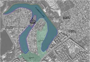
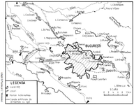 Fig.1 The hydrographic network in Bucharest
 -
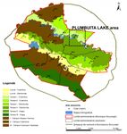 Fig.3 Bucharest Floodplains and Plumbuita Lake
 -
 flood zone


s
Water as a living space
- Which habitats can be found in and along the water areas of your area?
Existing species of fish are habitual for this geographical position, such as Wels and African catfish, carp, crucian, redfish. At the same time, small species of turtles, frogs, and worms can be found in the water. When the water was cleaner, ducks, swans, and seagulls surrounded areas, in addition to everyday pigeons.
- How is the water quality in your water areas?
The water quality in this area is deteriorated by its inhabitants and the park next to it. The soil and water on the beach are heavily polluted. Not only because of household waste but also because of the poor care of the lake in recent years.
- Which areas are still natural, which are urbanised/artificial?
Given that this lake is anthropogenic, most of the vegetation was added, principally that of Plumbuita I and II parks. Also, the trees and the lawn that surrounds it. Although the urban landscape has a lot of potentials, its plan has been abandoned since the early '90s.
- Are the rivers permeable for fish or blocked by artificial elements?
-
Fig 1 Polluted waterfront soil
-
add a caption
-
add a caption
Blue and Green Infrastructure
- What are the major potential elements of a green/blue infrastructure network? Are these likely to change/disappear? Why is that?
- You find my background material on green infrastructure in our reading list
- add 1-2 graphical representations to the image gallery, you can add more if you like
The island (with interesting vegetation) is located to the west of the monastery and is easily accessible on the walkway from which it opens and a path (blocked) to the monastic settlement. It was also arranged years ago (lakebanks) but complicated local interests left it to the living in the wild (also present in many parts of the parks in the northeast of Bucharest). With the exception of the northern and northeastern parts of the lake (to which the lyses are grouped), the other banks are furnished with pleasant alleys, bordered by extensive vegetation.
POTENTIAL BLUE INFRASTRUCTURE: Plumbuita Lake - part of a bigger lake system (Colentina River)
ACCESIBLE LAKE SHORE (4.20 km)
VALUABLE LANDSCAPE (lake landscape) AND BUILT HERITAGE (Plumbuita Monastery)
RISKS
UNCONTROLLED URBAN DEVELOPMENT: privatization of the shore and poor waste management
INDUSTRIAL AREA: possibility of expansion to the lake shore
CLIMATE CHANGE: possible expansion of the floodplain and enhancement of the soil erosion
FRAGMENTATION OF URBAN TISSUE: inaccesibility of the lake area due to the vicinity of two major mobility arteries (A3 highway and E85)
-
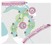 potentials and risks map
 -
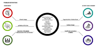 problem definitions

.png)
Water as a cultural space
Land use and water
- map the land uses along your water areas: settlements, infrastructure, agriculture, resource extraction, natural areas, energy production...
- describe in particular the historical evolution of land use pattern, please make use of historical maps
- description evolution, status quo and driving forces, is the land use likely to change? Why is that? (approx 200 signs)
- add 1-2 graphical representations to the image gallery, you can add more if you like
-
add a caption
-
add a caption
-
add a caption
Cultural and spatial typologies of water areas
- Which spatial patterns have evolved in relation to your water areas? What is the role of water areas within the overall urban morphology? (approx 200 signs)
Plumbuita Monastery (which is located at the northern end of the peninsula departing from tram line 21) is well protected from fences and from it cannot be reached at the shores of the lake. Located in a strategic position, at the exit of Bucharest, on a small hill on the banks of the Colentina River, the monastery plays an important role in the defense of the city. In 1632, a high-stakes battle was fought near the monastery, between the Romanian army, led by Matei Basarab, and the Turkish army, led by Radu Iliaş. The name Plumbuita was given to him by the locals, due to the fact that the church was long covered with lead sheet. There are also legends around it, a museum comprising: religious art objects, 130 busts of Romanian rulers (carved in stone by the abbot Simeon Tatu), as well as original murals. The monastery library, known as an old book museum, contains valuable titles, some 500 years old. Within the monastery, the workshops of the Painting, Restoration and Heritage Section of the Faculty of Theology in Bucharest operate. Until recently, the monastery had sculpture workshops, mechanical and manual carpentry, stone-making and metal cult processing workshops, including a bell casting section. (The largest bell cast at Plumbuita Monastery is 1200 kg and is in operation at Radu Voda Monastery in Bucharest). Currently, the monastery is undergoing extensive renovation. The museum in the House of Lordist is closed for restoration work. The workshops were temporarily moved to the commune of Popești-Leordeni. The current population (2007) of the monastery is composed of ten monks, the abbot of the monastery being Father Archimandrit Visarion Marinescu. The island (with interesting vegetation) located on the west of the monastery is easily accessible on the walkway from which it opens and a way to access (locked) to the monastic settlement. It was also arranged years ago (lakebanks) but complicated local interests left it to the living in the wild (also present in many parts of the parks in the northeast of Bucharest).
- add 1-2 graphical representations to the image gallery, you can add more if you like
-
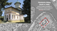
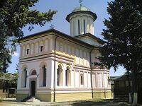 Plumbuita Monastery source https://ro.wikipedia.org/wiki/M%C4%83n%C4%83stirea_Plumbuita
 -
 fountain near Plumbuita Island
 -
 island inside Lake Plumbuita


Sacred spaces and heritage
- Which places/elements hold cultural value and to whom?
- You may add a map and some images, please also explain in your caption why these elements are valuable
Plumbuita Monastery Plumbuita Monastery is an Orthodox monastery of monks, with the birth of St. John the Baptist, located in the Colentina district of Bucharest, on a small hill on the right bank of the Colentina River. The name Plumbuita was given to him by the locals, due to the fact that the church was long covered with lead sheet. There are also legends around this name. It is said that the name Plumbuita comes from the fact that Matthew Basarab, needing cannonballs during the fight, gave to melted the lead roof of the monastery to manufacture them. Another legend says that Matthew Basarab's battle with Radu Iliaş, which took place under the walls of the monastery, was so fierce that the crowd of cannonballs falling on the roof of the church, melting, gave the roof a lead sheen. Located in a strategic position, at the exit of Bucharest, on a small hill on the banks of the Colentina River, the monastery plays an important role in the defense of the city. In 1632, a high-stakes battle was fought near the monastery, between the Romanian army, led by Matei Basarab, and the Turkish army, led by Radu Iliaş. The latter had been sent by the sultan to remove Matthew Basarab from his seat, and installed in his place a ruler appointed by the Ottoman Gate. The battle is won by Matei Basarab, who thus remains on the throne of Wallachia.
-
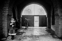 monastery gate
 -
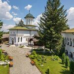 Plumbuita Monastery, source- https://arhiepiscopiabucurestilor.ro/
 -
 Location of the monastery


.png)
Visual appearance and landscape narrative
- Which elements are essential for the landscape character?
- Has the landscape been painted or otherwise depicted, when and whom? Which elements are essential?
- Which narratives exist? Who has written about this landscape or depicted it in some way?
- You can add text and images
-
add a caption
-
add a caption
-
add a caption
Water and People
Accessibility and usability
- Where are your water areas accessible, and where not? How strong are spatial obstacles preventing access?
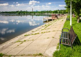
The water area is quite accessible to the public. Access to the waterfront is from both the Plumbuita Park area and the interior of private land that opens to the waterfront and on which there are private properties. The area with the greatest accessibility to the lake is the one inside the park where there is a pedestrian path along the watercourse.
- Who is using the spaces and how?
The space is used by both private landowners, local authorities and people who come for a walk on the lake side in order to relax outdoors.
-
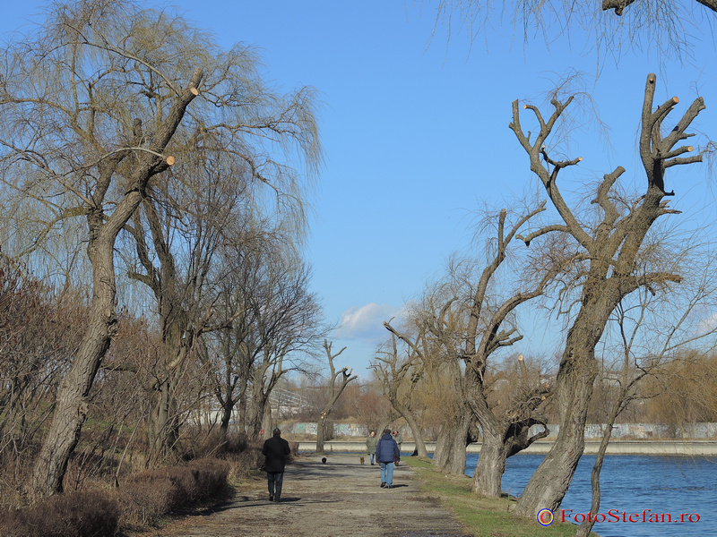
 Plumbuita waterfront (source of image: https://bucurestiulmeudrag.ro/fotografii/5841ed77-6e94-495a-87e7-ddb0592b13d5)
 -
 Activities on the lakeside (source of image: http://www.fotostefan.ro/wp-content/uploads/2015/01/parcul-plumbuita-bucuresti-11.jpg)


Community Mapping
What is to be mapped here?
- Social groups from within the community, for example the youth, kids, students, parents, the retired etc. Typically, these groups have specific needs, which you can also make explicit on the map. These people might not be organized in any way, but they are usually present in the context you are observing
- Local stakeholder groups: these groups are organized in one or the other way. They only exist within the community context you are observing. For example: the local community center, local churches, local interest groups, the landowners, small businesses and retailers
- External stakeholder groups are not necessarily present in the environment you are observing, but they may have strong stakes and interests. These can be local authorities, politicians, associations, care services etc.
- For each group, you may identify their needs, objectives, power and capacities
- You may also identify gaps and power conflicts
- Please try to redepict these elements in an integrated way and in relation to your water landscape. What is the relationship between these groups? Are they close or distanced from each other? Who is more powerful? Which voices are hardly heard? Do they have any shared concerns?
-
 relations between social, external and local stakeholders
 -
 ranking of the main actors involved in the development of the area around Lake Plumbuita
 -
add a caption


Possible Futures
- You can summarize your findings with a SWOT diagram and a DPSI(R) Model
- Link back to the Sustainable Development Goals: Which goals are at risk?
- What is your worst case scenario for this landscape?
- What is your best case scenario for this landscape?
- Present your scenarios in the form of a collage or sketch
- Add text and visuals
-
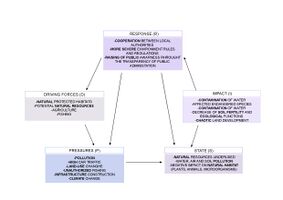 DPSIR model
 -
 narrative scenario
 -
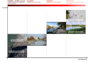 future projections


Collaborative Goal Setting
- Define strategic planning objectives based on the evaluation findings from your analysis
- Ideally, involve the community of your living labs into this process
- Link back to your original targets from section one and the Development Goals
- 150 words text contribution
Our main objectives are: Increase connectivity with the central area and local water systems.
Increasing the attractiveness of the lake for all kinds of users, leading in the development of the area with the increased interest.
The sustainable development of the Plumbuita natural area and the anthropic landscape increasing its resiliency. We’re planning to develop the are by REDUCING THE IMPACT OF NEIGHBOURING INDUSTRIAL ACTIVITY, Preserving and encouraging the biodiversity of the area and increasing the accesiibility of the lake shore.
We also take in consideration the sustainable goals meaning by creating the good health and well being of the community will increase giving them an opportunity to give a sustainable life and also by making those changes in social we.re also revitalising the life on land. The increase in the sustainable goals will lead the government working together with the local actors for the better.
Spatial Strategy and Transect
Following diagnosis and analyses related to the characteristics of the lake Plumbuita area, located in the Northern part of the city of Bucharest, we have concluded that the area isn’t exploited and requires a number of changes, all done in order to revitalize the ecosystem in a state of degradation.
Our vision involves transforming the lake bank and the areas in the vicinity of lake Plumbuita into a quality public space, in order to create a public identity space, which serves as a center of interest both for the inhabitants of Bucharest and for those who transit the area, but also to promote the Plumbuita Monastery, which represents a religious edifice with a high tourist potential. Vision
The proposal aims to increase the interest of the inhabitants for Lake Plumbuita, an objective that is achieved through several measures of economic, social bill, intervention on the endowments and quality of public space.
The central subject of the vision is the sanitization of the water banks of Lake Plumbuita and the reorganization of public spaces according to the principles of design including to meet the requirements of a category of forgeters as large and implicit to encourage the conduct of activities outside the house (recreational and leisure activities, socialization). In this way, the urban space in the vicinity of the lake that includes the two parks becomes a support of the interrelationship, a clean and friendly area, an extension of the private space due to the quality and conditions of maximum safety in which it can be used. Our vision focuses on the introduction of the necessary facilities for carrying out recreational activities (amenjation with urban furniture, implementation of a bike route, as well as the introduction of a rental center for bicycles and scooters, the addition of pontoons on the lake, but also its exploitation by introducing hydrobikes, kayaks and boats, for water rides.
-
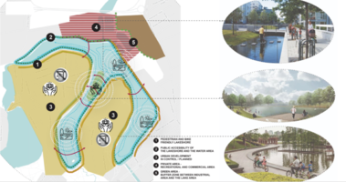 vision
 -
 objectives
 -
 transects
 -
add caption here
.png)
.jpg)
.png)
From Theory of Change to Implementation
- For implementing your vision: Which partnerships are needed? Which governance model is required?
- Who needs to act and how? Draw and explain a change/process model/timeline
- Which resources are needed? On which assets can you build?
- add 150 words text and visuals
-
 add caption here
 -
 add caption here


References
- give a full list of the references you have used for your case
Process Reflection
- Reflect in your intercultural and interdisciplinary team on the outcomes of your study
- Which limitations were you facing?
- What have you learnt from each other?
- What did you learn in the Living Labs?
- What would you do differently next time?
- You can also use diagrams/visuals
- 250 words text