Why do you think this case is relevant? What is your hypothesis considering the landscape challenges?
This case is relevant because it belongs in an area that has a lot of history and potential for its natural characteristics.
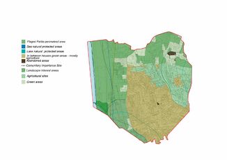
There are lakes, beaches and there are also panoramic walks and remarkable areas that belong to the Flegrei Fields Regional Park.
Both the archaeological sites and the natural protected areas are points of interest that need to be promoted through the landscape projects to not destroy their internal eco-systems and to acknowledge their real importance.
Location and scope
Loading map...
Water as a natural system
Geomorphology, typologies and dynamics of water areas
Describe the water areas of your area in the contxt of the wider water system
The water areas in this area are included into a more wide systems of volcanic lakes that characterizes the Flegrei Fields park. Also, there is a little stretch of coast, identified as Spiaggia Romana.
There are no rivers, indeed they're more like small canals that go into the cultivated areas.
How does water appear in the landscape of your living lab? What types of water areas are common?
In the landscape of the area, water appears as sea and volcanic lakes. It's really common to have beaches and caves, some dunes before you arrive to the beach and cliffs in certain points of the coast line. Also there are cultivated fields served by canals that drain the water from the lakes.
Please identify the water bodies' catchment areas, tributaries and floodplains
Which dynamics do these water areas have?
Have there been any flood events in the past?
There are no flood events recorded in recents years for this specific area, but there have been some flood episodes in the area of the fusaro lake that overlooks via giulio cesare. Mainly of the problems are due to the lack of maintenance of the road surface and drainage for rainwater which does not allow to open waterways towards the mouth and the lake
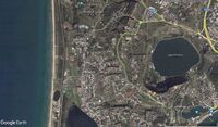
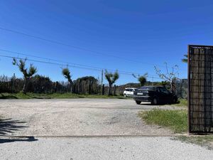
view of the Fusaro lake from the parkwater system in the area - lakes and canals
Water as a living space
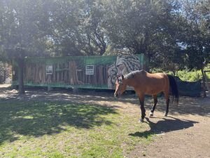
Which habitats can be found in and along the water areas of your area? Along the sea in the area there are agricolture fields, fruit trees and some natural spaces that have no function. The quarantena park near the lake Fusaro and the dunes near the beach side. The area is mostly residential, so also we have a system of single houses with gardens. There aren't a lot of animal species, except for the breeding ones, fishes and some animals that are in the quarantena park for the visitors to see like farm animals, horses and dogs.
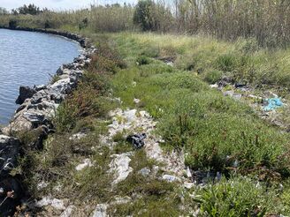
How is the water quality in your water areas? It's largely polluted, for the industrial discharges. Also the lake side is full of garbage, mostly plastic that goes in the water.
Which areas are still natural, which are urbanized/artificial? Mostly, the areas on the direction of the beach are natural because they are protected sites. We have a density of construction going on the direction of the Averno lake, but they are surrounded by green spaces (often with no function or private gardens) and by agricolture spaces, that are the main characteristic of the area. (see the focus map for a clear representation of the different green spaces use).map of the use of the natural areas along the buildings in the area. this is the condition near the lake Fusaro, in the parking lot of the Quarantena Park.
Blue and Green Infrastructure
What are the major potential elements of a green/blue infrastructure network? Are these likely to change/disappear? Why is that?
The main elements of the blue infrastructure are the Fusaro lake, which is located in the lower part of our area, and the coast with the Roman beach, which is located at the slopes of the promontory of Cuma. The Fusaro lake and the sea are connected by the mounth of the lake, which divides the Quarantine Park and the agricultural area.
The main elements of the green infrastructure are the Quarantine park, which covers the total length of the left side of Fusaro lake. The tracks of the Curcumflegrea divide the green area in two part, on the left the abandoned part and on the right the agricultural area. North-west of our area is the promontory of Cuma, the regional forest and the archaeological site of Cuma. Throughout the area there is a strong presence of agricoltural areas, in which there are also many greenhouses.
Main spots of interest for the green infrastructureThe mounth of the lake on the left side, on the right the quarantena park.
Water as a cultural space
Land use and water
map the land uses along your water areas: settlements, infrastructure, agriculture, resource extraction, natural areas, energy production...
describe in particular the historical evolution of land use pattern, please make use of historical maps
description evolution, status quo and driving forces, is the land use likely to change? Why is that? (approx 200 signs)
add 1-2 graphical representations to the image gallery, you can add more if you like
An important characteristic of this land are definally the bathing establishment along the coast cross the quarantena park, in the nothen part it is not quite known. The area is also
characteristic by the strong presence of housing, there are also some schools and many fields, but it is not an area that has been lived bu the inhabitans.
About the historical evolution, there are not been many changes in the last 10 years because the majority of the area has been buit in the early 80s, and there should not be more construction in this area because it can roun its characteristic of being an agricolural town. Many people who live in Bacoli had bought a piece of land in this area even tho they live somewhere else around the town.
Historical evolution of the study area from 2004 to 2021. (2004)
2009
2014
2017
2021
Cultural and spatial typologies of water areas
Which spatial patterns have evolved in relation to your water areas?
What is the role of water areas within the overall urban morphology? (approx 200 signs)
add 1-2 graphical representations to the image gallery, you can add more if you like
In relation with this water area there's a long beach, but suddently it is not very visited. The position of the area is strategic because there's a connection between the sea and Fusaro Lake. Landscapedly they converge with water and vegetation. Suddently the beach is not very visited because of the purifier, it could affect the usability of the place even though this area has a great resource for the inhabitants and visitors.
Sacred spaces and heritage
Which places/elements hold cultural value and to whom?
There are several places with this characteristic within the area, but currenty they are not valued and are in state of neglect.
You may add a map and some images, please also explain in your caption why these elements are valuable
Which elements are essential for the landscape character?
Has the landscape been painted or otherwise depicted, when and whom? Which elements are essential?
Which narratives exist? Who has written about this landscape or depicted it in some way?
You can add text and images
The area currently open to visitors is made up of the acropolis, which encloses the Sibyl's cave on the slopes of the hill, then climbing the fortress the Byzantine Tower with the Belvedere, the Lower Terrace, traditionally called the Temple of Apollo, and the Upper Terrace on the top. of Monte di Cuma, called the Temple of Jupiter. The area of the lower city is currently affected by enhancement works and can only be visited on an extraordinary basis on the occasion of cultural events or demonstrations. The monuments of the lower city are the Forum, the Baths of the Forum, the Roman Crypta, the inhabited area, the Porta Mediana, the Monumental Necropolis.
The Sibyl's Cave is perhaps the most famous monument in the Archaeological Park of Cuma. Archaeological research interprets the monument as a military tunnel dug into the tuff to protect the south-western ridge of the acropolis in the Samnite period, between the end of the 4th and the beginning of the 3rd century. B.C.The tunnel has transversal arms in which some cisterns are obtained, which collected rainwater through a canalization system. In the early Christian period the so-called terminal chamber was reused as a place of worship and the cisterns as a burial place. The definition of Antro della Sibilla is due to Maiuri who in 1932 excavated the monument in the name of the frantic search for the places described by Virgil which lasted for many centuries. The gallery offers the correspondence of some elements with the verses that allude to a mysterious and dark place with "a hundred doors" from which the wind swirled the leaves on which the Sibyl wrote the responses. It is in fact equipped with numerous side openings from which the light enters, which the archaeologist wanted to associate with the "hundred mouths". In addition, the terminal room has three small rooms that lend themselves well to the interpretation of oracular rooms.
Sibyl's Cave in the Cuma's archeological site.Cuma's Archeological Site
Water and People
Accessibility and usability
Where are your water areas accessible, and where not? How strong are spatial obstacles preventing access? The water areas aren't very accessible. You can go to the beach, but there are only a few places where you can park your car and then you have to walk trough the dunes to get close to the sea. In our area the lake is accessible only through the park.
Who is using the spaces and how? The spaces are used by the community that goes on the beach or stays in the park near the lake, doing pic-nic's or playing. There are also people with boats that go on the lake or families that take their children to see the animals that are in the little park farm. one of the beach access. the farm inside the quarantena park.
Community Mapping
What is to be mapped here?
Social groups from within the community, for example the youth, kids, students, parents, the retired etc. Typically, these groups have specific needs, which you can also make explicit on the map. These people might not be organized in any way, but they are usually present in the context you are observing
Local stakeholder groups: these groups are organized in one or the other way. They only exist within the community context you are observing. For example: the local community center, local churches, local interest groups, the landowners, small businesses and retailers
External stakeholder groups are not necessarily present in the environment you are observing, but they may have strong stakes and interests. These can be local authorities, politicians, associations, care services etc.
For each group, you may identify their needs, objectives, power and capacities
You may also identify gaps and power conflicts
Please try to redepict these elements in an integrated way and in relation to your water landscape. What is the relationship between these groups? Are they close or distanced from each other? Who is more powerful? Which voices are hardly heard? Do they have any shared concerns?
In this area there are many residencial parks, so is lived by many families with kids and teens. Outside the residencial parks there are not many places where kinds and teens can meet up, many times they are forced to go somewhere else far from Cuma. Even tho there is an abandoned soccer field and a skating ring that has been a landmark in this part of town. These fields can be an opportunity for the. In Cuma there are no community centers, churces or any tipe of business. Even tho this area is not well illumitadet during the night , there is not any criminality. The main opportunity in this area is for sure make some plases where people can hang out and meet up without moving bay car. There are not very important stakeholders or services.
Possible Futures
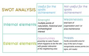
You can summarize your findings with a SWOT diagram and a DPSI(R) Model
What is your worst case scenario for this landscape? The worst scenario for this area is that neglect and degradation compromise not only human activities and possible trade, but also and above all the relationship between the green and blue areas that are very present. At this time the sea on this side of the coast is already very compromised by the nearby purifier, risking to pollute the nearby Fusaro lake.
What is your best case scenario for this landscape? The best possible scenario is that you finally realize the infinite possibilities of this area rich in natural parks and the preponderant presence of water. The consequent enhancement of the arboreal heritage and of the nearby archaeological sites, thus bringing tourists not only to the Miseno coast, which is saturated every summer, but also distributing the crowds of people in this coastline. This type of approach would also benefit in economic terms, producing livelihood also for the maintenance of the enhancement of the assets.
Present your scenarios in the form of a collage or sketcSWOT Analysis
Collaborative Goal Setting
Define strategic planning objectives based on the evaluation findings from your analysis
Ideally, involve the community of your living labs into this process
Link back to your original targets from section one and the Development Goals
150 words text contribution
Spatial Strategy and Transect
translate your strategic goals into a vision
develop a spatial translation of your vision
exemplify your vision in the form of a transect with concrete interventions


 Historical evolution of the study area from 2004 to 2021. (2004)
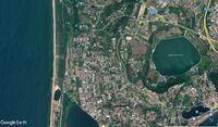 2009
2009 2014
2014 2017
2017 2021
2021


 add caption here
 add caption here
