Transect
>>>back to methods overview
'The Transect approach' - About
Historically, analyses along transects were applied in ecology, history and other disciplines related to urban and landscape planning. Therefore, it was only logical to adopt the method to landscape design, too.
"A transect is a cut or path through part of the environment showing a range of different habitats. Biologists and ecologists use transects to study the many symbiotic elements that contribute to habitats where certain plants and animals thrive." Source: CATS (Center of Applied Transect Studies), https://transect.org
"A transect, in its origins (Von Humboldt 1790), is a geographical cross-section of a region used to reveal a sequence of environments. Originally, it was used to analyze natural ecologies, showing varying characteristics through different zones such as shores, wetlands, plains, and uplands. For human environments, such a cross-section can be used to identify a set of habitats that vary by their level and intensity of urban character, a continuum that ranges from rural to urban. In Transect planning, this range of environments is the basis for organizing the components of urbanization: building, lot, land use, street, and all of the other physical elements of the human habitat." Source: Andrés Duany et al., SmartCode & Manual, Miami: New Urban Publications, Inc., 2005
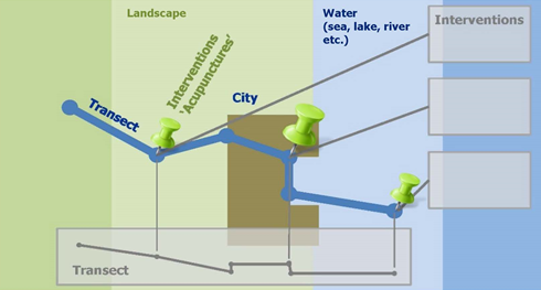
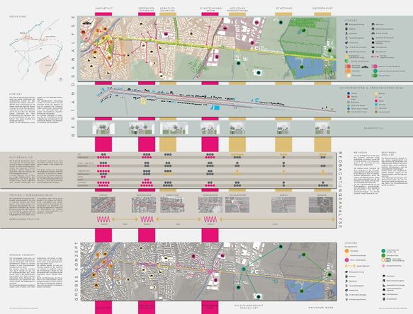
Based on these definitions, the Transect method can be applied in the Living Lab both as a participatory analysis and/or mapping method (e.g. in the form of Transect walks) and as a co-creative design method. Focusing on a line or a path helps to capture the high areal and spatial complexity of landscape or urban contexts in a simple linear form.
What are the goals of this method?
Why transects are a relevant method for participatory design processes?
Every movement (such as walking) is linear. Therefore, the linear observation of the context corresponds ideally to human perception. For this reason, the exploration and design of complex spatial problems along a transect is very well suitable...
- to structure complexity,
- to explain multi-functionality,
- to clarify interdependences and interactions,
- to create spatial systems and social patterns,
- to show insights instead of top views...
...by linear walking, thinking and composing.
What are typical questions this method is able to answer? Which types of knowledge does it generate?
These questions are answered very accurately, for example, in an article by Lisa Diedrich. According to it, transect methods...
- ..."employ the transareal and trans-scalar understanding of Alexander von Humboldt’s scientific model, framed through the landscape architecture lens in a problem-oriented research approach that seeks to map and narrate the relational, the dynamic, and the atmospheric qualities of sites.
- Additionally, the transareal transect method enables designers to focus and reflect on site qualities as a mobile form of on-site exploration, complementary to the in-studio study of documented site conditions such as statistics, cadaster and topographic maps, Google searches, and other pragmatic diagramming techniques.”
- Transects represent "a form of landscape research that constitutes a journey from on-site to non-site, from physical to mental site, from thought to conversation, as we move back and forth. This is an inclusive journey that invites engagement with landscape design as a moment within ongoing and open works.” Source: Lisa Diedrich, Gini Lee, Ellen Braae (2014): The Transect as a Method for Mapping and Narrating Water Landscapes: Humboldt’s Open Works and Transareal Travelling. Available under: https://www.nanocrit.com/issues/issue6/transect-method-mapping-narrating-water-landscapes-humboldts-open-works-transareal-travelling
In which situations can this method be applied?
The Transect method is suitable for both urban and rural contexts, and especially for water landscapes along rivers or coasts. It is appropriate for scientific landscape analysis and design development, combined with other methods such as mapping, behaviour mapping or interviews respectively story-telling. It is an easy method for practical participatory approaches: Walking along the transect with stakeholders and citizens to discuss issues can generate cocreative knowledge and help to discover local problems and potentials together.
How does this method work in practice?
How the transect can be defined? What criteria are used to determine it?
A main principle can be: Along the water and/or across the water. Further criteria are:
- Along the water (river): Following a route or path where a certain perception is possible (land – sea relation, spatial dimensions, vistas etc.)
- Across the water: Representing a gradient (from mountain to sea/river, from rural to urban, from city edge to harbour etc.)
- Crossing representative and important landscape types, types of open spaces, social hotspots, heritage places etc. with potentials for strategic developments and design interventions such as urban acupunctures
- Crossing strategic places with potentials for green and blue infrastructure solutions.
- How much time is needed for each step?
- Which materials/rooms/technical equipment is needed?
- What are the tasks of the facilitators?
- What should be avoided?
Examples of typical results
What are typical next stepafter applying this method?
- Give an outlook of how to follow-up: How should the results be processed and used in the further process?
Any limitations and typical pitfalls?
- Reflect a bit on what the methods can not do and what the process designer should be aware of, which additional activities are needed
- Any ethical concerns as we are working with people? Add a few reflections
Worksheets and Materials
- If you have or know any practical worksheets or templates, please add them here for download
- If these come from other websites, please link directly to those and add the authors you are referring to here
Further readings, links and references
- Lisa Diedrich, Gini Lee, Ellen Braae (2014): The Transect as a Method for Mapping and Narrating Water Landscapes: Humboldt’s Open Works and Transareal Travelling. Available under: https://www.nanocrit.com/issues/issue6/transect-method-mapping-narrating-water-landscapes-humboldts-open-works-transareal-travelling
- Peter Hemmersam, Andrew Morrison (2016): Place mapping transect walks in Arctic urban landscapes. In: Saskia de Wit, Lisa Diedrich (Eds. 2016): Landscape Metropolis #2. Capturing particularities in the metropolitan landscape. SPOOL - Journal of Architecture and the Built Environment VOLUME 3, pg. 23-36
- Brian Falk, Andrés Duany (Eds. 2020): Transect Urbanism: Readings in Human Ecology.
- CATS (Center of Applied Transect Studies), https://transect.org/
- Henrik Schultz, Hubertus von Dressler, Lea Nikolaus (2022): Green Fingers for Climate-Resilient Cities – Connecting Processes of Landscape Planning and Designing with Co-Creation. In: Proceedings of the Fábos Conference on Landscape and Greenway Planning: Vol. 7: Iss. 1, Article 21. Available under: https://scholarworks.umass.edu/cgi/viewcontent.cgi?article=1378&context=fabos


