WAVE Living Lab Dhaka 2021
>>>back to working groups overview
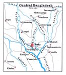
| Area | BURI GANGA RIVER | |
| Place | DHAKA | |
| Country | BANGLADSEH | |
| Topics | VISION FOR BURIGANGA RIVER | |
| Author(s) | MD ZASIM UDDIN & MAJEDA TUMPA | |

| ||
Rationale
- Why do you think this case is relevant? What is your hypothesis considering the landscape challenges?
- Bangladesh is the world's largest river delta and it empties into the Bay of Bengal with the combined waters of several river systems, mainly those of the Brahmaputra river and the Ganges river. It is also one of the most fertile regions in the world, thus earning the nickname the Green Delta. Although Bangladesh is riverine country, it suffers from flood in monsoon season and lack of water in dry season. Pollution of river is another major landscape challenge for Bangladesh.
Location and scope
You can edit this map with the map editor
Water as a natural system
Geomorphology, typologies and dynamics of water areas
- Describe the water areas of your area in the contxt of the wider water system
The river Burigana flows at the southwest part of the city, that part is known as the old dhaka. It is 7.6 meter deep in average and highest 18 meter deep. It is about 400 meter wide. It is originated from the Dhaleshwari river through karnatali tributary. Due to siltation and encroachment the river length shorten out. 11km of the river flows through Dhaka district and 7 km flows through Narayanganj district.
- How does water appear in the landscape of your living lab? What types of water areas are common?
Considering from the point of view usability, this river is one of the most busiest part of the city because of the launch terminal and also the most polluted one. Dhaka is surrounded by the different rivers, such as Balu, Buriganga, Turag, Tongikhal and shitalakshya rivers. Before, there were many canals were connected to the rivers. Over the period of times the canals got disconnected.
- Please identify the water bodies' catchment areas, tributaries and floodplains
- Which dynamics do these water areas have?
Buriganga river is historically important. It is one of the economic hub. As Dhaka is the capital city, most of the cities from southern part of Bangladesh are connected by the water ways that starts from Buriganga river.
- Have there been any flood events in the past?
Flooding has been a serious problem in the past. Afterwads, government took many initiatives including making river bank dam along with the riskier part of the river. but creating of such system is often put into scrutiny as though it prevents flood water coming into the city but whenever it rains in the monsoon season serious problem of water waterlogging happens inside the city.
- add 2-3 graphical representations to the image gallery, you can add more if you like
-
 add a caption
 -
add a caption
-
add a caption

Water as a living space
- Which habitats can be found in and along the water areas of your area?
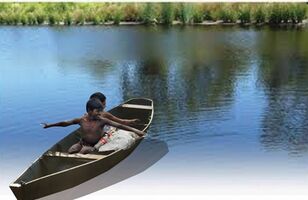
This is the most polluted river in the country which runs through the high density area. there hardly any habitats is found in this area.
- How is the water quality in your water areas?
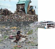
Water quality is poor in the river Buriganga. Chemical waste, industrial waste, solid waste etc. dumped into the river. The water color is dark black , and not usable for swimming or any other activity.
- Which areas are still natural, which are urbanized/artificial?
There’s a dam along with the river. most of the areas are artificial.
- add 1-2 graphical representations to the image gallery, you can add more if you like
-
add a caption
-
add a caption
Blue and Green Infrastructure
- What are the major potential elements of a green/blue infrastructure network? Are these likely to change/disappear? Why is that?
This is the most polluted river in the country. There’s hardly any green infrastructure along with the river. these green infrastructure is disappearing along with the river because of encroachment and also lack of awareness and planning policy. Along with the river there are bazaar areas developed. There are different kind of markets and mixed use areas have been growing up. Mostly grey infrastructure is visible.
- You find my background material on green infrastructure in our reading list
- add 1-2 graphical representations to the image gallery, you can add more if you like
-
add a caption
-
add a caption
Water as a cultural space
Land use and water
- map the land uses along your water areas: settlements, infrastructure, agriculture, resource extraction, natural areas, energy production...
- describe in particular the historical evolution of land use pattern, please make use of historical maps
- description evolution, status quo and driving forces, is the land use likely to change? Why is that? (approx 200 signs)
- add 1-2 graphical representations to the image gallery, you can add more if you like
-
 Land use along with Buriganga
 -
add a caption
-
add a caption

Cultural and spatial typologies of water areas
- Which spatial patterns have evolved in relation to your water areas?
- What is the role of water areas within the overall urban morphology? (approx 200 signs)
- Buriganga river serves in many ways in the urban contexts. One of the largest launch terminal situated here. It connects the capital city Dhaka, with the other cities by waterway. Goods and different materials are also transported to Dhaka by the river way. Most of the heritage sites of Dhaka situated along with the river burignga, which makes the river edge a touristic area for the city. many business hubs grew along with the river, like spice market, the market of other raw materials etc.
- add 1-2 graphical representations to the image gallery, you can add more if you like
-
 Business hub along with Buriganga river
 -
 Chawkbazar The 400-year-old bustling heart of Dhaka
 -
 93 heritage buildings, sites listed for preservation


Sacred spaces and heritage
- Which places/elements hold cultural value and to whom?
Buriganga river is situated along with the old Dhaka. Old Dhaka is referred to the older part of Dhaka. old Dhaka has a long history. It was founded in 1608 as a capital of Mughal province of Bengal which was later shifted. In old Dhaka there are many architectural heritage buildings still can be found. Many buildings from Mughal and colonial period are still situated here. The narrow streets in old Dhaka is an unique characteristics. Old Dhaka is also famous for food and celebrations. Different religious festivals from both muslim and hisdu religion are celebrated here festively. Other cultural celebration like ‘shakrain’ is also a popular celebration here, where people from other part of Dhaka join to participate. Along with muslims, there are significant number of hindu and moderate number of Christian also live here. There are also temples and churches situated here. Another unique characteristics of old Dhaka is the ‘ghat’ or terminal area for water transport. Evidence can be found these ‘ghats’ were mentioned even from Mughal period. Today one of the busiest terminal is Shadarghat terminal situated here which connects rest of the cities in Bangladesh. Here are few example of different structures: Ahsan manzil: it’s a palace for the nawab of Dhaka which was built in 1872. This is a very iconic building visible from the river buriganga
Northbrook hall: a building from british period which was used as a town hall. This is also known as the lal kuthi. This is situated at the farashgonj road in the old Dhaka. Swarighat: another establishment from the colonial period. It is the wholesale fish marked established in 1850. this market only operated few hours during the morning. Ruplal house: a 1825 mansion, this was made by an American business man, later bought by Ruplal Das and his brother Raghunath Das. this is also a very iconic building, currently used as spice market. Mill barrak: it was built as a company in the 1840s. Afterwards this establishment was sold to the British merchant William Foley who used it as a residence and also as a ware house. In 1857 during the Indian rebellion it was used as a temporary barrack for the British reinforcements. Currently it is used as a police training camp. This structure is also situated along with the river. Bara katra: this is one of the oldest building in Dhaka dating back from the Mughal period. This is situated close to the north bank of the river Buriganga. Chawkbazar: this is a market area established apporoxime 400 years back. It was one of the main business hub. Many wholesale products can be found here. Mitford hospital: another establishment from colonial period. This is one of the most important medical institute which is named after the philanthropist Robert Mitford. It was established in 1887 basically as a hospital. A medical school was built in 1875 close to hospital. This structure is also in the river bank.
- You may add a map and some images, please also explain in your caption why these elements are valuable
-
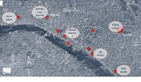 Cultural value and heritage along with Buriganga
 -
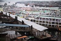 Sadarghat Launch Terminal-Dhaka
 -
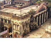
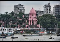 The Ahsan Manzil (Pink Palace) above the Buriganga River, Dhaka, Bangladesh


_above_the_Buriganga_River,_Dhaka,_Bangladesh.jpg)
Visual appearance and landscape narrative
- Which elements are essential for the landscape character?
- Has the landscape been painted or otherwise depicted, when and whom? Which elements are essential?
paintings ‘Bank of the old town’ by artist Sadek Ahmed,2019. This painting explores the view of the river Buriganga from the heritage site Ruplal house.
- Which narratives exist? Who has written about this landscape or depicted it in some way?
Buriganga river has been mentioned in many historical books. There’s a book by professor Muntasir Mamun ‘ Dhaka Somogro’ where old history of Dhaka written.
- You can add text and images
-
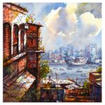 Bank of the Old Town Painting by Sadek Ahmed
 -
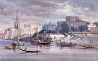 Dhaka City across Buriganga River in a 1861 painting 1
 -
Dhaka City across Buriganga River in a 1861 painting 2


Water and People
Accessibility and usability
- Where are your water areas accessible, and where not? How strong are spatial obstacles preventing access?
Our water area is accessible throughout the way. There’s a ring road along with the river. Every road open up to the ring road.
- Who is using the spaces and how?
As it is mentioned before this area has one of the biggest launch terminal. People come here to travel to the other cities by launch and other water vehicles. The ring road along with the river , it is vehicular. There’s no adequate pedestrian or bicycle path.
-
add a caption
-
add a caption
Community Mapping
What is to be mapped here?
- Social groups from within the community, for example the youth, kids, students, parents, the retired etc. Typically, these groups have specific needs, which you can also make explicit on the map. These people might not be organized in any way, but they are usually present in the context you are observing
- Local stakeholder groups: these groups are organized in one or the other way. They only exist within the community context you are observing. For example: the local community center, local churches, local interest groups, the landowners, small businesses and retailers
- External stakeholder groups are not necessarily present in the environment you are observing, but they may have strong stakes and interests. These can be local authorities, politicians, associations, care services etc.
- For each group, you may identify their needs, objectives, power and capacities
- You may also identify gaps and power conflicts
- Please try to redepict these elements in an integrated way and in relation to your water landscape. What is the relationship between these groups? Are they close or distanced from each other? Who is more powerful? Which voices are hardly heard? Do they have any shared concerns?
-
add a caption
-
add a caption
-
add a caption
Possible Futures
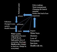
- You can summarize your findings with a SWOT diagram and a DPSI(R) Model
- Link back to the Sustainable Development Goals: Which goals are at risk?
Having clear water is at risks. Many illegal industrial waste is mixing into the water. There are also solid waste disposal too.
- What is your worst case scenario for this landscape?
Increasing pollution is the worst case scenario. It will create health hazards and will have impact on bio-diversity.
- What is your best case scenario for this landscape?
Best scenario is to have clear water. It will benefit the surrounding 1. Reduce pollution through sewage treatment. 2. Reduce solid waste dumping. 3. Control oil spill- laws and regulation. 4. Clean water for swimming, boating and other activity. 5. Clean water for usability.
- Present your scenarios in the form of a collage or sketch
- Add text and visuals
-
 explain your analysis briefly in the caption
 -
 explain your worst case scenario briefly in the caption
 -
 explain your best case scenario briefly in the caption


Collaborative Goal Setting
- Define strategic planning objectives based on the evaluation findings from your analysis
Historically there are many different types of infrastructure and use pattern have been developed over the period of times in the old Dhaka. These infrastructure ranges from wholesale bazaar to academia. There should be some kind of linkage to be present in spatial space. Such as connecting plaza, walkways, bicycle path etc. which can be designed to connect these infrastructures. A green belt is mandatory along with the river because currently only grey infrastructure is visible. There are only grey infrastructure, but parks, open green spaces are missing. Clean water is the basic for any kind of development and it is right to people.
It is difficult to ensure clean water for the river as many illegal swage and industrial waste is discharging to the water. It requires to identify such illegal bodies and take action. There must be laws and implementation of it. setting up STP and ETP to purify waste water which are discharging should be encouraged.
All heritage structure should be identified and requires to preserve them. Old Dhaka is the center of interest of Dhaka resident. People goes to old Dhaka to enjoy different types of festivals and cultural fabrics. Any kind of public development will encourage people to bring to the old Dhaka and it will be even more vibrant. Because of the pollution of the river Buriganaga and the water edge, it has made the back of the city, where else it has every possibility to become the front of the city. it requires both the development of the spatial spaces along with the clean water.
- Ideally, involve the community of your living labs into this process
- Link back to your original targets from section one and the Development Goals
- 150 words text contribution
Spatial Strategy and Transect
- translate your strategic goals into a vision
- develop a spatial translation of your vision
- exemplify your vision in the form of a transect with concrete interventions
- add map(s) and visualizations
-
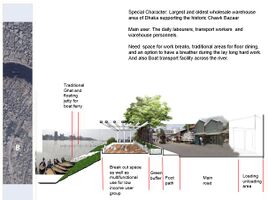
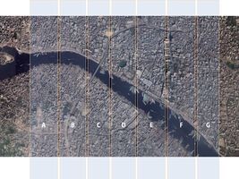 Transect plan through Buriganga river
 -
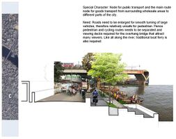
 Transect B
 -
 Transect C
 -
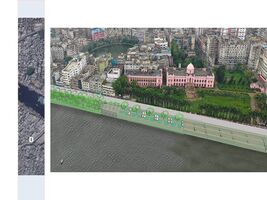 Transect D
 -
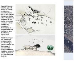 Transect F
 -
Transect G


From Theory of Change to Implementation
- For implementing your vision: Which partnerships are needed? Which governance model is required?
DCC: DHAKA CITY CORPORATION, BWTA: BANGLADESH WATER TRANSPORT AUTHORITY, PPP: PRIVATE AND PUBLIC PARTNERSHIP, Municipality including local stakeholders needs to be get involved. Along with the river there are different types of development can be identified. Such as, wholesale market, bazaar, illegal temporary structure, institutes, residential areas, ghat, terminals etc. different developments has different functions and different stakeholders. From the government agency there are also different types of authority like, roads and highways department, heritage authority, municipality etc. It requires public government partnership to do such development
- Who needs to act and how? Draw and explain a change/process model/timeline
COMMUNITY INVOLVEMENT: Development of river side of Buriganga river is a critical process because of the variety of stake holders and their involvements. This is hard to involve community for the development process. Participatory process is a new idea and there’s not many development projects has been done using this process. If clean water or green belt project goes for implementation it will be hard to involve community in it. development of Buriganga river edge, is a hot topic in Bangladesh and different agencies had tried before. One of the influential agency ‘BENGAL INSTITUTE’ arrange an exhibition with the development proposals but involvement of community was missing in this exhibition and in the design process. Arranging different types of workshops while design process can be a way of engaging people. Such projects where built and cultural heritage plays an important role needs people’s participations. It requires having a site office in the old Dhaka where different stakeholders may come and participate in the design process along with the workshops with them. It will also requires many survey done and summaries the local needs
- Which resources are needed? On which assets can you build?
- add 150 words text and visuals
-
 add caption here
 -
 add caption here


References
- give a full list of the references you have used for your case
Process Reflection
- Reflect in your intercultural and interdisciplinary team on the outcomes of your study
- Which limitations were you facing?
- What have you learnt from each other?
- What did you learn in the Living Labs?
- What would you do differently next time?
- You can also use diagrams/visuals
- 250 words text