WAVE Team 1 Nuertingen 2021
Jump to navigation
Jump to search
>>>back to working groups overview
| Area | Baden-Württemberg | |
| Place | Nürtingen | |
| Country | Germany | |
| Topics | WAVE Project | |
| Author(s) | Abhishek Vekariya, Mohit Sehrawat, Rehan Wasi | |

| ||
Rationale
- The focussed area of the Nuertingen Region is widely connected to the Steinach River, it is a tributary of the Neckar River.
- Steinach almost starts from the central Nuertingen and ends up near Neuffen. As it is the major water area of the region thus it adds more cultural and historical values to the region.
- While studying this area, we analyzed that people have lost interest in this River over time.
- Major landscape challenges such connectivity of human-water, biodiversity, aquatic life, etc.
Location and scope
- The Area of study is Nuertingen represented with the maps below.
You can edit this map with the map editor
-
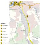
 OverView Map
 -
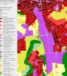
 Thematic Map - This is the focussed region of Nuertingen. Defining the Industrial land, forest cover, settlements, Steinach River, etc.
 -
 Base Map - Representing the Riparian Zone, Tributaries, standing water, Industrial land, forest cover, settlements,


Water as a natural system
Geomorphology, typologies and dynamics of water areas
- In our study area we found that Steinach is almost 2.6KM in length, whereas the overall length of the River is 13KM
- As the water progresses it changes the geography and topography of the areas, in our case, it flows from the North to South and changes the width of its course at several places. Wetland, river, are the common water areas
- We found 2 catchment area and one wetland, tributaries of Steinach River are such as Kummbach River, Ghaibach River and etc.
- Floods are one of Nürtingen's most significant issues. Areas, where there is a chance of flooding every hundred years, are designated as"flood areas," to which additional laws apply, according to the Baden-Württemberg Water Resources Act.
- Floods are sometimes to be expected twice a year in Steinach River, building measures are in place to take care of the floods. As however, The Neckar River, particularly had floods that occurred in 1824, 1926, 1978, 1990, and 2013. The historic flood wave that swept across the Neckar in October 1824 was the greatest flood the river had ever seen.
-
 Catchment areas
 -
 Flood plains


Water as a living space
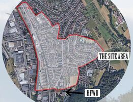
- On the left side of the Steinach lies the Industrial land and Residential on the other
- Water Quality depletes in most of the part in the focussed region
- The Natural Areas are almost very less and the area is almost completely urbanized except the forest and agriculture cover
- The River Structure was changed over the course of time and some man made slopes were created into the river due to which aquatic life has been impacted on a very large scale
-
 Water quality
 -
 Spaces along river
 -
 Water structure


Blue and Green Infrastructure
- Climate change adaptation/mitigation, Water management, Biodiversity, Local characteristics are the potential elements of green/blue infrastructure network. Climate change will likely be heading with a steady increase and also other factors will be directly affected. Basically due to numerous construction along the river and river structure affects both biodiversity and aquatic life
-
 Blue infrastructure map
 -
 Green infrastructure


Water as a cultural space
Land use and water
- The Land Use of the place changed as the population rose and demand of industries increased and also the settlements
- The focussed region is almost 70% already urbanized with industries, residential dwellings, thus the rest of the land falls under the protected land or he green cover. The landuse has been utilized to its complete potential and doesn't need to change in near future
-
 Urban Area Map
 -
 1824 Landuse Map
 -
 1940 Landuse Map
 -
 1980 Landuse Map
 -
 2020 Landuse Map


Cultural and spatial typologies of water areas
- Along the Steinach River there are lots of spaces which are formed with very dense natural wild vegetation for better biodiversity and also very few open spaces with very less area
- Steinach was beautiful when it was in its natural state but after the construction of the Dam, some slopes were created in the river which impacted the Aquatic life.
Sacred spaces and heritage
- Nürtingen city dates back to the 6th & 7th centuries, several places and elements are present to add historical value in it, especially in the central part of the city. The central part of the city is located a little bit above the normal level, on a hilltop, which makes this area more historically valuable since every building has survived floods that were happening in the past years. This place a huge role in the identity of the city, bringing it more valuable to the locals as well as to tourists.
-
 Monuments and sacred places map

Visual appearance and landscape narrative
- The water areas, Neckar and its tributary Steinach, formed the landscape of Nürtingen in the town it is today.
- Mark Twain, famous American writer, and Friedrich Hölderlin, German philosopher and poet, depicted the Neckar in rather idyllic way. Mark Twain explained and used Neckar as the inspiration for the A Tramp Abroad: "“Germany, in the summer, is the perfection of the beautiful, but nobody has understood, and realized, and enjoyed the utmost possibilities of this soft and peaceful beauty unless he has voyaged down the Neckar on a raft. The motion of a raft is the needful motion; it is gentle, and gliding, and smooth, and noiseless; it calms down all feverish activities, it soothes to sleep all nervous hurry and impatience; under its restful influence all the troubles and vexations and sorrows that harass the mind vanish away, and existence becomes a dream, a charm, a deep and tranquil ecstasy. How it contrasts with hot and perspiring pedestrianism, and dusty and deafening railroad rush, and tedious jolting behind tired horses over blinding white roads!”. Hölderlin wrote a poem that is called The Neckar: "...The sighs of the poor people into songs, When the pomegranate ripens, when the orange trees, Nod in a green night, and the gum trees drip, Resin, and drums and cymbals resound, To labyrinthine dances. Perhaps someday my guardian deity will bring me, To these islands, but even then my thoughts, Would remain loyal to the Neckar, With its lovely meadows and pastoral shores
- Famous cartographer, Andreas Kieser, made various maps and paintings trying to depict the landscape and Neckar in Nürtingen. There are also postcards dating from 1907 and later which try to show the character and what the landscape of Nürtingen consists (market, church, historical center, fountain)
-
 Esslingen & Neckar - Floodplain & Natural meadows
 -


Water and People
Accessibility and usability
- Most of the focussed part has no direct access to the Steinach River, because of the excessive settlements and industries on both the sides
- These spaces are being used as in a private garden of the owner, where they plant, store, farm and etc
-
 No Access from either side
 -
 Lacks Seating Areas
 -
 Access blocked by fences or Boundary walls


Community Mapping
What is to be mapped here?
- Social groups from within the community, for example the youth, kids, students, parents, the retired etc. Typically, these groups have specific needs, which you can also make explicit on the map. These people might not be organized in any way, but they are usually present in the context you are observing
- Local stakeholder groups: these groups are organized in one or the other way. They only exist within the community context you are observing. For example: the local community center, local churches, local interest groups, the landowners, small businesses and retailers
- External stakeholder groups are not necessarily present in the environment you are observing, but they may have strong stakes and interests. These can be local authorities, politicians, associations, care services etc.
- For each group, you may identify their needs, objectives, power and capacities
- You may also identify gaps and power conflicts
- Please try to redepict these elements in an integrated way and in relation to your water landscape. What is the relationship between these groups? Are they close or distanced from each other? Who is more powerful? Which voices are hardly heard? Do they have any shared concerns?
-
 add a caption

Possible Futures
- You can summarize your findings with a SWOT diagram and a DPSI(R) Model
- Link back to the Sustainable Development Goals: Which goals are at risk?
- What is your worst case scenario for this landscape?
- What is your best case scenario for this landscape?
- Present your scenarios in the form of a collage or sketch
- Add text and visuals
-
 Rsponses
 -
 Swot analysis
 -
 Scenario 1
 -
 Scenario 2
 -
 Scenario 3
 -
 Alternative scenario


Collaborative Goal Setting
- Developing the accessibility to the Steinach which allows the interaction of humans with the ecosystem, and the river body as well
- Cleaning the river sites to make it more inviting for the people around
- Biodiversity needs to be developed in a more natural system in order to make the habitat more regenerative
Spatial Strategy and Transect
- Creating different gradients along the river to connect the community and native biodiversity with the river Steinach. The Vision is to make the river accessible to the people so they can joyfully enjoy the water areas. For inviting people to the river we thought of redesigning the spaces to make it more welcoming.
-
 The focussed Braike Neighbourhood Water area in form of Steinach River
 -
 Seating Near the River in colorful flower beds
 -
 Staircase into the river for easy accessibilty and bridges for connectivity
 -
 Street painted colorfully and designed with games
 -
 Designing decks as cantilever spaces
 -
 OAT for small fun activity
 -
 Creating stone walls and seating deck
 -
 Adding road crossings


.jpeg)
.jpeg)

.jpeg)
From Theory of Change to Implementation
- For implementing your vision: Which partnerships are needed? Which governance model is required?
- Who needs to act and how? Draw and explain a change/process model/timeline
- Which resources are needed? On which assets can you build?
-
 Even this man was 65 years old and yet he wanted to enjoy
 -
 Encouraging the community for social events
 -
 Products made of waste products
 -
 Enaging the community
 -
 Inviting local people to participate in acitivities


References
- https://udo.lubw.baden-wuerttemberg.de/public/pages/map/default/index.xhtml?mapSrs=EPSG%3A25832&mapExtent=224048.3012048193%2C5247036.86746988%2C774357.6987951808%2C5532509.86746988
- https://www.bluemarblegeo.com/global-mapper/
- https://www.google.com/maps
- https://en.wikipedia.org/wiki/Steinach
- https://commons.wikimedia.org/wiki/File:N%C3%BCrtingen,_Andreas_Kieser.png
- https://de.nailizakon.com/n/01-bw/nurtingen/nurtingen.html
- https://miro.com/app/board/o9J_l_2D-xE=/
Process Reflection
- As a team, we really enjoyed and learned the process of how to study, assess, conceptualize the chosen landscape areas.
- We faced the limitation of communication and different time zone situation, but as the project was further processed we came to good communication.
- As we belong to different backgrounds, cultures, and geography, we shared a lot of things in common and learned how to manage, process, and innovate different techniques and strategies to overcome the design challenges
- Maybe next time we would try to involve the community as soon as possible and communicate with them to better understand the location and other aspects of the areas