Water and Heritage WAVE Living Lab 2021
>>>back to working groups overview
| Area | Phlegraean Fields | |
| Place | Phlegraean peninsula | |
| Country | Italy | |
| Topics | Archeology, Accessibility, Natural Phonomena | |
| Author(s) | Ferdinando Romano, Maria Russo | |

| ||
Rationale
- Why do you think this case is relevant? What is your hypothesis considering the landscape challenges?
The Phlegraean Fields have great historical, landscape and territorial importance, for this reason, it was the destination of many intellectuals from all over Europe during the Gran Tour between the XVII and the XIX century. Among these, Goethe gives an extensive description in his Journey to Italy of Phplegrean fields.
In a few square kilometers, The Phlegraean Fields offer, a great variety of naturalistic and anthropic elements. A smoking crater, beaches, promontories, thermal baths, mysterious caves, ancient cities sumberged due to bradyseism, but also one of the major Italian archaeological museums and then the ancient monuments of Puteoli, Baia, Miseno and Cuma.
In 2003, thanks to the Campania Regional Law n. 33 of 1/9/1993, was established The Phlegraean Fields Regional Park, whose areas of greatest biological and natural value are Capo Miseno, the submerged park of Baia, Monte Nuovo and the Cratere degli Astroni.
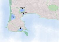
Location and scope
You can edit this map with the map editor
Water as a natural system
Geomorphology, typologies and dynamics of water areas
- Describe the water areas of your area in the contxt of the wider water system
The area of the Phlegraean fields is a large caldera in a state of quiescence, located in the Gulf of Pozzuoli, west of the city of Naples. The etymology of the Phlegraean fields refers to the Greek word "phlegrea", meaning ardent, which burns beacause this area has been known since ancient times for its lively volcanic activity. The Phlegraean area includes in particular the municipalities of Naples, Pozzuoli, Quarto, Giugliano in Campania, Bacoli and Monte di Procida.
- How does water appear in the landscape of your living lab? What types of water areas are common?
The Phlegraean landscape is characterized by low hills and small craters that can host picturesque lakes, on one side, and the splendid sea on the other. Within the area there are many craters and small volcanoes, some of which have effusive gaseous manifestations, as the Solfatara area of Pozzuoli, or thermal water, as Agnano, Pozzuoli, Lucrino, which cause of the phenomenon of bradyseism. Important deposits of volcanic origin are visible throughout the area such as Tufo grigio campano (or Campana Ignimbrite) or tufo giallo, used as construction materials. In the area there are lakes of volcanic origin (Lake Averno) and coastal lakes originating from barrages (Lake Lucrino, Lake Fusaro, and Lake Miseno). In addiction, many other craters have been identified in the Gulf of Pozzuoli, sunk into the sea or disintegrated by it over the millennia.
- Please identify the water bodies' catchment areas, tributaries and floodplains
According to a study by the Department of Earth Science of the "Federico II" University of Naples, the flash floods that hit the area of Pozzuoli and Campi Flegrei cause torrential rains throughout the territory, due to Ischia. In particular, the two water storms that hit Pozzuoli and the Phlegraean area on 7 and 11 September 2017 and which caused extensive damage to the area.
Specifically, the study reports that the origin of these phenomena is attributable to Mount Epomeo in Ischia, the island in the Gulf of Naples, not far from the Phlegraean coasts. When an atmospheric perturbation of the Tyrrhenian from Ischia arrives in Pozzuoli, Mount Epomeo causes a sudden rise in the humid sea air, which condenses and pours, in rainfall, on Pozzuoli and on the coast of the Phlegraean Fields.
According to the study, the floods in the Phlegraean area can instead be predicted by studying the direction of the disturbance and monitoring the rainfall in real time in Bacoli, a town located about halfway between Pozzuoli and the island of Ischia.
- Which dynamics do these water areas have? Have there been any flood events in the past?
The Phlegraean Fields are actually a vast volcanic field within which, in the last 39,000 years, numerous different eruptive centers have been active.
Even in Pozzuoli Lake Averno, located inside a volcanic crater, in ancient times was considered by the Greeks and Romans as one of the places of access to the underworld due to the lethal volcanic gases coming from the lake.
The most characteristic volcanic phenomenon of this area, is bradyseism. A periodic lifting or lowering of the soil, at a pace fast enough for geological times but so slow that man does not personally feel the variation in the height of the soil. The phenomenon is observed along the coast of the sea or the buildings that emerge or are submerged. The Temple of Serapis in Pozzuoli is an example.
Water system

Phlegrean caldera source:campiflegreinews.it


Water as a living space
- Which habitats can be found in and along the water areas of your area?
The importance of Phlegreean Fields is mainly due to their millenary history. Here were built the first Greek settlements in Italy, for this reason we can find here several archaeological remains of considerable importance.
A land of ancient legends bordered by the Posillipo hill, by Miseno and Cuma thanks to the mild climate and the fertility of the soil, the Campi Flegrei attracted various populations since ancient times, including Greek settlers from the nearby island of Ischia, followed by Etruscans, Samnites and Romans.
Many artists and writers were fascinated by this territory, so much so that Homer and Virgil set some events of their epic poems in these places.
Here they had their luxurious residences, patricians and emperors of Rome. A territory rich in historical evidence, therefore, which is perfectly combined with legends and mysteries.
- How is the water quality in your water areas?
According to the checks carried out, as required by the ARPAC, the concentration of bacteria in the waters of the Phlegraean coast remained well below the limits, except for the stretch of water near the acropolis of Cuma, where however bathing is prohibited.
According to the Arpac classification, the quality of the sea in the Pozzuoli area is "excellent" in the stretches of coast between Cantieri-Arco Felice and Lucrino and up to the border with the city of Naples. The remaining stretch between Rione Terra and Corso Umberto is classified as "sufficient".
On the other hand, on the Cuma-Licola side,the situation is less positive: the waters north of the Purifier are classified as "good", while the waters near the mouth of Licola are classified as "inadeguated".
- Which areas are still natural, which are urbanised/artificial?
In the fleegre fields there is a disorderly urbanization that is concentrated around three main centers: Bacoli, Monte di Procida, Pozzuoli. They are reminiscent of the Roman city, Baia, which, due to local bradyseism, has been submerged near the coast of Bacoli for centuries. The areas that have preserved a greater naturalness are concentrated near the lakes and volcanic craters, as they are protected by the Italian state. Another important natural area is the one that runs west along the coast, but is degraded and abandoned to itself. Furthermore, the importance of territories destined for agricultural use is strong in the territory, they are therefore natural even if anthropized.
- Are the rivers permeable for fish or blocked by artificial elements?(approx 200 signs)
- add 1-2 graphical representations to the image gallery, you can add more if you like
- Yourcase wateraslivingspace1.jpg
add a caption
- Yourcase wateraslivingspace2.jpg
add a caption
- Yourcase wateraslivingspace3.jpg
add a caption
Blue and Green Infrastructure
- What are the major potential elements of a green/blue infrastructure network? Are these likely to change/disappear? Why is that?
The current potential of a green / blue infrastructure is due to the particularity of the territory influenced by Vesuvius. Very important are the natural thermal sources located in the area, not exploited to the fullest. The lake system is mainly exploited for its natural qualities through fish farming. In the northern area of the Campi Flegrei there is a more intense exploitation of the land through crops.We believe that the current infrastructures will hardly change, as the territory is strongly consolidated in the current structure.

Cratere degli Astroni natural reserve

Ciclopedestrian lane around Fusaro Lake

Torre Fumo paths, in Monte di Procida

Path on Capo Miseno


Water as a cultural space
Land use and water
- map the land uses along your water areas: settlements, infrastructure, agriculture, resource extraction, natural areas, energy production...
Around the water centers we have diversity of use. The most urbanized lakes are undoubtedly Lake Fusaro and Lake Miseno as they are incorporated into the urban context of Bacoli and Monte di Procida. Agricultural productivity is concentrated near Lake Averno, as it is located further north than the city centers, in an area mostly exploited for agricultural use. The entire area is also part of the Campi Flegrei Regional Park, and for this reason they are placed under protection.
- description evolution, status quo and driving forces, is the land use likely to change? Why is that? (approx 200 signs)
The first city of the Phlegraean Fields was Cuma, a Greek colony, famous for the Sibilla , the oracle of Apollo. In succession, the second city to appear is Puteoli (Pozzuoli). Important in Roman times especially for the thermal springs of volcanic origin due to the nearby Vesuvius. The slow sinking of part of the city, due to local bradyseism, caused its slow decline. Historically there is no predisposition to change in land use. It would be important to make the most of the natural thermal sources, excellence of the territory.

add a caption

add a caption


Cultural and spatial typologies of water areas
- Which spatial patterns have evolved in relation to your water areas? What is the role of water areas within the overall urban morphology?
In the ancient tiemes Pozzuoli was considered the "capital" of the Phlegraean Fields. It was founded by the Greeks and called by the Romans "Puteoli", known also as the largest port in the Tyrrhenian sea. Among the most important and beautiful sites: the Flavian Amphitheater (from the 2nd century BC), Rione Terra (ancient acropolis of Puteoli), Temple of Serapis, actually an ancient market, and Temples of Augustus and Neptune.
The city of Baia, near Puteoli, was one of the most popular vacation spots in Roman times. Today it is home to the Archaeological Museum of the Phlegraean Fields in the Baia castle which is located overlooking the sea, the submerged city of Baia (an ancient Roman city, submerged due to bradyseism) and the Archaeological Park of Baia (a complex with patrician villas , an imperial palace and the Temple of Mercury).
The oldest part of the Camp Flegrei is certainly the ancient city of Cuma, the first Greek colony of the eighth century BC and a thriving commercial city. Known for the Cave of the Sibyl, legendary priestess of Apollo, the Temple of Jupiter (Greek temple of the fifth century BC) and the Temple of Apollo.
At the end of the Phlegraean peninsula there is Miseno, known for being the burial place of the trumpeter of Aeneas, with the Piscina Mirabilis, Roman tank dug into the tuff.
These places are characterized by the presence of volcanic lakes such as Averno Lake, Lucrino Lake and Fusaro Lake.
- add 1-2 graphical representations to the image gallery, you can add more if you like

Port of Puteoli, drawing by Bellori

Rappresentation of ancient Puteoli
.jpg)
.jpg)
Sacred spaces and heritage
- Which places/elements hold cultural value and to whom?
Archaeological excavations carried out starting in 1941 revealed a stratification of buildings, villas and thermal complexes, dating back to the Republican age, the Augustan age and the Hadrian age.
Among the most significant archaeological evidence there are the temple of diana, of mercury and the temple of venus: these are not sacred tample, but thermal baths for which it has remained the popular name.
Temple of Diana - Differently from what the name suggests, it is not a temple, as the antiquarian tradition had hypothesized, but thermal complex that exploited the rising of hot springs, built near the ancient volcanic crater. The connection to Diana, goddess of the Hunt, is due to the discovery in the area of a marble relief depicting a series of animals, which is assumed to be one of the decorative elements of the walls. Scholars hypothesize that this building is the last of the great thermal complexes of Baia, probably built around the third century AD.
Temple of Mercury - Takes its name from the thermal temple with a circular plan with a domed vault, which was called "temple of mercury" by the first travelers of the Grand Tour and is composed of two building nuclei, the first of which is little known because the rooms they are buried and submerged up to the vault shutter or have been destroyed by modern constructions.
Temple of Venus - This building with a diameter of over 25 meters was the most important room of a larger complex, which most of the rooms have been lost. Although today is partially underground, its majesty has always intrigued travelers and architects, such as Palladio, who wanted to draw it, fascinated by its architectural features: its octagonal outside, circular inside and its dome . On the central hall there are also niches, which in turn gave access to other smaller rooms: it is thought that these were the basins of a large bath, in continuity with the other complexes excavated in the Gulf of Baia. All the rooms had to be covered with marble slabs and the decoration of the dome was composed of a mosaic, of which we still have very small traces. Given the technical characteristics implemented, the client seems to be the emperor Hadrian himself, especially considering the numerous similarities with some buildings he wanted in his villa in Tivoli, just outside Rome. It is assumed that the buildings within the Parco delle Terme di Baia are also part of the same complex.
Temple of Apollo - Along the Via Sacra, o placed on a large natural terrace, there is this temple which has been completely destroyed over time. Also known as the Lower Terrace, it included a series of sacred spaces, parts of a large sanctuary. It is characterized by the presence of small pools, supplied with water recovered from a cistern from the Greek age near the terrace, probably used for sacred rituals.
The temple was built in the sixth century. B.C., attributed to Apollo for the discovery of an altar dedicated to him, but maybe it could also have been destined to Hera on the basis of inscriptions found in the area, but there is little information that can confirm the attribution.
In the Augustan age the building was the subject of an important renovation which preserved only the original base, renewing the elevated structures with the addition of a monumental pronaos on the long side, which took up the compositional scheme of the temple of Concordia in Rome.
Around the fifth century. A.D. the temple was transformed into a Christian cathedral. Nowdays there are the only remains of the colonnades and the perimeter bases of the rooms that conformed it remain.
Temple of Serapis - The term Serapeum means a temple or other religious structure, dedicated to the syncretic deity Serapis, venerated in ancient Egypt.
It is one of the most important monuments of the period in which Puteoli was a Roman colony and all the Phlegrean fields had a rich commercial port activity. It was considered the sacred templ dedicated to the god Serapis due to the discovery of a statue of the god in the eighteenth century. But actually it is the remains of the public market, called macellum, of Puteoli, presumably built in the Flavian era between the 1st-2nd century AD.
The macellum layout is quite typical: the arcaded central square, with access to the sea, was surrounded by rows of tabernae (shops) accessible from the square or from the perimeter roads. The complex was covered and paved with marble slabs and decorated with bas-relief friezes. On the columns it is possible to see traces of molluscs. In fact, again due to bradyseism for a certain period, the Macellum found itself below sea level.
Temple of Neptune - The so-called temple of Neptune in Pozzuoli is actually what remains of a large public thermal baths in the ancient city of Puteoli. This complex was specially designed to obtain a great scenographic effect for those coming from the sea: indeed it is arranged on several levels sloping down towards the port.
The building dates back to the 2nd century AD, built with bricks and opus recitolatum, but was later enlarged and renovated during the Severian age and evidenced by the stamps and also by the annexed Nymphaeum of Diana, which was built in conjunction with the restoration of the baths.
Like all Roman thermal buildings, the spaces were distributed in a linear way: one entered from the natatio, followed by the frigidarium for cold baths, the tepidarium for setting and the calidarium for hot baths. These last two rooms are currently incorporated into the other buildings.
The thermal complex was used until the fourth century AD, subsequently during the period of the decline of Roman Empire , it fell into disrepair due to the difficulties in keeping the water supply system operational.
Unlike other monuments that were buried over the centuries, the baths remained exposed to all kinds of plundering and meteoric aggression, handing us a small part of what this monumental building was, no less important than the baths of Diocletian and Trajan in Rome are.
- You may add a map and some images, please also explain in your caption why these elements are valuable

Temple of Diana

Temple of Mercury

Temple of Venus

Temple of Apollo

Temple of Serapis


Visual appearance and landscape narrative
- Which elements are essential for the landscape character?
Water has always been the central focus of ancient activities and settlements in the Phlegrean Fields: cisterns, aqueducts, thermal baths and nymplheas where water-related rituals were celebrated are still archeological evidence ogf the ancient connection with area's unique places.
- Has the landscape been painted or otherwise depicted, when and whom? Which elements are essential?
The perception of Phlegrean Fields has always shown the dualism of nature and anthropic actions through the time. For this reason, archeology is the key to understand the identity of the area. During the Renaissance intellectuals used to visit Phlegrean fields to visit culture, lifestyle and architecture tecniques of ancient Romans and how they adapted and integrated them in a volcanic area.
- Which narratives exist? Who has written about this landscape or depicted it in some way?
From the mid-eighteenth century, the Grand Tours began, during which young intellectuals learned about politics, culture, art and antiquities of European countries.
Thanks to the heritage of ancient Rome, Italy became one of the most popular places to visit. During the journey the young intellectuals could visit the ruins of Rome, but also of Pompeii and Herculaneum, which had recently been discovered.
Among the most important stops on the tour, there was a visit to Naples and the Phlegraean fields which offered the opportunity to visit archaeological sites and natural phenomena, such as volcanic activity, as told by Goethe in Viaggio in Italia.
As well as, there are tens of thousands of paintings of Baia, Pozzuoli, Cuma and all the rest of the Phlegraean fields in all the world.
The places of the Phlegraean fields reflected the current of romanticism born in Europe, characterized by rural landscapes, ruins of an ancient civilization, where history and nature become one.
Among the most frequent stops: the macellum of Pozzuoli, the submerged city of Baia, the thermal baths and the volcanic lakes.
- You can add text and images

Sir William Hamilton at solfatara of Pozzuoli

Sir William Hamilton, Pozzuoli 1776

Franz Ludwing Catel, Rione Terra 1830

.jpg)
.jpg)
Water and People
Accessibility and usability
- Where are your water areas accessible, and where not? How strong are spatial obstacles preventing access?
One of the most important problems of the area is the poor accessibility to places of interest. This is especially evident in summer when the local population flocks to the bathing sites as the beaches are cut off from the railway line that isolates them from the hinterland.The reason why this happens is the poor quality and quantity of road connections and the total abandonment of existing ones, moreover there is a very serious insufficiency of public transport which are often disorganized, old and lacking.The easiest to access sites are certainly those on the coast, but they are still poorly connected.Lake sites have few and limited access points. However, this is not entirely a negativity as they are elements with a strong natural component, so huge human access could be harmful.
- Who is using the spaces and how?
The coastal areas are used by the local population especially in the summer as they are bathing establishments with large areas of "free beach" and therefore within everyone's reach.The lake areas are a prerogative for activities more marked by nature and culture and are mostly entrusted to associations aimed at safeguarding the sites. It is therefore accessed by a certainly smaller audience, even if more continuous and not only seasonal.

add a caption


Community Mapping
- Social groups
| Needs | Objectives | Power | Capacities | |
|---|---|---|---|---|
| Students | Places to study and do sport activities | Have places where could socialize and enjoy the landscapes | Active in associations | Represent the future
generations |
| Local dealers | More infrastructures | Improve their local shops, their tourism related activities | Voters | Political supports |
| Senior citizens | More public transports, places for free time | Have more open air spaces | Voters | Political support |
| Tourists | Regional transports that linkes Campi Flegrei with train station and airport | Enjoy the heritage and the landscapes | Capital | X |
- Local stakeholder groups:
FREE BACOLI: is a project carried out by a group of citizens, who are committed to improving the city from the criticalities of the Phlegraean territory. The association is committed to promoting the urban recovery of the city, especially the historic center,
through the redevelopment of public areas and parks, the limited traffic area, the pedestrian areas and shuffle for the bathing areas.
DIAMO A BACOLI: is a political-cultural association made up of the citizens of Bacoli who have freely decided to put their individual skills at the service of the country they live in, to improve the conditions of this municipality
PERCORSI CUMANI: local associaton that proposes the ciclomobility identifying a series of paths along the entire stretch of coast that goes from Nisida to Miseno, crossing the Flegrean municipalities of Pozzuoli, Bacoli and Monte di Procida.


Possible Futures
- You can summarize your findings with a SWOT diagram and a DPSI(R) Model
- Link back to the Sustainable Development Goals: Which goals are at risk?
- What is your worst case scenario for this landscape? What is your best case scenario for this landscape?
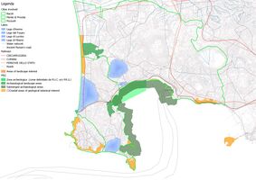
About future scenarios, we have identified the main topics that characterized the water area: archeology heritage, accessibility and natural ecosystem. With the lighter colour is rappresented the forecast of a probably future where the water area is abandoned to itself. With the darkest colous is rappresented the scenario of a future characterized by the development and management of potentials of the area.
In the first hypothesis, we can see the archeological resouce abandoned because it isn’t valued or safeguarded enough. In the second hypothesis we provide the development of new cycle paths that could improve the tourism in the archeological areas.
The second forecast is about the accessibility. In the first case we see an increase of pollution caused by traffic and the abcence of transport and green infrastructure in the area. In the second case we forecast the development of a network of pedestrian paths and the increase in public transport to promote sustainable tourism.
The last scenarious concerned the natural ecosystem. We forecast that in the future the increace a pollution of water and soil will cause the raising of the water level, the loss of marine biodiversity and the disappearance of natural areas. The darker direction rappresented we can see the possibility that will be teaken misures in order to mitigate the effects of pollution, in order to preserve the integrity of the ecosystem.
- Present your scenarios in the form of a collage or sketch
- Add text and visuals


Collaborative Goal Setting
- Define strategic planning objectives based on the evaluation findings from your analysis
1. Enhancement and management the historical resources of territory promoting routes and guided tours;
2. Management to safeguard the ecosystem of the area through water reclamation works;
3. Increase public transports to connect all the area of Phlegrean Fieds and improving green mobility;
4. Reconnect the existing green infrastructure through identification of a cycle-pedestrian path;
5. Involve the blue infrastructure with a seataxi system to connect the coasts and the lakes of Phlegrean Fields.

Spatial Strategy and Transect
- Strategic Goals: we have identified three main areas on the territory of the Phlegraean fields where to place the transects. These areas are characterized by the presence of archaeological sites, landscape and main blue infrastructures. The aim is to create cycle and pedestrian paths in these able of connecting the main heritage points and enhancing the natural areas throungh structures thar could be used by community.

- Transects with concrete interventions

From Theory of Change to Implementation
- For implementing your vision: Which partnerships are needed? Which governance model is required?
Our goal is to achieve a sustainable regeneration of the territory, enhancing the archaeological heritage, increasing public transport, creating a network of green routes and connecting the water areas through blue infrastructure. To carried out this vision is necessary The implementation of principles, rules and procedures concerning the management and governance of the interested areas.
- Who needs to act and how? Draw and explain a change/process model/timeline
Main actors of the vision:
- Public Administration
- National Authority
- Regional Park Authority
- European Authorities
- Public associations
- Local citiziens
- Economic operetors
To carry out the project, we belive that collaboration between the public administration and private investors is necessary. The municipal administration would provide for the regeneration of the areas and give general directives on the intervention, subsequently delegating to the private investor that could have commercial benefits from it. For example, private individuals could invest in seatransport, such as taxi boat or boat tour for tourists, but also in local shops close to archaeological sites and along cycle paths.

References
- http://www.archeoflegrei.it/i-campi-flegrei/
- https://www.napoli-turistica.com/campi-flegrei/
- https://www.cronacaflegrea.it/campi-flegrei-larpac-conferma-il-buono-stato-igienico-sanitario-del-mare-flegreo/
- http://www.pafleg.it/
- http://www.campiflegrei.it/desktop/TempiodiApolloCuma.html
- https://www.3bmeteo.com/giornale-meteo/campi-flegrei--uno-dei-10-supervulcani-esistenti-al-mondo--63056
- https://ludoviguida.com/index.php/itinerari/itinerari-classici/i-campi-flegrei/
- https://programmazionestrategica.beniculturali.it/progetto/campi-flegrei-baia-fra-terra-e-mare/
- http://www.regione.campania.it/regione/it/tematiche/piano-territoriale-regionale-ptr
Process Reflection
- Reflect in your intercultural and interdisciplinary team on the outcomes of your study. What have you learnt from each other?What did you learn in the Living Labs?
The WAVE has been an interesting experience that allowed us to approach to urban design in way, with a particular attention to natural phenomena, sustenibility and community necessities. It also allowed us to study our water areas and discover their huge natural and hystorical heritage. Moreover get in with local associations and citiziens of our areas and know their needs, helped us to find the best solutions for our vision.